263:
71:
231:, an engineer working as leader of an Expedition commissioned for surveying the western of Venezuela, climbed the mountain, however, Jahn named the mountain "Tucaní" and on the other hand named "Pan de Azúcar" another neighbor mountain now known as
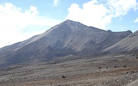
46:. Its name, which translates as "Bread of Sugar", is due to the sandy slopes of the mountain, which resembles "Pan dulce", a kind of bread sprinkled with sugar eaten in the country. The summit offers a scenic view, including
212:, the capital city of the state. The mountain, along with other mountains surrounds a high altitude valley around 4300 meters above sea level, which is the birth of the
300:
281:
103:
20:
251:, from October to March. The principal access is through the "La Culata" settlement. The normal route is through the South ridge.
295:
96:
51:
31:
209:
213:
161:
55:
39:
232:
276:
Silva, Gustavo (2001). "Los Picos más altos del Estado Mérida-Venezuela". Rev. Geog. Venez.
244:
143:
43:
224:
154:
47:
262:
289:
195:
268:
228:
187:
177:
70:
247:, due to its accessibility and fast approximation. It is best climbed during the
258:
248:
118:
105:
147:
35:
86:
208:
Pico Pan de Azúcar is located 27.7 kilometers to the
Northeast of
165:
75:
Pico Pan de Azúcar as seen from the East at Alto de Mucujún
243:
Pan de Azúcar is one of the most climbed mountains in the
186:
176:
171:
153:
139:
134:
95:
85:
80:
63:
223:The first ascent, made by the German explorer
8:
60:
54:and the surrounding mountains of the
7:
34:, is the ninth highest mountain of
14:
261:
69:
38:, and the third highest of the
182:Wilhem Sievers, June 5th, 1885
21:Pan de Azúcar (disambiguation)
1:
91:4,680 m (15,350 ft)
227:, dates from 1885. In 1910,
301:Geography of Mérida (state)
317:
18:
68:
52:Sierra Nevada de Mérida
296:Mountains of Venezuela
32:meters above sea level
16:Mountain in Venezuela
19:For other uses, see
162:Sierra de la Culata
115: /
56:Sierra de la Culata
40:Sierra de la Culata
81:Highest point
64:Pico Pan de Azúcar
28:Pico Pan de Azúcar
201:
200:
194:Walk, easy climb
308:
271:
266:
265:
190:
157:
130:
129:
127:
126:
125:
120:
119:8.800°N 70.983°W
116:
113:
112:
111:
108:
73:
61:
316:
315:
311:
310:
309:
307:
306:
305:
286:
285:
267:
260:
257:
241:
221:
206:
188:
155:
123:
121:
117:
114:
109:
106:
104:
102:
101:
76:
24:
17:
12:
11:
5:
314:
312:
304:
303:
298:
288:
287:
284:
283:
273:
272:
256:
253:
240:
237:
225:Wilhem Sievers
220:
217:
210:Mérida, Mérida
205:
202:
199:
198:
192:
184:
183:
180:
174:
173:
169:
168:
159:
151:
150:
141:
137:
136:
132:
131:
124:8.800; -70.983
99:
93:
92:
89:
83:
82:
78:
77:
74:
66:
65:
48:Lake Maracaibo
15:
13:
10:
9:
6:
4:
3:
2:
313:
302:
299:
297:
294:
293:
291:
282:
279:
275:
274:
270:
264:
259:
254:
252:
250:
246:
238:
236:
234:
230:
226:
218:
216:
215:
214:Mucujún river
211:
203:
197:
193:
191:
189:Easiest route
185:
181:
179:
175:
170:
167:
163:
160:
158:
152:
149:
145:
142:
138:
133:
128:
100:
98:
94:
90:
88:
84:
79:
72:
67:
62:
59:
57:
53:
49:
45:
42:range in the
41:
37:
33:
29:
22:
277:
269:Andes portal
245:Mérida state
242:
229:Alfredo Jahn
222:
207:
178:First ascent
156:Parent range
144:Mérida state
44:Mérida State
27:
25:
122: /
97:Coordinates
290:Categories
255:References
249:dry season
233:Pan de Sal
30:, at 4680
148:Venezuela
135:Geography
87:Elevation
36:Venezuela
239:Climbing
204:Location
172:Climbing
140:Location
219:History
110:70°59′W
107:8°48′N
166:Andes
26:The
280:(1)
292::
278:42
235:.
196:PD
164:,
146:,
58:.
50:,
23:.
Text is available under the Creative Commons Attribution-ShareAlike License. Additional terms may apply.