493:
75:
609:
187:
353:
303:
267:
153:
82:
285:
235:
171:
251:
203:
121:
105:
219:
137:
337:
321:
33:
515:
on the
Pilbara Coast. The Pilbara (nearshore) bioregion extends from the shore to the ten-metre bathymetric contour, and includes the Dampier Archipelago and other near-shore islands. The coastal lagoons and embayments are home to extensive mangrove systems, some of them more than 50 km long.
453:, which is made up of Archaean metamorphic and igneous rocks. The Archean rocks outcrop in several places along the coast, including in the Dampier Archipelago and the adjacent mainland. The offshore islands are mostly composed of limestone, with sandy cays and fringing coral reefs.
804:
Thackway R, Cresswell ID. 1998. Interim Marine and
Coastal Regionalisation for Australia: An Ecosystem-based Classification for Marine and Coastal Environments. Version 3.3. Canberra (Australia): Environment Australia, Commonwealth Department of the
464:
The North West Coast, including the
Pilbara Coast and Eighty Mile Beach is the most cyclone-prone region of the entire Australian coastline. On average two cyclones cross the coast each year, one of which is severe.
547:
The
Pilbara (offshore) bioregion encompasses the clearer waters beyond the 10-metre depth contour and several offshore islands, including Barrow Island, the Montebello Islands, South and North Muiron, Serrurier,
484:
near the shore, especially during the spring tides. Tidal range is large with a maximum of 2 to 6 metres. Wave energy is generally low, but cyclonic storms can bring large waves and storm surges.
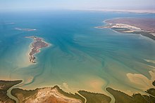
838:
Jones, Diana S. (2004). "The Burrup
Peninsula and Dampier Archipelago, Western Australia: an introduction to the history of its discovery and study, marine habitats and their flora and fauna".
516:
Arid-climate mangroves are globally rare, and the
Pilbara Coast has some of the largest areas of arid-climate mangrove on the planet. The Pilbara Coast is home to five species of mangrove –
556:, and the Rosily islands. The lower turbidity allows for abundant corals, which form fringing reefs and sustain a diverse coral reef flora and fauna, including many endemic species.
747:
Coasts and Ports 2011: Diverse and
Developing: Proceedings of the 20th Australasian Coastal and Ocean Engineering Conference and the 13th Australasian Port and Harbour Conference
544:. Many birds, fishes, and invertebrates live in the mangroves. The intertidal mud flats are home to abundant burrowing invertebrates, which sustain migratory and resident birds.
368:
74:
441:
Cenozoic aeolian and beach rock deposits are common along the entire coastline. The western portion of the coast, from North West Cape to Cape
Preston including
880:
676:
693:
480:
The sea floor slopes gently away from the coast, and the 10-metre bathymetric contour is generally between 1 and 2 miles offshore. The waters are
754:
875:
492:
411:
431:
406:
Lagoons protected by barrier islands, embayments, river deltas, and rocky headlands are the main coastal features. The
Pilbara's
817:"Climatology of Tropical Cyclones in Western Australia" Bureau of Meteorology, Government of Australia. Accessed 19 July 2021.
713:
660:
241:
177:
257:
209:
745:
Taylor, David; Branson, Paul; Treloar, Doug (2011), "Monte Carlo cyclone track model system for the
Pilbara coast",
628:
620:
608:
111:
624:
225:
870:
671:
522:
496:
426:, have deposited sediment to form river deltas. There are many coastal islands, including the near-shore
644:
565:
449:
formation. The eastern portion from Cape Preston to Cape Keraudren is near the northern margin of the
530:
57:
666:
577:
518:
427:
648:
540:
435:
407:
93:
750:
396:
89:
49:
553:
549:
526:
852:
446:
415:
384:
373:
193:
450:
392:
359:
864:
814:
688:
534:
423:
310:
640:
469:
442:
274:
160:
37:
468:
In Bureau of Meteorology reports, Pilbara Coast West runs from North West Cape to
826:
419:
292:
643:. Dampier is an industrial port which exports iron ore from the interior and
17:
636:
612:
589:
581:
569:
512:
430:, a cluster of rocky islands and reefs. The larger offshore islands include
632:
585:
127:
770:
573:
63:
It is a complex array of river mouths, ports, peninsulas, and islands.
53:
32:
597:
593:
481:
400:
377:
143:
727:
663:
and Marine Protected Area protect the eastern portion of the coast.
607:
508:
491:
388:
343:
327:
31:
851:"Map of Indigenous Australia". AIATSIS. Accessed 20 July 2021.
568:
peoples of the Pilbara Coast include, from west to east, the
387:
forms the western end of the Pilbara Coast. According to the
472:, and Pilbara Coast East is from Cape Preston to Wallal.
651:. Port Hedland's industrial port also exports iron ore.
853:
https://aiatsis.gov.au/explore/map-indigenous-australia
815:http://www.bom.gov.au/cyclone/climatology/wa.shtml
395:, a rocky headland that forms the western end of
619:Settlements on the coast include the towns of
8:
827:http://www.bom.gov.au/wa/forecasts/map.shtml
800:
798:
796:
794:
792:
790:
788:
840:Records of the Western Australian Museum
677:Great Sandy Island Marine Protected Area
705:
461:The climate is tropical and semi-arid.
186:
56:region. It is often referred to as the
352:
772:Discovering the central Pilbara coast
302:
7:
769:Pilbara Tourism Association (2002),
714:"Tour | Australia's North West"
266:
152:
81:
445:, is underlain by the sedimentary
284:
25:
881:Biogeography of Western Australia
234:
170:
36:Gales Bay at the southern end of
842:Supplement No. 66: 27–49 (2004).
749:, Engineers Australia: 712–718,
399:. Others end it further east at
351:
335:
319:
301:
283:
265:
250:
249:
233:
217:
202:
201:
185:
169:
151:
135:
120:
119:
103:
80:
73:
829:Western Australian Forecast Map
104:
218:
136:
27:Coastline of Western Australia
1:
661:Eighty Mile Beach Marine Park
372:The Pilbara Coast is between
336:
320:
391:, the Pilbara Coast ends at
876:IMCRA meso-scale bioregions
897:
649:Greater Gorgon gas field
503:) on the Pilbara Coast.
672:Montebello Marine Park
616:
523:Aegiceras corniculatum
511:system designates two
504:
497:Black-fronted dotterel
60:of Western Australia.
41:
645:liquified natural gas
611:
566:Australian Aboriginal
495:
35:
531:Bruguiera exaristata
369:class=notpageimage|
48:is the coastline of
732:pilbaraports.com.au
667:Dampier Marine Park
519:Aegialitis annulata
501:Elseyornis melanops
428:Dampier Archipelago
408:intermittent rivers
647:from the offshore
617:
560:Aboriginal peoples
541:Rhizophora stylosa
505:
436:Montebello Islands
42:
756:978-0-85825-886-0
397:Eighty Mile Beach
50:Western Australia
16:(Redirected from
888:
855:
849:
843:
836:
830:
824:
818:
812:
806:
802:
783:
782:
781:
779:
766:
760:
759:
742:
736:
735:
724:
718:
717:
710:
527:Avicennia marina
410:, including the
355:
354:
339:
338:
323:
322:
313:
305:
304:
295:
287:
286:
277:
269:
268:
253:
252:
237:
236:
221:
220:
205:
204:
189:
188:
173:
172:
163:
155:
154:
139:
138:
123:
122:
107:
106:
97:
84:
83:
77:
58:North West Coast
21:
896:
895:
891:
890:
889:
887:
886:
885:
861:
860:
859:
858:
850:
846:
837:
833:
825:
821:
813:
809:
803:
786:
777:
775:
768:
767:
763:
757:
744:
743:
739:
726:
725:
721:
712:
711:
707:
702:
694:Kimberley Coast
685:
657:
655:Protected areas
606:
562:
490:
478:
459:
447:Carnarvon Basin
385:North West Cape
382:
381:
380:
374:North West Cape
371:
365:
364:
363:
362:
356:
348:
347:
346:
340:
332:
331:
330:
324:
316:
315:
314:
309:
306:
298:
297:
296:
291:
288:
280:
279:
278:
273:
270:
262:
261:
260:
254:
246:
245:
244:
238:
230:
229:
228:
222:
214:
213:
212:
206:
198:
197:
196:
194:North West Cape
190:
182:
181:
180:
174:
166:
165:
164:
159:
156:
148:
147:
146:
140:
132:
131:
130:
124:
116:
115:
114:
108:
100:
99:
98:
88:
85:
69:
28:
23:
22:
15:
12:
11:
5:
894:
892:
884:
883:
878:
873:
863:
862:
857:
856:
844:
831:
819:
807:
784:
761:
755:
737:
719:
704:
703:
701:
698:
697:
696:
691:
684:
681:
680:
679:
674:
669:
664:
656:
653:
605:
602:
561:
558:
489:
486:
477:
474:
458:
455:
451:Pilbara Craton
393:Cape Keraudren
367:
366:
360:Cape Keraudren
358:
357:
350:
349:
342:
341:
334:
333:
326:
325:
318:
317:
308:
307:
300:
299:
290:
289:
282:
281:
272:
271:
264:
263:
256:
255:
248:
247:
240:
239:
232:
231:
224:
223:
216:
215:
208:
207:
200:
199:
192:
191:
184:
183:
176:
175:
168:
167:
158:
157:
150:
149:
142:
141:
134:
133:
126:
125:
118:
117:
110:
109:
102:
101:
87:
86:
79:
78:
72:
71:
70:
68:
65:
26:
24:
14:
13:
10:
9:
6:
4:
3:
2:
893:
882:
879:
877:
874:
872:
871:Pilbara Coast
869:
868:
866:
854:
848:
845:
841:
835:
832:
828:
823:
820:
816:
811:
808:
801:
799:
797:
795:
793:
791:
789:
785:
774:
773:
765:
762:
758:
752:
748:
741:
738:
733:
729:
723:
720:
715:
709:
706:
699:
695:
692:
690:
689:Batavia Coast
687:
686:
682:
678:
675:
673:
670:
668:
665:
662:
659:
658:
654:
652:
650:
646:
642:
638:
634:
630:
626:
622:
614:
610:
603:
601:
599:
595:
591:
587:
583:
579:
575:
571:
567:
559:
557:
555:
551:
545:
543:
542:
537:
536:
535:Ceriops tagal
532:
528:
524:
520:
514:
510:
502:
498:
494:
487:
485:
483:
475:
473:
471:
466:
462:
456:
454:
452:
448:
444:
439:
437:
433:
432:Barrow Island
429:
425:
421:
417:
413:
409:
404:
402:
398:
394:
390:
386:
379:
375:
370:
361:
345:
329:
312:
311:Israelite Bay
294:
276:
259:
243:
227:
211:
195:
179:
162:
145:
129:
113:
95:
91:
76:
66:
64:
61:
59:
55:
51:
47:
46:Pilbara Coast
39:
34:
30:
19:
18:Pilbara coast
847:
839:
834:
822:
810:
805:Environment.
776:, retrieved
771:
764:
746:
740:
731:
722:
708:
641:Port Hedland
618:
578:Martuthunira
563:
546:
539:
517:
507:Australia's
506:
500:
479:
476:Oceanography
470:Cape Preston
467:
463:
460:
443:Exmouth Gulf
440:
405:
383:
275:Cape Leeuwin
161:Cape Preston
62:
45:
43:
38:Exmouth Gulf
29:
778:14 December
604:Settlements
865:Categories
700:References
615:Courthouse
513:bioregions
293:Bremer Bay
637:Roebourne
613:Roebourne
590:Kariyarra
582:Yapurarra
570:Thalanyji
554:Thevenard
550:Bessieres
416:Fortescue
412:Ashburton
242:Fremantle
178:Carnarvon
67:Geography
683:See also
633:Karratha
586:Ngarluma
434:and the
258:Mandurah
210:Kalbarri
128:Kuri Bay
629:Dampier
621:Exmouth
574:Nhuwala
488:Ecology
457:Climate
424:De Grey
112:Wyndham
54:Pilbara
753:
728:"Home"
639:, and
625:Onslow
598:Ngarla
596:, and
594:Nyamal
538:, and
482:turbid
422:, and
401:Wallal
378:Wallal
226:Jurien
144:Wallal
96:border
509:IMCRA
389:ICMRA
344:Eucla
328:Eucla
780:2015
751:ISBN
564:The
420:Yule
376:and
44:The
529:,
52:'s
867::
787:^
730:.
635:,
631:,
627:,
623:,
600:.
592:,
588:,
584:,
580:,
576:,
572:,
552:,
533:,
525:,
521:,
438:.
418:,
414:,
403:.
94:NT
90:WA
734:.
716:.
499:(
92:/
40:.
20:)
Text is available under the Creative Commons Attribution-ShareAlike License. Additional terms may apply.