136:
457:
481:
29:
176:
143:
493:
169:
469:
505:
445:. On a busy weekend the trails will see 300-400 visitors per day. It is a popular hike for locals and those in training to climb Mt. Rainier. The summit is tree-covered so there are no views, but remnants of the concrete footings for the lookout are still there, as well as a USGS benchmark. There are budgeted plans for rebuilding the lookout so that there will again be views from the top.
400:). As a result, the west side of the Cascades experiences high precipitation, especially during the winter months in the form of snowfall. During winter months, weather is usually cloudy, but, due to high pressure systems over the Pacific Ocean that intensify during summer months, there is often little or no cloud cover during the summer. Precipitation
440:
The 256 acre
Pinnacle Peak is encompassed by the 334 acre Pinnacle Peak Park. The steep, forested, one mile Cal Magnusson Trail is located on the north side of the peak. The south slope trail has more parking and more gradual grade along a gravel road and trail, with a couple views looking south to
91:
396:. As fronts approach, they are forced upward by the peaks of the Cascade Range, causing them to drop their moisture in the form of rain or snow onto the Cascades (
682:
135:
692:
456:
333:
168:
687:
677:
593:
325:
480:
428:
approximately 5,600 years ago. Some of
Pinnacle Peak is buried beneath this mudflow since the peak predates the mudflow. Extruded outcroppings of
492:
584:
662:
589:
504:
249:
360:
received some followers. A former fire lookout built on the summit was called the
Pinnacle Peak Lookout, hence the name
84:
697:
645:
405:
579:
468:
309:
305:
223:
213:
28:
64:
54:
74:
636:
Beckey, Fred W. Cascade Alpine Guide, Climbing and High Routes. Seattle, WA: Mountaineers Books, 2008.
317:
442:
264:
613:
393:
385:
420:
rising up from the flat farmlands surrounding
Enumclaw. This flat terrain was created by the
429:
421:
397:
244:
401:
230:
671:
425:
389:
373:
329:
321:
313:
237:
281:
417:
534:
364:
emerged. The one mile trail on the north side of
Pinnacle Peak is called the
106:
93:
555:
288:
269:
44:
316:
and is set at the western edge of the range, immediately south of
369:
304:, is an 1,801-foot-elevation forest-covered summit located in
392:
originating in the
Pacific Ocean travel northeast toward the
324:. There are two other Washington summits with the same name:
614:"Mount Peak (Pinnacle Peak) — Washington Trails Association"
416:
Pinnacle Peak is a 1,000-foot (300 m) extinct volcanic
432:
can be seen along the trails near the top of the peak.
280:
275:
263:
258:
243:
229:
219:
209:
201:
122:
83:
73:
63:
53:
43:
38:
21:
372:for 25 years with famed American mountain climber
368:for a long time Cascade mountaineer who worked at
550:
548:
408:which cuts below the south base of the peak.
16:Mountain in Washington (state), United States
8:
348:for Pete Chorak, an early Enumclaw settler,
334:Pinnacle Peak (Whatcom County, Washington)
18:
594:United States Department of the Interior
462:Mount Rainier seen from south side trail
326:Pinnacle Peak (Lewis County, Washington)
521:
452:
388:climate zone of western North America.
175:
142:
7:
683:Mountains of King County, Washington
529:
527:
525:
510:Long Hill seen from south side trail
585:Geographic Names Information System
332:to the south of Mount Rainier, and
486:Buckley seen from south side trail
14:
693:Cinder cones of the United States
498:The Three Sisters seen from trail
336:in North Cascades National Park.
188:Pinnacle Peak (the United States)
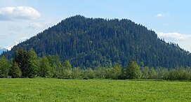
33:Pinnacle Peak seen from the north
503:
491:
479:
467:
455:
384:Pinnacle Peak is located in the
174:
167:
141:
134:
27:
688:Volcanoes of Washington (state)
678:Mountains of Washington (state)
590:United States Geological Survey
404:from the peak drains into the
158:Show map of Washington (state)
1:
191:Show map of the United States
556:"Pinnacle Peak - 1,801' WA"
535:"Pinnacle Peak, Washington"
79:3.39 mi (5.46 km)
714:
441:Mount Rainier and west to
320:and 25 miles northwest of
49:1,801 ft (549 m)
312:state. It is part of the
127:
26:
424:that spread from nearby
107:47.173663°N 121.973412°W
59:981 ft (299 m)
155:Location in Washington
112:47.173663; -121.973412
69:Radio Hill (1,950 ft)
318:Enumclaw, Washington
646:Funding for Lookout
443:Buckley, Washington
366:Cal Magnusson Trail
352:became misheard as
103: /
39:Highest point
698:Cascade Volcanoes
394:Cascade Mountains
386:marine west coast
295:
294:
705:
663:weather forecast
649:
643:
637:
634:
628:
627:
625:
624:
610:
604:
603:
601:
600:
576:
570:
569:
567:
566:
552:
543:
542:
531:
507:
495:
483:
471:
459:
300:, also known as
284:
233:
192:
178:
177:
171:
159:
145:
144:
138:
118:
117:
115:
114:
113:
108:
104:
101:
100:
99:
96:
31:
19:
713:
712:
708:
707:
706:
704:
703:
702:
668:
667:
658:
653:
652:
648:King County.gov
644:
640:
635:
631:
622:
620:
612:
611:
607:
598:
596:
580:"Pinnacle Peak"
578:
577:
573:
564:
562:
560:listsofjohn.com
554:
553:
546:
533:
532:
523:
518:
511:
508:
499:
496:
487:
484:
475:
472:
463:
460:
451:
438:
430:columnar basalt
422:Osceola Mudflow
414:
398:Orographic lift
382:
356:, and the name
342:
282:
231:
197:
196:
195:
194:
193:
190:
189:
186:
185:
184:
183:
179:
162:
161:
160:
157:
156:
153:
152:
151:
150:
146:
111:
109:
105:
102:
97:
94:
92:
90:
89:
34:
17:
12:
11:
5:
711:
709:
701:
700:
695:
690:
685:
680:
670:
669:
666:
665:
661:Pinnacle Peak
657:
656:External links
654:
651:
650:
638:
629:
605:
571:
544:
539:Peakbagger.com
520:
519:
517:
514:
513:
512:
509:
502:
500:
497:
490:
488:
485:
478:
476:
474:Pinnacle Peak
473:
466:
464:
461:
454:
450:
447:
437:
434:
413:
410:
390:Weather fronts
381:
378:
341:
338:
293:
292:
286:
278:
277:
273:
272:
267:
261:
260:
256:
255:
247:
241:
240:
235:
227:
226:
221:
217:
216:
211:
207:
206:
203:
199:
198:
187:
181:
180:
173:
172:
166:
165:
164:
163:
154:
148:
147:
140:
139:
133:
132:
131:
130:
129:
128:
125:
124:
120:
119:
87:
81:
80:
77:
71:
70:
67:
61:
60:
57:
51:
50:
47:
41:
40:
36:
35:
32:
24:
23:
15:
13:
10:
9:
6:
4:
3:
2:
710:
699:
696:
694:
691:
689:
686:
684:
681:
679:
676:
675:
673:
664:
660:
659:
655:
647:
642:
639:
633:
630:
619:
615:
609:
606:
595:
591:
587:
586:
581:
575:
572:
561:
557:
551:
549:
545:
540:
536:
530:
528:
526:
522:
515:
506:
501:
494:
489:
482:
477:
470:
465:
458:
453:
448:
446:
444:
435:
433:
431:
427:
426:Mount Rainier
423:
419:
411:
409:
407:
403:
399:
395:
391:
387:
379:
377:
375:
374:Jim Whittaker
371:
367:
363:
362:Pinnacle Peak
359:
355:
351:
347:
344:First called
339:
337:
335:
331:
330:Tatoosh Range
327:
323:
322:Mount Rainier
319:
315:
314:Cascade Range
311:
307:
303:
299:
298:Pinnacle Peak
290:
287:
285:
283:Easiest route
279:
274:
271:
268:
266:
262:
257:
254:
251:
248:
246:
242:
239:
238:Cascade Range
236:
234:
228:
225:
222:
218:
215:
212:
208:
205:United States
204:
200:
182:Pinnacle Peak
170:
149:Pinnacle Peak
137:
126:
121:
116:
88:
86:
82:
78:
76:
72:
68:
66:
62:
58:
56:
52:
48:
46:
42:
37:
30:
25:
22:Pinnacle Peak
20:
641:
632:
621:. Retrieved
617:
608:
597:. Retrieved
583:
574:
563:. Retrieved
559:
538:
439:
415:
383:
365:
361:
357:
353:
349:
345:
343:
301:
297:
296:
265:Type of rock
252:
232:Parent range
618:www.wta.org
418:cinder cone
406:White River
306:King County
110: /
98:121°58′24″W
85:Coordinates
65:Parent peak
672:Categories
623:2018-08-27
599:2018-08-21
565:2021-04-03
516:References
358:Mount Peak
346:Mount Pete
310:Washington
302:Mount Peak
214:Washington
95:47°10′25″N
55:Prominence
123:Geography
75:Isolation
45:Elevation
276:Climbing
253:Enumclaw
245:Topo map
449:Gallery
412:Geology
380:Climate
340:History
328:in the
259:Geology
202:Country
436:Hiking
402:runoff
289:Hiking
270:Basalt
220:County
291:trail
210:State
354:Peak
350:Pete
250:USGS
224:King
370:REI
308:of
674::
616:.
592:,
588:.
582:.
558:.
547:^
537:.
524:^
376:.
626:.
602:.
568:.
541:.
Text is available under the Creative Commons Attribution-ShareAlike License. Additional terms may apply.