50:
740:
398:
The community's age distribution is 22.1% under the age of 18, 7.3% from 18 to 24, 29.3% from 25 to 44, 28.6% from 45 to 64, and 12.7% who were 65 years of age or older. The median age was 40 years. For every 100 females, there were 93.6 males. For every 100 females age 18 and over, there were 92.5
394:
living together, 9.2% had a female householder with no husband present, and 23.6% were non-families. 20.9% of all households were made up of individuals, and 7.0% had someone living alone who was 65 years of age or older. The average household size was 2.47 and the average family size was 2.85.
457:
It is also home to what is locally known as the Gazebo, a public theater where performances, pageants, and other community events are held. It has also been holding a town reunion for nearly 70 years. Most recently, in 2016, a public fair was held in the town. Every year, on
Christmas Eve, a
458:
Christmas parade is held where community members will drive along the Main Street of town at dusk, most notably, the
Volunteer Fire Department. A historical resale building on the Main Street of town has a cannon in front of the building. .
49:
440:
Kanawha Valley
Regional Transportation Authority or KRT provides bus services north through Pinch to Elkview and Clendenin or South through Pinch to Charleston, and from there to several other places throughout the Kanawha Valley.
1711:
343:, the Pinch CDP has a total area of 3.6 square miles (9.3 km), of which 3.5 square miles (9.2 km) is land and 0.04 square mile (0.1 km) (1.13%) is water.
640:
1721:
359:
was 801.4 people per square mile (309.2/km). There were 1,194 housing units at an average density of 340.4/sq mi (131.3/km). The racial makeup of the community was 99.22%
402:
The median income for a Pinch household is $ 46,516, and the median income for a family was $ 55,848. Males had a median income of $ 40,456 versus $ 35,203 for females. The
1716:
1485:
1200:
1160:
633:
1365:
1205:
421:
1540:
1475:
1240:
253:
1600:
1275:
1078:
626:
71:
1658:
1630:
1590:
1520:
263:
308:
125:
618:
204:
729:
563:
364:
1580:
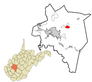
650:
477:
368:
283:
130:
55:
1681:
1640:
1575:
1285:
1270:
1165:
1430:
1145:
958:
586:
538:
510:
481:
376:
340:
1455:
1380:
1355:
1350:
1230:
1058:
1003:
938:
903:
893:
838:
833:
818:
764:
1560:
1480:
1470:
1420:
1345:
1335:
1300:
1255:
1220:
1124:
1104:
1094:
1053:
1038:
978:
888:
858:
812:
769:
718:
706:
691:
672:
1635:
1625:
1515:
1260:
1185:
1170:
1129:
1109:
1083:
1028:
993:
963:
868:
863:
828:
779:
774:
241:
103:
390:
There were 1,138 households, out of which 32.5% had children under the age of 18 living with them, 64.7% were
1615:
1595:
1550:
1530:
1510:
1505:
1465:
1460:
1440:
1425:
1415:
1400:
1395:
1375:
1305:
1235:
1225:
1155:
1114:
1099:
1023:
998:
968:
853:
804:
723:
588:
West
Virginia Place Names: Their Origin and Meaning, Including the Nomenclature of the Streams and Mountains
294:
279:
39:
602:
1570:
1385:
1360:
1330:
1315:
1295:
1280:
1215:
1150:
1088:
983:
948:
898:
848:
843:
823:
789:
784:
380:
17:
1620:
1585:
1565:
1545:
1535:
1525:
1495:
1450:
1435:
1410:
1340:
1290:
1265:
1210:
1180:
1140:
1134:
1068:
1043:
1013:
1008:
973:
943:
923:
873:
701:
696:
1688:
1490:
1445:
1405:
1390:
1370:
1310:
1250:
1245:
1195:
1190:
1175:
1063:
1048:
1018:
988:
953:
794:
759:
751:
712:
683:
384:
214:
1610:
1605:
1500:
1325:
1320:
1073:
1033:
933:
928:
913:
883:
449:
Pinch is home of Indian Lake, a man-made lake specifically created for fishing. It is stocked with
372:
360:
355:
of 2000, there were 2,811 people, 1,138 households, and 869 families living in the community. The
1555:
1119:
356:
403:
454:
406:
in Pinch is $ 21,398. About 6.0% of families and 5.9% of the population were below the
1705:
450:
287:
246:
118:
59:
407:
665:
1650:
113:
323:
310:
86:
73:
195:
410:, including 5.5% of those under age 18 and 19.9% of those age 65 or over.
1672:‡This populated place also has portions in an adjacent county or counties
391:
229:
506:
352:
432:
Saint Andrew
Nursery School provides WV Pre-K preschool services.
221:
200:
622:
290:, United States. The population was 3,262 at the 2010 census.
738:
559:
1712:
Census-designated places in
Kanawha County, West Virginia
534:
25:
Census-designated place in West
Virginia, United States
418:
The following public schools service the Pinch area:
1667:
1649:
912:
803:
750:
682:
262:
252:
240:
228:
211:
194:
186:
178:
173:
165:
157:
149:
141:
136:
124:
112:
102:
30:
591:. Piedmont, WV: The Place Name Press. p. 489.
634:
8:
1722:Charleston, West Virginia metropolitan area
739:
641:
627:
619:
478:"US Gazetteer files: 2010, 2000, and 1990"
387:of any race were 0.50% of the population.
27:
1717:Census-designated places in West Virginia
466:
251:
227:
193:
172:
164:
135:
101:
66:
46:
529:
527:
501:
499:
472:
470:
293:The community was named after nearby
261:
239:
210:
185:
177:
156:
148:
140:
123:
111:
7:
379:, and 0.32% from two or more races.
649:Municipalities and communities of
161:0.04 sq mi (0.1 km)
14:
153:3.5 sq mi (9.2 km)
145:3.6 sq mi (9.3 km)
48:
564:United States Geological Survey
560:"US Board on Geographic Names"
1:
652:Kanawha County, West Virginia
539:United States Census Bureau
511:United States Census Bureau
482:United States Census Bureau
341:United States Census Bureau
1738:
422:Herbert Hoover High School
15:
1677:
736:
663:
603:"West Virginia Pay Lakes"
336:(38.406348, -81.484682).
67:
47:
37:
429:Pinch Elementary School
169:715 ft (218 m)
280:census-designated place
190:980/sq mi (380/km)
40:Census-designated place
744:
585:Kenny, Hamill (1945).
426:Elkview Middle School
18:Pinch (disambiguation)
742:
535:"U.S. Census website"
507:"U.S. Census website"
436:Public Transportation
324:38.40639°N 81.48472°W
213: • Summer (
87:38.40639°N 81.48472°W
1690:United States portal
1683:West Virginia portal
305:Pinch is located at
187: • Density
32:Pinch, West Virginia
16:For other uses, see
484:. February 12, 2011
329:38.40639; -81.48472
320: /
92:38.40639; -81.48472
83: /
745:
743:Kanawha County map
566:. October 25, 2007
445:Places of interest
357:population density
179: • Total
158: • Water
142: • Total
1699:
1698:
1486:Rock Lake Village
404:per capita income
339:According to the
273:
272:
150: • Land
1729:
1691:
1684:
741:
730:South Charleston
675:
668:
658:
653:
643:
636:
629:
620:
614:
613:
611:
609:
599:
593:
592:
582:
576:
575:
573:
571:
556:
550:
549:
547:
545:
531:
522:
521:
519:
517:
503:
494:
493:
491:
489:
474:
365:African American
335:
334:
332:
331:
330:
325:
321:
318:
317:
316:
313:
218:
98:
97:
95:
94:
93:
88:
84:
81:
80:
79:
76:
52:
28:
1737:
1736:
1732:
1731:
1730:
1728:
1727:
1726:
1702:
1701:
1700:
1695:
1689:
1682:
1673:
1663:
1645:
915:
908:
799:
746:
734:
678:
673:
666:
659:
656:
651:
647:
617:
607:
605:
601:
600:
596:
584:
583:
579:
569:
567:
558:
557:
553:
543:
541:
533:
532:
525:
515:
513:
505:
504:
497:
487:
485:
476:
475:
468:
464:
455:channel catfish
447:
438:
416:
392:married couples
369:Native American
349:
328:
326:
322:
319:
314:
311:
309:
307:
306:
303:
236:
212:
91:
89:
85:
82:
77:
74:
72:
70:
69:
63:
43:
33:
26:
21:
12:
11:
5:
1735:
1733:
1725:
1724:
1719:
1714:
1704:
1703:
1697:
1696:
1694:
1693:
1686:
1678:
1675:
1674:
1671:
1669:
1665:
1664:
1662:
1661:
1655:
1653:
1647:
1646:
1644:
1643:
1638:
1633:
1628:
1623:
1618:
1613:
1608:
1603:
1598:
1593:
1588:
1583:
1581:Tyler Mountain
1578:
1573:
1568:
1563:
1558:
1553:
1548:
1543:
1538:
1533:
1528:
1523:
1518:
1513:
1508:
1503:
1498:
1493:
1488:
1483:
1478:
1473:
1468:
1463:
1458:
1453:
1448:
1443:
1438:
1433:
1428:
1423:
1418:
1413:
1408:
1403:
1398:
1393:
1388:
1383:
1378:
1373:
1368:
1363:
1358:
1353:
1348:
1343:
1338:
1333:
1328:
1323:
1318:
1313:
1308:
1303:
1298:
1293:
1288:
1283:
1278:
1273:
1268:
1263:
1258:
1253:
1248:
1243:
1238:
1233:
1228:
1223:
1218:
1213:
1208:
1203:
1198:
1193:
1188:
1183:
1178:
1173:
1168:
1163:
1158:
1153:
1148:
1143:
1138:
1132:
1127:
1122:
1117:
1112:
1107:
1102:
1097:
1092:
1086:
1081:
1076:
1071:
1066:
1061:
1056:
1051:
1046:
1041:
1036:
1031:
1026:
1021:
1016:
1011:
1006:
1001:
996:
991:
986:
981:
976:
971:
966:
961:
956:
951:
946:
941:
936:
931:
926:
920:
918:
910:
909:
907:
906:
901:
896:
891:
886:
881:
876:
871:
866:
861:
856:
851:
846:
841:
836:
831:
826:
821:
816:
809:
807:
801:
800:
798:
797:
792:
787:
782:
777:
772:
767:
762:
756:
754:
748:
747:
737:
735:
733:
732:
727:
721:
716:
710:
704:
699:
694:
688:
686:
680:
679:
664:
661:
660:
648:
646:
645:
638:
631:
623:
616:
615:
594:
577:
551:
523:
495:
465:
463:
460:
446:
443:
437:
434:
415:
414:Public Schools
412:
348:
345:
302:
299:
284:Kanawha County
271:
270:
267:
260:
259:
256:
250:
249:
244:
238:
237:
234:
232:
226:
225:
219:
209:
208:
198:
192:
191:
188:
184:
183:
180:
176:
175:
171:
170:
167:
163:
162:
159:
155:
154:
151:
147:
146:
143:
139:
138:
134:
133:
128:
122:
121:
116:
110:
109:
106:
100:
99:
65:
64:
56:Kanawha County
53:
45:
44:
38:
35:
34:
31:
24:
13:
10:
9:
6:
4:
3:
2:
1734:
1723:
1720:
1718:
1715:
1713:
1710:
1709:
1707:
1692:
1687:
1685:
1680:
1679:
1676:
1670:
1666:
1660:
1657:
1656:
1654:
1652:
1648:
1642:
1641:Youngs Bottom
1639:
1637:
1634:
1632:
1629:
1627:
1624:
1622:
1619:
1617:
1614:
1612:
1609:
1607:
1604:
1602:
1599:
1597:
1594:
1592:
1589:
1587:
1584:
1582:
1579:
1577:
1576:Tyler Heights
1574:
1572:
1569:
1567:
1564:
1562:
1559:
1557:
1554:
1552:
1549:
1547:
1544:
1542:
1539:
1537:
1534:
1532:
1529:
1527:
1524:
1522:
1519:
1517:
1514:
1512:
1509:
1507:
1504:
1502:
1499:
1497:
1494:
1492:
1489:
1487:
1484:
1482:
1479:
1477:
1474:
1472:
1469:
1467:
1464:
1462:
1459:
1457:
1454:
1452:
1449:
1447:
1444:
1442:
1439:
1437:
1434:
1432:
1429:
1427:
1424:
1422:
1419:
1417:
1414:
1412:
1409:
1407:
1404:
1402:
1399:
1397:
1394:
1392:
1389:
1387:
1384:
1382:
1379:
1377:
1374:
1372:
1369:
1367:
1364:
1362:
1359:
1357:
1354:
1352:
1349:
1347:
1344:
1342:
1339:
1337:
1334:
1332:
1329:
1327:
1324:
1322:
1319:
1317:
1314:
1312:
1309:
1307:
1304:
1302:
1299:
1297:
1294:
1292:
1289:
1287:
1286:Jarretts Ford
1284:
1282:
1279:
1277:
1274:
1272:
1271:Island Branch
1269:
1267:
1264:
1262:
1259:
1257:
1254:
1252:
1249:
1247:
1244:
1242:
1239:
1237:
1234:
1232:
1229:
1227:
1224:
1222:
1219:
1217:
1214:
1212:
1209:
1207:
1204:
1202:
1199:
1197:
1194:
1192:
1189:
1187:
1184:
1182:
1179:
1177:
1174:
1172:
1169:
1167:
1166:Forks of Coal
1164:
1162:
1159:
1157:
1154:
1152:
1149:
1147:
1144:
1142:
1139:
1136:
1133:
1131:
1128:
1126:
1123:
1121:
1118:
1116:
1113:
1111:
1108:
1106:
1103:
1101:
1098:
1096:
1093:
1090:
1087:
1085:
1082:
1080:
1077:
1075:
1072:
1070:
1067:
1065:
1062:
1060:
1057:
1055:
1052:
1050:
1047:
1045:
1042:
1040:
1037:
1035:
1032:
1030:
1027:
1025:
1022:
1020:
1017:
1015:
1012:
1010:
1007:
1005:
1002:
1000:
997:
995:
992:
990:
987:
985:
982:
980:
977:
975:
972:
970:
967:
965:
962:
960:
957:
955:
952:
950:
947:
945:
942:
940:
937:
935:
932:
930:
927:
925:
922:
921:
919:
917:
911:
905:
902:
900:
897:
895:
892:
890:
887:
885:
882:
880:
877:
875:
872:
870:
867:
865:
862:
860:
857:
855:
852:
850:
847:
845:
842:
840:
837:
835:
832:
830:
827:
825:
822:
820:
817:
814:
811:
810:
808:
806:
802:
796:
793:
791:
788:
786:
783:
781:
778:
776:
773:
771:
768:
766:
763:
761:
758:
757:
755:
753:
749:
731:
728:
725:
722:
720:
717:
714:
711:
708:
705:
703:
700:
698:
695:
693:
690:
689:
687:
685:
681:
677:
676:
669:
662:
657:United States
654:
644:
639:
637:
632:
630:
625:
624:
621:
604:
598:
595:
590:
589:
581:
578:
565:
561:
555:
552:
540:
536:
530:
528:
524:
512:
508:
502:
500:
496:
483:
479:
473:
471:
467:
461:
459:
456:
452:
451:rainbow trout
444:
442:
435:
433:
430:
427:
424:
423:
419:
413:
411:
409:
405:
400:
396:
393:
388:
386:
382:
378:
375:, 0.07% from
374:
370:
366:
362:
358:
354:
346:
344:
342:
337:
333:
300:
298:
296:
291:
289:
288:West Virginia
285:
281:
277:
268:
265:
257:
255:
248:
245:
243:
233:
231:
223:
220:
216:
206:
205:Eastern (EST)
202:
199:
197:
189:
181:
168:
160:
152:
144:
132:
129:
127:
120:
119:West Virginia
117:
115:
108:United States
107:
105:
96:
68:Coordinates:
61:
60:West Virginia
58:and state of
57:
51:
41:
36:
29:
23:
19:
1431:Port Amherst
1201:Green Valley
1161:Forest Hills
1146:Falling Rock
959:Barren Creek
878:
671:
606:. Retrieved
597:
587:
580:
568:. Retrieved
554:
542:. Retrieved
514:. Retrieved
486:. Retrieved
448:
439:
431:
428:
425:
420:
417:
408:poverty line
401:
397:
389:
350:
347:Demographics
338:
304:
292:
275:
274:
54:Location in
22:
1651:Ghost towns
1456:Red Warrior
1381:Mink Shoals
1366:Meadowbrook
1356:Lower Falls
1351:Lower Belle
1231:Hicumbottom
1206:Greencastle
1059:Davis Creek
1004:Cabin Creek
939:Amandaville
916:communities
904:West Dunbar
894:Sissonville
839:Dupont City
834:Cross Lanes
819:Big Chimney
765:Cedar Grove
667:County seat
608:October 31,
570:January 31,
544:January 31,
377:other races
327: /
295:Pinch Creek
90: /
1706:Categories
1561:Three Mile
1481:Rocky Fork
1471:River Bend
1421:Pocatalico
1346:Loudendale
1336:Livingston
1301:Kelly Hill
1256:Hollyhurst
1221:Heatherman
1125:Elk Forest
1105:East Nitro
1095:Dry Branch
1054:Crown Hill
1039:Copenhaver
979:Blue Creek
889:Shrewsbury
859:Hollygrove
813:Alum Creek
770:Chesapeake
719:St. Albans
707:Montgomery
692:Charleston
674:Charleston
462:References
351:As of the
312:38°24′23″N
266:feature ID
174:Population
75:38°24′23″N
1668:Footnotes
1636:Winifrede
1626:Whittaker
1541:Snow Hill
1516:Sanderson
1476:Riverside
1261:Hugheston
1241:Hillsdale
1186:Gallagher
1171:Fort Hill
1130:Elk Hills
1110:East Side
1084:Dickinson
1029:Coalridge
994:Brounland
964:Blackhawk
869:Jefferson
864:Institute
829:Coal Fork
780:East Bank
775:Clendenin
516:April 26,
488:April 23,
315:81°29′5″W
301:Geography
282:(CDP) in
254:FIPS code
242:Area code
196:Time zone
166:Elevation
78:81°29′5″W
1616:Wellford
1596:Walgrove
1551:Standard
1531:Schrader
1511:Rutledge
1506:Ruthdale
1466:Republic
1461:Rensford
1441:Quarrier
1426:Pond Gap
1416:Pentacre
1401:Nuckolls
1396:Notomine
1376:Milliken
1306:Kendalia
1236:Highlawn
1226:Hernshaw
1156:Fivemile
1115:Edgewood
1100:Dungriff
1024:Coalburg
999:Burnwell
969:Blakeley
854:Hansford
724:Smithers
381:Hispanic
371:, 0.04%
367:, 0.21%
363:, 0.14%
258:54-63772
230:ZIP code
1601:Wallace
1571:Twomile
1386:Monarch
1361:Mammoth
1331:Lincoln
1316:Leewood
1296:Kayford
1281:Jarrett
1276:Ivydale
1216:Guthrie
1151:Ferrell
1089:Donwood
1079:Diamond
984:Blundon
949:Annfred
899:Tornado
849:Eskdale
844:Elkview
824:Chelyan
790:Handley
785:Glasgow
399:males.
269:1544859
131:Kanawha
104:Country
1659:Morris
1631:Wilson
1621:Wevaco
1591:Victor
1586:United
1566:Turner
1546:Sproul
1536:Sharon
1526:Sattes
1496:Rosina
1451:Reamer
1436:Putney
1411:Olcott
1341:London
1291:Joplin
1266:Indian
1211:Grippe
1181:Fuquay
1141:Etowah
1135:Emmons
1069:Decota
1044:Corton
1014:Carney
1009:Carbon
974:Blount
944:Amelia
924:Aarons
874:Malden
702:Marmet
697:Dunbar
684:Cities
385:Latino
353:census
126:County
1521:Sandy
1491:Ronda
1446:Quick
1406:Ohley
1391:Mound
1371:Miami
1311:Laing
1251:Holly
1246:Hitop
1196:Giles
1191:Gazil
1176:Frame
1064:Dawes
1049:Crede
1019:Cinco
989:Bream
954:Apgah
914:Other
879:Pinch
795:Pratt
760:Belle
752:Towns
713:Nitro
373:Asian
361:White
278:is a
276:Pinch
235:25156
224:(EDT)
222:UTC-4
201:UTC-5
182:3,538
114:State
42:(CDP)
1611:Weir
1606:Ward
1501:Ruth
1326:Lico
1321:Legg
1074:Dial
1034:Coco
934:Acup
929:Acme
884:Rand
805:CDPs
610:2010
572:2008
546:2008
518:2024
490:2011
453:and
264:GNIS
137:Area
1556:Tad
1120:Elk
383:or
247:304
215:DST
1708::
670::
655:,
562:.
537:.
526:^
509:.
498:^
480:.
469:^
297:.
286:,
1137:‡
1091:‡
815:‡
726:‡
715:‡
709:‡
642:e
635:t
628:v
612:.
574:.
548:.
520:.
492:.
217:)
207:)
203:(
62:.
20:.
Text is available under the Creative Commons Attribution-ShareAlike License. Additional terms may apply.