238:
29:
346:
320:
325:
389:
384:
233:
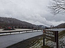
There is one lock chamber on the left descending bank of the river at the dam, 84 feet (26 m) wide and 720 feet (220 m) long. The reservoir formed by the dam is also a municipal and industrial water supply.
374:
399:
394:
404:
46:
42:
369:
250:
70:
409:
340:
379:
219:
121:
269:
50:
54:
203:
222:, the gated dam forms an upstream pool that is 11.2 miles (18.0 km) long, stretching to the base of the
223:
211:
237:
297:
199:
136:
314:
241:
Point Marion Lock and Dam
Entrance, with the Fort Martin Power Station in the distance.
172:
363:
215:
207:
58:
290:
270:"U.S. Army Corps of Engineers, Pittsburgh District- Point Marion Lock and Dam"
227:
85:
72:
273:
28:
390:
Transportation buildings and structures in
Fayette County, Pennsylvania
385:
Transportation buildings and structures in Greene County, Pennsylvania
236:
345:
319:
324:
294:
375:
United States Army Corps of
Engineers, Pittsburgh District
400:
Buildings and structures in
Fayette County, Pennsylvania
395:
Buildings and structures in Greene County, Pennsylvania
181:
171:
163:
158:
150:
142:
132:
127:
117:
109:
101:
64:
38:
21:
122:U.S. Army Corps of Engineers, Pittsburgh District
198:, is one of nine navigational structures on the
33:Looking downstream at Point Marion Lock and Dam.
8:
405:United States Army Corps of Engineers dams
291:
251:List of crossings of the Monongahela River
18:
261:
167:11,500 acre⋅ft (14,200,000 m)
16:Dam in near Point Marion, Pennsylvania
177:2,751 sq mi (7,130 km)
7:
370:Crossings of the Monongahela River
14:
344:
323:
318:
27:
341:Albert Gallatin Memorial Bridge
230:90.5 (river kilometer 145.6).
218:. Maintained and built by the
1:
306:
220:U.S. Army Corps of Engineers
426:
335:
331:Point Marion Lock and Dam
329:
309:
304:
192:Point Marion Lock and Dam
26:
22:Point Marion Lock and Dam
154:638 ft (194 m)
224:Morgantown Lock and Dam
185:704 acres (285 ha)
146:15 ft (4.6 m)
102:Construction began
410:Dams completed in 1926
242:
194:, previously known as
240:
196:Lock and Dam Number 8
86:39.72722°N 79.91083°W
380:Dams in Pennsylvania
226:. It is located at
173:Catchment area
164:Total capacity
91:39.72722; -79.91083
82: /
243:
357:
356:
352:
351:
298:Monongahela River
200:Monongahela River
189:
188:
182:Surface area
137:Monongahela River
128:Dam and spillways
110:Opening date
417:
348:
327:
322:
315:Star City Bridge
307:
292:
285:
284:
282:
281:
272:. Archived from
266:
97:
96:
94:
93:
92:
87:
83:
80:
79:
78:
75:
31:
19:
425:
424:
420:
419:
418:
416:
415:
414:
360:
359:
358:
353:
343:
339:
333:
317:
313:
300:
289:
288:
279:
277:
268:
267:
263:
258:
248:
90:
88:
84:
81:
76:
73:
71:
69:
68:
34:
17:
12:
11:
5:
423:
421:
413:
412:
407:
402:
397:
392:
387:
382:
377:
372:
362:
361:
355:
354:
350:
349:
334:
328:
305:
302:
301:
295:
287:
286:
260:
259:
257:
254:
247:
244:
187:
186:
183:
179:
178:
175:
169:
168:
165:
161:
160:
156:
155:
152:
148:
147:
144:
140:
139:
134:
130:
129:
125:
124:
119:
115:
114:
111:
107:
106:
103:
99:
98:
66:
62:
61:
40:
36:
35:
32:
24:
23:
15:
13:
10:
9:
6:
4:
3:
2:
422:
411:
408:
406:
403:
401:
398:
396:
393:
391:
388:
386:
383:
381:
378:
376:
373:
371:
368:
367:
365:
347:
342:
338:
332:
326:
321:
316:
312:
308:
303:
299:
293:
276:on 1998-12-03
275:
271:
265:
262:
255:
253:
252:
245:
239:
235:
231:
229:
225:
221:
217:
216:West Virginia
213:
209:
205:
201:
197:
193:
184:
180:
176:
174:
170:
166:
162:
157:
153:
149:
145:
141:
138:
135:
131:
126:
123:
120:
116:
112:
108:
104:
100:
95:
67:
63:
60:
56:
52:
51:Greene County
48:
44:
41:
37:
30:
25:
20:
336:
330:
310:
296:Dams of the
278:. Retrieved
274:the original
264:
249:
232:
208:Pennsylvania
195:
191:
190:
59:Pennsylvania
55:Point Marion
118:Operator(s)
89: /
65:Coordinates
49:townships,
364:Categories
337:Downstream
280:2009-03-02
256:References
228:river mile
204:Pittsburgh
77:79°54′39″W
74:39°43′38″N
47:Springhill
159:Reservoir
311:Upstream
246:See also
212:Fairmont
202:between
133:Impounds
39:Location
53:, near
43:Dunkard
151:Length
143:Height
210:and
113:1926
105:1923
366::
214:,
206:,
57:,
45:/
283:.
Text is available under the Creative Commons Attribution-ShareAlike License. Additional terms may apply.