307:, and the deletion of dam construction funding by the OMB, the project would receive non-favorable feedback from the previously-supportive TDEC and TWRA, which both recommended in reaction the TVA’s EIS that "no action" be taken to complete and develop Poor Valley Creek State Park. With the loss of the necessary federal funding and unfavorable comments from the TDEC and TWRA, the project would be shelved indefinitely, with no action having been taken on the project since 1976. In 1987, portions of Short Mountain would be developed into a
36:
221:
hydroelectricity projects. Hale would continue suggesting the need for a state park in the Poor Valley vicinity when in 1949, he was contacted by James Pope, director of the TVA. Hale would learn that the TVA since 1941, had been planning the development of a public recreation area in the Poor Valley
359:
The exact amenities and facilities that would have been offered at Poor Valley Creek State Park is unknown, but the state would agree to the construction and development of several recreational facilities following the 1973 agreement with the TVA. In the agreement, the state government would develop
350:
On-site studies performed by the TVA revealed the prominence of bass, bluegill, shiner, crappie, darter, and carp fish species in upstream Poor Valley Creek and the embayment near
Cherokee Lake. Birds known to have the site as a habitat include sandpiper, warbler, hawk, woodpecker, sparrow, and duck
338:
The Poor Valley Creek site was analyzed for ecological purposes in the TVA's EIS published in 1975. It was found to support a diverse array of vegetation and wildlife. In the site, most of the vegetation had existed prior to the impoundment of the creek by the TVA for the
Cherokee Project. Over 36
283:
would discover that this funding would never be spent by the TDEC. In May 1973, the TVA would sign an agreement with the
Tennessee state government to complete the project, having the TVA pay 80% for the construction of the lateral dam, and transfer the land and water to the state at no cost while
360:
a marina, group lodge, an environmental interpretation center, lighted tennis courts and athletic ball-fields, hiking and mountain biking trails, horse stables, a trading post/concession center, and over 50 fully-facilitated campsites and picnic areas.
208:
region were first discussed around 1945, when
Winfield Hale, the judge of Hawkins County and president of the county's chamber of commerce, suggested the idea of a public recreation area to G.L. Arsdall, who was the acting manager for the
370:
Proposals once part of the park plan but were never used in the final plans included an 18-hole golf course, a hunting preserve, and an expanded hiking trail system on an extra 4,000 acres around Short
Mountain.
288:(EIS) for the park and the dam. Around this time, the federal funding proposed by Congressman Quillen for the TVA to construct the dam would be deleted for the reportedly third time by the
323:. 1,468 of the 1,903 acres for the park would be protected forest under the ownership of the TVA, while the remaining 435 acres which consisted of privately-owned agricultural land.
669:
351:
species. Mammal species spotted included opossum, skunk, squirrel, fox, raccoon, and deer. Amphibians and reptiles spotted included frog, turtle, snake, and salamander species.
242:
141:
272:
native would support the proposals for the park and federal funding for the TVA to construct the dam on Poor Valley Creek required to maintain it at a full capacity annually.
319:
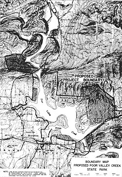
The proposed park would have been located on 1,903 acres surrounding the Poor Valley Creek watershed of
Cherokee Lake in unincorporated Hawkins County near the community of
311:
mining facility near the park site despite local controversy and opposition by residents, supporters of the state park project, and local and state government officials.
679:
173:
674:
279:
would vote to appropriate $ 50,000 in 1971 to the TDEC for initial operations of the park, equivalent to $ 376,171 in 2023. Investigations by the
265:
98:
684:
389:
254:
260:
Throughout the 1960s, the park project would go through more studies and grant-writing when a major win for the park occurred in 1963,
257:(TWRA) would report that the Poor Valley site would be most suitable as a state park rather than a hunting preserve or nature refuge.
246:
222:
region and work for a lateral dam on the Poor Valley Creek embayment of
Cherokee Lake was underway. The next year, Hale would head to
664:
367:
bridges on the creek would have made the creek into a 543 acre reservoir fit for the proposed water-based amenities for the park.
289:
285:
284:
the state would support the cost and most oversight regarding the development of the park. In 1975, the TVA would complete its
253:, and start initial surveying and studies on-site for the Poor Valley State Creek Park project. In the following year, the
327:
91:
245:(TDEC), which operates the Tennessee State Parks system, would begin discussions with Hawkins County leaders including
525:
496:
642:
599:
276:
210:
145:
41:
504:
304:
177:
66:
300:
461:
299:
After the publication of the impact statement by the TVA, and influenced by both the completion of the nearby
556:
84:
423:
293:
250:
35:
320:
561:
466:
428:
280:
269:
184:, United States. It would have been located prominently near the Poor Valley Creek embayment of
213:(TVA) firm Norris-Cherokee Properties, which maintained land owned by the TVA obtained for the
192:. The park was first planned in 1945, and shelved indefinitely following comments supporting "
326:
The Poor Valley Creek watershed is surrounded by forested shale-based mountain slopes in the
238:
227:
223:
193:
340:
308:
275:
By the 1970s, the final planning and development work of the project would start, as the
471:
364:
231:
339:
species of trees were identified in the site, with most being cove, mixed, and upland
658:
261:
189:
185:
74:
214:
593:
393:
205:
218:
56:
113:
100:
181:
70:
292:(OMB) before the funding bill for TVA-related projects reached the
234:
supporting funding and efforts for a state park in
Hawkins County.
344:
363:
A linear dam constructed by the TVA south of the site and the
639:
Poor Valley Creek State Park: Environmental Impact
Statement.
595:
Poor Valley Creek State Park: Environmental Impact
Statement
330:
province, the highest being Short Mountain at 2,651 feet.
649:
Poor Valley Creek: A Study of Development Alternatives.
395:
Poor Valley Creek: A Study of Development Alternatives
557:"30 Years Of Planning Pays Off In Hawkins Park Site"
243:
Tennessee Department of Environment and Conservation
237:
In 1957, officials from the office of then Governor
142:
Tennessee Department of Environment and Conservation
424:"The Poor Valley Park Plan - Who's Holding It Back"
159:
151:
137:
129:
90:
80:
62:
52:
23:
16:Cancelled state park in Hawkins County, Tennessee
526:"Natural Beauty Of ET Beckons To Another Park"
497:"Poor Valley State Park Proposed For E-T Area"
624:. Brice & Caldwell. 1995. pp. 56–57.
622:Now and Then : Hawkins County, Tennessee
8:
670:Protected areas of Hawkins County, Tennessee
196:" on the project by state agencies in 1976.
455:
453:
451:
449:
447:
264:would be elected as a congressman serving
20:
551:
549:
547:
417:
415:
413:
268:, which represented Hawkins County. The
680:Cancelled projects in the United States
490:
488:
380:
204:The origins of plans for a park in the
266:Tennessee's 1st congressional district
588:
586:
584:
582:
580:
460:Johnston, Sheila (October 27, 1976).
7:
462:"Poor Valley Park: The Wait Goes On"
158:
51:
675:Proposed parks in the United States
390:Economic Development Administration
255:Tennessee Wildlife Resources Agency
155:218,000 (in 1968 estimate)
40:A map of the proposed park by the
14:
651:(Wolf Management Services 1968).
226:for meetings with U.S. Senators
61:
34:
290:Office of Management and Budget
136:
128:
422:Ripley, Pam (March 10, 1976).
286:environmental impact statement
1:
495:Hodge, Tom (March 31, 1957).
328:Ridge-and-Valley Appalachians
170:Poor Valley Creek State Park
24:Poor Valley Creek State Park
573:– via Newspapers.com.
540:– via Newspapers.com.
514:– via Newspapers.com.
481:– via Newspapers.com.
440:– via Newspapers.com.
701:
685:Tennessee Valley Authority
643:Tennessee Valley Authority
600:Tennessee Valley Authority
565:. May 13, 1973. p. 8A
532:. May 12, 1957. p. 1D
398:. Wolf Management Services
277:Tennessee General Assembly
211:Tennessee Valley Authority
146:Tennessee Valley Authority
133:1,903 acres (7.70 km)
42:Tennessee Valley Authority
355:Recreation and facilities
48:
33:
28:
665:State parks of Tennessee
301:Panther Creek State Park
188:, an impoundment of the
114:36.355468°N 83.212907°W
85:Bean Station, Tennessee
294:United States Congress
530:The Knoxville Journal
119:36.355468; -83.212907
562:Kingsport Times-News
467:Kingsport Times-News
429:Kingsport Times-News
315:Geographical setting
281:Kingsport Times-News
247:state representative
110: /
501:Johnson City Press
249:Omar Robinson of
167:
166:
81:Nearest town
692:
626:
625:
618:
612:
611:
609:
607:
590:
575:
574:
572:
570:
553:
542:
541:
539:
537:
522:
516:
515:
513:
511:
492:
483:
482:
480:
478:
457:
442:
441:
439:
437:
419:
408:
407:
405:
403:
385:
228:Albert Gore, Sr.
224:Washington, D.C.
138:Operated by
125:
124:
122:
121:
120:
115:
111:
108:
107:
106:
103:
38:
29:Poor Valley Park
21:
700:
699:
695:
694:
693:
691:
690:
689:
655:
654:
635:
633:Further reading
630:
629:
620:
619:
615:
605:
603:
592:
591:
578:
568:
566:
555:
554:
545:
535:
533:
524:
523:
519:
509:
507:
494:
493:
486:
476:
474:
459:
458:
445:
435:
433:
421:
420:
411:
401:
399:
387:
386:
382:
377:
357:
336:
317:
202:
172:was a proposed
118:
116:
112:
109:
104:
101:
99:
97:
96:
44:
17:
12:
11:
5:
698:
696:
688:
687:
682:
677:
672:
667:
657:
656:
653:
652:
646:
634:
631:
628:
627:
613:
576:
543:
517:
484:
443:
409:
379:
378:
376:
373:
365:U.S. Route 11W
356:
353:
335:
332:
316:
313:
305:Hamblen County
232:Estes Kefauver
201:
198:
178:Hawkins County
165:
164:
161:
157:
156:
153:
149:
148:
139:
135:
134:
131:
127:
126:
94:
88:
87:
82:
78:
77:
67:Hawkins County
64:
60:
59:
54:
50:
49:
46:
45:
39:
31:
30:
26:
25:
15:
13:
10:
9:
6:
4:
3:
2:
697:
686:
683:
681:
678:
676:
673:
671:
668:
666:
663:
662:
660:
650:
647:
644:
640:
637:
636:
632:
623:
617:
614:
601:
597:
596:
589:
587:
585:
583:
581:
577:
564:
563:
558:
552:
550:
548:
544:
531:
527:
521:
518:
506:
503:. p. 1,
502:
498:
491:
489:
485:
473:
470:. p. 1,
469:
468:
463:
456:
454:
452:
450:
448:
444:
431:
430:
425:
418:
416:
414:
410:
397:
396:
391:
384:
381:
374:
372:
368:
366:
361:
354:
352:
348:
346:
342:
333:
331:
329:
324:
322:
314:
312:
310:
306:
302:
297:
295:
291:
287:
282:
278:
273:
271:
267:
263:
262:James Quillen
258:
256:
252:
248:
244:
240:
239:Frank Clement
235:
233:
229:
225:
220:
216:
212:
207:
199:
197:
195:
191:
190:Holston River
187:
186:Cherokee Lake
183:
179:
175:
171:
162:
154:
150:
147:
143:
140:
132:
123:
95:
93:
89:
86:
83:
79:
76:
75:United States
72:
68:
65:
58:
55:
47:
43:
37:
32:
27:
22:
19:
648:
638:
621:
616:
604:. Retrieved
594:
567:. Retrieved
560:
534:. Retrieved
529:
520:
508:. Retrieved
500:
475:. Retrieved
465:
434:. Retrieved
432:. p. 1D
427:
400:. Retrieved
394:
383:
369:
362:
358:
349:
343:, and mixed
337:
325:
318:
298:
274:
259:
236:
203:
169:
168:
18:
251:Rogersville
206:Poor Valley
176:in western
117: /
92:Coordinates
659:Categories
375:References
321:Mooresburg
241:, and the
174:state park
105:83°12′46″W
102:36°21′20″N
57:State park
341:hardwoods
270:Kingsport
194:no action
182:Tennessee
71:Tennessee
392:(1968).
215:Cherokee
152:Visitors
63:Location
606:May 14,
569:May 15,
536:May 15,
510:May 15,
477:May 15,
436:May 15,
402:May 15,
334:Ecology
200:History
163:Shelved
645:1975).
602:. 1975
309:silica
219:Norris
160:Status
388:U.S.
608:2021
571:2021
538:2021
512:2021
479:2021
438:2021
404:2021
345:pine
230:and
217:and
130:Area
53:Type
303:in
661::
598:.
579:^
559:.
546:^
528:.
505:1A
499:.
487:^
464:.
446:^
426:.
412:^
347:.
296:.
180:,
144:,
73:,
69:,
641:(
610:.
472:8
406:.
Text is available under the Creative Commons Attribution-ShareAlike License. Additional terms may apply.