874:
29:
577:
259:
307:
324:
919:
562:
415:
436:
963:
246:
word "Pontus" (Πόντος), which means "sea." The Pontic
Mountains, or Póntos Óri in Greek, stretch along the southern coast of the Black Sea, known in
145:
958:
485:
74:
528:
953:
540:
938:
912:
555:
282:(and their western extension the Akçakoca Mountains) and the Bolu Mountains, following the coast. The highest peak in the range is
943:
340:
673:
477:
905:
548:
138:
67:
571:
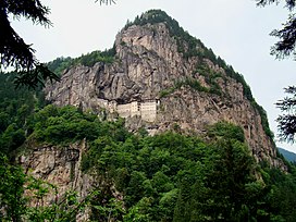
412:
948:
291:
648:
456:
803:
838:
798:
678:
367:
359:
328:
381:
Winter conditions are very harsh, and snow even in summer months isn't unusual above certain elevations.
592:
287:
828:
597:
363:
351:
344:
733:
283:
50:
823:
748:
743:
389:
332:
247:
713:
693:
833:
778:
612:
525:
481:
385:
371:
295:
279:
271:
131:
889:
881:
813:
788:
622:
227:
215:
187:
33:
773:
663:
607:
602:
532:
452:
419:
336:
818:
683:
501:
28:
758:
632:
275:
243:
199:
932:
808:
763:
738:
703:
653:
231:
873:
783:
688:
668:
627:
355:
219:
266:
The range runs roughly east–west, parallel and close to the southern coast of the
723:
718:
393:
375:
728:
708:
258:
335:. The narrow coastal strip between the mountains and the Black Sea, known as
160:
147:
89:
76:
793:
753:
267:
843:
853:
848:
658:
203:
306:
317:
316:
The mountains are generally covered by dense forests, predominantly of
310:
885:
698:
576:
432:
207:
127:
57:
388:, which lies south of the range, has a considerably drier and more
768:
305:
257:
250:
as the "Euxine Sea" or simply "Pontus
Euxinus" (Πόντος Εὔξεινος).
234:, the mountains were called the Paryadres or Parihedri Mountains.
544:
422:. See the "Parhar" (plateau) and "Parhal" (village) articles.
331:
extend across the far-eastern end of the range, known as the
327:
is an ecoregion which covers most of the range, while the
893:
392:
than the humid and mild coast, owing to the mountains'
350:
The region is home to
Eurasian wildlife such as the
286:, which rises to 3,937 m (12,917 ft). The
641:
585:
137:
123:
118:
110:
105:
66:
56:
46:
41:
21:
325:Northern Anatolian conifer and deciduous forests
242:The name of the mountains is derived from the
913:
556:
8:
262:A panorama of the Pontic Mountains in Turkey
16:Mountain range in northern Anatolia, Turkey
920:
906:
563:
549:
541:
18:
502:"File:Koppen-Geiger Map TUR present.svg"
343:, which contain some of the world's few
405:
298:, run along the length of the range.
7:
870:
868:
278:, with the northwestern spur of the
230:word meaning "high" or "summit". In
892:. You can help Knowledge (XXG) by
474:Top 100 Birding Sites of the World
14:
964:Black Sea Region geography stubs
872:
575:
341:Euxine-Colchic deciduous forests
27:
959:Important Bird Areas of Turkey
526:Pontic Mountains and highlands
478:University of California Press
294:, which are east–west-running
1:
458:Naturalis Historia (77–79 AD)
413:Karadeniz Ansiklopedik Sözlük
210:. They are also known as the
62:3,937 m (12,917 ft)
270:. It extends northeast into
438:Geographica (35 BC – 23 AD)
114:1,000 km (620 mi)
980:
954:Landforms of Rize Province
867:
939:Mountain ranges of Turkey
472:Couzens, Dominic (2008).
292:Northeast Anatolian Fault
196:North Anatolian Mountains
26:
944:Physiographic provinces
36:on the Pontic Mountains
368:Caucasian black grouse
360:eastern imperial eagle
329:Caucasus mixed forests
313:
263:
880:This article about a
506:commons.wikimedia.org
345:temperate rainforests
309:
288:North Anatolian Fault
261:
192:Kuzey Anadolu Dağları
364:lesser spotted eagle
352:Eurasian sparrowhawk
274:, and west into the
222:languages. The term
572:Mountains of Turkey
390:continental climate
157: /
86: /
679:Beşparmak (Latmus)
531:2014-02-26 at the
480:. pp. 73–75.
418:2008-05-13 at the
314:
296:strike-slip faults
264:
226:originates from a
42:Highest point
901:
900:
862:
861:
508:. 6 November 2018
487:978-0-520-25932-4
461:. p. iix.25.
386:Anatolian Plateau
372:red-fronted serin
339:, is home to the
176:
175:
161:40.500°N 40.500°E
139:Range coordinates
90:40.833°N 41.150°E
971:
949:Black Sea Region
922:
915:
908:
882:Black Sea Region
876:
869:
789:Nemrut (volcano)
580:
579:
565:
558:
551:
542:
535:
523:
517:
516:
514:
513:
498:
492:
491:
469:
463:
462:
455:. "Chapter VI".
449:
443:
442:
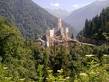
441:. p. xii.4.
435:. "Chapter XI".
429:
423:
410:
333:Kaçkar Mountains
212:Parhar Mountains
180:Pontic Mountains
172:
171:
169:
168:
167:
162:
158:
155:
154:
153:
150:
101:
100:
98:
97:
96:
91:
87:
84:
83:
82:
79:
34:Sumela Monastery
31:
22:Pontic Mountains
19:
979:
978:
974:
973:
972:
970:
969:
968:
929:
928:
927:
926:
865:
863:
858:
637:
586:Mountain ranges
581:
574:
569:
539:
538:
533:Wayback Machine
524:
520:
511:
509:
500:
499:
495:
488:
471:
470:
466:
453:Pliny the Elder
451:
450:
446:
431:
430:
426:
420:Wayback Machine
411:
407:
402:
304:
256:
240:
165:
163:
159:
156:
151:
148:
146:
144:
143:
94:
92:
88:
85:
80:
77:
75:
73:
72:
37:
17:
12:
11:
5:
977:
975:
967:
966:
961:
956:
951:
946:
941:
931:
930:
925:
924:
917:
910:
902:
899:
898:
888:location is a
877:
860:
859:
857:
856:
851:
846:
841:
836:
831:
826:
821:
816:
811:
806:
801:
796:
791:
786:
781:
776:
771:
766:
761:
756:
751:
746:
741:
736:
731:
726:
721:
716:
711:
706:
701:
699:Dilek (Mycale)
696:
691:
686:
681:
676:
671:
666:
661:
656:
651:
645:
643:
639:
638:
636:
635:
630:
625:
620:
615:
610:
605:
600:
595:
589:
587:
583:
582:
570:
568:
567:
560:
553:
545:
537:
536:
518:
493:
486:
464:
444:
424:
404:
403:
401:
398:
311:Zilkale Castle
303:
300:
280:Küre Mountains
276:Sea of Marmara
255:
252:
239:
236:
200:mountain range
174:
173:
166:40.500; 40.500
141:
135:
134:
125:
121:
120:
116:
115:
112:
108:
107:
103:
102:
95:40.833; 41.150
70:
64:
63:
60:
54:
53:
48:
44:
43:
39:
38:
32:
24:
23:
15:
13:
10:
9:
6:
4:
3:
2:
976:
965:
962:
960:
957:
955:
952:
950:
947:
945:
942:
940:
937:
936:
934:
923:
918:
916:
911:
909:
904:
903:
897:
895:
891:
887:
883:
878:
875:
871:
866:
855:
852:
850:
847:
845:
842:
840:
837:
835:
832:
830:
827:
825:
822:
820:
817:
815:
812:
810:
807:
805:
802:
800:
797:
795:
792:
790:
787:
785:
782:
780:
777:
775:
772:
770:
767:
765:
762:
760:
757:
755:
752:
750:
747:
745:
742:
740:
737:
735:
732:
730:
727:
725:
722:
720:
717:
715:
712:
710:
707:
705:
702:
700:
697:
695:
692:
690:
687:
685:
682:
680:
677:
675:
672:
670:
669:Ağrı (Ararat)
667:
665:
662:
660:
657:
655:
652:
650:
647:
646:
644:
640:
634:
631:
629:
626:
624:
621:
619:
616:
614:
611:
609:
606:
604:
601:
599:
596:
594:
591:
590:
588:
584:
578:
573:
566:
561:
559:
554:
552:
547:
546:
543:
534:
530:
527:
522:
519:
507:
503:
497:
494:
489:
483:
479:
475:
468:
465:
460:
459:
454:
448:
445:
440:
439:
434:
428:
425:
421:
417:
414:
409:
406:
399:
397:
395:
391:
387:
382:
379:
377:
373:
369:
365:
361:
357:
353:
348:
346:
342:
338:
334:
330:
326:
321:
319:
312:
308:
301:
299:
297:
293:
289:
285:
281:
277:
273:
269:
260:
253:
251:
249:
245:
237:
235:
233:
232:ancient Greek
229:
225:
221:
217:
214:in the local
213:
209:
205:
201:
197:
193:
189:
185:
181:
170:
142:
140:
136:
133:
129:
126:
122:
117:
113:
109:
104:
99:
71:
69:
65:
61:
59:
55:
52:
49:
45:
40:
35:
30:
25:
20:
894:expanding it
879:
864:
617:
521:
510:. Retrieved
505:
496:
473:
467:
457:
447:
437:
427:
408:
383:
380:
356:golden eagle
349:
322:
315:
265:
241:
223:
220:Pontic Greek
211:
202:in northern
195:
191:
183:
179:
177:
593:Anti-Taurus
394:rain shadow
376:wallcreeper
284:Kaçkar Dağı
184:Pontic Alps
164: /
93: /
68:Coordinates
933:Categories
839:Topçambaba
799:Palandöken
764:Küçük Ağrı
694:Demirkazık
512:2021-03-14
400:References
194:, meaning
106:Dimensions
51:Mt. Kaçkar
754:Kaz (Ida)
739:Karacadağ
642:Mountains
268:Black Sea
254:Geography
248:antiquity
238:Etymology
198:) form a
124:Countries
119:Geography
58:Elevation
854:Zurbahan
849:Yamanlar
834:Tendürek
804:Sarıçalı
779:Medetsiz
529:Archived
416:Archived
396:effect.
318:conifers
290:and the
204:Anatolia
829:Tahtalı
824:Şaphane
749:Karagöl
744:Karadağ
704:Erciyes
674:Babadağ
598:Binboğa
302:Ecology
272:Georgia
228:Hittite
216:Turkish
188:Turkish
152:40°30′E
149:40°30′N
132:Georgia
81:41°09′E
78:40°50′N
886:Turkey
844:Uludağ
819:Süphan
814:Sultan
784:Nemrut
734:Kaçkar
689:Davraz
649:Acıgöl
628:Tmolus
623:Taurus
618:Pontic
484:
433:Strabo
374:, and
337:Pontus
224:Parhar
208:Turkey
128:Turkey
111:Length
774:Mahya
769:Madur
724:Honaz
719:Hasan
714:Göllü
664:Aktaş
659:Akdağ
608:Ilgaz
603:Canik
244:Greek
890:stub
809:Spil
759:Kula
729:Judi
709:Erek
684:Cilo
654:Ahır
633:Yunt
613:Küre
482:ISBN
384:The
323:The
218:and
178:The
130:and
47:Peak
884:of
794:Nif
182:or
935::
504:.
476:.
378:.
370:,
366:,
362:,
358:,
354:,
347:.
320:.
206:,
190::
921:e
914:t
907:v
896:.
564:e
557:t
550:v
515:.
490:.
186:(
Text is available under the Creative Commons Attribution-ShareAlike License. Additional terms may apply.