40:
73:
331:
720:
592:
420:
402:
384:
366:
80:
47:
456:
438:
352:
338:
542:
The island hosts various caves. One example is the
Bukilat Cave which is a large natural cavern in the southeastern part of the island. Because of naturally formed piercings in its canopy, the interior is well illuminated. There are many
577:
Buho Rock is a hole in a cliff wall said to have been formed when a
Spanish warship mistook it for an enemy ship in the mist and fired cannon into it. It is reached by a stone staircase, and offers views of Poro and the sea.
700:, one of the most endangered languages in the Visayas. The language is only used in the Camotes Islands, which are composed of four municipalities. The language is classified as distinct from
761:
785:
72:
39:
552:
330:
683:
292:
754:
473:
617:
664:
636:
613:
160:
125:
705:
747:
643:
780:
602:
202:
650:
621:
606:
632:
701:
259:
727:
304:
657:
731:
719:
308:
551:
formations in the cave. It was used as a shelter for Poro Island residents during the
319:. The island is one of the early Pacific contact sites between the East and the West.
774:
316:
312:
556:
482:
300:
288:
591:
284:
216:
113:
548:
544:
478:
296:
140:
127:
17:
569:
Busay and
Pangunuron Falls are among the waterfalls in the island.
280:
228:
708:
and is vital to the culture and arts of the
Porohanon people.
585:
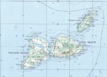
279:(Filipino: Pulo ng Poro) is an island in the province of
735:
303:, are located on Poro Island. It is one of the four
265:
255:
247:
239:
234:
224:
208:
198:
190:
182:
174:
166:
156:
119:
109:
104:
755:
8:
27:
620:. Unsourced material may be challenged and
762:
748:
26:
684:Learn how and when to remove this message
485:, and tourist attractions on Poro Island
553:Japanese occupation of the Philippines
505:
7:
716:
714:
618:adding citations to reliable sources
170:96.6 km (37.3 sq mi)
79:
46:
25:
726:This article about a location in
696:The Poro islands are home to the
493:
718:
590:
522:
499:
454:
436:
418:
400:
382:
364:
350:
336:
329:
78:
71:
45:
38:
786:Central Visayas geography stubs
730:region of the Philippines is a
528:
511:
477:Location of municipalities of
351:
1:
734:. You can help Knowledge by
337:
706:Komisyon ng Wikang Filipino
59:Location in the Philippines
802:
713:
194:1,240 ft (378 m)
186:9.8 km (6.09 mi)
455:
437:
419:
401:
383:
365:
270:
213:
92:Poro Island (Philippines)
32:
178:13 km (8.1 mi)
251:350/km (910/sq mi)
95:Show map of Philippines
266:Additional information
191:Highest elevation
614:improve this section
474:class=notpageimage|
137: /
62:Show map of Visayas
29:
698:Porohanon language
488:Natural features:
283:, located east of
199:Highest point
141:10.667°N 124.450°E
743:
742:
694:
693:
686:
668:
274:
273:
16:(Redirected from
793:
764:
757:
750:
722:
715:
704:(Bisaya) by the
689:
682:
678:
675:
669:
667:
626:
594:
586:
506:Pangunuron Falls
466:
458:
457:
448:
440:
439:
430:
422:
421:
412:
404:
403:
394:
386:
385:
376:
368:
367:
354:
353:
340:
339:
333:
260:Porohanon people
152:
151:
149:
148:
147:
142:
138:
135:
134:
133:
130:
96:
82:
81:
75:
63:
49:
48:
42:
30:
21:
801:
800:
796:
795:
794:
792:
791:
790:
781:Islands of Cebu
771:
770:
769:
768:
728:Central Visayas
711:
690:
679:
673:
670:
627:
625:
611:
595:
584:
575:
567:
540:
535:
534:
533:
486:
476:
470:
469:
468:
467:
462:
459:
451:
450:
449:
444:
441:
433:
432:
431:
426:
423:
415:
414:
413:
408:
405:
397:
396:
395:
390:
387:
379:
378:
377:
372:
369:
361:
360:
359:
355:
347:
346:
345:
341:
325:
305:Camotes Islands
220:
146:10.667; 124.450
145:
143:
139:
136:
131:
128:
126:
124:
123:
100:
99:
98:
97:
94:
93:
90:
89:
88:
87:
83:
66:
65:
64:
61:
60:
57:
56:
55:
54:
50:
23:
22:
15:
12:
11:
5:
799:
797:
789:
788:
783:
773:
772:
767:
766:
759:
752:
744:
741:
740:
723:
692:
691:
598:
596:
589:
583:
580:
574:
571:
566:
563:
539:
536:
532:
531:
525:
515:
514:
508:
502:
496:
472:
471:
461:
460:
453:
452:
443:
442:
435:
434:
425:
424:
417:
416:
407:
406:
399:
398:
389:
388:
381:
380:
371:
370:
363:
362:
357:
356:
349:
348:
343:
342:
335:
334:
328:
327:
326:
324:
321:
309:Pacijan Island
293:municipalities
272:
271:
268:
267:
263:
262:
257:
253:
252:
249:
245:
244:
241:
237:
236:
232:
231:
226:
222:
221:
214:
211:
210:
209:Administration
206:
205:
200:
196:
195:
192:
188:
187:
184:
180:
179:
176:
172:
171:
168:
164:
163:
158:
154:
153:
121:
117:
116:
111:
107:
106:
102:
101:
91:
85:
84:
77:
76:
70:
69:
68:
67:
58:
52:
51:
44:
43:
37:
36:
35:
34:
33:
24:
14:
13:
10:
9:
6:
4:
3:
2:
798:
787:
784:
782:
779:
778:
776:
765:
760:
758:
753:
751:
746:
745:
739:
737:
733:
729:
724:
721:
717:
712:
709:
707:
703:
699:
688:
685:
677:
666:
663:
659:
656:
652:
649:
645:
642:
638:
635: –
634:
633:"Poro Island"
630:
629:Find sources:
623:
619:
615:
609:
608:
604:
599:This section
597:
593:
588:
587:
581:
579:
572:
570:
564:
562:
560:
558:
554:
550:
546:
537:
530:
526:
524:
520:
519:
518:
513:
509:
507:
503:
501:
497:
495:
491:
490:
489:
484:
480:
475:
465:
447:
429:
411:
393:
375:
332:
322:
320:
318:
317:Tulang Island
314:
313:Ponson Island
310:
306:
302:
298:
294:
290:
286:
282:
278:
269:
264:
261:
258:
256:Ethnic groups
254:
250:
246:
243:36,508 (2015)
242:
238:
233:
230:
227:
223:
219:
218:
212:
207:
204:
201:
197:
193:
189:
185:
181:
177:
173:
169:
165:
162:
159:
155:
150:
122:
118:
115:
112:
108:
103:
74:
41:
31:
19:
736:expanding it
725:
710:
697:
695:
680:
671:
661:
654:
647:
640:
628:
612:Please help
600:
576:
568:
561:
557:World War II
541:
538:Bukilat Cave
516:
494:Bukilat Cave
487:
463:
445:
427:
409:
391:
373:
289:Leyte Island
287:and west of
276:
275:
248:Pop. density
235:Demographics
215:
555:during the
523:Flying Fish
500:Busay Falls
307:along with
285:Cebu Island
277:Poro Island
217:Philippines
203:Three Peaks
161:Philippines
157:Archipelago
144: /
120:Coordinates
114:Camotes Sea
86:Poro Island
53:Poro Island
28:Poro Island
775:Categories
644:newspapers
565:Waterfalls
549:stalagmite
545:stalactite
529:Santa Rosa
240:Population
674:July 2022
601:does not
573:Buho Rock
517:Beaches:
512:Buho Rock
323:Geography
105:Geography
18:Porohanon
582:Language
225:Province
132:124°27′E
110:Location
702:Cebuano
658:scholar
622:removed
607:sources
129:10°40′N
660:
653:
646:
639:
631:
483:Tudela
358:Tudela
315:, and
301:Tudela
291:. Two
175:Length
665:JSTOR
651:books
559:era.
183:Width
732:stub
637:news
605:any
603:cite
547:and
481:and
479:Poro
344:Poro
299:and
297:Poro
281:Cebu
229:Cebu
167:Area
616:by
527:6)
521:5)
510:4)
504:3)
498:2)
492:1)
777::
311:,
295:,
763:e
756:t
749:v
738:.
687:)
681:(
676:)
672:(
662:·
655:·
648:·
641:·
624:.
610:.
464:6
446:5
428:4
410:3
392:2
374:1
20:)
Text is available under the Creative Commons Attribution-ShareAlike License. Additional terms may apply.