61:
91:
44:
389:
98:
68:
368:
for the canals to maintain the required depth of 4 feet (1.2 m). The lakes were used for this purpose until the canals were abandoned in 1913. The lakes were then used to meet the water needs of the local industries. Some portions of the remnant canals in the Akron area can still be boated.
342:. Once the canal was completed, the town flourished. Several important industries brought prosperity to the area including stoneware potteries, sewer pipe manufacturing, the
270:
lies at one of the highest points of the state and on a major watershed divide in Ohio. Some water from the lakes reaches Lake Erie and some flows to the Ohio River.
545:
137:
550:
515:
266:. This proved advantageous for the Indians and early settlers as navigation from Lake Erie to the Ohio was possible with only an eight-mile portage.
540:
284:
90:
60:
240:
377:
323:, serving as a rendezvous point of American troops. The old Indian portage path was part of the ancient boundary between the
376:
maintained the canal lands for recreational purposes until 1949 when the
Portage Lakes were transferred to the newly formed
28:
373:
267:
500:
461:
484:
354:
industry. At one time, the Blue
Diamond Match Company in Akron used three million board feet (7,000 m³) of
535:
185:
339:
278:
274:
123:
43:
355:
365:
178:
255:
196:
488:
259:
388:
247:
203:
192:
529:
324:
17:
331:
320:
232:
501:
U.S. Geological Survey
Geographic Names Information System: Portage Lakes, Ohio
263:
299:
286:
152:
139:
251:
174:
462:
U.S. Geological Survey
Geographic Names Information System: Portage Lakes
520:
335:
316:
243:
186:
358:
351:
387:
343:
481:
347:
236:
169:
27:
For the singular, a number of different lakes or places, see
491:, Ohio State Parks, Ohio Department of Natural Resources
319:
and
Indians. It was a recognized landmark during the
217:
213:
202:
184:
168:
129:
119:
36:
364:Several of the Portage Lakes were built as feeder
312:Elevation: 1,053 feet (321 m), in the area.
130:
334:was laid out in 1825 and was first settled by
315:The area became an important trading post for
361:per year for the manufacture of its matches.
8:
273:There is an unincorporated community named
33:
457:
455:
392:Nimisila Reservoir in Summit County, Ohio
48:North Reservoir from Portage Lakes Drive
451:
546:Bodies of water of Summit County, Ohio
477:
475:
473:
471:
469:
516:Ohio DNR fishing map of Portage Lakes
97:
67:
7:
380:, Division of Parks and Recreation.
378:Ohio Department of Natural Resources
338:laborers and others working on the
25:
551:Kettle lakes in the United States
346:industry and, most recently, the
521:Portage Lakes State Park website
96:
89:
66:
59:
42:
374:Ohio Department of Public Works
216:
1:
541:Portages in the United States
239:. The name comes from an old
118:
110:Show map of the United States
235:and reservoirs in Northeast
262:, which flows south to the
567:
221:1,056 ft (322 m)
26:
327:and the Western Indians.
53:
41:
482:Portage Lakes State Park
268:Portage Lakes State Park
231:are a group of glacial
393:
391:
300:41.00722°N 81.52694°W
258:, a tributary of the
153:41.00639°N 81.52389°W
18:Portage Lakes (Ohio)
340:Ohio and Erie Canal
305:41.00722; -81.52694
296: /
246:that connected the
158:41.00639; -81.52389
149: /
124:Summit County, Ohio
487:2012-02-17 at the
417:Nimisila Reservoir
394:
250:flowing north to
225:
224:
218:Surface elevation
16:(Redirected from
558:
503:
498:
492:
479:
464:
459:
311:
310:
308:
307:
306:
301:
297:
294:
293:
292:
289:
256:Tuscarawas River
197:Tuscarawas River
188:
187:Primary outflows
164:
163:
161:
160:
159:
154:
150:
147:
146:
145:
142:
132:
111:
100:
99:
93:
81:
80:Show map of Ohio
70:
69:
63:
46:
34:
21:
566:
565:
561:
560:
559:
557:
556:
555:
526:
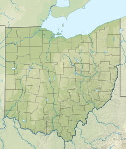
525:
512:
507:
506:
499:
495:
489:Wayback Machine
480:
467:
460:
453:
448:
429:North Reservoir
408:Turkeyfoot Lake
399:
386:
304:
302:
298:
295:
290:
287:
285:
283:
282:
260:Muskingum River
206: countries
157:
155:
151:
148:
143:
140:
138:
136:
135:
115:
114:
113:
112:
109:
108:
107:
106:
105:
101:
84:
83:
82:
79:
78:
77:
76:
75:
71:
49:
32:
23:
22:
15:
12:
11:
5:
564:
562:
554:
553:
548:
543:
538:
528:
527:
524:
523:
518:
511:
510:External links
508:
505:
504:
493:
465:
450:
449:
447:
444:
443:
442:
439:
436:
433:
430:
427:
424:
421:
418:
415:
412:
409:
406:
405:West Reservoir
403:
402:East Reservoir
398:
395:
385:
382:
248:Cuyahoga River
223:
222:
219:
215:
214:
211:
210:
207:
200:
199:
193:Cuyahoga River
190:
182:
181:
172:
166:
165:
133:
127:
126:
121:
117:
116:
103:
102:
95:
94:
88:
87:
86:
85:
73:
72:
65:
64:
58:
57:
56:
55:
54:
51:
50:
47:
39:
38:
24:
14:
13:
10:
9:
6:
4:
3:
2:
563:
552:
549:
547:
544:
542:
539:
537:
536:Lakes of Ohio
534:
533:
531:
522:
519:
517:
514:
513:
509:
502:
497:
494:
490:
486:
483:
478:
476:
474:
472:
470:
466:
463:
458:
456:
452:
445:
440:
437:
434:
431:
428:
425:
422:
419:
416:
413:
410:
407:
404:
401:
400:
396:
390:
383:
381:
379:
375:
370:
367:
362:
360:
357:
353:
349:
345:
341:
337:
333:
328:
326:
322:
318:
313:
309:
280:
279:Summit County
276:
275:Portage Lakes
271:
269:
265:
261:
257:
253:
249:
245:
242:
238:
234:
230:
229:Portage Lakes
220:
212:
209:United States
208:
205:
201:
198:
194:
191:
189:
183:
180:
176:
173:
171:
167:
162:
134:
128:
125:
122:
104:Portage Lakes
92:
74:Portage Lakes
62:
52:
45:
40:
37:Portage Lakes
35:
30:
19:
496:
438:Nesmith Lake
371:
363:
330:The city of
329:
314:
272:
244:portage path
233:kettle lakes
228:
226:
29:Portage Lake
441:Summit Lake
423:Dollar Lake
420:Miller Lake
325:Six Nations
321:War of 1812
303: /
291:081°31′37″W
156: /
131:Coordinates
530:Categories
446:References
435:Hower Lake
432:Grape Lake
366:reservoirs
356:white pine
288:41°00′26″N
264:Ohio River
175:artificial
144:81°31′26″W
426:Long Lake
384:Watershed
252:Lake Erie
170:Lake type
141:41°0′23″N
485:Archived
414:Mud Lake
411:Rex Lake
317:settlers
254:and the
120:Location
281:, near
179:natural
359:lumber
352:rubber
241:Indian
397:Lakes
344:match
336:Irish
332:Akron
204:Basin
372:The
350:and
348:tire
237:Ohio
227:The
195:and
177:and
277:in
532::
468:^
454:^
31:.
20:)
Text is available under the Creative Commons Attribution-ShareAlike License. Additional terms may apply.