67:
79:
736:
52:
171:
297:, the township has a total area of 14.5 square miles (37.5 km), of which 14.4 square miles (37.2 km) is land and 0.1 square miles (0.3 km), or 0.69%, is water. Sinnemahoning Portage Creek, flowing north to south, runs through the northern portion of the township. The creek is part of the
458:
In the township the population was spread out, with 29.1% under the age of 18, 6.6% from 18 to 24, 29.8% from 25 to 44, 19.4% from 45 to 64, and 15.1% who were 65 years of age or older. The median age was 34 years. For every 100 females there were 95.5 males. For every 100 females age 18 and over,
454:
living together, 9.4% had a female householder with no husband present, and 26.0% were non-families. 24.0% of all households were made up of individuals, and 10.4% had someone living alone who was 65 years of age or older. The average household size was 2.69 and the average family size was 3.18.
66:
863:
462:
The median income for a household in the township was $ 34,125, and the median income for a family was $ 39,750. Males had a median income of $ 32,361 versus $ 26,161 for females. The
669:
912:
423:
was 14.2 people per square mile (5.5/km). There were 136 housing units at an average density of 7.5/sq mi (2.9/km). The racial makeup of the township was 98.84%
78:
20:
774:
279:
902:
754:
907:
759:
792:
566:
662:
240:
817:
655:
51:
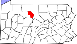
286:, the Cameron County seat, is 2 miles (3 km) to the west. The hamlet of Sizerville is in the northern part of the township, next to
487:
111:
647:
517:
428:
270:
Portage
Township is located in northeastern Cameron County and has a narrow, north–south-oriented shape. It is bordered by
764:
432:
302:
275:
679:
255:
116:
840:
797:
618:
306:
294:
271:
570:
381:
366:
351:
259:
228:
89:
567:"Geographic Identifiers: 2010 Demographic Profile Data (G001): Portage township, Cameron County, Pennsylvania"
784:
746:
720:
450:
There were 96 households, out of which 36.5% had children under the age of 18 living with them, 59.4% were
725:
712:
701:
440:
283:
822:
642:
287:
57:
847:
827:
466:
for the township was $ 15,001. None of the families and 3.2% of the population were living below the
444:
309:, rise a short distance south of Allegheny Portage Creek, a north-flowing stream that is part of the
213:
807:
436:
424:
298:
420:
592:
537:
463:
203:
419:
of 2000, there were 258 people, 96 households, and 71 families residing in the township. The
549:
310:
42:
896:
233:
467:
104:
694:
314:
99:
878:
865:
194:
451:
416:
220:
199:
71:
Map of
Cameron County, Pennsylvania highlighting Portage Township
651:
734:
470:, including no under eighteens and 10.3% of those over 64.
614:
569:. U.S. Census Bureau, American Factfinder. Archived from
19:
511:
509:
507:
505:
806:
783:
745:
711:
239:
227:
210:
193:
185:
177:
164:
159:
151:
143:
135:
130:
122:
110:
98:
88:
33:
305:. The headwaters of the creek, to the north in
258:, United States. The population was 163 at the
21:Portage Township, Pennsylvania (disambiguation)
35:Portage Township, Cameron County, Pennsylvania
663:
561:
559:
8:
518:"City and Town Population Totals: 2020-2021"
670:
656:
648:
447:of any race were 0.39% of the population.
324:
30:
913:Townships in Cameron County, Pennsylvania
643:Sizerville and Portage Township history
479:
238:
226:
192:
158:
129:
121:
87:
63:
48:
28:Township in Pennsylvania, United States
16:Township in Pennsylvania, United States
545:
535:
344:
209:
184:
176:
163:
150:
147:14.37 sq mi (37.21 km)
142:
139:14.47 sq mi (37.47 km)
134:
109:
97:
75:
7:
903:Populated places established in 1820
908:1820 establishments in Pennsylvania
155:0.10 sq mi (0.26 km)
83:Map of Cameron County, Pennsylvania
678:Municipalities and communities of
593:"Census of Population and Housing"
334:
14:
301:watershed, which connects to the
170:
169:
77:
65:
50:
1:
490:. United States Census Bureau
303:West Branch Susquehanna River
681:Cameron County, Pennsylvania
282:to the west. The borough of
256:Cameron County, Pennsylvania
619:United States Census Bureau
488:"2016 U.S. Gazetteer Files"
295:United States Census Bureau
178: • Estimate
929:
278:to the south and east and
189:11.14/sq mi (4.30/km)
18:
836:
732:
692:
408:
395:
380:
365:
350:
343:
338:
333:
330:
262:, down from 171 in 2010.
76:
64:
56:Road through conifers in
49:
40:
459:there were 94.7 males.
739:
313:system flowing to the
879:41.48333°N 78.19972°W
738:
615:"U.S. Census website"
409:U.S. Decennial Census
326:Historical population
288:Sizerville State Park
212: • Summer (
58:Sizerville State Park
849:United States portal
573:on February 13, 2020
186: • Density
884:41.48333; -78.19972
875: /
842:Pennsylvania portal
516:Bureau, US Census.
327:
299:Sinnemahoning Creek
740:
548:has generic name (
524:. US Census Bureau
421:population density
325:
274:to the northeast,
165: • Total
152: • Water
136: • Total
858:
857:
464:per capita income
413:
412:
293:According to the
254:is a township in
249:
248:
144: • Land
920:
890:
889:
887:
886:
885:
880:
876:
873:
872:
871:
868:
850:
843:
737:
704:
697:
687:
682:
672:
665:
658:
649:
630:
629:
627:
625:
611:
605:
604:
602:
600:
589:
583:
582:
580:
578:
563:
554:
553:
547:
543:
541:
533:
531:
529:
513:
500:
499:
497:
495:
484:
429:African American
346:
341:
336:
328:
280:Shippen Township
252:Portage Township
217:
173:
172:
81:
69:
54:
31:
928:
927:
923:
922:
921:
919:
918:
917:
893:
892:
883:
881:
877:
874:
869:
866:
864:
862:
861:
859:
854:
848:
841:
832:
809:
802:
779:
741:
735:
730:
707:
702:
695:
688:
685:
680:
676:
639:
634:
633:
623:
621:
613:
612:
608:
598:
596:
591:
590:
586:
576:
574:
565:
564:
557:
544:
534:
527:
525:
515:
514:
503:
493:
491:
486:
485:
481:
476:
452:married couples
433:Native American
339:
323:
311:Allegheny River
276:Lumber Township
268:
211:
84:
72:
60:
45:
36:
29:
24:
17:
12:
11:
5:
926:
924:
916:
915:
910:
905:
895:
894:
856:
855:
853:
852:
845:
837:
834:
833:
831:
830:
825:
820:
814:
812:
808:Unincorporated
804:
803:
801:
800:
795:
789:
787:
781:
780:
778:
777:
772:
767:
762:
757:
751:
749:
743:
742:
733:
731:
729:
728:
723:
717:
715:
709:
708:
693:
690:
689:
677:
675:
674:
667:
660:
652:
646:
645:
638:
637:External links
635:
632:
631:
606:
584:
555:
501:
478:
477:
475:
472:
411:
410:
406:
405:
402:
400:
397:
393:
392:
389:
387:
384:
378:
377:
374:
372:
369:
363:
362:
359:
357:
354:
348:
347:
342:
337:
332:
322:
319:
267:
264:
247:
246:
243:
237:
236:
231:
225:
224:
218:
208:
207:
197:
191:
190:
187:
183:
182:
179:
175:
174:
166:
162:
161:
157:
156:
153:
149:
148:
145:
141:
140:
137:
133:
132:
128:
127:
124:
120:
119:
114:
108:
107:
102:
96:
95:
92:
86:
85:
82:
74:
73:
70:
62:
61:
55:
47:
46:
41:
38:
37:
34:
27:
15:
13:
10:
9:
6:
4:
3:
2:
925:
914:
911:
909:
906:
904:
901:
900:
898:
891:
888:
851:
846:
844:
839:
838:
835:
829:
826:
824:
821:
819:
816:
815:
813:
811:
805:
799:
798:Sinnamahoning
796:
794:
793:Prospect Park
791:
790:
788:
786:
782:
776:
773:
771:
768:
766:
763:
761:
758:
756:
753:
752:
750:
748:
744:
727:
724:
722:
719:
718:
716:
714:
710:
706:
705:
698:
691:
686:United States
683:
673:
668:
666:
661:
659:
654:
653:
650:
644:
641:
640:
636:
620:
616:
610:
607:
594:
588:
585:
572:
568:
562:
560:
556:
551:
539:
523:
519:
512:
510:
508:
506:
502:
489:
483:
480:
473:
471:
469:
465:
460:
456:
453:
448:
446:
442:
438:
434:
430:
426:
422:
418:
407:
403:
401:
398:
394:
390:
388:
385:
383:
379:
375:
373:
370:
368:
364:
360:
358:
355:
353:
349:
329:
320:
318:
316:
312:
308:
307:Potter County
304:
300:
296:
291:
289:
285:
281:
277:
273:
272:Potter County
265:
263:
261:
257:
253:
244:
242:
235:
232:
230:
222:
219:
215:
205:
204:Eastern (EST)
201:
198:
196:
188:
180:
167:
154:
146:
138:
125:
118:
115:
113:
106:
103:
101:
94:United States
93:
91:
80:
68:
59:
53:
44:
39:
32:
26:
22:
860:
769:
700:
622:. Retrieved
609:
597:. Retrieved
595:. Census.gov
587:
575:. Retrieved
571:the original
546:|last1=
526:. Retrieved
521:
492:. Retrieved
482:
468:poverty line
461:
457:
449:
414:
321:Demographics
292:
269:
251:
250:
245:42-023-62064
105:Pennsylvania
25:
882: /
810:communities
696:County seat
624:January 31,
396:2021 (est.)
315:Ohio Valley
260:2020 census
897:Categories
870:78°11′59″W
867:41°29′00″N
522:Census.gov
494:August 13,
474:References
435:and 0.39%
415:As of the
160:Population
747:Townships
721:Driftwood
266:Geography
241:FIPS code
229:Area code
195:Time zone
726:Emporium
713:Boroughs
703:Emporium
577:April 1,
538:cite web
528:July 17,
441:Hispanic
431:, 0.39%
427:, 0.39%
284:Emporium
43:Township
823:Mix Run
818:Jericho
775:Shippen
770:Portage
599:June 4,
123:Settled
117:Cameron
90:Country
828:Truman
765:Lumber
755:Gibson
445:Latino
417:census
376:−33.7%
331:Census
112:County
760:Grove
437:Asian
425:White
404:−1.8%
391:−4.7%
223:(EDT)
221:UTC-4
200:UTC-5
100:State
785:CDPs
626:2008
601:2016
579:2015
550:help
530:2022
496:2017
382:2020
367:2010
352:2000
340:Note
335:Pop.
168:163
131:Area
126:1820
443:or
399:160
386:163
371:171
356:258
234:814
214:DST
181:160
899::
699::
684:,
617:.
558:^
542::
540:}}
536:{{
520:.
504:^
439:.
345:%±
317:.
290:.
671:e
664:t
657:v
628:.
603:.
581:.
552:)
532:.
498:.
361:—
216:)
206:)
202:(
23:.
Text is available under the Creative Commons Attribution-ShareAlike License. Additional terms may apply.