31:
30:
43:
53:
109:
21:
78:
98:
74:
62:
66:
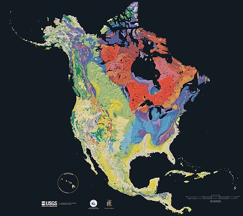
101:. From most recent to oldest, age is indicated by color: yellow, green, blue, red.
17:
97:
events are exposed in the three dimensions of space and the fourth dimension,
82:
90:
94:
70:
58:
86:
103:
37:
29:
69:
and a shaded relief image. This combination reveals the
8:
89:. Regional surface processes as well as
7:
28:
44:United States Geological Survey
1:
77:through the interrelation of
54:Cartographic relief depiction
57:showing the varying age of
130:
40:
65:. This image combines a
34:Geology of North America
110:More selected pictures
35:
33:
36:
117:
116:
50:
49:
46:
121:
104:
41:
38:
22:Selected picture
129:
128:
124:
123:
122:
120:
119:
118:
113:
102:
26:
25:
24:
12:
11:
5:
127:
125:
115:
114:
107:
51:
48:
47:
27:
15:
14:
13:
10:
9:
6:
4:
3:
2:
126:
112:
111:
106:
105:
100:
99:geologic time
96:
92:
88:
84:
80:
76:
75:North America
72:
68:
64:
63:North America
60:
56:
55:
45:
39:
32:
23:
19:
108:
67:geologic map
52:
73:history of
61:underlying
18:Portal:Maps
83:topography
91:continent
79:rock type
95:tectonic
71:geologic
42:Credit:
20: |
93:-scale
59:bedrock
16:<
87:time
85:and
81:,
Text is available under the Creative Commons Attribution-ShareAlike License. Additional terms may apply.