40:
53:
621:
60:
496:
3.3 kilometres (2.1 mi) to the south by crossing the Lac-Sept-Îles road, in a valley initially encased between the mountains (whose summit reaches 380 metres (1,250 ft) at the east and another 330 metres (1,080 ft) to the west, crossing four small lakes, to the outlet (coming from the
568:
12.0 kilometres (7.5 mi) towards the southwest by forming a hook towards the west, then a second towards the east, passing under the Bishop bridge, collecting the stream from rang Saint-Charles (coming from the west) and the brook at Jess's (coming from the west), then passing through
447:
The surface of the
Portneuf River (except the rapids areas) is generally frozen from the beginning of December to the end of March; safe circulation on the ice is generally done from the end of December to the beginning of March. The water level of the river varies with the seasons and the
507:
5.1 kilometres (3.2 mi) a priori towards the south in an agricultural zone, then towards the south-east bypassing a mountain whose summit reaches 265 metres (869 ft) and passing through Bourg-Louis (hamlet) where the course makes streamers, up to a bend in the
511:
7.7 kilometres (4.8 mi) to the southwest by crossing Bourg-Louis Falls, then by tracing streamers in the forest area; then branching south-east where the course crosses Chemin de la
Traverse, to the outlet (coming from the north) of Lac
530:
5.1 kilometres (3.2 mi) towards the south-east by collecting a stream (coming from the north-east), crossing a long series of rapids and forming a loop towards the south-east at the end of the segment, until boulevard Nord-Dame
678:
Source: "Names and places of Quebec", work of the
Commission of toponymy of Quebec, appeared in 1994 and 1996 in the form of a printed illustrated dictionary, and in that of a CD made by the company Micro-Intel, in 1997, from this
560:
1.9 kilometres (1.2 mi) to the southwest by forming a first loop to the north, bypassing the village of Saint-Basile-Sud to the east and south and crossing the boulevard du
Centenaire, until 'at the confluence of the
577:
Some infrastructures have been erected in this hydrographic slope notably mills (saw and flour) and shipyards (in the lower zone). Two disused dams are listed in the municipalities of
Portneuf and Notre-Dame-de-Portneuf.
581:
A quay of one km in length, was built on the Saint-Laurent river during the years 1956 to 1958 by the city of
Portneuf west of the mouth of the Portneuf river. This Portneuf wharf points southeast toward Pointe-Platon
486:
From the mouth of Lac Sept Îles, the current of the
Portneuf River descends on 55 kilometres (34 mi), with a drop of 204 metres (669 ft), according to the following segments:
754:
52:
282:
205:
538:
11.3 kilometres (7.0 mi) towards the south-west by winding intermittently by collecting the
Morasse stream (coming from the north), until the outlet of the
483:(length: 4.2 kilometres (2.6 mi); altitude: 209 metres (686 ft)) which discharge from the southwest. The resort area is very dense around this lake.
583:
668:
Atlas of Canada - Department of
Natural Resources Canada - Portneuf River - Length of segments established using the distance measurement application.
39:
444:, in the village of Saint-Basile and the village of Portneuf, agriculture and forestry constitute the main economic activities of the sector.
749:
411:
182:
133:
539:
351:
606:
702:
419:
480:
166:
21:
524:
355:
729:
562:
373:
724:
469:
500:
4.0 kilometres (2.5 mi) south-east passing north-east of Paquet
Airport, crossing the Chemin de la Grande Ligne (
554:
377:
719:
653:
380:, Morasse stream, Lac BP outlet, unidentified stream, unidentified stream, discharge from two unidentified lakes.
17:
634:
399:
359:
473:
178:
598:
The name of this river is linked to the seigniory of Portneuf which it crosses before flowing into the
688:
599:
403:
256:
147:
714:
457:
391:
605:
The toponym "Rivière Portneuf" was formalized on December 5, 1968, at the Place Names Bank of the
602:. Although this seigniory was allotted in 1636, the act of the concession was confirmed in 1647.
587:
415:
186:
143:
119:
461:
570:
532:
501:
434:
430:
407:
268:
84:
523:
3.7 kilometres (2.3 mi) towards the south-east, winding up to the confluence of the
743:
626:
465:
441:
437:), chemin de Bourg-Louis, chemin de la Grande Ligne and chemin du Lac Sept-Îles-Sud.
395:
372:(Upward from the mouth) Ruisseau chez Jess, rang Saint-Charles stream, Gagné stream,
689:
Commission de toponymie du Québec - Bank of Place Names - Toponym: Rivière Portneuf
362:, unidentified stream, unidentified stream, discharge from two unidentified lakes.
251:
616:
667:
553:
0.9 kilometres (0.56 mi) forming a large S, up to the confluence of the
297:
284:
220:
207:
123:
504:), to the outlet (from the northeast) of two small unidentified lakes;
433:, chemin Neuf, chemin du rang Saint-Angélique, chemin du Grand Rang (
423:
190:
109:
573:, cutting highway 40, route 138 and the path of iron to its mouth.
59:
590:. This quay is a gathering place for local festivities.
456:
The Portneuf River is located on the north shore of the
497:
west) of two lakes, one of which includes Cantin beach;
468:, more precisely between the hydrographic slopes the
440:
Except for the segments passing through a hamlet of
366:
344:
336:
331:
323:
313:
274:
262:
250:
236:
197:
172:
162:
153:
139:
129:
115:
105:
97:
92:
72:
32:
429:The Portneuf river valley is mainly served by
8:
654:Open Street Map - Accessed February 12, 2020
519:(segment of 20.1 kilometres (12.5 mi))
492:(segment of 20.1 kilometres (12.5 mi))
76:
549:(segment of 14.8 kilometres (9.2 mi))
350:(Upward from the mouth) Le grand Ruisseau,
517:Intermediate course of the Portneuf river
479:The Portneuf River draws its source from
390:is a tributary of the north shore of the
755:Tributaries of the Saint Lawrence River
663:
661:
646:
584:Lotbinière Regional County Municipality
414:, in the administrative region of the
29:
586:), located on the south shore of the
412:Portneuf Regional County Municipality
183:Portneuf Regional County Municipality
134:Portneuf Regional County Municipality
7:
547:Lower course of the Portneuf river
490:Upper course of the Portneuf river
14:
607:Commission de toponymie du Québec
394:, crossing the municipalities of
619:
58:
51:
38:
354:, Savane stream, Froid stream,
276: • coordinates
199: • coordinates
167:Sept Îles Lake (Saint-Raymond)
1:
565:(coming from the north-west);
563:Chaude River (Portneuf River)
154:Physical characteristics
750:Rivers of Capitale-Nationale
557:(coming from the northwest);
542:(coming from the northeast);
315: • elevation
238: • elevation
130:Regional County Municipality
730:GPX (secondary coordinates)
264: • location
174: • location
771:
15:
725:GPX (primary coordinates)
700:Map all coordinates using
246:
158:
46:
37:
708:Download coordinates as:
635:List of rivers of Quebec
527:(coming from the north);
368: • right
242:209 m (686 ft)
346: • left
327:55 km (34 mi)
27:River in Quebec, Canada
472:(to the west) and the
77:
720:GPX (all coordinates)
569:Portneuf-Station and
555:Rivière des Sept Îles
474:Jacques-Cartier River
378:Rivière des Sept Îles
319:5 m (16 ft)
298:46.93389°N 71.80666°W
221:46.93389°N 71.74667°W
600:Saint Lawrence river
257:Saint Lawrence river
16:For other uses, see
540:Saint-Jacques River
458:Saint-Laurent river
392:Saint-Laurent river
352:Saint-Jacques River
332:Basin features
303:46.93389; -71.80666
294: /
226:46.93389; -71.74667
217: /
588:St. Lawrence River
460:, halfway between
416:Capitale-Nationale
187:Capitale-Nationale
120:Capitale-Nationale
470:Sainte-Anne River
384:
383:
762:
691:
686:
680:
676:
670:
665:
656:
651:
629:
624:
623:
622:
388:Rivière Portneuf
369:
358:, the outlet of
347:
309:
308:
306:
305:
304:
299:
295:
292:
291:
290:
287:
239:
232:
231:
229:
228:
227:
222:
218:
215:
214:
213:
210:
200:
175:
88:
80:
78:Rivière Portneuf
62:
61:
55:
42:
30:
770:
769:
765:
764:
763:
761:
760:
759:
740:
739:
738:
737:
736:
735:
734:
695:
694:
687:
683:
677:
673:
666:
659:
652:
648:
643:
625:
620:
618:
615:
596:
476:(to the east).
454:
448:precipitation.
367:
345:
316:
302:
300:
296:
293:
288:
285:
283:
281:
280:
277:
265:
237:
225:
223:
219:
216:
211:
208:
206:
204:
203:
198:
173:
82:
68:
67:
66:
65:
64:
63:
28:
25:
12:
11:
5:
768:
766:
758:
757:
752:
742:
741:
733:
732:
727:
722:
717:
711:
705:
698:
697:
696:
693:
692:
681:
671:
657:
645:
644:
642:
639:
638:
637:
631:
630:
614:
611:
595:
592:
575:
574:
566:
558:
544:
543:
536:
528:
514:
513:
509:
505:
498:
481:Sept Îles Lake
462:Trois-Rivières
453:
450:
382:
381:
370:
364:
363:
348:
342:
341:
338:
334:
333:
329:
328:
325:
321:
320:
317:
314:
311:
310:
278:
275:
272:
271:
266:
263:
260:
259:
254:
248:
247:
244:
243:
240:
234:
233:
201:
195:
194:
176:
170:
169:
164:
160:
159:
156:
155:
151:
150:
141:
140:Municipalities
137:
136:
131:
127:
126:
117:
113:
112:
107:
103:
102:
99:
95:
94:
90:
89:
74:
70:
69:
57:
56:
50:
49:
48:
47:
44:
43:
35:
34:
33:Portneuf River
26:
22:Portneuf River
13:
10:
9:
6:
4:
3:
2:
767:
756:
753:
751:
748:
747:
745:
731:
728:
726:
723:
721:
718:
716:
713:
712:
710:
709:
704:
703:OpenStreetMap
701:
690:
685:
682:
675:
672:
669:
664:
662:
658:
655:
650:
647:
640:
636:
633:
632:
628:
627:Rivers portal
617:
612:
610:
608:
603:
601:
593:
591:
589:
585:
579:
572:
567:
564:
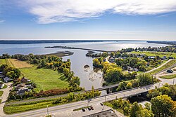
559:
556:
552:
551:
550:
548:
541:
537:
534:
529:
526:
525:Blanche River
522:
521:
520:
518:
510:
506:
503:
499:
495:
494:
493:
491:
487:
484:
482:
477:
475:
471:
467:
463:
459:
451:
449:
445:
443:
442:Saint-Raymond
438:
436:
432:
427:
426:, in Canada.
425:
421:
417:
413:
409:
405:
401:
397:
396:Saint-Raymond
393:
389:
379:
375:
371:
365:
361:
357:
356:Blanche River
353:
349:
343:
339:
335:
330:
326:
322:
318:
312:
307:
279:
273:
270:
267:
261:
258:
255:
253:
249:
245:
241:
235:
230:
202:
196:
192:
188:
184:
180:
179:Saint-Raymond
177:
171:
168:
165:
161:
157:
152:
149:
145:
142:
138:
135:
132:
128:
125:
121:
118:
114:
111:
108:
104:
100:
96:
91:
86:
79:
75:
71:
54:
45:
41:
36:
31:
23:
19:
707:
706:
699:
684:
674:
649:
604:
597:
580:
576:
546:
545:
516:
515:
489:
488:
485:
478:
455:
446:
439:
428:
387:
385:
374:Chaude River
360:Sergent Lake
148:Saint-Basile
679:dictionary.
404:Sant-Basile
337:Tributaries
301: /
224: /
73:Native name
744:Categories
641:References
400:Pont-Rouge
289:71°48′24″W
286:46°56′02″N
212:71°44′48″W
209:46°56′02″N
144:Pont-Rouge
533:route 365
502:route 367
452:Geography
435:route 365
431:route 138
418:, in the
410:, in the
613:See also
594:Toponymy
571:Portneuf
512:Sergent;
420:province
408:Portneuf
269:Portneuf
193:, Canada
124:Mauricie
106:Province
93:Location
18:Portneuf
98:Country
508:river;
466:Quebec
424:Quebec
340:
324:Length
191:Quebec
181:, MRC
163:Source
116:Region
110:Quebec
101:Canada
85:French
81:
252:Mouth
464:and
406:and
386:The
20:and
715:KML
422:of
746::
660:^
609:.
535:);
402:,
398:,
376:,
189:,
185:,
146:,
122:,
582:(
531:(
87:)
83:(
24:.
Text is available under the Creative Commons Attribution-ShareAlike License. Additional terms may apply.