59:
40:
378:
in the mid-18th century. Legend has it that his name appeared so frequently carved on trees in the valley of this river that later explorers and early pioneers came to call the stream "Powell's River" and the valley "Powell's Valley".
496:
Obtained from adding the length of the
Tennessee section of the river, indicated as 115.5 miles on USGS topographical maps, to the Virginia section of the river, indicated as 80 miles on the
487:
U.S. Geological Survey. Demory, TN. 1:24,000. Coordinates given for the mouth in GNIS (36.4996300, -83.672000) refer to a point 56 miles upstream from the river's mouth.
664:
674:
588:
194:
669:
419:
stocks trout in the shallow rushing waters of the Middle Fork under a "delayed harvest" designation. Downstream from Lee County, the river is home to
416:
684:
679:
125:
509:
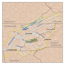
363:. It drains approximately 954 square miles (2,471 km) in both Virginia and Tennessee before reaching its confluence with the
347:
with
Roaring Fork in the Kent Junction community. From Kent Junction the river flows until it meets the North Fork of the river near
386:(EPA) as the “second most biologically diverse aquatic system in the nation.” The Powell is under pressure from the effects of
383:
654:
659:
409:
401:
180:
49:
585:
634:
405:
375:
476:
639:
356:
564:
Jefferson
National Forest (N.F.), Revised Land and Resource Management Plan: Environmental Impact Statement
336:
111:
497:
360:
45:
605:
562:
325:
543:
348:
273:
17:
512:, Tennessee Department of Environment and Conservation website, 2008. Retrieved: 8 June 2015.
510:
Powell River
Watershed (06010206) of the Tennessee River Basin: Water Quality Management Plan
412:. The center allows for on-site research of water quality, flora, fauna and related habitat.
352:
340:
374:
The Powell River was named for
Ambrose Powell who accompanied the exploration party of Dr.
592:
424:
420:
391:
329:
269:
39:
648:
77:
364:
176:
452:
171:
58:
368:
344:
209:
196:
140:
127:
428:
276:, 65.4 miles (105.3 km) above the mouth(mean for water years 1919-1979)
91:
415:
Fishing in the Powell River can be great in some areas; in Wise County the
404:
operates the Powell River
Aquatic Research Station, which is located where
440:
432:
87:
477:
U.S. Geological Survey
Geographic Names Information System: Powell River
444:
395:
286:
1,157 cu ft/s (32.8 m/s)(mean for water years 1919-1979)
448:
387:
436:
532:, Water Data Report TN-79-1, p. 199. Gaging station 03532000.
371:
reservoir at the site of the town of
Grantsboro, Tennessee.
324:
is a 195-mile-long river in the United States that rises in
567:. United States Forest Service. January 2004. pp. 4–32
455:. A lot of people kayak the river and even wade to fish.
498:
Virginia
Department of Game and Inland Fisheries website
302:
290:
280:
263:
255:
243:
235:
225:
186:
170:
156:
117:
106:
97:
83:
73:
68:
32:
586:LMU OPENS POWELL RIVER AQUATIC RESEARCH STATION
530:Water Resources Data Tennessee: Water Year 1979
339:, near the Laurel Grove community northwest of
524:
522:
520:
518:
8:
359:, and then runs nearly the entire length of
595:, Lincoln Memorial University press release
335:The South Fork of the river rises in rural
408:crosses the river at the Brooks Bridge in
57:
610:Virginia Department of Wildlife Resources
417:Virginia Department of Wildlife Resources
308:59,500 cu ft/s (1,680 m/s)
464:
382:The Powell River was designated by the
343:and flows for several miles before the
557:
555:
472:
470:
468:
29:
665:Rivers of Claiborne County, Tennessee
7:
675:Rivers of Campbell County, Tennessee
296:47 cu ft/s (1.3 m/s)
247:954 sq mi (2,470 km)
25:
670:Rivers of Union County, Tennessee
528:United States Geological Survey,
351:. The North Folk originates near
27:River in Tennessee, United States
38:
685:Rivers of Wise County, Virginia
384:Environmental Protection Agency
680:Rivers of Lee County, Virginia
398:and associated road-building.
188: • coordinates
119: • coordinates
18:Powell River (Tennessee River)
1:
239:195.5 mi (314.6 km)
98:Physical characteristics
227: • elevation
162:3,490 ft (1,060 m)
158: • elevation
410:Claiborne County, Tennessee
402:Lincoln Memorial University
265: • location
181:Claiborne County, Tennessee
50:Claiborne County, Tennessee
701:
304: • maximum
292: • minimum
282: • average
231:1,020 ft (310 m)
328:and flows southwest into
314:
251:
166:
102:
63:The Powell drainage basin
56:
37:
635:List of Tennessee rivers
606:"Delayed Harvest Waters"
406:Tennessee State Route 63
640:List of Virginia rivers
542:Collins, Lewis (1877).
357:Big Stone Gap, Virginia
355:. The river flows past
44:The Powell River near
337:Wise County, Virginia
210:36.29694°N 84.02611°W
141:37.03083°N 82.70694°W
112:Wise County, Virginia
361:Lee County, Virginia
655:Rivers of Tennessee
545:History of Kentucky
215:36.29694; -84.02611
206: /
146:37.03083; -82.70694
137: /
110:Indian Mountain in
660:Rivers of Virginia
591:2011-07-19 at the
326:Southwest Virginia
349:Woodway, Virginia
318:
317:
274:Arthur, Tennessee
16:(Redirected from
692:
622:
621:
619:
617:
602:
596:
583:
577:
576:
574:
572:
559:
550:
549:
539:
533:
526:
513:
507:
501:
494:
488:
485:
479:
474:
353:Keokee, Virginia
305:
293:
283:
266:
221:
220:
218:
217:
216:
211:
207:
204:
203:
202:
199:
159:
152:
151:
149:
148:
147:
142:
138:
135:
134:
133:
130:
120:
61:
42:
30:
21:
700:
699:
695:
694:
693:
691:
690:
689:
645:
644:
631:
626:
625:
615:
613:
604:
603:
599:
593:Wayback Machine
584:
580:
570:
568:
561:
560:
553:
541:
540:
536:
527:
516:
508:
504:
495:
491:
486:
482:
475:
466:
461:
425:largemouth bass
421:smallmouth bass
310:April 1977
309:
303:
297:
291:
281:
264:
228:
214:
212:
208:
205:
200:
197:
195:
193:
192:
189:
157:
145:
143:
139:
136:
131:
128:
126:
124:
123:
118:
64:
52:
28:
23:
22:
15:
12:
11:
5:
698:
696:
688:
687:
682:
677:
672:
667:
662:
657:
647:
646:
643:
642:
637:
630:
627:
624:
623:
597:
578:
551:
548:. p. 416.
534:
514:
502:
489:
480:
463:
462:
460:
457:
330:East Tennessee
316:
315:
312:
311:
306:
300:
299:
294:
288:
287:
284:
278:
277:
267:
261:
260:
257:
253:
252:
249:
248:
245:
241:
240:
237:
233:
232:
229:
226:
223:
222:
190:
187:
184:
183:
174:
168:
167:
164:
163:
160:
154:
153:
121:
115:
114:
108:
104:
103:
100:
99:
95:
94:
85:
81:
80:
75:
71:
70:
66:
65:
62:
54:
53:
43:
35:
34:
26:
24:
14:
13:
10:
9:
6:
4:
3:
2:
697:
686:
683:
681:
678:
676:
673:
671:
668:
666:
663:
661:
658:
656:
653:
652:
650:
641:
638:
636:
633:
632:
628:
611:
607:
601:
598:
594:
590:
587:
582:
579:
566:
565:
558:
556:
552:
547:
546:
538:
535:
531:
525:
523:
521:
519:
515:
511:
506:
503:
499:
493:
490:
484:
481:
478:
473:
471:
469:
465:
458:
456:
454:
450:
446:
442:
438:
434:
430:
426:
422:
418:
413:
411:
407:
403:
399:
397:
393:
389:
385:
380:
377:
376:Thomas Walker
372:
370:
366:
362:
358:
354:
350:
346:
342:
338:
333:
331:
327:
323:
313:
307:
301:
295:
289:
285:
279:
275:
271:
268:
262:
258:
254:
250:
246:
242:
238:
234:
230:
224:
219:
191:
185:
182:
178:
175:
173:
169:
165:
161:
155:
150:
122:
116:
113:
109:
105:
101:
96:
93:
89:
86:
82:
79:
78:United States
76:
72:
67:
60:
55:
51:
47:
41:
36:
31:
19:
614:. Retrieved
609:
600:
581:
569:. Retrieved
563:
544:
537:
529:
505:
492:
483:
429:red eye bass
414:
400:
392:strip mining
381:
373:
365:Clinch River
334:
322:Powell River
321:
319:
298:January 1940
272:bridge near
177:Clinch River
33:Powell River
616:28 November
571:28 November
390:(including
369:Norris Lake
213: /
144: /
649:Categories
459:References
441:red horses
345:confluence
244:Basin size
201:84°01′34″W
198:36°17′49″N
132:82°42′25″W
129:37°01′51″N
451:and even
256:Discharge
92:Tennessee
46:Harrogate
629:See also
589:Archived
433:bluegill
88:Virginia
69:Location
445:walleye
396:logging
367:in the
74:Country
612:. 2022
449:sauger
388:mining
341:Norton
270:US-25E
259:
236:Length
107:Source
453:musky
172:Mouth
84:State
618:2022
573:2022
437:carp
320:The
394:),
179:in
48:in
651::
608:.
554:^
517:^
467:^
447:,
443:,
439:,
435:,
431:,
427:,
423:,
332:.
90:,
620:.
575:.
500:.
20:)
Text is available under the Creative Commons Attribution-ShareAlike License. Additional terms may apply.