31:
250:
712:
respectively. The more fine-grained peridotites are also more fertile, and some approximate the model composition for primitive mantle. Clinopyroxenite is found as veins or dikes, particularly within the more fine-grained peridotite. Equilibration temperatures range from 908–1,105 °C (1,666–2,021 °F) The xenoliths have P-wave velocities of 7.75 to 7.89 km/s, consistent with P-wave velocies in the Rio Grande rift of 7.6 to 7.8 km/s
642:
234:
727:) compositions. These likely took less than three days to reach the surface from their place of origin, and show pristine composition and texture. Their characteristics show that they were little altered from their formation 1.6 to 1.8 billion years ago, other than some reheating during the opening of the Rio Grande rift. Middle crustal xenoliths are Oligocene (26–27 Ma) in age and suggest a large unexposed
311:
780:
759:
and velocities within this region increase to more than 6.35 km/s. This greater density creates a lateral density contrast and in turn generates a long-wavelength gravity high. The upper mantle densities at the PVF decrease from 3280 to 3250 kg/m from west to east, based on a decrease in velocities from approximately 7.96 to 7.70 km/s.
763:
depth of approximately 3 km. The
Mesilla basin is an asymmetric basin that adjoins the eastern edge of the PVF and extends on to the western flank of the Franklin mountain uplift. At a depth of about 1.5 km the velocities in the western area range from approximately 2.4 km/s to 4.0 km/s at a depth of about 1.5 km.
274:. Aden-Afton Field is approximately 230 square kilometers (89 sq mi) in extent. The easternmost Black Mountain-Sao Thomas alignment is a north-south belt of vents near the Rio Grande that includes Santo Tomas, San Miguel, Little Clack Mountain and Black Mountain. The field consists almost entirely of
754:
Seismic velocity data, including reflected and refracted arrivals, shows that the upper 5 km of the crust beneath the
Portillo volcanic field (PVF) is characterized by alternating regions of low and high velocities of 2.5-3.7 km/s and 3.5-4.3 km/s, respectively. The velocities increase
688:
Kilbourne Hole is notable for the abundance of xenoliths in the crater ejecta. These are fragments of country rock carried intact to the surface by the eruption. Xenoliths at
Kilbourne Hole include both upper mantle rocks and lower crustal rocks and are most abundant in the northern and eastern rim.
302:
and Hunt's Hole maars. The two maars erupted through portions of pre-existing Afton series basalt flows. The Afton flows may have erupted through a fissure upon which the
Gardner cones were emplaced. Aden is a well-preserved shield volcano that at one time had a lava lake, which later solidified and
762:
Coyote Hill and the West
Portillo mountains make up the western portion of the PVF, with regional velocities in this uplift ranging from 4.5 km/s to over 6.0 km/s at a depth of 2.5 km. To the east is the Malpais basin, where velocities range from 1.68 km/s to 4.86 km/s at a
758:
The low crust of the PVF has a uniform density of 2880 kg/m. The upper to middle crust (between 5 km and 20 km) of the PVF includes a block with a density of 2740 kg/m. The density at 11 to 15 kilometers (6.8 to 9.3 mi) is 2880 kg/m. This body is a mid-crustal "welt"
711:
The peridotites range in texture from fine-grained equigranular through porphyroclastic to protogranular. This is interpreted as stratification by depth, with the three textural groups found at 26–42 kilometers (16–26 mi), 42–48 kilometers (26–30 mi), and over 48 kilometers (30 mi),
653:
of the
Potrillo volcanic field consists of over 100 cinder cones, ranging in age from 1 million to 20,000 years old. Slope angles of young cinder cones subject to mechanical weathering in an arid environment show a relationship with age. The cones of the Potrillo volcanic field have been
445:
Rift extension took place in an intense 30–20 Ma phase, involving low-angle normal faults, and a less intense post-10 Ma phase, involving high-angle normal faults. Mack and Seager (1995) argued that the
Quaternary magmatism in the West Potrillo field reached the surface via a transfer zone linking
306:
The western West
Potrillo field includes the Western Potrillo Mountains, a cavalcade of hundreds of coalescing cones and flows formed upon older, thick platform that is possibly fissure-fed stacked flows. Also within the western area are the Riley, Malpais, and Potrillo maars. Potrillo maar is
1303:
Hamblock, J. M.; Andronicos, C. L.; Miller, K. C.; Barnes, C. G.; Ren, M-H.; Averill, M. G.; Anthony, E. Y. (10 September 2007). "A composite geologic and seismic profile beneath the southern Rio Grande rift, New Mexico, based on xenolith mineralogy, temperature, and pressure".
458:
are rare isotopes created when a high-energy cosmic ray interacts with the nucleus of an atom. These isotopes are produced within earth materials such as rocks or soil, in Earth's atmosphere, and in extraterrestrial items such as meteorites.
291:, the upper 3 centimetres (1.2 in) of flow surfaces is sufficient enough for collecting samples desired. It is essential to collect samples with primarily display flow features, such as spatter, flow lineation, and cooling rinds.
322:
The central and eastern parts of the
Potrillo volcanic field were erupted onto the La Mesa surface, which formed between 900 and 700 Ka. There is a diversity of rock types beneath the Potrillo volcanics, ranging in age from
1033:
Anthony, Elizabeth Y.; Hoffer, Jerry M.; Waggoner, W. Kent; Chen, Weiping (1 August 1992). "Compositional diversity in late
Cenozoic mafic lavas in the Rio Grande rift and Basin and Range province, southern New Mexico".
269:
volcanoes and associated flows that covers approximately 1,250 square kilometers (480 sq mi). The central Aden–Afton field has a number of young flows, three cinder cones and three maar volcanoes, including
770:
interface concentrated below the PVF. The mid-crustal shows reflectivity increases between 40 and 70 kilometers (25 and 43 mi) offset; mid-crustal reflectivity is present between 4 and 6 seconds, reduced time.
387:
The Potrillo volcanic field is part of the southern Rio Grande rift and illustrates the Cenozoic tectonic evolution of that structure. The tectonic history of the area is recorded in the East Potrillo Mountains, a
317:
maar, created about 24,000 years ago when magma rising from deep within the Earth encountered groundwater, blowing out an irregularly shaped hole more than a mile across, 1.7 miles long, and hundreds of feet deep.
307:
included with the western alignment due to its position west of the Robledo fault. The West Potrillo field is the oldest of the Potrillo volcanic fields, with lavas ranging in age from 262 to 916 thousand years.
463:
determines the age of lava flows by measuring the accumulation of cosmogenic He since a flow crystallized. It is a technique that is optimal when working with well preserved young surface lavas (<700 ka).
679:
The new morphologic dating methods suggest that cinder cone formation in the Potrillo volcanic field may have occurred at different intervals and that the field may be currently developing new cinder cones.
1261:
Bussod, Gilles Y.A.; Williams, David R. (October 1991). "Thermal and kinematic model of the southern Rio Grande rift: inferences from crustal and mantle xenoliths from Kilbourne Hole, New Mexico".
1799:
42:
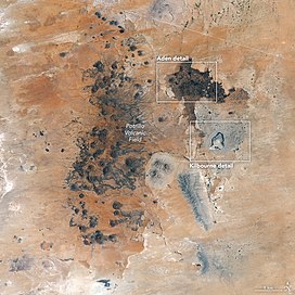
is at the top of this image, and NM-9 and the US-Mexican border are at the bottom (south). The prominent white line diagonally across the top appears to be a major electrical transmission line.
284:
Most of the eastern area vents are scoria cones, some of which have breach flows with pahoehoe surface. Lavas of Black Mountain have been dated as 69 to 85 thousand years old. When performing
1639:
Ulrich GE; Condit CD; Wenrich KJ; et al. (1989). Chapin, C.E.; Zidek, J (eds.). "Excursion 5A Miocene to Holocene volcanism and tectonism of the southern Colorado Plateau, Arizona".
415:= Early Cenozoic. Erosion has not exposed enough of the Laramide structures to determine whether this was thin-skinned overthrusting or deep faulting and uplift of basement blocks.
1769:
1693:
1579:
1122:"Qualitative age relationships of late Cenozoic cinder cones, southern Rio Grande rift, using cone morphology and LANDSAT thematic imagery: A preliminary assessment"
755:
with depth to approximately 6.0 km/s at 10 km, 6.5 km/s at 16 km, and they increase sharply from 6.9 to 8.0 km/s between 28 and 38 km.
852:
1774:
1804:
375:
occur. Rock samples collected in the northern part of the pyroclastic deposit of the Potrillo maar, and lava associated with a cinder cone yielded
1794:
80:
1546:
Lipman, PW Mehnert, HH (1975). "Late Cenozoic basaltic volcanism and development of the Rio Grande depression in the southern Rocky Mountains".
1759:
947:
1383:
1364:
1789:
295:
1481:
Averill M, 2007. A Lithospheric Investigation of the Southern Rio Grande Rift. Ph D Dissertation; University of Texas at El Paso. p 1-213
1754:
1078:"3He surface exposure dating and its implications for magma evolution in the Potrillo volcanic field, Rio Grande Rift, New Mexico, USA"
689:
Because these are samples of portions of the Earth that are inaccessible by mining or drilling, they are of great scientific interest.
1654:"Crust and upper mantle shear wave structure of the southwest United States; Implications for rifting and support for high elevation"
1716:
1563:
1014:
346:
654:
used to calibrate the age-slope angle relationship by comparison of He and Ar/Ar ages to slope angles obtained from overlapping
767:
1784:
1593:"Pyroxenite xenoliths from the Rio Puerco volcanic field, New Mexico: Melt metasomatism at the margin of the Rio Grande rift"
257:
The Potrillo volcanic field covers approximately 4,600 square kilometers (1,800 sq mi) of Doña Ana County. It is a
1171:"Magnetostratigraphy of the Plio-Pleistocene Camp Rice and Palomas formations in the Rio Grande rift of southern New Mexico"
746:
Xenoliths are almost entirely absent in the ejecta from Hunt's Hole, but xenoliths are found in Potrillo maar to the south.
1519:
1764:
73:
1779:
334:
sedimentary succession to basalt-andesite volcanics of the southern fringes of the Sierra de las Uvas volcanic field.
184:
1006:
258:
200:
1218:
Simons, Elwyn L.; Alexander, H. L. (January 1964). "Age of the Shasta Ground Sloth from Aden Crater, New Mexico".
1055:
1732:
1495:
1121:
1463:
Padovani, Elaine R.; Reid, Mary R. (1989). "Field guide to Kilbourne Hole maar, Dona Ana County, New Mexico".
261:
that can be divided in three volcanic regions. The westernmost West Potrillo Field consists of more than 100
1737:
1156:
288:
800:
655:
446:
two adjacent N–S-trending, long-lived, extensional structures—the West Robledo and Camel Mountain faults.
227:
155:
63:
1619:
353:) is one of the few specimens of this age which have been found with patches of skin and hair preserved.
1687:
1573:
431:
275:
230:, and occupies about 4,600 square kilometers (1,800 sq mi) near the U.S. border with Mexico.
30:
1665:
1406:
1313:
1270:
1185:
1089:
1043:
303:
partially collapsed to the west. Its lavas have been dated as between 15 and 19 thousand years old.
1442:, and Phillips, Fred M. (2001). \"Terrestrial in situ cosmogenic nuclides: Theory and application".
249:
145:
1422:
1243:
1235:
1708:
1702:
1340:
1712:
1559:
1010:
460:
361:
219:
129:
1170:
1673:
1604:
1588:
1551:
1414:
1321:
1278:
1227:
1193:
1097:
1051:
408:
704:. The olivine has a distinctive pale green color in which the pyroxene forms black flecks.
376:
438:
427:
423:
412:
393:
207:
177:
1669:
1410:
1317:
1274:
1189:
1093:
1047:
641:
418:
Middle to late Tertiary rotation of fault blocks due to either northeast or north-south
842:
826:
784:
314:
299:
278:
271:
237:
233:
203:
160:
1748:
1426:
1282:
1247:
1101:
650:
389:
215:
172:
124:
39:
1397:
Mack, G. H.; W. R. Seager (1995). "Transfer zones in the southern Rio Grande Rift".
430:
that resulted were closely spaced and consequently cut the Laramide structures. The
740:
338:
168:
1325:
924:
810:
736:
331:
324:
310:
262:
1727:
1342:
Geology of the East Potrillo Mountains and vicinity Dona Ana County, New Mexico
1723:
Contribution by: Crumpler LS, Aubele JC. Volcanic maar north of Red Hill Maar.
1439:
705:
693:
465:
396:
located in the southern part of the central area. This range exposes rocks of
372:
364:
341:
skeleton, which has been dated at about 11,000 years old. This is now at
211:
120:
1418:
1120:
Hoffer, Jerry M.; Penn, Brian S.; Quezada, Oscar A.; Morales, Monica (1998).
868:
854:
95:
82:
779:
728:
716:
472:
is also measured as a check that He has been retained by the samples taken.
368:
1652:
West, M Ni J, Baldridge SW, Wilson D, Aster R, Gao W, and Grand S (2004).
1345:. New Mexico: New Mexico Bureau of Mines and Mineral Resources. p. 5.
1678:
1653:
1197:
701:
659:
357:
1555:
1609:
1592:
697:
455:
401:
397:
327:
1239:
732:
720:
285:
223:
133:
53:
1077:
766:
There is increased seismic reflectivity within the crust and at the
38:
viewed from space, 2017. Outlined areas have blowups in text below.
1231:
739:
are notable scarce in the lower crustal xenoliths, suggesting that
1641:
Field Excursions to Volcanic Terranes in the Western United States
778:
724:
640:
248:
232:
1496:"Combined geophysical studies at Kilbourne Hole maar, New Mexico"
469:
419:
342:
266:
692:
Most of the mantle xenoliths at Kilbourne Hole are composed of
1354:
1352:
478:
Surface-exposure ages of samples from Potrillo volcanic field
1550:. Geological Society of America Memoirs. Mem.(144): 119–154.
360:
localities. These are Kilbourne Hole and Potrillo maar where
226:. The volcanic field lies 22 miles (35 km) southwest of
1056:
10.1130/0016-7606(1992)104<0973:CDILCM>2.3.CO;2
1527:
New Mexico Bureau of Mines and Mineral Resources Circular
1520:"Guidebook to Rio Grande rift in New Mexico and Colorado"
379:
ages of approximately 1.29 and 1.18 million years.
1465:
New Mexico Bureau of Mines and Mineral Resources Memoir
658:
digital elevation models and digital topographic maps
1458:
1456:
1454:
1452:
1704:
Volcanoes of North America: United States and Canada
441:
as a result of movement on high angle normal faults.
404:
age and shows three significant deformation events:
1169:Mack, G. H.; Salyards, S. L.; James, W. C. (1993).
1076:Anthony, Elizabeth Y; Poths, Jane (November 1992).
1028:
1026:
183:
166:
154:
144:
139:
116:
111:
72:
62:
52:
47:
23:
1115:
1113:
1111:
337:One of the lava tubes of Aden Crater contained a
1800:Organ Mountains–Desert Peaks National Monument
1157:"Preparing for the Moon and Mars at Potrillo "
743:has not taken place in this part of the rift.
356:The Potrillo volcanic field has two important
1382:sfn error: no target: CITEREFSeagerMack1994 (
1363:sfn error: no target: CITEREFSeagerMack1994 (
1159:, NASA Earth Observatory, September 19, 2017
8:
1692:: CS1 maint: multiple names: authors list (
1578:: CS1 maint: multiple names: authors list (
411:thrust faulting to the northeast during the
253:False-color image of Potrillo volcanic field
1377:
1358:
1298:
1296:
1294:
1292:
20:
18:Volcanic field in United States and Mexico
1677:
1608:
1129:New Mexico Geological Society Field Guide
434:continued throughout the Middle Cenozoic.
1770:Landforms of Doña Ana County, New Mexico
1001:Wood, Charles A.; Jűrgen Kienle (1993).
790:
715:Deep crustal rocks include a variety of
672:Group 2: age of around 125 Ka years old.
669:Group 1: age of around 250 Ka years old.
474:
309:
1503:New Mexico Geological Society Guidebook
996:
994:
992:
990:
988:
986:
984:
982:
958:
675:Group 3: age of around 60 Ka years old.
1707:. Cambridge University Press. p.
1685:
1571:
1152:
1150:
1071:
1069:
1067:
1065:
980:
978:
976:
974:
972:
970:
968:
966:
964:
962:
948:List of volcanoes in the United States
787:, last active about 16,000 years ago.
294:The central Aden-Afton field includes
708:is occasionally found here as well.
7:
1775:Landforms of Luna County, New Mexico
665:There are 3 groups of slope angles;
645:The volcanic field after a snowstorm
298:, Afton, the Gardner cones, and the
731:underlying the volcanic field. Meta
426:). The system of low angle normal
14:
1805:Cinder cones of the United States
1399:Journal of the Geological Society
1339:Seager, W. R.; Mack, G.H (1994).
347:Peabody Museum of Natural History
1505:. 26th Field Conference: 273–281
29:
1658:Journal of Geophysical Research
1082:Geochimica et Cosmochimica Acta
1795:Landforms of Chihuahua (state)
1:
1760:Volcanic fields of New Mexico
1548:Geological Society of America
847:1,292 m or 4,239 ft
1591:; Samuels, Kimberly (2006).
1283:10.1016/0040-1951(91)90051-S
1102:10.1016/0016-7037(92)90022-B
696:, a rock composed mostly of
461:Cosmogenic He surface dating
58:5,561 ft (1,695 m)
1790:Monogenetic volcanic fields
1326:10.1016/j.tecto.2007.04.006
1178:American Journal of Science
1821:
1755:Volcanic fields of Arizona
1444:Quaternary Science Reviews
1007:Cambridge University Press
1003:Volcanoes of North America
259:monogenetic volcanic field
1728:"Potrillo Volcanic Field"
1620:"Potrillo Volcanic Field"
580:Flow collected 5 km
450:Cosmogenic isotope dating
351:Nothrotheriops shastense
28:
1733:Global Volcanism Program
1419:10.1144/gsjgs.152.3.0551
624:Lava lake within crater
549:Flow resting on La Mesa
240:looking to the southwest
68:657 ft (200 m)
1738:Smithsonian Institution
1624:Volcanoes in the Desert
783:Aden Crater is a small
289:surface exposure dating
197:Potrillo volcanic field
36:Potrillo volcanic field
24:Potrillo volcanic field
1378:Seager & Mack 1994
1359:Seager & Mack 1994
891:80,000 years ago
821:16,000 years ago
788:
646:
637:Cinder cone morphology
540:Afton volcanic center
507:Upper flow associated
319:
254:
241:
189:> 150,000 years ago
150:< 2.65 million year
1785:Pleistocene volcanism
1701:Wood, Kienle (1990).
1518:Halley, J.W. (1978).
782:
719:of both high-silica (
644:
602:Spatter cone in Aden
571:Aden volcanic center
432:extensional tectonics
349:. This ground sloth (
313:
252:
236:
1679:10.1029/2003JB002575
1198:10.2475/ajs.293.1.49
1009:. pp. 310–313.
1765:Maars of New Mexico
1670:2004JGRB..109.3309W
1587:Porreca, Courtney;
1556:10.1130/mem144-p119
1494:Cordell, L (1975).
1411:1995JGSoc.152..551M
1318:2007Tectp.442...14H
1275:1991Tectp.197..373B
1190:1993AmJS..293...49M
1094:1992GeCoA..56.4105A
1048:1992GSAB..104..973A
864: /
92: /
1780:Pliocene volcanism
1618:Sharp, JW (2007).
1610:10.1130/ges00058.1
1220:American Antiquity
789:
723:) and low-silica (
647:
383:Structural geology
320:
255:
242:
96:31.900°N 107.200°W
48:Highest point
1589:Selverstone, Jane
1380:, pp. 23–24.
1361:, pp. 18–20.
1088:(11): 4105–4108.
939:
938:
896:Malpais tuff ring
634:
633:
591:From Aden crater
193:
192:
1812:
1741:
1722:
1697:
1691:
1683:
1681:
1648:
1635:
1633:
1631:
1614:
1612:
1583:
1577:
1569:
1542:
1540:
1538:
1524:
1514:
1512:
1510:
1500:
1482:
1479:
1473:
1472:
1460:
1447:
1437:
1431:
1430:
1394:
1388:
1387:
1375:
1369:
1368:
1356:
1347:
1346:
1336:
1330:
1329:
1300:
1287:
1286:
1269:(2–4): 373–389.
1258:
1252:
1251:
1215:
1209:
1208:
1206:
1204:
1175:
1166:
1160:
1154:
1145:
1144:
1142:
1140:
1126:
1117:
1106:
1105:
1073:
1060:
1059:
1030:
1021:
1020:
998:
888:
887:
885:
884:
883:
881:
876:
875:
870:
869:31.97°N 106.97°W
865:
862:
861:
860:
857:
791:
493:Age "Ka" (melt)
475:
107:
106:
104:
103:
102:
101:31.900; -107.200
97:
93:
90:
89:
88:
85:
33:
21:
1820:
1819:
1815:
1814:
1813:
1811:
1810:
1809:
1745:
1744:
1726:
1719:
1700:
1684:
1664:(109): B03309.
1651:
1638:
1629:
1627:
1617:
1586:
1570:
1566:
1545:
1536:
1534:
1522:
1517:
1508:
1506:
1498:
1493:
1490:
1488:Further reading
1485:
1480:
1476:
1462:
1461:
1450:
1438:
1434:
1396:
1395:
1391:
1381:
1376:
1372:
1362:
1357:
1350:
1338:
1337:
1333:
1302:
1301:
1290:
1260:
1259:
1255:
1217:
1216:
1212:
1202:
1200:
1173:
1168:
1167:
1163:
1155:
1148:
1138:
1136:
1124:
1119:
1118:
1109:
1075:
1074:
1063:
1032:
1031:
1024:
1017:
1000:
999:
960:
956:
944:
879:
877:
873:
871:
867:
866:
863:
858:
855:
853:
851:
850:
777:
752:
686:
639:
498:Black Mountain
452:
439:tectonic uplift
424:Rio Grande Rift
413:Late Cretaceous
385:
377:potassium–argon
247:
208:Rio Grande Rift
206:located on the
178:Rio Grande rift
128:
100:
98:
94:
91:
86:
83:
81:
79:
78:
43:
19:
12:
11:
5:
1818:
1816:
1808:
1807:
1802:
1797:
1792:
1787:
1782:
1777:
1772:
1767:
1762:
1757:
1747:
1746:
1743:
1742:
1724:
1717:
1698:
1649:
1636:
1615:
1584:
1564:
1543:
1515:
1489:
1486:
1484:
1483:
1474:
1448:
1446:20, 1475-1560.
1440:Gosse, John C.
1432:
1405:(3): 551–560.
1389:
1370:
1348:
1331:
1306:Tectonophysics
1288:
1263:Tectonophysics
1253:
1232:10.2307/277883
1226:(3): 390–391.
1210:
1161:
1146:
1107:
1061:
1042:(8): 973–979.
1022:
1015:
957:
955:
952:
951:
950:
943:
940:
937:
936:
933:
930:
927:
921:
920:
917:
914:
911:
907:
906:
903:
900:
897:
893:
892:
889:
880:Kilbourne Hole
874:31.97; -106.97
848:
845:
843:Kilbourne Hole
839:
838:
835:
832:
829:
823:
822:
819:
816:
813:
807:
806:
805:Last eruption
803:
798:
795:
785:shield volcano
776:
773:
751:
748:
685:
682:
677:
676:
673:
670:
638:
635:
632:
631:
628:
625:
621:
620:
617:
614:
610:
609:
606:
603:
599:
598:
595:
592:
588:
587:
584:
581:
577:
576:
574:
572:
568:
567:
564:
561:
557:
556:
553:
550:
546:
545:
543:
541:
537:
536:
533:
530:
526:
525:
522:
519:
515:
514:
511:
508:
504:
503:
501:
499:
495:
494:
491:
488:
484:
483:
481:
479:
451:
448:
443:
442:
437:Late Cenozoic
435:
416:
384:
381:
367:, feldspathic
315:Kilbourne Hole
300:Kilbourne Hole
279:olivine basalt
272:Kilbourne Hole
246:
243:
204:volcanic field
191:
190:
187:
181:
180:
175:
164:
163:
161:Volcanic field
158:
152:
151:
148:
142:
141:
137:
136:
118:
114:
113:
109:
108:
76:
70:
69:
66:
60:
59:
56:
50:
49:
45:
44:
34:
26:
25:
17:
13:
10:
9:
6:
4:
3:
2:
1817:
1806:
1803:
1801:
1798:
1796:
1793:
1791:
1788:
1786:
1783:
1781:
1778:
1776:
1773:
1771:
1768:
1766:
1763:
1761:
1758:
1756:
1753:
1752:
1750:
1739:
1735:
1734:
1729:
1725:
1720:
1718:0-521-36469-8
1714:
1710:
1706:
1705:
1699:
1695:
1689:
1680:
1675:
1671:
1667:
1663:
1659:
1655:
1650:
1646:
1642:
1637:
1625:
1621:
1616:
1611:
1606:
1602:
1598:
1594:
1590:
1585:
1581:
1575:
1567:
1565:0-8137-1144-4
1561:
1557:
1553:
1549:
1544:
1532:
1528:
1521:
1516:
1504:
1497:
1492:
1491:
1487:
1478:
1475:
1470:
1466:
1459:
1457:
1455:
1453:
1449:
1445:
1441:
1436:
1433:
1428:
1424:
1420:
1416:
1412:
1408:
1404:
1400:
1393:
1390:
1385:
1379:
1374:
1371:
1366:
1360:
1355:
1353:
1349:
1344:
1343:
1335:
1332:
1327:
1323:
1319:
1315:
1311:
1307:
1299:
1297:
1295:
1293:
1289:
1284:
1280:
1276:
1272:
1268:
1264:
1257:
1254:
1249:
1245:
1241:
1237:
1233:
1229:
1225:
1221:
1214:
1211:
1199:
1195:
1191:
1187:
1183:
1179:
1172:
1165:
1162:
1158:
1153:
1151:
1147:
1134:
1130:
1123:
1116:
1114:
1112:
1108:
1103:
1099:
1095:
1091:
1087:
1083:
1079:
1072:
1070:
1068:
1066:
1062:
1057:
1053:
1049:
1045:
1041:
1037:
1029:
1027:
1023:
1018:
1016:0-521-43811-X
1012:
1008:
1004:
997:
995:
993:
991:
989:
987:
985:
983:
981:
979:
977:
975:
973:
971:
969:
967:
965:
963:
959:
953:
949:
946:
945:
941:
934:
931:
928:
926:
923:
922:
918:
915:
912:
910:Potrillo Maar
909:
908:
904:
901:
898:
895:
894:
890:
886:
849:
846:
844:
841:
840:
836:
833:
830:
828:
825:
824:
820:
817:
814:
812:
809:
808:
804:
802:
799:
796:
793:
792:
786:
781:
775:Notable vents
774:
772:
769:
764:
760:
756:
749:
747:
744:
742:
738:
734:
730:
726:
722:
718:
713:
709:
707:
703:
699:
695:
690:
683:
681:
674:
671:
668:
667:
666:
663:
661:
657:
652:
643:
636:
629:
626:
623:
622:
618:
615:
612:
611:
607:
604:
601:
600:
596:
593:
590:
589:
585:
582:
579:
578:
575:
573:
570:
569:
565:
562:
559:
558:
554:
551:
548:
547:
544:
542:
539:
538:
534:
531:
528:
527:
523:
520:
517:
516:
512:
509:
506:
505:
502:
500:
497:
496:
492:
490:He/Ne (melt)
489:
486:
485:
482:
480:
477:
476:
473:
471:
467:
462:
457:
449:
447:
440:
436:
433:
429:
425:
421:
417:
414:
410:
407:
406:
405:
403:
399:
395:
391:
390:late Tertiary
382:
380:
378:
374:
370:
366:
363:
359:
354:
352:
348:
344:
340:
335:
333:
329:
326:
316:
312:
308:
304:
301:
297:
292:
290:
287:
282:
280:
277:
273:
268:
264:
260:
251:
244:
239:
235:
231:
229:
225:
221:
218:and northern
217:
216:United States
213:
209:
205:
202:
198:
188:
186:
185:Last eruption
182:
179:
176:
174:
170:
165:
162:
159:
157:
156:Mountain type
153:
149:
147:
143:
138:
135:
131:
126:
125:United States
122:
119:
115:
110:
105:
77:
75:
71:
67:
65:
61:
57:
55:
51:
46:
41:
40:Interstate 10
37:
32:
27:
22:
16:
1731:
1703:
1688:cite journal
1661:
1657:
1644:
1640:
1628:. Retrieved
1626:. Desert USA
1623:
1600:
1596:
1574:cite journal
1547:
1535:. Retrieved
1530:
1526:
1507:. Retrieved
1502:
1477:
1468:
1464:
1443:
1435:
1402:
1398:
1392:
1373:
1341:
1334:
1312:(1): 14–48.
1309:
1305:
1266:
1262:
1256:
1223:
1219:
1213:
1201:. Retrieved
1184:(1): 49–77.
1181:
1177:
1164:
1137:. Retrieved
1132:
1128:
1085:
1081:
1039:
1036:GSA Bulletin
1035:
1002:
765:
761:
757:
753:
745:
741:underplating
714:
710:
691:
687:
678:
664:
649:The current
648:
518:Cinder cone
487:Description
453:
444:
392:west-tilted
386:
355:
350:
339:ground sloth
336:
321:
305:
293:
283:
263:cinder cones
256:
210:in southern
196:
194:
35:
15:
1630:23 November
1537:23 November
1509:23 November
1203:13 November
1139:13 November
925:Mount Riley
872: /
827:Hunt's Hole
811:Aden Crater
801:Coordinates
737:amphibolite
529:Lower flow
454:Cosmogenic
365:peridotites
332:Phanerozoic
325:Proterozoic
245:Volcanology
238:Hunt's Hole
201:monogenetic
146:Age of rock
99: /
74:Coordinates
1749:Categories
1647:(1): 1–41.
1603:(7): 333.
1471:: 174–185.
878: (
750:Geophysics
717:granulites
706:Peridotite
694:lherzolite
651:morphology
616:1.5 ± 0.5
583:2.5 ± 1.2
563:2.3 ± 0.3
552:2.4 ± 0.3
532:2.6 ± 0.5
521:3.0 ± 0.5
510:2.6 ± 0.6
466:Cosmogenic
400:to middle
373:kaersutite
369:granulites
330:through a
228:Las Cruces
212:New Mexico
121:New Mexico
64:Prominence
1597:Geosphere
1427:129794099
1248:164084532
1135:: 123–128
797:Elevation
729:batholith
684:Xenoliths
619:17.9 ± 2
608:15.7 ± 2
597:15.9 ± 2
586:16.9 ± 3
420:extension
220:Chihuahua
167:Volcanic
130:Chihuahua
112:Geography
54:Elevation
942:See also
859:106°58′W
702:pyroxene
630:18.2± 3
560:surface
456:isotopes
422:(in the
409:Laramide
358:xenolith
328:granites
276:alkaline
117:Location
87:107°12′W
1666:Bibcode
1533:: 13–55
1407:Bibcode
1314:Bibcode
1271:Bibcode
1186:Bibcode
1090:Bibcode
1044:Bibcode
856:31°58′N
698:olivine
613:Crater
566:81 ± 4
555:72 ± 4
535:69 ± 5
524:85 ± 7
513:77 ± 4
402:Miocene
398:Permian
140:Geology
84:31°54′N
1715:
1562:
1425:
1246:
1240:277883
1238:
1013:
733:gabbro
721:felsic
428:faults
362:mantle
265:, two
224:Mexico
134:Mexico
1523:(PDF)
1499:(PDF)
1423:S2CID
1244:S2CID
1236:JSTOR
1174:(PDF)
1125:(PDF)
954:Notes
725:mafic
394:horst
199:is a
1713:ISBN
1694:link
1632:2020
1580:link
1560:ISBN
1539:2020
1511:2020
1384:help
1365:help
1205:2020
1141:2020
1011:ISBN
794:Name
768:Moho
735:and
700:and
627:N/A
605:N/A
594:N/A
371:and
343:Yale
296:Aden
267:maar
195:The
173:belt
1709:354
1674:doi
1605:doi
1552:doi
1531:163
1415:doi
1403:152
1322:doi
1310:442
1279:doi
1267:197
1228:doi
1194:doi
1182:293
1098:doi
1052:doi
1040:104
660:DEM
656:DRG
468:He/
345:'s
169:arc
1751::
1736:.
1730:.
1711:.
1690:}}
1686:{{
1672:.
1660:.
1656:.
1643:.
1622:.
1599:.
1595:.
1576:}}
1572:{{
1558:.
1529:.
1525:.
1501:.
1469:46
1467:.
1451:^
1421:.
1413:.
1401:.
1351:^
1320:.
1308:.
1291:^
1277:.
1265:.
1242:.
1234:.
1224:29
1222:.
1192:.
1180:.
1176:.
1149:^
1133:49
1131:.
1127:.
1110:^
1096:.
1086:56
1084:.
1080:.
1064:^
1050:.
1038:.
1025:^
1005:.
961:^
935:-
919:-
905:-
837:-
662:.
470:Ne
286:He
281:.
222:,
214:,
132:,
123:,
1740:.
1721:.
1696:)
1682:.
1676::
1668::
1662:V
1645:V
1634:.
1613:.
1607::
1601:2
1582:)
1568:.
1554::
1541:.
1513:.
1429:.
1417::
1409::
1386:)
1367:)
1328:.
1324::
1316::
1285:.
1281::
1273::
1250:.
1230::
1207:.
1196::
1188::
1143:.
1104:.
1100::
1092::
1058:.
1054::
1046::
1019:.
932:-
929:-
916:-
913:-
902:-
899:-
882:)
834:-
831:-
818:-
815:-
171:/
127:/
Text is available under the Creative Commons Attribution-ShareAlike License. Additional terms may apply.