90:
87:
93:
92:
82:
135:
111:
89:
131:
127:
133:
123:
88:
91:
137:
106:
122:
105:
84:
129:
98:
108:
130:
86:
85:
128:
113:
112:
926:
158:
109:
79:
590:
626:
190:
565:
Easily reached from all the residential areas is the health centre with its massage department/medical swim therapy department, station for respiratory illnesses in Devil's Cave, the Kneipp facility, the tourist information centre, the park, putting green, tennis courts, Schöngrund Lake with its rowing boats and pedalos, the summer bobsleigh route, the "Felsenbad" (between the rocks), and golf course. There are 450 kilometres of marked paths for walking.
126:
59:
42:
502:
602:
132:
114:
614:
110:
118:
134:
103:
197:
165:
119:
116:
115:
104:
100:
97:
102:
564:
The market square, with its statue of Saint
Elisabeth, the Catholic Church, shops, restaurants, and hotels form the central area of the city. Guest accommodations are mostly in the residential areas, in the valleys leading out of the centre of town, and in and above the cliffs overlooking the town.
120:
117:
96:
125:
107:
99:
124:
557:, was held hostage within its walls from 1228 to 1229. Many buildings bear her name today. According to legend, while she was being threatened, the eggs and lard in her basket were transformed into beautiful roses — a local adaptation of the famous
138:
136:
121:
734:
727:
94:
720:
101:
83:
95:
665:
625:
691:
532:
Since 2002 Stefan Frühbeißer (CWU-UWV) has been the mayor of
Pottenstein. His predecessor was Dieter Bauernschmitt (CSU), who was in office for 12 years.
224:
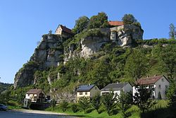
520:. It nestles at the convergence of the Püttlach, Weihersbach and Haselbrunn valleys surrounded by high cliffs and at the foot of the 1000-year-old
666:
Genesis Online-Datenbank des
Bayerischen Landesamtes für Statistik Tabelle 12411-003r Fortschreibung des Bevölkerungsstandes: Gemeinden, Stichtag
653:
139:
501:
925:
535:
From 1935 to 1945 and again from 1953 to 1972 Hans
Dippold was the mayor of Pottenstein. The farmer and restaurant keeper joined the
554:
424:
157:
487:
508:
958:
189:
589:
765:
953:
404:
140:
58:
601:
434:
41:
948:
412:
613:
516:
The city of
Pottenstein, altitude 350–614 m AMSL, with its nearly 1,500 inhabitants, is a health-resort in
815:
517:
825:
383:
800:
561:. Since 2004 there has been a marked walking route through the town, known as the "Elisabeth Route".
558:
550:
393:
290:
283:
855:
744:
678:
574:
459:
295:
712:
521:
46:
266:
649:
845:
278:
374:
780:
910:
895:
865:
942:
900:
905:
890:
830:
795:
870:
820:
770:
915:
850:
790:
785:
650:
Liste der ersten Bürgermeister/Oberbürgermeister in kreisangehörigen
Gemeinden
536:
400:
379:
239:
226:
860:
840:
475:
760:
835:
775:
755:
471:
306:
885:
805:
467:
463:
271:
259:
810:
631:
Yearly resolution of the
Eternal Adoration (The Festival of Lights)
524:, which has played an important role throughout the city's history.
875:
319:
32:
716:
447:
924:
707:
77:
443:
433:
423:
411:
390:
373:
365:
357:
352:
344:
336:
331:
317:
312:
301:
289:
277:
265:
255:
74:
21:
668:(Einwohnerzahlen auf Grundlage des Zensus 2011).
81:
694:bei nordbayern.de, retrieved 14 December 2015.
728:
692:Ein Pottensteiner Urgestein feiert seinen 70.
8:
735:
721:
713:
18:
470:. It is situated 23 km southwest of
642:
585:
511:A panorama of Pottenstein from the east
442:
410:
372:
351:
343:
330:
311:
300:
254:
219:
149:
70:
52:
38:
432:
422:
389:
364:
356:
340:73.24 km (28.28 sq mi)
335:
316:
288:
276:
264:
7:
654:Bayerisches Landesamt für Statistik
196:
164:
486:During World War II, a subcamp of
14:
929:Coat of Arms of Bayreuth district
555:Ludwig IV, Landgrave of Thuringia
624:
612:
600:
588:
500:
195:
188:
163:
156:
57:
40:
577:(1868-1947), Jesuit and mystic
569:Sons and daughters of the town
488:Flossenbürg concentration camp
1:
743:Towns and municipalities in
975:
607:Main Street in Pottenstein
348:368 m (1,207 ft)
922:
751:
656:. Retrieved 13 June 2024.
474:, and 26 km east of
220:
150:
71:
53:
39:
30:
595:City Hall in Pottenstein
16:Town in Bavaria, Germany
959:Franconian Switzerland
930:
518:Franconian Switzerland
369:71/km (180/sq mi)
143:
928:
392: • Summer (
240:49.77222°N 11.41139°E
142:
708:Municipality website
559:Miracle of the Roses
460:district of Bayreuth
435:Vehicle registration
366: • Density
954:Bayreuth (district)
745:Bayreuth (district)
680:Concentration Camps
677:Christine O'Keefe.
575:Johann Baptist Reus
546:Tourist attractions
236: /
211:Show map of Bavaria
179:Show map of Germany
931:
619:Pottenstein Castle
490:was located here.
448:www.pottenstein.de
358: • Total
337: • Total
245:49.77222; 11.41139
144:
47:Pottenstein Castle
936:
935:
458:is a town in the
453:
452:
966:
949:Towns in Bavaria
846:Kirchenpingarten
737:
730:
723:
714:
695:
689:
683:
675:
669:
663:
657:
647:
628:
616:
604:
592:
504:
397:
324:
323:(2024–30)
251:
250:
248:
247:
246:
241:
237:
234:
233:
232:
229:
212:
205:
199:
198:
192:
180:
173:
167:
166:
160:
80:
61:
44:
25:
19:
974:
973:
969:
968:
967:
965:
964:
963:
939:
938:
937:
932:
920:
747:
741:
704:
699:
698:
690:
686:
676:
672:
664:
660:
648:
644:
639:
632:
629:
620:
617:
608:
605:
596:
593:
584:
571:
551:Saint Elisabeth
548:
542:
530:
514:
513:
512:
510:
505:
496:
484:
419:
391:
327:Christian Weber
322:
244:
242:
238:
235:
230:
227:
225:
223:
222:
216:
215:
214:
213:
210:
209:
208:
207:
206:
203:
200:
183:
182:
181:
178:
177:
176:
175:
174:
171:
168:
146:
145:
141:
78:
75:
67:
66:
65:
64:
49:
35:
26:
23:
17:
12:
11:
5:
972:
970:
962:
961:
956:
951:
941:
940:
934:
933:
923:
921:
919:
918:
913:
911:Warmensteinach
908:
903:
898:
896:Seybothenreuth
893:
888:
883:
878:
873:
868:
863:
858:
853:
848:
843:
838:
833:
828:
823:
818:
813:
808:
803:
798:
793:
788:
783:
778:
773:
768:
763:
758:
752:
749:
748:
742:
740:
739:
732:
725:
717:
711:
710:
703:
702:External links
700:
697:
696:
684:
670:
658:
641:
640:
638:
635:
634:
633:
630:
623:
621:
618:
611:
609:
606:
599:
597:
594:
587:
583:
580:
579:
578:
570:
567:
547:
544:
529:
526:
507:
506:
499:
498:
497:
495:
492:
483:
480:
451:
450:
445:
441:
440:
437:
431:
430:
427:
425:Dialling codes
421:
420:
417:
415:
409:
408:
398:
388:
387:
377:
371:
370:
367:
363:
362:
359:
355:
354:
350:
349:
346:
342:
341:
338:
334:
333:
329:
328:
325:
315:
314:
310:
309:
303:
299:
298:
293:
287:
286:
281:
275:
274:
269:
263:
262:
257:
253:
252:
218:
217:
202:
201:
194:
193:
187:
186:
185:
184:
170:
169:
162:
161:
155:
154:
153:
152:
151:
148:
147:
76:
73:
72:
69:
68:
62:
56:
55:
54:
51:
50:
45:
37:
36:
31:
28:
27:
22:
15:
13:
10:
9:
6:
4:
3:
2:
971:
960:
957:
955:
952:
950:
947:
946:
944:
927:
917:
914:
912:
909:
907:
904:
902:
901:Speichersdorf
899:
897:
894:
892:
889:
887:
884:
882:
879:
877:
874:
872:
869:
867:
864:
862:
859:
857:
854:
852:
849:
847:
844:
842:
839:
837:
834:
832:
829:
827:
824:
822:
819:
817:
814:
812:
809:
807:
804:
802:
799:
797:
794:
792:
789:
787:
784:
782:
779:
777:
774:
772:
769:
767:
764:
762:
759:
757:
754:
753:
750:
746:
738:
733:
731:
726:
724:
719:
718:
715:
709:
706:
705:
701:
693:
688:
685:
682:
681:
674:
671:
667:
662:
659:
655:
651:
646:
643:
636:
627:
622:
615:
610:
603:
598:
591:
586:
581:
576:
573:
572:
568:
566:
562:
560:
556:
552:
545:
543:
540:
538:
533:
527:
525:
523:
519:
509:
503:
493:
491:
489:
481:
479:
477:
473:
469:
465:
461:
457:
449:
446:
438:
436:
428:
426:
416:
414:
406:
402:
399:
395:
385:
381:
378:
376:
368:
360:
347:
339:
326:
321:
318: •
308:
304:
297:
294:
292:
285:
284:Oberfranken
282:
280:
279:Admin. region
273:
270:
268:
261:
258:
249:
221:Coordinates:
191:
159:
60:
48:
43:
34:
29:
20:
906:Waischenfeld
891:Schnabelwaid
880:
831:Heinersreuth
796:Emtmannsberg
781:Bischofsgrün
687:
679:
673:
661:
645:
563:
549:
541:
534:
531:
515:
485:
455:
454:
413:Postal codes
302:Subdivisions
204:Pottenstein
172:Pottenstein
63:Coat of arms
24:Pottenstein
881:Pottenstein
871:Plankenfels
821:Goldkronach
801:Fichtelberg
771:Betzenstein
766:Bad Berneck
553:, widow of
456:Pottenstein
243: /
943:Categories
916:Weidenberg
856:Mistelbach
851:Mehlmeisel
816:Glashütten
791:Eckersdorf
637:References
537:Nazi Party
353:Population
313:Government
296:Bayreuth
231:11°24′41″E
228:49°46′20″N
861:Mistelgau
841:Hummeltal
539:in 1931.
494:Geography
476:Forchheim
401:UTC+02:00
380:UTC+01:00
375:Time zone
345:Elevation
307:Ortsteile
836:Hollfeld
776:Bindlach
756:Ahorntal
472:Bayreuth
291:District
886:Prebitz
866:Pegnitz
806:Gefrees
786:Creußen
582:Gallery
482:History
468:Germany
464:Bavaria
444:Website
272:Bavaria
260:Germany
256:Country
811:Gesees
761:Aufseß
528:Mayors
522:castle
876:Plech
462:, in
429:09243
418:91278
361:5,225
320:Mayor
267:State
826:Haag
405:CEST
332:Area
33:Town
394:DST
384:CET
305:32
945::
652:,
478:.
466:,
439:BT
736:e
729:t
722:v
407:)
403:(
396:)
386:)
382:(
Text is available under the Creative Commons Attribution-ShareAlike License. Additional terms may apply.