36:
133:
173:
140:
166:
339:
370:
danger. During winter months, weather is usually cloudy, but due to high pressure systems over the
Pacific Ocean that intensify during summer months, there is often little or no cloud cover during the summer. Due to its temperate climate and proximity to the Pacific Ocean, areas west of the Cascade
362:), causing them to drop their moisture in the form of rain or snowfall onto the Cascades. As a result, the west side of the North Cascades experiences high precipitation, especially during the winter months in the form of snowfall. Because of
387:. Geological events occurring many years ago created the diverse topography and drastic elevation changes over the Cascade Range leading to the various climate differences. These climate differences lead to vegetation variety defining the
433:
period dating back over two million years ago, glaciation advancing and retreating repeatedly scoured the landscape leaving deposits of rock debris. The U-shaped cross section of the river valleys is a result of recent glaciation.
88:
625:
635:
132:
165:
620:
522:
640:
442:
in combination with glaciation have been the dominant processes which have created the tall peaks and deep valleys of the North
Cascades area.
307:
513:
518:
246:
35:
220:
81:
20:
605:
508:
415:
319:
291:
268:
210:
371:
Crest very rarely experience temperatures below 0 °F (−18 °C) or above 80 °F (27 °C).
630:
295:
61:
71:
563:
Beckey, Fred W. Cascade Alpine Guide, Climbing and High Routes. Seattle, WA: Mountaineers Books, 2008.
338:
599:
399:
311:
411:
394:
The history of the formation of the
Cascade Mountains dates back millions of years ago to the late
358:. As fronts approach the North Cascades, they are forced upward by the peaks of the Cascade Range (
355:
347:
287:
439:
363:
359:
241:
423:
384:
323:
315:
283:
227:
614:
403:
380:
351:
303:
282:
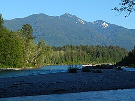
is a 5,678-foot-elevation (1,731 meter) mountain summit near the western edge of the
234:
327:
299:
261:
466:
430:
271:
103:
90:
388:
367:
330:. The mountain was so named because of the beautiful prairie at its base.
435:
419:
407:
379:
The North
Cascades features some of the most rugged topography in the
484:
395:
51:
314:, 4.7 miles (7.6 km) to the south-southeast. Precipitation
354:
originating in the
Pacific Ocean travel northeast toward the
559:
557:
555:
553:
551:
366:, snow tends to be wet and heavy, resulting in high
260:
255:
240:
226:
216:
206:
198:
119:
80:
70:
60:
50:
45:
28:
410:persisted. In addition, small fragments of the
545:, University of Washington Press, 1923, pg. 230
306:. It is situated on land administered by the
16:Mountain in Washington (state), United States
8:
575:
573:
571:
569:
350:climate zone of western North America. Most
582:The Natural History of Puget Sound Country
25:
626:Mountains of Snohomish County, Washington
523:United States Department of the Interior
337:
172:
139:
451:
294:state. It is located six miles east of
636:Mount Baker-Snoqualmie National Forest
318:from Prairie Mountain drains into the
308:Mount Baker-Snoqualmie National Forest
543:Origin of Washington Geographic Names
40:Prairie Mountain seen with Sauk River
7:
461:
459:
457:
455:
383:with craggy peaks, ridges, and deep
185:Prairie Mountain (the United States)
514:Geographic Names Information System
346:Prairie Mountain is located in the
14:
584:. University of Washington Press.
342:Prairie Mountain from Highway 530
171:
164:
138:
131:
34:
19:For the mountain in Canada, see
621:Mountains of Washington (state)
519:United States Geological Survey
485:"Prairie Mountain - 5,678' WA"
467:"Prairie Mountain, Washington"
155:Show map of Washington (state)
1:
641:North American 1000 m summits
310:. The nearest higher peak is
188:Show map of the United States
426:about 50 million years ago.
302:which is one of the Cascade
56:5,678 ft (1,731 m)
580:Kruckeberg, Arthur (1991).
76:4.87 mi (7.84 km)
657:
326:, both tributaries of the
66:1,358 ft (414 m)
21:Prairie Mountain (Alberta)
18:
408:volcanic igneous activity
124:
33:
604:Prairie Mountain photo:
104:48.275179°N 121.471161°W
416:continental lithosphere
343:
296:Darrington, Washington
152:Location in Washington
109:48.275179; -121.471161
341:
400:North American Plate
312:White Chuck Mountain
598:Mountain Forecast:
298:, and northwest of
100: /
509:"Prairie Mountain"
364:maritime influence
344:
46:Highest point
541:Edmond S. Meany,
356:Cascade Mountains
348:marine west coast
277:
276:
648:
600:Prairie Mountain
586:
585:
577:
564:
561:
546:
539:
533:
532:
530:
529:
505:
499:
498:
496:
495:
481:
475:
474:
463:
398:Epoch. With the
288:Snohomish County
280:Prairie Mountain
264:
250:Prairie Mountain
230:
189:
179:Prairie Mountain
175:
174:
168:
156:
146:Prairie Mountain
142:
141:
135:
115:
114:
112:
111:
110:
105:
101:
98:
97:
96:
93:
38:
29:Prairie Mountain
26:
656:
655:
651:
650:
649:
647:
646:
645:
611:
610:
595:
590:
589:
579:
578:
567:
562:
549:
540:
536:
527:
525:
507:
506:
502:
493:
491:
489:listsofjohn.com
483:
482:
478:
465:
464:
453:
448:
402:overriding the
385:glacial valleys
377:
360:orographic lift
336:
304:stratovolcanoes
262:
228:
194:
193:
192:
191:
190:
187:
186:
183:
182:
181:
180:
176:
159:
158:
157:
154:
153:
150:
149:
148:
147:
143:
108:
106:
102:
99:
94:
91:
89:
87:
86:
41:
24:
17:
12:
11:
5:
654:
652:
644:
643:
638:
633:
628:
623:
613:
612:
609:
608:
602:
594:
593:External links
591:
588:
587:
565:
547:
534:
500:
476:
471:Peakbagger.com
450:
449:
447:
444:
424:North Cascades
406:, episodes of
391:in this area.
376:
373:
352:weather fronts
335:
332:
324:Suiattle River
284:North Cascades
275:
274:
266:
258:
257:
253:
252:
244:
238:
237:
232:
224:
223:
218:
214:
213:
208:
204:
203:
200:
196:
195:
184:
178:
177:
170:
169:
163:
162:
161:
160:
151:
145:
144:
137:
136:
130:
129:
128:
127:
126:
125:
122:
121:
117:
116:
84:
78:
77:
74:
68:
67:
64:
58:
57:
54:
48:
47:
43:
42:
39:
31:
30:
15:
13:
10:
9:
6:
4:
3:
2:
653:
642:
639:
637:
634:
632:
631:Cascade Range
629:
627:
624:
622:
619:
618:
616:
607:
603:
601:
597:
596:
592:
583:
576:
574:
572:
570:
566:
560:
558:
556:
554:
552:
548:
544:
538:
535:
524:
520:
516:
515:
510:
504:
501:
490:
486:
480:
477:
472:
468:
462:
460:
458:
456:
452:
445:
443:
441:
437:
432:
427:
425:
421:
417:
413:
409:
405:
404:Pacific Plate
401:
397:
392:
390:
386:
382:
381:Cascade Range
374:
372:
369:
365:
361:
357:
353:
349:
340:
333:
331:
329:
325:
321:
317:
313:
309:
305:
301:
297:
293:
289:
285:
281:
273:
270:
267:
265:
263:Easiest route
259:
254:
251:
248:
245:
243:
239:
236:
235:Cascade Range
233:
231:
225:
222:
219:
215:
212:
209:
205:
202:United States
201:
197:
167:
134:
123:
118:
113:
85:
83:
79:
75:
73:
69:
65:
63:
59:
55:
53:
49:
44:
37:
32:
27:
22:
581:
542:
537:
526:. Retrieved
512:
503:
492:. Retrieved
488:
479:
470:
428:
422:created the
393:
378:
345:
328:Skagit River
300:Glacier Peak
279:
278:
269:class 3
249:
229:Parent range
431:Pleistocene
429:During the
107: /
95:121°28′16″W
82:Coordinates
615:Categories
528:2021-03-02
494:2021-03-02
446:References
389:ecoregions
320:Sauk River
292:Washington
272:scrambling
211:Washington
92:48°16′31″N
62:Prominence
368:avalanche
221:Snohomish
120:Geography
72:Isolation
52:Elevation
440:faulting
420:terranes
256:Climbing
242:Topo map
418:called
412:oceanic
375:Geology
334:Climate
199:Country
606:Flickr
436:Uplift
396:Eocene
316:runoff
217:County
286:, in
207:State
438:and
414:and
322:and
247:USGS
290:of
617::
568:^
550:^
521:,
517:.
511:.
487:.
469:.
454:^
531:.
497:.
473:.
23:.
Text is available under the Creative Commons Attribution-ShareAlike License. Additional terms may apply.