472:
92:
460:
125:
38:
448:
436:
63:
53:
132:
99:
78:
403:. By royal decree Prinsenbeek was given a town arms on 12 January 1951 and on 11 October 1963 the town council decided to have a town flag. On 1 July 1976 the area east of the railway was added to Breda to construct the district of
558:
395:
was added to the town Breda. The village, with a church, became a separate municipality. In 1951 the name was changed into
Prinsenbeek, because there were several more towns called Beek, one in
384:) at Beek was built in the 14th century, and that is the first mention of this village. Beek became a parish in 1796. On 1 July 1866 the train station Prinsenbeek was opened.
471:
91:
563:
568:
302:
418:
The
Mariachapel was built in 1953, and renamed in 1980 into 'Chapel of Peace', in remembrance of the people who died in the second World War.
415:
Prinsenbeek has some civil monuments. The pump at the Markt is a reconstruction from 1975 of the pump from 1874, which was destroyed in 1935.
314:
124:
459:
160:
447:
37:
294:
62:
435:
52:
396:
273:
283:
77:
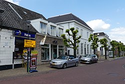
501:
407:. Finally at the municipal redivision on 1 January 1997 Prinsenbeek was added to Breda.
573:
404:
552:
361:
333:
205:
388:
392:
329:
195:
400:
175:
162:
349:
337:
264:
365:
341:
424:
A sculpture of a slowtrain, which was used to drive on the railroad.
290:
269:
357:
353:
215:
526:
345:
111:
Location in the province of North
Brabant in the Netherlands
559:
Municipalities of the
Netherlands disestablished in 1997
368:, Prinsenbeek is called Boemeldonck (slowtrainswamp).
336:. The village is situated west of the motorway A16 (
360:, and it has 11,419 inhabitants (2005). There is a
313:
301:
280:
263:
255:
247:
242:
234:
226:
221:
211:
201:
191:
21:
387:The municipality Beek was founded in 1942, during
328:is a village and a former municipality in the
8:
356:. Prinsenbeek is a part of the municipality
18:
421:The church, built on the Market square.
364:on the line Rotterdam–Breda. During the
488:
431:
300:
262:
241:
233:
220:
190:
155:
83:
74:
46:
34:
564:Former municipalities of North Brabant
496:
494:
492:
312:
279:
254:
246:
225:
210:
200:
7:
502:"Kerncijfers wijken en buurten 2021"
230:17.11 km (6.61 sq mi)
131:
98:
376:Initially, the village was called
16:Town in North Brabant, Netherlands
14:
569:Populated places in North Brabant
470:
458:
446:
434:
130:
123:
97:
90:
76:
61:
51:
36:
533:(in Dutch). Het Waterschapshuis
531:Actueel Hoogtebestand Nederland
1:
506:Central Bureau of Statistics
590:
527:"Postcodetool for 4841AA"
259:710/km (1,800/sq mi)
156:
144:Prinsenbeek (Netherlands)
114:Show map of North Brabant
84:
75:
47:
35:
28:
147:Show map of Netherlands
477:Church of Prinsenbeek
465:Market in Prinsenbeek
453:Bakery in Prinsenbeek
282: • Summer (
238:4 m (13 ft)
42:Street of Prinsenbeek
380:. The Prinsenhoeve (
256: • Density
441:Farm in Prinsenbeek
172: /
248: • Total
227: • Total
323:
322:
581:
543:
542:
540:
538:
523:
517:
516:
514:
512:
498:
474:
462:
450:
438:
391:, when the town
287:
187:
186:
184:
183:
182:
177:
176:51.600°N 4.717°E
173:
170:
169:
168:
165:
148:
134:
133:
127:
115:
101:
100:
94:
80:
65:
55:
40:
19:
589:
588:
584:
583:
582:
580:
579:
578:
549:
548:
547:
546:
536:
534:
525:
524:
520:
510:
508:
500:
499:
490:
485:
478:
475:
466:
463:
454:
451:
442:
439:
430:
413:
374:
309:
281:
180:
178:
174:
171:
166:
163:
161:
159:
158:
152:
151:
150:
149:
146:
145:
142:
141:
140:
139:
135:
118:
117:
116:
113:
112:
109:
108:
107:
106:
102:
71:
70:
69:
68:
59:
58:
43:
31:
24:
17:
12:
11:
5:
587:
585:
577:
576:
571:
566:
561:
551:
550:
545:
544:
518:
487:
486:
484:
481:
480:
479:
476:
469:
467:
464:
457:
455:
452:
445:
443:
440:
433:
429:
426:
412:
409:
405:Haagse Beemden
373:
370:
321:
320:
317:
311:
310:
307:
305:
299:
298:
288:
278:
277:
267:
261:
260:
257:
253:
252:
249:
245:
244:
240:
239:
236:
232:
231:
228:
224:
223:
219:
218:
213:
209:
208:
203:
199:
198:
193:
189:
188:
154:
153:
143:
137:
136:
129:
128:
122:
121:
120:
119:
110:
104:
103:
96:
95:
89:
88:
87:
86:
85:
82:
81:
73:
72:
66:
60:
56:
50:
49:
48:
45:
44:
41:
33:
32:
29:
26:
25:
22:
15:
13:
10:
9:
6:
4:
3:
2:
586:
575:
572:
570:
567:
565:
562:
560:
557:
556:
554:
532:
528:
522:
519:
507:
503:
497:
495:
493:
489:
482:
473:
468:
461:
456:
449:
444:
437:
432:
427:
425:
422:
419:
416:
410:
408:
406:
402:
398:
394:
390:
385:
383:
382:princes' farm
379:
371:
369:
367:
363:
362:train station
359:
355:
351:
347:
343:
339:
335:
334:North Brabant
331:
327:
318:
316:
306:
304:
296:
292:
289:
285:
275:
271:
268:
266:
258:
250:
237:
229:
217:
214:
207:
206:North Brabant
204:
197:
194:
185:
181:51.600; 4.717
157:Coordinates:
126:
93:
79:
64:
54:
39:
27:
20:
535:. Retrieved
530:
521:
509:. Retrieved
505:
423:
420:
417:
414:
389:World War II
386:
381:
377:
375:
325:
324:
315:Dialing code
212:Municipality
67:Coat of arms
399:and one in
393:Princenhage
326:Prinsenbeek
303:Postal code
196:Netherlands
179: /
138:Prinsenbeek
105:Prinsenbeek
23:Prinsenbeek
553:Categories
483:References
401:Gelderland
344:) and the
243:Population
411:Buildings
350:Amsterdam
338:Rotterdam
332:province
265:Time zone
235:Elevation
537:15 April
511:15 April
366:carnival
202:Province
428:Gallery
397:Limburg
372:History
342:Antwerp
192:Country
164:51°36′N
251:12,140
167:4°43′E
574:Breda
358:Breda
354:Paris
348:line
330:Dutch
291:UTC+2
270:UTC+1
216:Breda
539:2022
513:2022
378:Beek
308:4841
295:CEST
222:Area
57:Flag
30:Town
346:TGV
319:076
284:DST
274:CET
555::
529:.
504:.
491:^
541:.
515:.
352:–
340:–
297:)
293:(
286:)
276:)
272:(
Text is available under the Creative Commons Attribution-ShareAlike License. Additional terms may apply.