344:
91:
74:
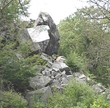
to be used as a state park tourist attraction. In recent years, the site has been frequently vandalized with graffiti, despite an aggressive cleanup effort by the
Bristol County Sheriff. On June 19, 2019, at approximately 9:22 a.m., the Freetown Police Department, along with the Freetown Fire
78:
State forest officials have closed the park until further notice due to the unsafe environment. The public is encouraged to stay away from the area. As of July 31, 2023 you can go inside the park, but the inside is still a mess with graffiti all over the place.
25:
75:
Department, responded to the
Freetown State Forest “Profile Rock” Park for a report of recent damages to the historic rock formation. First responders and park officials discovered that a large portion of the rock formation had broken off.
70:
Joshua's
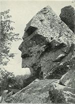
Mountain was named after Joshua Tisdale, who was the first to settle near the site. It was privately owned for several years by former Freetown Selectman Ben Evans, who sold it to the
429:
414:
385:
104:
424:
404:
17:
378:
225:
409:
212:
the (Graffiti Unit) crew has made frequent trips out to
Profile Rock ... and they'll keep making those trips wherever graffiti is found
371:
150:
419:
351:
343:
71:
67:
to the west and the
Atlantic Ocean to the east, and Chief Massasoit was a close friend to the early Pilgrim settlers.
305:
114:
125:
40:
44:
48:
96:
120:
130:
173:
64:
52:
199:
355:
16:
186:
residents ... have noticed an uptick in debris and graffiti at the (Profile Rock) site
398:
60:
24:
248:
289:
109:
86:
320:
307:
151:"Freetown Police search for suspects who spray painted their names on rocks"
56:
275:
23:
15:
226:"Large chunk of Profile Rock in Freetown comes crashing down"
359:
39:) was a 50-foot high granite rock formation located in
105:List of rock formations that resemble human beings
249:"WHAT FREETOWN'S PROFILE ROCK LOOKS LIKE TODAY"
174:"Residents aim to fight Profile Rock vandalism"
430:Bristol County, Massachusetts geography stubs
379:
8:
415:Landforms of Bristol County, Massachusetts
386:
372:
20:A 1902 postcard photo showing Profile Rock
200:"Cleanup Of Profile Rock Almost Complete"
425:Native American history of Massachusetts
59:. The Wampanoags occupied the region of
142:
7:
340:
338:
55:believe it to be the image of Chief
247:Richard, Barry (18 January 2023).
14:
198:McCready, Dan (15 October 2015).
172:Wagner, Jeffrey (16 April 2013).
405:Rock formations of Massachusetts
342:
117:, location of the "Face on Mars"
89:
354:geography–related article is a
153:. 7 News Boston. 28 March 2016
1:
352:Bristol County, Massachusetts
72:Commonwealth of Massachusetts
63:and Massachusetts bounded by
358:. You can help Knowledge by
37:Old Man of Joshua's Mountain
224:Roy, Linda (19 June 2019).
446:
410:Landmarks in Massachusetts
337:
420:Freetown, Massachusetts
176:. Taunton Daily Gazette
126:Old Man of the Mountain
41:Freetown, Massachusetts
29:
21:
321:41.79583°N 71.05500°W
228:. SouthCoastToday.com
49:Freetown State Forest
47:village and near the
27:
19:
97:New Hampshire portal
326:41.79583; -71.05500
317: /
121:Old Man of the Lake
35:(also known as the
131:Mount Pemigewasset
30:
28:Profile Rock, 2008
22:
367:
366:
437:
388:
381:
374:
346:
339:
332:
331:
329:
328:
327:
322:
318:
315:
314:
313:
310:
299:
297:
296:
285:
283:
282:
261:
260:
258:
256:
244:
238:
237:
235:
233:
221:
215:
214:
209:
207:
195:
189:
188:
183:
181:
169:
163:
162:
160:
158:
147:
99:
94:
93:
92:
65:Narragansett Bay
445:
444:
440:
439:
438:
436:
435:
434:
395:
394:
393:
392:
335:
325:
323:
319:
316:
311:
308:
306:
304:
303:
294:
292:
288:
280:
278:
274:Frank W. Wing.
273:
270:
265:
264:
254:
252:
246:
245:
241:
231:
229:
223:
222:
218:
205:
203:
197:
196:
192:
179:
177:
171:
170:
166:
156:
154:
149:
148:
144:
139:
95:
90:
88:
85:
12:
11:
5:
443:
441:
433:
432:
427:
422:
417:
412:
407:
397:
396:
391:
390:
383:
376:
368:
365:
364:
347:
301:
300:
286:
276:"Profile Rock"
269:
268:External links
266:
263:
262:
239:
216:
190:
164:
141:
140:
138:
135:
134:
133:
128:
123:
118:
112:
107:
101:
100:
84:
81:
13:
10:
9:
6:
4:
3:
2:
442:
431:
428:
426:
423:
421:
418:
416:
413:
411:
408:
406:
403:
402:
400:
389:
384:
382:
377:
375:
370:
369:
363:
361:
357:
353:
348:
345:
341:
336:
333:
330:
291:
287:
277:
272:
271:
267:
250:
243:
240:
227:
220:
217:
213:
201:
194:
191:
187:
175:
168:
165:
152:
146:
143:
136:
132:
129:
127:
124:
122:
119:
116:
113:
111:
108:
106:
103:
102:
98:
87:
82:
80:
76:
73:
68:
66:
62:
58:
54:
50:
46:
43:just outside
42:
38:
34:
26:
18:
360:expanding it
349:
334:
302:
293:. Retrieved
279:. Retrieved
253:. Retrieved
242:
230:. Retrieved
219:
211:
204:. Retrieved
193:
185:
178:. Retrieved
167:
155:. Retrieved
145:
77:
69:
61:Rhode Island
36:
33:Profile Rock
32:
31:
324: /
290:"Wampanoag"
202:. 1420 WBSM
399:Categories
312:71°03′18″W
309:41°47′45″N
295:2008-07-18
281:2008-07-17
255:18 January
137:References
110:Pareidolia
53:Wampanoags
57:Massasoit
83:See also
51:. Local
232:19 June
115:Cydonia
45:Assonet
251:. WBSM
206:5 July
180:5 July
157:5 July
350:This
356:stub
257:2023
234:2019
208:2016
182:2016
159:2016
401::
210:.
184:.
387:e
380:t
373:v
362:.
298:.
284:.
259:.
236:.
161:.
Text is available under the Creative Commons Attribution-ShareAlike License. Additional terms may apply.