732:
58:
1397:
1401:
125:
564:
2717:
1964:
151:
142:
787:
Additional highways serving the area include Route 146 (connecting
Providence and Worcester), Route 138 (serving Newport), Route 24 (connecting Fall River and Newport with the Boston area), Route 4 (serving the Wickford area), Route 99 (connecting Route 146 with Woonsocket) and Route 140 (connecting
695:, manages local bus transit for the state, serving 35 out of 39 Rhode Island communities as well as South Attleboro and Seekonk, Massachusetts. RIPTA operates 55 bus lines as well as Flex service and paratransit service. Ferry services link
1040:
populations exist across the region, particularly the area from East
Providence to New Bedford. The two Bristol counties (RI and MA) are the only counties in the U.S. in which Portuguese-Americans are the largest ancestry group.
2772:
Core cities are metropolitan core cities of at least a million people. The other areas are urban areas of cities that have an urban area of 150,000+ or of a metropolitan area of at least 250,000+. Satellite cities are in
385:
The
Providence-Warwick, RI-MA Metropolitan Statistical Area (defined at the county level by the US Census Bureau) contains all five counties in Rhode Island and one county in Massachusetts, namely:
3009:
1502:
2960:
716:
1487:
369:
2753:
2121:
3319:
3232:
1572:
646:. Full completion of Phase II of the project, via the Stoughton branch, is expected by 2030, with a new seasonal stop opening on Fall River's waterfront at
3314:
1540:
781:
774:
3064:
1474:
57:
1297:
580:
2051:
2046:
335:
1265:
2701:
2402:
2041:
2000:
1497:
712:
761:
passes through T.F. Green and connects the airport to
Providence and Boston, offering additional airport flexibility in the Greater Boston Area.
1791:
1738:
1535:
1441:
247:
3309:
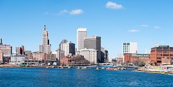
2177:
1375:
778:
684:
3324:
2212:
2091:
1643:
1312:
2746:
2106:
1135:
2126:
1562:
1530:
692:
3334:
3329:
3220:
2313:
2116:
2101:
1068:
600:
524:
3290:
2321:
2081:
1652:
1552:
608:
2675:
2386:
2361:
2356:
2326:
2152:
2111:
1680:
1675:
1522:
665:
616:
492:
475:
409:
404:
3339:
2739:
2475:
2376:
2346:
2147:
1899:
1894:
1593:
592:
471:
334:. With an estimated population of 1,622,520, exceeding that of Rhode Island by slightly over 60%, the Providence MSA is the
2381:
2371:
2351:
2331:
2187:
2162:
1924:
1889:
1756:
1063:
770:
612:
520:
506:
424:
414:
343:
73:
43:
2948:
2906:
2237:
2192:
1939:
1869:
1829:
1670:
1660:
639:
399:
389:
3031:
2792:
2341:
2336:
2280:
2276:
2263:
2071:
1993:
1746:
1628:
754:
720:
3270:
3237:
3194:
2917:
2854:
2650:
2645:
2600:
2595:
2585:
2580:
2560:
2480:
2450:
2302:
2268:
2172:
2061:
2056:
1944:
1884:
1879:
1809:
1512:
1434:
444:
350:
175:
731:
3184:
3145:
2997:
2943:
2640:
2615:
2540:
2520:
2515:
2500:
2490:
2430:
2233:
2197:
2182:
2142:
2009:
1814:
1665:
1002:
987:
972:
957:
942:
927:
912:
897:
882:
867:
852:
837:
822:
758:
704:
584:
548:
514:
510:
496:
439:
394:
365:
180:
101:
3275:
3249:
3127:
3102:
2965:
2835:
2695:
2670:
2665:
2525:
2495:
2460:
2445:
2425:
2167:
2076:
2066:
2033:
1919:
1904:
1874:
1824:
1799:
1781:
1771:
1633:
1623:
1588:
1464:
1192:
596:
528:
500:
459:
429:
331:
164:
118:
86:
63:
3215:
3155:
2986:
2982:
2972:
2894:
2872:
2685:
2680:
2625:
2535:
2505:
2470:
2455:
2420:
2202:
1854:
1849:
1844:
1766:
1603:
1517:
1482:
647:
552:
544:
536:
434:
190:
3244:
3204:
3014:
2846:
2660:
2655:
2610:
2575:
2570:
2565:
2530:
2510:
2485:
2465:
2435:
2415:
2157:
2096:
1986:
1949:
1929:
1914:
1909:
1859:
1819:
1751:
1724:
540:
532:
486:
454:
195:
17:
1357:
3189:
3160:
3115:
3026:
2886:
2762:
2690:
2630:
2620:
2605:
2590:
2555:
2545:
2410:
2286:
2225:
1864:
1804:
1776:
1761:
1598:
1427:
1272:
750:
739:
708:
604:
449:
185:
1107:
3211:
3177:
3165:
2990:
2953:
2924:
2879:
2822:
2721:
2635:
2086:
1934:
1839:
1834:
707:
to the Rhode Island mainland. Additionally, there is a seasonal ferry service between
Providence and
294:
3043:
3036:
2550:
1968:
1547:
1082:
1037:
746:
735:
643:
354:
715:(SRTA) provides local bus service in the Massachusetts locales of Fall River and New Bedford. The
622:
An extension of the
Stoughton branch to Fall River and New Bedford is also planned as part of the
3150:
3048:
3019:
2899:
2865:
2815:
669:
661:
657:
635:
588:
568:
1398:"Bristol County, Massachusetts – Select a Race, Ethnic, or Ancestry Group – American FactFinder"
1316:
3199:
2840:
2392:
2294:
2229:
1698:
1567:
1492:
1291:
773:, which runs diagonally across Rhode Island and connecting with Boston and New York City, and
305:
284:
1142:
719:
serves much of the
Massachusetts portion of the metropolitan area, and areas eastward to the
478:) does not include the separate New Bedford NECTA, but they are unified in a Combined NECTA.
3110:
2911:
2731:
2253:
1719:
1216:"Providence: Least Sprawling Metropolitan Area: Colorado Springs Sprawls less than Portland"
631:
627:
623:
563:
124:
3225:
3172:
2804:
700:
626:
project. Phase I is expected to be completed in 2024, with trains running via the current
3265:
3091:
3002:
2298:
2290:
2248:
2243:
362:
150:
3303:
2977:
2859:
2830:
2013:
1240:
688:
327:
154:
128:
141:
2809:
1703:
1690:
1618:
1613:
1608:
1507:
1454:
696:
361:. Since 2006, the Providence metropolitan area has been officially included in the
339:
323:
145:
1313:"Current Lists of Metropolitan and Micropolitan Statistical Areas and Definitions"
587:
connecting the metropolitan area to Boston. Existing
Providence line stations in
1978:
1058:
583:(MBTA) operates commuter rail in the region, with the Providence branch of the
1450:
319:
318:(Providence MSA) is a region extending into eight counties in two states. Its
135:
1170:
301:
280:
2797:
2700:
Note: Municipalities not listed have a town meeting form of government (see
2366:
2258:
1557:
1376:"Annual Estimates of the Resident Population: April 1, 2010 to July 1, 2019"
1215:
275:
2272:
2220:
1419:
777:, which runs east from Providence into Fall River and New Bedford. The
3096:
2440:
2023:
653:
358:
1171:"Providence Metropolitan Area:2000–2005 Population & Migration"
1136:"Update of Statistical area Definitions and Guidance on Their Uses"
1059:"Total Gross Domestic Product for Providence-Warwick, RI-MA (MSA)"
730:
673:
562:
346:, with an average population density of 2300 per mi (888 per km).
1108:"Federal Register/Vol. 75, No. 123/Monday, June 28, 2010/Notices"
619:
on the
Providence Line was opened to the public in January 2023.
769:
Two interstates connect major population centers in the region:
353:
is the country's 42nd largest at $ 64.7 billion, just above the
2735:
1982:
1423:
1083:"2020 Census Urban Areas of the United States and Puerto Rico"
1330:
717:
Greater
Attleboro Taunton Regional Transit Authority (GATRA)
77:
1241:"May 2006 OEC Metropolitan Statistical Area definitions"
481:
The Providence-Fall River-Warwick RI-MA NECTA includes:
1141:. whitehouse.gov. pp. 52, 108, 150. Archived from
51:
Providence–Warwick, RI-MA Metropolitan Statistical Area
3258:
3138:
3084:
3077:
3057:
2936:
2785:
2778:
2401:
2312:
2211:
2135:
2032:
1790:
1737:
1712:
1689:
1651:
1642:
1581:
1473:
291:
274:
266:
261:
253:
243:
235:
230:
222:
214:
206:
201:
170:
160:
134:
117:
34:
29:Metropolitan Statistical Area in the United States
1358:"Ranking Tables for Metropolitan Areas (PHC-T-3)"
2747:
1994:
1435:
8:
1378:. United States Census Bureau. April 2, 2020
1356:DIvision, US Census Bureau Systems Support.
1165:
1163:
485:All cities and towns in Rhode Island except
338:in the United States. The MSA covers all of
3081:
2782:
2754:
2740:
2732:
2001:
1987:
1979:
1648:
1442:
1428:
1420:
795:
753:, (though its airport code is PVD) though
581:Massachusetts Bay Transportation Authority
210:1,635.76 sq mi (4,236.6 km)
31:
18:Providence, Rhode Island metropolitan area
72:Map of Greater Providence–Warwick, RI–MA
1130:
1128:
656:provides regional rail service over the
2391:Note: Nine former counties were in the
1337:. Rhode Island Public Transit Authority
1050:
713:Southeastern Regional Transit Authority
474:(defined at the municipal level by the
273:
260:
229:
221:
213:
200:
116:
100: Other Counties in the Boston, MA
69:
54:
49:
1296:: CS1 maint: archived copy as title (
1289:
815:
784:provides a bypass around Providence.
685:Rhode Island Public Transit Authority
599:were supplemented by an extension to
372:, with over eight million residents.
290:
265:
252:
242:
234:
205:
169:
159:
133:
7:
676:service is available in Providence.
672:trains stop at both stations, while
3320:Metropolitan areas of Massachusetts
1193:"July 1, 2005 Population Estimates"
94: Providence–Warwick, RI–MA MSA
3315:Metropolitan areas of Rhode Island
805:
25:
1069:Federal Reserve Bank of St. Louis
757:in Boston is also used. The MBTA
2715:
1962:
370:sixth-largest CSA in the country
149:
140:
123:
56:
617:Pawtucket/Central Falls station
493:Worcester County, Massachusetts
476:Office of Management and Budget
410:Washington County, Rhode Island
405:Providence County, Rhode Island
257:1,006.21/sq mi (380.78/km)
711:from late May to mid-October.
344:Bristol County, Massachusetts
336:38th largest metropolitan area
1:
3271:Bridgeport–Stamford–New Haven
1064:Federal Reserve Economic Data
638:, and in New Bedford at both
613:North Kingstown, Rhode Island
521:Bristol County, Massachusetts
507:Norfolk County, Massachusetts
425:East Providence, Rhode Island
415:Bristol County, Massachusetts
381:Metropolitan statistical area
44:Metropolitan Statistical Area
3310:Providence metropolitan area
788:Route 24 with New Bedford).
628:Middleborough/Lakeville Line
400:Newport County, Rhode Island
390:Bristol County, Rhode Island
316:Providence metropolitan area
36:Providence Metropolitan Area
3325:Geography of Greater Boston
3151:Bridgeport–Stamford–Norwalk
1885:New Shoreham (Block Island)
755:Logan International Airport
615:, completed in 2012. A new
3356:
2303:Quabbin-Swift River Valley
2269:Southeastern Massachusetts
445:New Bedford, Massachusetts
420:Its principal cities are:
351:Gross Metropolitan Product
218:812 ft (247.5 m)
3288:
2998:Northeastern Pennsylvania
2770:
2711:
2234:Montachusett-North County
2020:
1958:
1461:
1029:
1016:
1001:
986:
971:
956:
941:
926:
911:
896:
881:
866:
851:
836:
821:
814:
809:
804:
801:
759:Providence/Stoughton Line
585:Providence/Stoughton Line
440:Fall River, Massachusetts
395:Kent County, Rhode Island
366:Combined Statistical Area
70:
55:
50:
41:
3335:Regions of Massachusetts
3330:Providence, Rhode Island
2722:Massachusetts portal
2047:Administrative divisions
1488:Buildings and structures
460:Attleboro, Massachusetts
430:Providence, Rhode Island
332:Providence, Rhode Island
270:$ 105.561 billion (2022)
64:Providence, Rhode Island
2052:Congressional districts
1969:Rhode Island portal
435:Pawtucket, Rhode Island
357:of the entire state of
1725:Providence Plantations
742:
571:
455:Cranston, Rhode Island
330:; its largest city is
215:Highest elevation
3340:Northeast megalopolis
3010:Poughkeepsie–Newburgh
3003:Scranton/Wilkes-Barre
2763:Northeast megalopolis
2287:Western Massachusetts
2226:Central Massachusetts
797:Historical population
745:The major airport is
734:
566:
470:The Providence-based
450:Warwick, Rhode Island
293: • Summer (
223:Lowest elevation
3276:Hartford–Springfield
3065:Washington–Baltimore
2178:History of education
1278:on December 28, 2008
644:downtown New Bedford
322:is in the states of
254: • Density
226:0 ft (0 m)
2765:major urban regions
2122:Tourist attractions
1573:Visitor attractions
1548:Narragansett people
1404:on November 3, 2011
1221:. publicpurpose.com
798:
747:T. F. Green Airport
736:T. F. Green Airport
693:downtown Providence
687:(RIPTA), which has
355:Gross State Product
2702:all municipalities
1195:. US Census Bureau
1113:. US Census Bureau
1088:. US Census Bureau
796:
743:
670:Northeast Regional
658:Northeast Corridor
601:T.F. Green airport
572:
569:Providence Station
567:Tracks leading to
525:North Attleborough
236: • Total
207: • Total
87:City of Providence
3297:
3296:
3291:Other megaregions
3284:
3283:
3266:Boston–Providence
3073:
3072:
2729:
2728:
2393:District of Maine
2295:Housatonic Valley
2230:Blackstone Valley
1976:
1975:
1733:
1732:
1699:Blackstone Valley
1568:Thirteen Colonies
1493:Colonial Colleges
1173:. demographia.com
1034:
1033:
609:Wickford Junction
312:
311:
244: • Rank
111:
110:
16:(Redirected from
3347:
3082:
2783:
2756:
2749:
2742:
2733:
2720:
2719:
2718:
2676:West Springfield
2254:Merrimack Valley
2003:
1996:
1989:
1980:
1967:
1966:
1965:
1900:North Smithfield
1895:North Providence
1649:
1444:
1437:
1430:
1421:
1414:
1413:
1411:
1409:
1400:. Archived from
1394:
1388:
1387:
1385:
1383:
1372:
1366:
1365:
1353:
1347:
1346:
1344:
1342:
1327:
1321:
1320:
1315:. Archived from
1309:
1303:
1301:
1295:
1287:
1285:
1283:
1277:
1271:. Archived from
1270:
1262:
1256:
1255:
1253:
1251:
1237:
1231:
1230:
1228:
1226:
1220:
1211:
1205:
1204:
1202:
1200:
1189:
1183:
1182:
1180:
1178:
1167:
1158:
1157:
1155:
1153:
1147:
1140:
1132:
1123:
1122:
1120:
1118:
1112:
1104:
1098:
1097:
1095:
1093:
1087:
1079:
1073:
1072:
1055:
817:
812:
807:
799:
668:train stations.
624:South Coast Rail
298:
267: • MSA
248:38th in the U.S.
153:
144:
127:
99:
93:
84:
78:
60:
32:
21:
3355:
3354:
3350:
3349:
3348:
3346:
3345:
3344:
3300:
3299:
3298:
3293:
3280:
3254:
3134:
3069:
3053:
2932:
2805:Delaware Valley
2774:
2766:
2760:
2730:
2725:
2716:
2714:
2707:
2476:East Longmeadow
2397:
2308:
2207:
2131:
2028:
2016:
2007:
1977:
1972:
1963:
1961:
1954:
1925:South Kingstown
1890:North Kingstown
1786:
1757:East Providence
1729:
1708:
1685:
1638:
1577:
1469:
1457:
1448:
1418:
1417:
1407:
1405:
1396:
1395:
1391:
1381:
1379:
1374:
1373:
1369:
1355:
1354:
1350:
1340:
1338:
1329:
1328:
1324:
1319:on May 8, 2012.
1311:
1310:
1306:
1302:pages 15 and 40
1288:
1281:
1279:
1275:
1268:
1266:"Archived copy"
1264:
1263:
1259:
1249:
1247:
1239:
1238:
1234:
1224:
1222:
1218:
1213:
1212:
1208:
1198:
1196:
1191:
1190:
1186:
1176:
1174:
1169:
1168:
1161:
1151:
1149:
1148:on June 4, 2007
1145:
1138:
1134:
1133:
1126:
1116:
1114:
1110:
1106:
1105:
1101:
1091:
1089:
1085:
1081:
1080:
1076:
1057:
1056:
1052:
1047:
810:
794:
767:
729:
701:Prudence Island
682:
648:Battleship Cove
593:South Attleboro
577:
561:
468:
383:
378:
292:
193:
188:
183:
178:
176:New Bedford, MA
148:
113:
112:
104:
97:
95:
91:
89:
82:
66:
62:The skyline of
46:
37:
30:
23:
22:
15:
12:
11:
5:
3353:
3351:
3343:
3342:
3337:
3332:
3327:
3322:
3317:
3312:
3302:
3301:
3295:
3294:
3289:
3286:
3285:
3282:
3281:
3279:
3278:
3273:
3268:
3262:
3260:
3259:Combined areas
3256:
3255:
3253:
3252:
3247:
3242:
3241:
3240:
3230:
3229:
3228:
3218:
3209:
3208:
3207:
3197:
3192:
3187:
3182:
3181:
3180:
3170:
3169:
3168:
3163:
3158:
3148:
3142:
3140:
3136:
3135:
3133:
3132:
3131:
3130:
3120:
3119:
3118:
3108:
3107:
3106:
3099:
3088:
3086:
3079:
3075:
3074:
3071:
3070:
3068:
3067:
3061:
3059:
3058:Combined areas
3055:
3054:
3052:
3051:
3046:
3041:
3040:
3039:
3029:
3024:
3023:
3022:
3017:
3007:
3006:
3005:
2995:
2994:
2993:
2975:
2970:
2969:
2968:
2958:
2957:
2956:
2946:
2940:
2938:
2934:
2933:
2931:
2930:
2929:
2928:
2921:
2914:
2904:
2903:
2902:
2892:
2891:
2890:
2883:
2876:
2869:
2862:
2852:
2851:
2850:
2843:
2838:
2836:Virginia Beach
2828:
2827:
2826:
2819:
2812:
2802:
2801:
2800:
2789:
2787:
2780:
2776:
2775:
2771:
2768:
2767:
2761:
2759:
2758:
2751:
2744:
2736:
2727:
2726:
2712:
2709:
2708:
2706:
2705:
2698:
2693:
2688:
2683:
2678:
2673:
2668:
2663:
2658:
2653:
2648:
2643:
2638:
2633:
2628:
2623:
2618:
2613:
2608:
2603:
2598:
2593:
2588:
2583:
2578:
2573:
2568:
2563:
2558:
2553:
2548:
2543:
2538:
2533:
2528:
2523:
2518:
2513:
2508:
2503:
2498:
2493:
2488:
2483:
2478:
2473:
2468:
2463:
2458:
2453:
2448:
2443:
2438:
2433:
2428:
2423:
2418:
2413:
2407:
2405:
2399:
2398:
2396:
2395:
2389:
2384:
2379:
2374:
2369:
2364:
2359:
2354:
2349:
2344:
2339:
2334:
2329:
2324:
2318:
2316:
2310:
2309:
2307:
2306:
2299:Pioneer Valley
2291:The Berkshires
2284:
2266:
2261:
2256:
2251:
2249:Greater Lowell
2246:
2244:Greater Boston
2241:
2223:
2217:
2215:
2209:
2208:
2206:
2205:
2200:
2195:
2190:
2185:
2180:
2175:
2170:
2165:
2160:
2155:
2153:Climate change
2150:
2145:
2139:
2137:
2133:
2132:
2130:
2129:
2124:
2119:
2114:
2112:Transportation
2109:
2104:
2099:
2094:
2089:
2084:
2079:
2074:
2069:
2064:
2059:
2054:
2049:
2044:
2038:
2036:
2030:
2029:
2021:
2018:
2017:
2008:
2006:
2005:
1998:
1991:
1983:
1974:
1973:
1959:
1956:
1955:
1953:
1952:
1947:
1942:
1940:West Greenwich
1937:
1932:
1927:
1922:
1917:
1912:
1907:
1902:
1897:
1892:
1887:
1882:
1877:
1872:
1870:Little Compton
1867:
1862:
1857:
1852:
1847:
1842:
1837:
1832:
1830:East Greenwich
1827:
1822:
1817:
1812:
1807:
1802:
1796:
1794:
1788:
1787:
1785:
1784:
1779:
1774:
1769:
1764:
1759:
1754:
1749:
1743:
1741:
1735:
1734:
1731:
1730:
1728:
1727:
1722:
1716:
1714:
1710:
1709:
1707:
1706:
1701:
1695:
1693:
1687:
1686:
1684:
1683:
1678:
1673:
1668:
1663:
1657:
1655:
1646:
1640:
1639:
1637:
1636:
1631:
1626:
1621:
1616:
1611:
1606:
1601:
1596:
1594:Climate change
1591:
1585:
1583:
1579:
1578:
1576:
1575:
1570:
1565:
1560:
1555:
1550:
1545:
1544:
1543:
1538:
1533:
1525:
1520:
1515:
1510:
1505:
1500:
1498:Communications
1495:
1490:
1485:
1479:
1477:
1471:
1470:
1462:
1459:
1458:
1449:
1447:
1446:
1439:
1432:
1424:
1416:
1415:
1389:
1367:
1362:www.census.gov
1348:
1322:
1304:
1257:
1232:
1206:
1184:
1159:
1124:
1099:
1074:
1049:
1048:
1046:
1043:
1032:
1031:
1027:
1026:
1023:
1021:
1018:
1014:
1013:
1010:
1008:
1005:
999:
998:
995:
993:
990:
984:
983:
980:
978:
975:
969:
968:
965:
963:
960:
954:
953:
950:
948:
945:
939:
938:
935:
933:
930:
924:
923:
920:
918:
915:
909:
908:
905:
903:
900:
894:
893:
890:
888:
885:
879:
878:
875:
873:
870:
864:
863:
860:
858:
855:
849:
848:
845:
843:
840:
834:
833:
830:
828:
825:
819:
818:
813:
808:
803:
793:
790:
782:interstate 295
766:
763:
728:
725:
681:
678:
650:at that time.
576:
573:
560:
559:Transportation
557:
556:
555:
517:
503:
489:
467:
464:
463:
462:
457:
452:
447:
442:
437:
432:
427:
418:
417:
412:
407:
402:
397:
392:
382:
379:
377:
374:
363:Greater Boston
310:
309:
299:
289:
288:
278:
272:
271:
268:
264:
263:
259:
258:
255:
251:
250:
245:
241:
240:
237:
233:
232:
228:
227:
224:
220:
219:
216:
212:
211:
208:
204:
203:
199:
198:
181:Fall River, MA
172:
168:
167:
165:Providence, RI
162:
158:
157:
138:
132:
131:
121:
115:
114:
109:
108:
96:
90:
81:
76:
71:
68:
67:
61:
53:
52:
48:
47:
42:
39:
38:
35:
28:
24:
14:
13:
10:
9:
6:
4:
3:
2:
3352:
3341:
3338:
3336:
3333:
3331:
3328:
3326:
3323:
3321:
3318:
3316:
3313:
3311:
3308:
3307:
3305:
3292:
3287:
3277:
3274:
3272:
3269:
3267:
3264:
3263:
3261:
3257:
3251:
3248:
3246:
3243:
3239:
3236:
3235:
3234:
3231:
3227:
3224:
3223:
3222:
3219:
3217:
3213:
3210:
3206:
3203:
3202:
3201:
3198:
3196:
3193:
3191:
3188:
3186:
3183:
3179:
3176:
3175:
3174:
3171:
3167:
3164:
3162:
3159:
3157:
3154:
3153:
3152:
3149:
3147:
3144:
3143:
3141:
3137:
3129:
3126:
3125:
3124:
3121:
3117:
3114:
3113:
3112:
3109:
3105:
3104:
3100:
3098:
3095:
3094:
3093:
3090:
3089:
3087:
3083:
3080:
3076:
3066:
3063:
3062:
3060:
3056:
3050:
3047:
3045:
3042:
3038:
3035:
3034:
3033:
3030:
3028:
3025:
3021:
3018:
3016:
3013:
3012:
3011:
3008:
3004:
3001:
3000:
2999:
2996:
2992:
2988:
2984:
2981:
2980:
2979:
2978:Lehigh Valley
2976:
2974:
2971:
2967:
2964:
2963:
2962:
2959:
2955:
2952:
2951:
2950:
2947:
2945:
2944:Atlantic City
2942:
2941:
2939:
2935:
2927:
2926:
2922:
2920:
2919:
2915:
2913:
2910:
2909:
2908:
2905:
2901:
2898:
2897:
2896:
2893:
2889:
2888:
2884:
2882:
2881:
2877:
2875:
2874:
2870:
2868:
2867:
2863:
2861:
2858:
2857:
2856:
2853:
2849:
2848:
2844:
2842:
2839:
2837:
2834:
2833:
2832:
2831:Hampton Roads
2829:
2825:
2824:
2820:
2818:
2817:
2813:
2811:
2808:
2807:
2806:
2803:
2799:
2796:
2795:
2794:
2791:
2790:
2788:
2784:
2781:
2777:
2769:
2764:
2757:
2752:
2750:
2745:
2743:
2738:
2737:
2734:
2724:
2723:
2710:
2703:
2699:
2697:
2694:
2692:
2689:
2687:
2684:
2682:
2679:
2677:
2674:
2672:
2669:
2667:
2664:
2662:
2659:
2657:
2654:
2652:
2649:
2647:
2644:
2642:
2639:
2637:
2634:
2632:
2629:
2627:
2624:
2622:
2619:
2617:
2614:
2612:
2609:
2607:
2604:
2602:
2599:
2597:
2594:
2592:
2589:
2587:
2584:
2582:
2579:
2577:
2574:
2572:
2569:
2567:
2564:
2562:
2559:
2557:
2554:
2552:
2549:
2547:
2544:
2542:
2539:
2537:
2534:
2532:
2529:
2527:
2524:
2522:
2519:
2517:
2514:
2512:
2509:
2507:
2504:
2502:
2499:
2497:
2494:
2492:
2489:
2487:
2484:
2482:
2479:
2477:
2474:
2472:
2469:
2467:
2464:
2462:
2459:
2457:
2454:
2452:
2449:
2447:
2444:
2442:
2439:
2437:
2434:
2432:
2429:
2427:
2424:
2422:
2419:
2417:
2414:
2412:
2409:
2408:
2406:
2404:
2400:
2394:
2390:
2388:
2385:
2383:
2380:
2378:
2375:
2373:
2370:
2368:
2365:
2363:
2360:
2358:
2355:
2353:
2350:
2348:
2345:
2343:
2340:
2338:
2335:
2333:
2330:
2328:
2325:
2323:
2320:
2319:
2317:
2315:
2311:
2304:
2300:
2296:
2292:
2288:
2285:
2282:
2278:
2274:
2270:
2267:
2265:
2262:
2260:
2257:
2255:
2252:
2250:
2247:
2245:
2242:
2239:
2235:
2231:
2227:
2224:
2222:
2219:
2218:
2216:
2214:
2210:
2204:
2201:
2199:
2196:
2194:
2191:
2189:
2186:
2184:
2181:
2179:
2176:
2174:
2171:
2169:
2166:
2164:
2161:
2159:
2156:
2154:
2151:
2149:
2146:
2144:
2141:
2140:
2138:
2134:
2128:
2125:
2123:
2120:
2118:
2115:
2113:
2110:
2108:
2107:State symbols
2105:
2103:
2100:
2098:
2095:
2093:
2090:
2088:
2085:
2083:
2080:
2078:
2075:
2073:
2070:
2068:
2065:
2063:
2060:
2058:
2055:
2053:
2050:
2048:
2045:
2043:
2040:
2039:
2037:
2035:
2031:
2026:
2025:
2019:
2015:
2014:Massachusetts
2011:
2004:
1999:
1997:
1992:
1990:
1985:
1984:
1981:
1971:
1970:
1957:
1951:
1948:
1946:
1943:
1941:
1938:
1936:
1933:
1931:
1928:
1926:
1923:
1921:
1918:
1916:
1913:
1911:
1908:
1906:
1903:
1901:
1898:
1896:
1893:
1891:
1888:
1886:
1883:
1881:
1878:
1876:
1873:
1871:
1868:
1866:
1863:
1861:
1858:
1856:
1853:
1851:
1848:
1846:
1843:
1841:
1838:
1836:
1833:
1831:
1828:
1826:
1823:
1821:
1818:
1816:
1813:
1811:
1808:
1806:
1803:
1801:
1798:
1797:
1795:
1793:
1789:
1783:
1780:
1778:
1775:
1773:
1770:
1768:
1765:
1763:
1760:
1758:
1755:
1753:
1750:
1748:
1747:Central Falls
1745:
1744:
1742:
1740:
1736:
1726:
1723:
1721:
1718:
1717:
1715:
1711:
1705:
1702:
1700:
1697:
1696:
1694:
1692:
1688:
1682:
1679:
1677:
1674:
1672:
1669:
1667:
1664:
1662:
1659:
1658:
1656:
1654:
1650:
1647:
1645:
1641:
1635:
1632:
1630:
1627:
1625:
1622:
1620:
1617:
1615:
1612:
1610:
1607:
1605:
1602:
1600:
1597:
1595:
1592:
1590:
1587:
1586:
1584:
1580:
1574:
1571:
1569:
1566:
1564:
1563:State symbols
1561:
1559:
1556:
1554:
1551:
1549:
1546:
1542:
1539:
1537:
1534:
1532:
1529:
1528:
1526:
1524:
1521:
1519:
1516:
1514:
1511:
1509:
1506:
1504:
1501:
1499:
1496:
1494:
1491:
1489:
1486:
1484:
1481:
1480:
1478:
1476:
1472:
1467:
1466:
1460:
1456:
1452:
1445:
1440:
1438:
1433:
1431:
1426:
1425:
1422:
1403:
1399:
1393:
1390:
1377:
1371:
1368:
1363:
1359:
1352:
1349:
1336:
1332:
1326:
1323:
1318:
1314:
1308:
1305:
1299:
1293:
1282:September 15,
1274:
1267:
1261:
1258:
1246:
1245:stats.bls.gov
1242:
1236:
1233:
1217:
1214:Wendell Cox.
1210:
1207:
1194:
1188:
1185:
1172:
1166:
1164:
1160:
1144:
1137:
1131:
1129:
1125:
1109:
1103:
1100:
1084:
1078:
1075:
1070:
1066:
1065:
1060:
1054:
1051:
1044:
1042:
1039:
1028:
1024:
1022:
1019:
1015:
1011:
1009:
1006:
1004:
1000:
996:
994:
991:
989:
985:
981:
979:
976:
974:
970:
966:
964:
961:
959:
955:
951:
949:
946:
944:
940:
936:
934:
931:
929:
925:
921:
919:
916:
914:
910:
906:
904:
901:
899:
895:
891:
889:
886:
884:
880:
876:
874:
871:
869:
865:
861:
859:
856:
854:
850:
846:
844:
841:
839:
835:
831:
829:
826:
824:
820:
800:
791:
789:
785:
783:
780:
776:
772:
764:
762:
760:
756:
752:
748:
741:
737:
733:
727:Air transport
726:
724:
722:
718:
714:
710:
706:
702:
698:
694:
690:
686:
679:
677:
675:
671:
667:
663:
659:
655:
651:
649:
645:
641:
640:Church Street
637:
633:
630:and stops at
629:
625:
620:
618:
614:
610:
606:
602:
598:
594:
590:
586:
582:
574:
570:
565:
558:
554:
550:
546:
542:
538:
534:
530:
526:
522:
518:
516:
512:
508:
504:
502:
498:
494:
490:
488:
484:
483:
482:
479:
477:
473:
465:
461:
458:
456:
453:
451:
448:
446:
443:
441:
438:
436:
433:
431:
428:
426:
423:
422:
421:
416:
413:
411:
408:
406:
403:
401:
398:
396:
393:
391:
388:
387:
386:
380:
375:
373:
371:
367:
364:
360:
356:
352:
349:The region's
347:
345:
341:
337:
333:
329:
328:Massachusetts
325:
321:
317:
307:
303:
300:
296:
286:
282:
279:
277:
269:
256:
249:
246:
238:
225:
217:
209:
197:
192:
191:Pawtucket, RI
187:
182:
177:
173:
166:
163:
156:
155:Massachusetts
152:
147:
143:
139:
137:
130:
129:United States
126:
122:
120:
107:
103:
88:
80:
79:
75:
65:
59:
45:
40:
33:
27:
19:
3122:
3101:
2923:
2916:
2885:
2878:
2871:
2864:
2847:Newport News
2845:
2821:
2814:
2810:Philadelphia
2779:Mid-Atlantic
2713:
2238:South County
2188:Homelessness
2163:Demographics
2022:
2010:Commonwealth
1960:
1945:West Warwick
1880:Narragansett
1810:Burrillville
1720:Rhode Island
1704:Block Island
1609:Demographics
1463:
1455:Rhode Island
1406:. Retrieved
1402:the original
1392:
1380:. Retrieved
1370:
1361:
1351:
1341:September 4,
1339:. Retrieved
1334:
1325:
1317:the original
1307:
1280:. Retrieved
1273:the original
1260:
1248:. Retrieved
1244:
1235:
1223:. Retrieved
1209:
1197:. Retrieved
1187:
1175:. Retrieved
1150:. Retrieved
1143:the original
1115:. Retrieved
1102:
1090:. Retrieved
1077:
1062:
1053:
1036:Significant
1035:
1030:data source:
792:Demographics
786:
768:
744:
697:Block Island
683:
652:
621:
578:
480:
469:
419:
384:
348:
340:Rhode Island
324:Rhode Island
315:
313:
196:Cranston, RI
171:Other cities
161:Largest city
146:Rhode Island
105:
26:
3233:Springfield
3195:New Bedford
3139:Other areas
3085:Core cities
3078:New England
2937:Other areas
2873:Jersey City
2786:Core cities
2651:Springfield
2646:Southbridge
2601:Northampton
2596:North Adams
2586:Newburyport
2581:New Bedford
2561:Marlborough
2481:Easthampton
2451:Bridgewater
2281:South Shore
2277:South Coast
2264:North Shore
2193:LGBT rights
2092:Lighthouses
1815:Charlestown
1629:LGBT rights
1527:Mass media
1503:Delegations
1017:2022 (est.)
721:South Shore
680:Bus transit
368:(CSA), the
186:Warwick, RI
3304:Categories
3216:New London
3185:Manchester
3146:Barnstable
3123:Providence
2961:Harrisburg
2949:Hagerstown
2925:Alexandria
2907:Washington
2823:Wilmington
2641:Somerville
2616:Pittsfield
2541:Leominster
2521:Greenfield
2516:Gloucester
2501:Framingham
2491:Fall River
2431:Barnstable
2322:Barnstable
2072:Government
1920:Smithfield
1905:Portsmouth
1875:Middletown
1825:Cumberland
1800:Barrington
1782:Woonsocket
1772:Providence
1691:Geographic
1681:Washington
1676:Providence
1531:newspapers
1513:Government
1465:Providence
1045:References
705:Hog Island
662:Providence
636:Fall River
589:Providence
549:Fall River
515:Plainville
511:Bellingham
497:Blackstone
376:Boundaries
231:Population
3250:Worcester
3245:Waterbury
3200:New Haven
3103:Cambridge
3032:Salisbury
2987:Bethlehem
2983:Allentown
2973:Lancaster
2918:Arlington
2887:Elizabeth
2793:Baltimore
2696:Worcester
2671:Westfield
2666:Watertown
2526:Haverhill
2496:Fitchburg
2461:Cambridge
2446:Braintree
2426:Attleboro
2387:Worcester
2367:Nantucket
2362:Middlesex
2357:Hampshire
2327:Berkshire
2259:MetroWest
2173:Education
2127:Windmills
2062:Geography
2057:Elections
2027:(capital)
1855:Jamestown
1850:Hopkinton
1845:Glocester
1767:Pawtucket
1619:Education
1508:Geography
1468:(capital)
1408:April 17,
1382:April 27,
1199:March 22,
1038:Lusophone
1020:1,673,802
1007:1,676,579
992:1,600,852
977:1,582,997
962:1,509,789
947:1,421,795
932:1,391,026
917:1,257,976
902:1,063,384
779:auxiliary
597:Attleboro
529:Attleboro
501:Millville
276:Time zone
239:1,612,989
3221:Portland
3111:Hartford
2895:Richmond
2880:Paterson
2855:New York
2773:italics.
2686:Winthrop
2681:Weymouth
2626:Randolph
2536:Lawrence
2506:Franklin
2471:Chicopee
2456:Brockton
2421:Amesbury
2377:Plymouth
2347:Franklin
2314:Counties
2273:Cape Cod
2221:Cape Ann
2198:Politics
2183:Gun laws
2143:Abortion
2117:Villages
1950:Westerly
1930:Tiverton
1915:Scituate
1910:Richmond
1860:Johnston
1820:Coventry
1752:Cranston
1713:Historic
1653:Counties
1634:Politics
1624:Gun laws
1589:Abortion
1292:cite web
1225:June 11,
1177:June 11,
1152:June 11,
1117:July 28,
1092:July 28,
666:Kingston
632:Freetown
553:Westport
545:Somerset
537:Rehoboth
487:Westerly
194: -
189: -
184: -
179: -
174: -
3212:Norwich
3173:Danbury
3044:Trenton
3027:Reading
2841:Norfolk
2661:Waltham
2656:Taunton
2611:Peabody
2576:Methuen
2571:Melrose
2566:Medford
2531:Holyoke
2511:Gardner
2486:Everett
2466:Chelsea
2436:Beverly
2416:Amherst
2382:Suffolk
2372:Norfolk
2352:Hampden
2332:Bristol
2213:Regions
2168:Economy
2148:Culture
2136:Society
2077:History
2067:Geology
1865:Lincoln
1805:Bristol
1777:Warwick
1762:Newport
1671:Newport
1661:Bristol
1644:Regions
1614:Economy
1604:Culture
1582:Society
1518:History
1483:Outline
1331:"About"
1250:June 9,
887:998,794
872:981,085
857:895,577
842:794,906
827:623,832
751:Warwick
740:Warwick
709:Newport
689:its hub
660:to the
605:Warwick
541:Swansea
533:Seekonk
119:Country
3190:Nashua
3166:city 3
3161:city 2
3156:city 1
3092:Boston
3020:city 2
3015:city 1
2991:Easton
2866:Newark
2816:Camden
2691:Woburn
2631:Revere
2621:Quincy
2606:Palmer
2591:Newton
2556:Malden
2546:Lowell
2441:Boston
2411:Agawam
2403:Cities
2203:Sports
2102:People
2082:Images
2034:Topics
2024:Boston
1935:Warren
1840:Foster
1835:Exeter
1739:Cities
1558:Quahog
1553:People
1523:Images
1475:Topics
802:Census
703:, and
654:Amtrak
595:, and
551:, and
359:Hawaii
106:
98:
92:
85:
83:
2636:Salem
2342:Essex
2337:Dukes
2158:Crime
2097:Music
2042:Index
1792:Towns
1599:Crime
1536:radio
1451:State
1335:RIPTA
1276:(PDF)
1269:(PDF)
1219:(PDF)
1146:(PDF)
1139:(PDF)
1111:(PDF)
1086:(PDF)
1025:−0.2%
937:10.6%
922:18.3%
862:12.7%
847:27.4%
765:Roads
674:Acela
472:NECTA
466:NECTA
302:UTC−4
281:UTC−5
136:State
3238:city
3226:city
3205:city
3178:city
3128:city
3116:city
3097:city
3049:York
3037:city
2966:city
2954:city
2912:city
2900:city
2860:city
2798:city
2551:Lynn
1666:Kent
1410:2008
1384:2020
1343:2015
1298:link
1284:2006
1252:2007
1227:2007
1201:2007
1179:2007
1154:2007
1119:2023
1094:2023
1012:4.7%
1003:2020
997:1.1%
988:2010
982:4.8%
973:2000
967:6.2%
958:1990
952:2.2%
943:1980
928:1970
913:1960
907:6.5%
898:1950
892:1.8%
883:1940
877:9.5%
868:1930
853:1920
838:1910
823:1900
811:Note
806:Pop.
664:and
642:and
607:and
579:The
575:Rail
513:and
499:and
342:and
326:and
320:core
314:The
202:Area
2087:Law
2012:of
1453:of
775:195
749:in
738:in
691:in
611:in
603:in
519:In
505:In
491:In
306:EDT
295:DST
285:EST
262:GDP
102:CSA
74:MSA
3306::
2301:,
2297:,
2293:,
2279:,
2275:,
2236:,
2232:,
1541:TV
1360:.
1333:.
1294:}}
1290:{{
1243:.
1162:^
1127:^
1067:.
1061:.
816:%±
771:95
723:.
699:,
634:,
591:,
547:,
543:,
539:,
535:,
531:,
527:,
523::
509::
495::
3214:–
2989:-
2985:–
2755:e
2748:t
2741:v
2704:)
2305:)
2289:(
2283:)
2271:(
2240:)
2228:(
2002:e
1995:t
1988:v
1443:e
1436:t
1429:v
1412:.
1386:.
1364:.
1345:.
1300:)
1286:.
1254:.
1229:.
1203:.
1181:.
1156:.
1121:.
1096:.
1071:.
832:—
308:)
304:(
297:)
287:)
283:(
20:)
Text is available under the Creative Commons Attribution-ShareAlike License. Additional terms may apply.