47:
306:
318:
294:
347:
222:
268:
from 1863 until 1924. It was one of four in New
Zealand. When ships arrived in Otago harbour with infectious diseases, passengers were quarantined for that disease, usually one to two weeks, but sometimes longer. The few passengers that were actually sick were treated in the hospital on top of the
186:, New Zealand. The island covers an area of 15 hectares (37 acres), and is a publicly accessible recreation reserve. The buildings on the island are owned by Quarantine Island / Kamau Taurua Community Incorporated (QIKTC). Its management is shared between QIKTC and the
564:
276:, soldiers who had venereal diseases (either diagnosed when they volunteered or acquired abroad) were treated on the island, then called the 'Port Chalmers Military Hospital'. However, most New Zealand soldiers with
346:
269:
island. In total 41 ships were quarantined at the island. Of about 9,000 people quarantined about 70 died. There is a small cemetery on the island where they and some of the keeper's family are buried.
317:
336:
Now the area around the buildings is leased by QIKTC, established in 1958 as St Martin Island
Community, and the remainder jointly managed by the Community and the
401:
305:
89:
340:. The resident keeper welcomes visitors to St Martin Lodge, and oversees a wide range of ecological, educational, historical and cultural projects.
337:
187:
457:
561:
587:
376:
293:
546:
46:
353:
371:
277:
603:
287:
Historic Area classification. After the quarantine station closed in 1924 the buildings were sold and island was leased.
435:
226:
202:
405:
613:
283:
Only one of the main quarantine buildings from these years has survived, and this is now saved. The island has a
161:
Jointly managed by the
Quarantine Island / Kamau Taurua Community Incorporated and Department of Conservation
206:
618:
608:
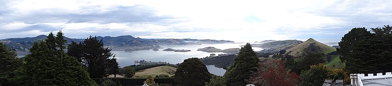
575:
284:
237:
The island has been known by a number of names, including St Martin Island. In 1996 as part of the
241:
233:. The remaining two storied Married Quarters building of the quarantine station is in the centre.
557:
542:
35:
197:, lies close to Quarantine Island. Both islands lie across the harbour between the town of
357:
273:
230:
210:
56:
504:"Search the List | Quarantine Island / Kamau Taurua Historic Area | Heritage New Zealand"
360:
was originally centred on
Quarantine Island (centre of image) and is now highly eroded.
597:
381:
198:
179:
77:
52:
503:
324:
238:
531:
Peat, N & Patrick, B (2002) Wild
Dunedin, University of Otago Press, Dunedin
261:
248:, meaning 'a place to set nets' was restored as part of the official name of
104:
91:
427:
194:
221:
183:
482:
458:"Quarantined: A sordid, sickly, sad underside of New Zealand history"
554:
Quarantine Island / Kamau Taurua (St Martin Island) A short history
265:
220:
581:
534:
Russell and McGeorge, P (2004) New
Zealand's Islands, Bateman.
584:
Quarantine Island / Kamau Taurua
Community (Inc) Information
428:"Place name detail: Quarantine Island/Kamau Taurua"
155:
147:
142:
128:
120:
83:
73:
68:
28:
8:
323:Interior of the chapel, with a view towards
23:
45:
22:
578:Te Ara - the Encyclopedia of New Zealand
404:. New Zealand Government. Archived from
16:Island in the Otago Harbour, New Zealand
537:Herd, J. & Griffiths, G.J. (1980).
393:
289:
556:St Martin Island Community, Dunedin.
7:
402:"List of place names to be amended"
377:List of historic places in Dunedin
311:Restored married couples' quarters
14:
225:Quarantine Island from above the
456:Weekes, John (9 February 2020).
345:
316:
304:
292:
176:Quarantine Island / Kamau Taurua
24:Quarantine Island / Kamau Taurua
588:The keeper of Quarantine Island
372:List of islands of New Zealand
250:Quarantine Island/Kamau Taurua
1:
590:RNZ interview, 6 October 2020
436:New Zealand Geographic Board
227:Portobello Marine Laboratory
178:), is the largest island in
174:and officially gazetted as
635:
338:Department of Conservation
188:Department of Conservation
260:The island served as the
160:
133:
64:
44:
105:45.828216°S 170.633104°E
280:were treated overseas.
244:settlement the name of
182:, close to the city of
51:Quarantine Island with
299:Exterior of the chapel
234:
156:Additional information
110:-45.828216; 170.633104
55:in the foreground and
432:New Zealand Gazetteer
224:
124:15 ha (37 acres)
604:Geography of Dunedin
285:Heritage New Zealand
207:Portobello Peninsula
539:Discovering Dunedin
508:www.heritage.org.nz
483:"Island of shame |"
101: /
25:
552:Hancock, L (2008)
408:on 7 December 2008
242:Treaty of Waitangi
235:
193:A smaller island,
576:Nearshore islands
562:978-0-473-14209-4
203:marine laboratory
168:Quarantine Island
165:
164:
59:in the background
626:
614:Islands of Otago
541:. John McIndoe.
519:
518:
516:
514:
500:
494:
493:
491:
489:
479:
473:
472:
470:
468:
453:
447:
446:
444:
442:
424:
418:
417:
415:
413:
398:
349:
320:
308:
296:
116:
115:
113:
112:
111:
106:
102:
99:
98:
97:
94:
49:
26:
634:
633:
629:
628:
627:
625:
624:
623:
594:
593:
572:
528:
523:
522:
512:
510:
502:
501:
497:
487:
485:
481:
480:
476:
466:
464:
455:
454:
450:
440:
438:
426:
425:
421:
411:
409:
400:
399:
395:
390:
368:
363:
362:
361:
358:Dunedin Volcano
355:
350:
334:
327:
321:
312:
309:
300:
297:
274:First World War
258:
231:Otago Peninsula
219:
211:Otago Peninsula
170:(also known as
138:
109:
107:
103:
100:
95:
92:
90:
88:
87:
60:
57:Otago Peninsula
40:
17:
12:
11:
5:
632:
630:
622:
621:
616:
611:
606:
596:
595:
592:
591:
585:
579:
571:
570:External links
568:
567:
566:
550:
535:
532:
527:
524:
521:
520:
495:
474:
448:
419:
392:
391:
389:
386:
385:
384:
379:
374:
367:
364:
352:
351:
344:
343:
342:
333:
330:
329:
328:
322:
315:
313:
310:
303:
301:
298:
291:
257:
254:
218:
215:
209:, part of the
163:
162:
158:
157:
153:
152:
149:
145:
144:
140:
139:
134:
131:
130:
129:Administration
126:
125:
122:
118:
117:
85:
81:
80:
75:
71:
70:
66:
65:
62:
61:
50:
42:
41:
29:
15:
13:
10:
9:
6:
4:
3:
2:
631:
620:
619:Otago Harbour
617:
615:
612:
610:
609:Port Chalmers
607:
605:
602:
601:
599:
589:
586:
583:
580:
577:
574:
573:
569:
565:
563:
559:
555:
551:
548:
547:0-86868-030-3
544:
540:
536:
533:
530:
529:
525:
509:
505:
499:
496:
484:
478:
475:
463:
459:
452:
449:
437:
433:
429:
423:
420:
407:
403:
397:
394:
387:
383:
382:Otago Harbour
380:
378:
375:
373:
370:
369:
365:
359:
354:
348:
341:
339:
331:
326:
319:
314:
307:
302:
295:
290:
288:
286:
281:
279:
275:
270:
267:
263:
255:
253:
251:
247:
243:
240:
232:
228:
223:
216:
214:
212:
208:
204:
200:
199:Port Chalmers
196:
191:
189:
185:
181:
180:Otago Harbour
177:
173:
169:
159:
154:
150:
146:
141:
137:
132:
127:
123:
119:
114:
86:
82:
79:
78:Otago Harbour
76:
72:
67:
63:
58:
54:
53:Port Chalmers
48:
43:
38:
37:
32:
27:
21:
19:
553:
538:
511:. Retrieved
507:
498:
488:18 September
486:. Retrieved
477:
465:. Retrieved
461:
451:
439:. Retrieved
431:
422:
410:. Retrieved
406:the original
396:
335:
325:Taiaroa Head
282:
271:
264:station for
259:
249:
246:Kamau Taurua
245:
236:
192:
175:
172:Kamau Taurua
171:
167:
166:
143:Demographics
135:
34:
31:Kamau Taurua
30:
20:
18:
513:29 November
467:16 February
272:During the
136:New Zealand
108: /
96:170°37′59″E
84:Coordinates
598:Categories
582:The Island
526:References
412:24 January
262:quarantine
148:Population
93:45°49′42″S
239:Ngāi Tahu
69:Geography
366:See also
332:Visitors
201:and the
195:Rakiriri
151:4 (2019)
74:Location
441:14 July
256:History
184:Dunedin
560:
545:
462:Stuff
388:Notes
266:Otago
217:Names
36:Māori
558:ISBN
543:ISBN
515:2018
490:2020
469:2020
443:2022
414:2009
356:The
121:Area
229:on
205:on
600::
506:.
460:.
434:.
430:.
278:VD
252:.
213:.
190:.
549:.
517:.
492:.
471:.
445:.
416:.
39:)
33:(
Text is available under the Creative Commons Attribution-ShareAlike License. Additional terms may apply.