207:
303:
only intended to be a temporary structure while the old bridge was removed and replaced. However, no construction or demolition works occurred until 10 years later, with the old bridge left for pedestrians. The third bridge was a renovation of the original bridge, which had its deck replaced, new support piles added, and existing piles modified. The previous bridge was demolished after this bridge, which also catered for trams, was opened in 1909. The current structure, which opened on 15 December 1939, was also only intended to be used for a few years, but has remained in service since then, with major strengthening and repair works carried out in 1978 and 1982.
39:
1015:
437:
151:
89:
409:
383:
138:
109:
312:
1791:
269:
343:
299:. There is no clear evidence of the construction date or usage, however there are accounts of it pulling a dredger and barges up the river, via a rope connected to a winch in the capstan. The accounts vary as to how it was powered, either by convicts or animals pushing an iron bar to rotate the capstan, which was centred on a vertical axle.
896:
302:
There have been four different bridges at this location since the 1860s, the first of which was a timber bridge was constructed between 1863 and 1867, using convict labour. The second bridge was constructed between 1896 and 1898 downstream of the existing bridge. Whilst wider and stronger, it was
276:
274:
271:
270:
275:
234:. The next major intersection, 350 metres (1,150 ft) south, is with Tydeman Road, which leads to Fremantle Port to the west, and to the residential area of North Fremantle to the east. After another 400 metres (1,300 ft), the road reaches the
273:
287:
In the 1830s ferries operated on the Swan River, including from North
Fremantle and from Preston Point, further up the river. The North Fremantle ferry only transported people and luggage, whilst the Preston Point ferry also transported livestock.
712:
246:, and turns south-west towards the centre of Fremantle. After travelling 500 metres (1,600 ft) south-west, State Route 12 leaves Queen Victoria Street, heading down James Street towards
958:
206:
272:
601:
578:
547:
326:
Two bars are also located on the north side of the river along Queen
Victoria Street: Mojo's Bar and the Swan Hotel, which has been on the street for over 100 years.
92:
640:
1585:
252:. The remaining 400 metres (1,300 ft) of Queen Victoria Street does not have a route allocation, and the road ends at its intersection with Parry Street.
1554:
1392:
1387:
1382:
1377:
1372:
1367:
1362:
1357:
1352:
1347:
1342:
1337:
1332:
1327:
1322:
1317:
1312:
1307:
1302:
1297:
1292:
1287:
1282:
1277:
1272:
1267:
1262:
1257:
1252:
1247:
1242:
1237:
1232:
1227:
1222:
1217:
1212:
1207:
1202:
1197:
1192:
1187:
1182:
1177:
1172:
1167:
1162:
1157:
1152:
1147:
1142:
1137:
1132:
1127:
1122:
1117:
1112:
1096:
1091:
1075:
1070:
1065:
987:
402:
215:
1852:
187:. The road was originally named Cantonment Road, but was subsequently renamed Victoria Road, and a few years later Queen Victoria Street, after
1543:
1538:
1533:
1528:
1523:
1518:
1513:
1508:
1503:
1498:
1493:
1488:
1483:
1478:
1473:
1468:
1463:
1458:
1453:
1448:
1443:
1438:
1433:
1428:
1423:
1418:
1413:
1408:
925:
742:
869:
1578:
449:
230:
117:
488:(2nd ed.). Nedlands, Western Australia: University of Western Australia Press for the Fremantle City Council. pp. 227–229.
416:
845:
674:
493:
453:
239:
50:
608:
1896:
1870:
1571:
424:
248:
1701:
980:
457:
1736:
1721:
1649:
1624:
463:
323:(1895–1961). The North Fremantle war memorial and the former North Fremantle Town Hall are located on the street.
253:
1822:
1741:
1716:
329:
In 2011, Queen
Victoria Street underwent road works to improve traffic accommodation and the amenity of the area.
1771:
1761:
1644:
430:
420:
315:
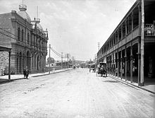
Victoria Avenue, North
Fremantle, later renamed Queen Victoria Street. North Fremantle Town Hall is on the left.
1776:
1756:
1664:
1659:
1654:
281:
235:
46:
38:
1766:
1674:
1875:
1807:
1751:
1746:
1726:
1711:
1706:
1679:
1669:
1639:
1634:
1629:
973:
320:
168:
1827:
1812:
1731:
1696:
257:
1842:
1034:
441:
1563:
770:
514:
395:
131:
645:
Register of
Heritage Places – Permanent Entry – Fremantle Traffic Bridge & Ferry Capstan Base
292:
1599:
1000:
949:
921:
489:
195:
29:
1857:
386:
225:
112:
356:
1817:
412:
243:
141:
220:
188:
1890:
1837:
1044:
1832:
1039:
996:
965:
445:
399:
82:
191:
of the United
Kingdom, to avoid confusion with similarly named roads in the area.
901:
1790:
311:
957:
840:
765:
737:
669:
509:
1799:
1608:
1595:
180:
573:
542:
817:
794:
350:
This article contains a bulleted list or table of intersections which
602:"Fremantle Railway Bridge to Point Walter Reserve and Childley Point"
390:
310:
267:
205:
184:
647:. Heritage Council of Western Australia. 30 March 2007. p. 5
1567:
969:
336:
746:. Perth. 8 September 1935. p. 1 Section: First Section
678:. Perth. 14 April 1927. p. 20 Supplement: Western Mail
352:
should be presented in a properly formatted junction table.
641:"Register of Heritage Places – Assessment Documentation"
635:
633:
631:
629:
280:
Driving from North
Fremantle to Fremantle, crossing the
945:
940:
360:
959:
Template:Attached KML/Queen
Victoria Street, Fremantle
718:. Engineers Australia Western Australia Division. 2009
664:
662:
440:
James Street (State Route 12 southeast) – via
1798:
1688:
1616:
1607:
1401:
1105:
1084:
1058:
295:, but only the base remains, which is known as the
164:
124:
103:
98:
81:
73:
65:
60:
23:
242:. On the south side of the river, the road meets
920:. Australia: Universal Publishers Pty Ltd. 2011.
579:The Perth Gazette and Western Australian Journal
548:The Perth Gazette and Western Australian Journal
256:continues south-west from that intersection, to
707:
705:
703:
701:
699:
697:
695:
693:
568:
566:
537:
535:
533:
1579:
981:
918:2011 UBD Perth and Surrounds Street Directory
359:for information on how to create one. Please
319:The street was the main street of the former
179:is the main road entering the city centre of
8:
466:(southwest) – to Fremantle city centre
838:A sailing club meeting at the hotel in 1901
486:The Western Gateway: A History of Fremantle
183:, Western Australia, from the direction of
1613:
1586:
1572:
1564:
1009:
988:
974:
966:
857:– via National Library of Australia.
782:– via National Library of Australia.
754:– via National Library of Australia.
686:– via National Library of Australia.
590:– via National Library of Australia.
559:– via National Library of Australia.
526:– via National Library of Australia.
210:Northern terminus of Queen Victoria Street
37:
20:
962:
462:Parry Street (northwest and southeast) /
1555:List of road routes in Western Australia
198:it has at times had very heavy traffic.
476:
819:Governor at North Fremantle Town Hall
214:The road's northern terminus, and of
7:
849:. Perth. 12 January 1901. p. 54
738:"Fremantle Traffic Bridge Should Go"
518:. Perth. 17 October 1923. p. 10
218:, are at a traffic light-controlled
16:Road in Fremantle, Western Australia
774:. Perth. 31 August 1933. p. 18
713:"Swan & Canning Rivers Bridges"
897:"Queen Victoria Street, Fremantle"
607:. Swan River Trust. Archived from
14:
870:"Queen Victoria Street roadworks"
796:North Fremantle soldiers memorial
1789:
1013:
582:. WA. 3 August 1833. p. 121
435:
407:
381:
341:
149:
136:
107:
87:
551:. WA. 27 June 1835. p. 517
1:
816:Orloff, Izzy; HRRC (1925),
793:Orloff, Izzy; HRRC (1924),
415:(State Route 6) – to
389:(State Route 5) – to
1913:
510:"FREMANTLE'S MAIN HIGHWAY"
1866:
1787:
1552:
1007:
872:. City of Fremantle. 2011
431:Fremantle railway station
77:2.0 km (1.2 mi)
56:
45:
36:
1695:Southwest to Northeast:
1623:Northwest to Southeast:
841:"Fremantle Sailing Club"
429:Beach Street – to
282:Fremantle Traffic Bridge
236:Fremantle Traffic Bridge
194:Due to its proximity to
47:Fremantle Traffic Bridge
484:Ewers, John K. (1971).
321:Town of North Fremantle
264:Crossing the Swan River
169:Parry Street, Fremantle
1876:Transport in Fremantle
316:
284:
211:
116:(State Route 5),
1848:Queen Victoria Street
1609:Fremantle city centre
1027:Queen Victoria Street
314:
291:There also existed a
279:
209:
177:Queen Victoria Street
156:(State Route 12)
25:Queen Victoria Street
1897:Streets in Fremantle
1871:Streets in Fremantle
963:KML is from Wikidata
766:"OLD TRAFFIC BRIDGE"
361:improve this article
145:(State Route 6)
118:North Fremantle
771:The West Australian
515:The West Australian
333:Major intersections
61:General information
1823:Carrington Street
317:
297:Ferry Capstan Base
285:
238:which crosses the
212:
1884:
1883:
1800:Greater Fremantle
1785:
1784:
1742:Holdsworth Street
1717:Cantonment Street
1702:Phillimore Street
1600:Western Australia
1561:
1560:
1059:National Highways
1053:
1052:
1001:Western Australia
927:978 0 7319 2653 4
889:Route description
403:Tourist Drive 204
378:
377:
277:
202:Route description
196:Fremantle Harbour
174:
173:
157:
146:
120:
30:Western Australia
1904:
1858:Stirling Highway
1793:
1762:Henderson Street
1737:Bannister Street
1614:
1588:
1581:
1574:
1565:
1017:
1016:
1010:
990:
983:
976:
967:
953:
931:
913:
911:
909:
882:
881:
879:
877:
866:
860:
858:
856:
854:
836:
830:
829:
828:
826:
813:
807:
806:
805:
803:
790:
784:
783:
781:
779:
762:
756:
755:
753:
751:
743:The Sunday Times
734:
728:
727:
725:
723:
717:
709:
688:
687:
685:
683:
666:
657:
656:
654:
652:
637:
624:
623:
621:
619:
613:
606:
598:
592:
591:
589:
587:
570:
561:
560:
558:
556:
539:
528:
527:
525:
523:
506:
500:
499:
481:
439:
438:
411:
410:
387:Stirling Highway
385:
384:
373:
370:
364:
345:
344:
337:
278:
251:
233:
226:Stirling Highway
223:
155:
153:
152:
144:
140:
139:
115:
113:Stirling Highway
111:
110:
91:
90:
41:
21:
1912:
1911:
1907:
1906:
1905:
1903:
1902:
1901:
1887:
1886:
1885:
1880:
1862:
1818:Canning Highway
1794:
1781:
1722:Adelaide Street
1684:
1650:Pakenham Street
1603:
1592:
1562:
1557:
1548:
1397:
1101:
1085:National Routes
1080:
1054:
1049:
1014:
1003:
994:
964:
961:
956:
955:
954:
938:
934:
928:
916:
907:
905:
895:
886:
885:
875:
873:
868:
867:
863:
852:
850:
839:
837:
833:
824:
822:
815:
814:
810:
801:
799:
792:
791:
787:
777:
775:
764:
763:
759:
749:
747:
736:
735:
731:
721:
719:
715:
711:
710:
691:
681:
679:
668:
667:
660:
650:
648:
639:
638:
627:
617:
615:
611:
604:
600:
599:
595:
585:
583:
574:"FERRY CHARGES"
572:
571:
564:
554:
552:
541:
540:
531:
521:
519:
508:
507:
503:
496:
483:
482:
478:
473:
464:Adelaide Street
450:South Fremantle
436:
413:Canning Highway
408:
382:
374:
368:
365:
355:Please consult
354:
346:
342:
335:
309:
307:Street features
268:
266:
254:Adelaide Street
247:
244:Canning Highway
231:North Fremantle
229:
219:
204:
160:
150:
142:Canning Highway
137:
108:
99:Major junctions
88:
83:Route number(s)
32:
27:
26:
17:
12:
11:
5:
1910:
1908:
1900:
1899:
1889:
1888:
1882:
1881:
1879:
1878:
1873:
1867:
1864:
1863:
1861:
1860:
1855:
1850:
1845:
1840:
1835:
1830:
1825:
1820:
1815:
1810:
1804:
1802:
1796:
1795:
1788:
1786:
1783:
1782:
1780:
1779:
1777:Suffolk Street
1774:
1772:Norfolk Street
1769:
1764:
1759:
1754:
1749:
1744:
1739:
1734:
1729:
1724:
1719:
1714:
1709:
1704:
1699:
1692:
1690:
1686:
1685:
1683:
1682:
1677:
1672:
1667:
1665:William Street
1662:
1657:
1652:
1647:
1645:Marine Terrace
1642:
1637:
1632:
1627:
1620:
1618:
1611:
1605:
1604:
1593:
1591:
1590:
1583:
1576:
1568:
1559:
1558:
1553:
1550:
1549:
1547:
1546:
1541:
1536:
1531:
1526:
1521:
1516:
1511:
1506:
1501:
1496:
1491:
1486:
1481:
1476:
1471:
1466:
1461:
1456:
1451:
1446:
1441:
1436:
1431:
1426:
1421:
1416:
1411:
1405:
1403:
1402:Tourist Drives
1399:
1398:
1396:
1395:
1390:
1385:
1380:
1375:
1370:
1365:
1360:
1355:
1350:
1345:
1340:
1335:
1330:
1325:
1320:
1315:
1310:
1305:
1300:
1295:
1290:
1285:
1280:
1275:
1270:
1265:
1260:
1255:
1250:
1245:
1240:
1235:
1230:
1225:
1220:
1215:
1210:
1205:
1200:
1195:
1190:
1185:
1180:
1175:
1170:
1165:
1160:
1155:
1150:
1145:
1140:
1135:
1130:
1125:
1120:
1115:
1109:
1107:
1103:
1102:
1100:
1099:
1094:
1088:
1086:
1082:
1081:
1079:
1078:
1073:
1068:
1062:
1060:
1056:
1055:
1051:
1050:
1048:
1047:
1042:
1037:
1032:
1029:
1023:
1020:
1019:
1018:State Route 12
1008:
1005:
1004:
995:
993:
992:
985:
978:
970:
937:
936:
935:
933:
932:
926:
914:
892:
891:
890:
884:
883:
861:
831:
808:
785:
757:
729:
689:
658:
625:
614:on 12 May 2013
593:
562:
543:"PROCLAMATION"
529:
501:
494:
475:
474:
472:
469:
468:
467:
460:
433:
427:
417:East Fremantle
405:
393:
376:
375:
357:this guideline
349:
347:
340:
334:
331:
308:
305:
265:
262:
216:State Route 12
203:
200:
189:Queen Victoria
172:
171:
166:
162:
161:
159:
158:
147:
134:
128:
126:
122:
121:
105:
101:
100:
96:
95:
93:State Route 12
85:
79:
78:
75:
71:
70:
67:
63:
62:
58:
57:
54:
53:
43:
42:
34:
33:
28:
24:
15:
13:
10:
9:
6:
4:
3:
2:
1909:
1898:
1895:
1894:
1892:
1877:
1874:
1872:
1869:
1868:
1865:
1859:
1856:
1854:
1851:
1849:
1846:
1844:
1841:
1839:
1838:Leach Highway
1836:
1834:
1831:
1829:
1826:
1824:
1821:
1819:
1816:
1814:
1811:
1809:
1806:
1805:
1803:
1801:
1797:
1792:
1778:
1775:
1773:
1770:
1768:
1765:
1763:
1760:
1758:
1757:Collie Street
1755:
1753:
1750:
1748:
1745:
1743:
1740:
1738:
1735:
1733:
1730:
1728:
1725:
1723:
1720:
1718:
1715:
1713:
1710:
1708:
1705:
1703:
1700:
1698:
1694:
1693:
1691:
1687:
1681:
1678:
1676:
1673:
1671:
1668:
1666:
1663:
1661:
1660:South Terrace
1658:
1656:
1655:Market Street
1653:
1651:
1648:
1646:
1643:
1641:
1638:
1636:
1633:
1631:
1628:
1626:
1622:
1621:
1619:
1615:
1612:
1610:
1606:
1601:
1597:
1589:
1584:
1582:
1577:
1575:
1570:
1569:
1566:
1556:
1551:
1545:
1542:
1540:
1537:
1535:
1532:
1530:
1527:
1525:
1522:
1520:
1517:
1515:
1512:
1510:
1507:
1505:
1502:
1500:
1497:
1495:
1492:
1490:
1487:
1485:
1482:
1480:
1477:
1475:
1472:
1470:
1467:
1465:
1462:
1460:
1457:
1455:
1452:
1450:
1447:
1445:
1442:
1440:
1437:
1435:
1432:
1430:
1427:
1425:
1422:
1420:
1417:
1415:
1412:
1410:
1407:
1406:
1404:
1400:
1394:
1391:
1389:
1386:
1384:
1381:
1379:
1376:
1374:
1371:
1369:
1366:
1364:
1361:
1359:
1356:
1354:
1351:
1349:
1346:
1344:
1341:
1339:
1336:
1334:
1331:
1329:
1326:
1324:
1321:
1319:
1316:
1314:
1311:
1309:
1306:
1304:
1301:
1299:
1296:
1294:
1291:
1289:
1286:
1284:
1281:
1279:
1276:
1274:
1271:
1269:
1266:
1264:
1261:
1259:
1256:
1254:
1251:
1249:
1246:
1244:
1241:
1239:
1236:
1234:
1231:
1229:
1226:
1224:
1221:
1219:
1216:
1214:
1211:
1209:
1206:
1204:
1201:
1199:
1196:
1194:
1191:
1189:
1186:
1184:
1181:
1179:
1176:
1174:
1171:
1169:
1166:
1164:
1161:
1159:
1156:
1154:
1151:
1149:
1146:
1144:
1141:
1139:
1136:
1134:
1131:
1129:
1126:
1124:
1121:
1119:
1116:
1114:
1111:
1110:
1108:
1104:
1098:
1095:
1093:
1090:
1089:
1087:
1083:
1077:
1074:
1072:
1069:
1067:
1064:
1063:
1061:
1057:
1046:
1045:Cockburn Road
1043:
1041:
1038:
1036:
1033:
1030:
1028:
1025:
1024:
1022:
1021:
1012:
1011:
1006:
1002:
998:
991:
986:
984:
979:
977:
972:
971:
968:
960:
951:
947:
943:
942:
929:
923:
919:
915:
904:
903:
898:
894:
893:
888:
887:
871:
865:
862:
848:
847:
842:
835:
832:
821:
820:
812:
809:
798:
797:
789:
786:
773:
772:
767:
761:
758:
745:
744:
739:
733:
730:
714:
708:
706:
704:
702:
700:
698:
696:
694:
690:
677:
676:
671:
665:
663:
659:
646:
642:
636:
634:
632:
630:
626:
610:
603:
597:
594:
581:
580:
575:
569:
567:
563:
550:
549:
544:
538:
536:
534:
530:
517:
516:
511:
505:
502:
497:
491:
487:
480:
477:
470:
465:
461:
459:
455:
454:Hamilton Hill
451:
447:
443:
434:
432:
428:
426:
422:
418:
414:
406:
404:
401:
397:
394:
392:
388:
380:
379:
372:
369:December 2021
362:
358:
353:
348:
339:
338:
332:
330:
327:
324:
322:
313:
306:
304:
300:
298:
294:
289:
283:
263:
261:
259:
255:
250:
245:
241:
237:
232:
227:
222:
217:
208:
201:
199:
197:
192:
190:
186:
182:
178:
170:
167:
163:
154:James Street
148:
143:
135:
133:
130:
129:
127:
123:
119:
114:
106:
102:
97:
94:
86:
84:
80:
76:
72:
68:
64:
59:
55:
52:
49:crossing the
48:
44:
40:
35:
31:
22:
19:
1853:South Street
1847:
1833:Hampton Road
1808:Beach Street
1767:Essex Street
1752:Nairn Street
1747:Croke Street
1727:Ellen Street
1712:Leake Street
1707:Short Street
1689:Longitudinal
1680:Parry Street
1675:Point Street
1670:Queen Street
1640:Henry Street
1635:Mouat Street
1630:Cliff Street
1106:State Routes
1040:Hampton Road
1031:James Street
1026:
939:
917:
906:. Retrieved
900:
874:. Retrieved
864:
851:. Retrieved
846:Western Mail
844:
834:
823:, retrieved
818:
811:
800:, retrieved
795:
788:
776:. Retrieved
769:
760:
748:. Retrieved
741:
732:
720:. Retrieved
680:. Retrieved
675:Western Mail
673:
649:. Retrieved
644:
616:. Retrieved
609:the original
596:
584:. Retrieved
577:
553:. Retrieved
546:
520:. Retrieved
513:
504:
495:085564 050 2
485:
479:
446:Hampton Road
400:Sunset Coast
396:Tydeman Road
366:
351:
328:
325:
318:
301:
296:
290:
286:
213:
193:
176:
175:
132:Tydeman Road
18:
1828:East Street
1813:Burt Street
1732:High Street
1697:Elder Place
1625:Little High
1617:Latitudinal
1602:, Australia
1594:Streets of
997:Road routes
902:Google Maps
682:11 November
651:10 November
398:– to
363:if you can.
258:High Street
1843:Ord Street
1035:Ord Street
908:6 November
876:7 November
853:8 November
825:7 November
802:7 November
778:8 November
750:7 November
722:7 November
670:"Untitled"
618:8 November
586:8 November
555:8 November
522:7 November
471:References
442:Ord Street
425:Applecross
249:Naval Base
240:Swan River
221:Y Junction
51:Swan River
1596:Fremantle
458:Spearwood
181:Fremantle
165:South end
104:North end
1891:Category
941:KML file
899:(Map).
293:capstan
1208:Alt 30
1097:Alt 94
924:
492:
421:Bicton
125:
74:Length
716:(PDF)
612:(PDF)
605:(PDF)
391:Perth
224:with
185:Perth
950:help
946:edit
922:ISBN
910:2012
878:2012
855:2012
827:2012
804:2012
780:2012
752:2012
724:2012
684:2012
653:2012
620:2012
588:2012
557:2012
524:2012
490:ISBN
456:and
444:and
423:and
69:Road
66:Type
1544:360
1539:359
1534:358
1529:357
1524:356
1519:355
1514:354
1509:353
1504:352
1499:351
1494:350
1489:259
1484:258
1479:257
1474:256
1469:255
1464:254
1459:252
1454:251
1449:250
1444:207
1439:206
1434:205
1429:204
1424:203
1419:202
1414:201
1409:200
1393:139
1388:138
1383:136
1378:123
1373:120
1368:116
1363:115
1358:107
1353:104
1348:102
999:in
448:to
228:in
1893::
1598:,
1343:87
1338:85
1333:84
1328:83
1323:82
1318:81
1313:78
1308:77
1303:76
1298:75
1293:72
1288:71
1283:66
1278:65
1273:64
1268:61
1263:60
1258:56
1253:55
1248:53
1243:52
1238:51
1233:50
1228:41
1223:40
1218:36
1213:31
1203:30
1198:27
1193:26
1188:22
1183:21
1178:20
1173:19
1168:18
1163:14
1158:13
1153:12
1148:10
1076:95
1071:94
948:•
843:.
768:.
740:.
692:^
672:.
661:^
643:.
628:^
576:.
565:^
545:.
532:^
512:.
452:,
419:,
260:.
1587:e
1580:t
1573:v
1143:8
1138:7
1133:6
1128:5
1123:4
1118:3
1113:2
1092:1
1066:1
989:e
982:t
975:v
952:)
944:(
930:.
912:.
880:.
859:.
726:.
655:.
622:.
498:.
371:)
367:(
Text is available under the Creative Commons Attribution-ShareAlike License. Additional terms may apply.