56:
40:
63:
379:
303:
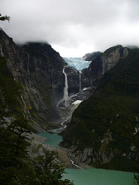
Cascada de
Ventisquero Colgante, a large waterfall, is located in the park. As the meltwaters of the eponymous glacier proceed into the Témpanos River, they fall down the waterfall's single vertical drop.
230:, with glaciers of up to 12 km (7 mi) long. The largest glaciated area is Queulat ice cap, which encompasses about 80 km (31 sq mi) and contains the park's centerpiece, the
184:
79:
265:, and is at an elevation of 1,889 m (6,198 ft). The other ice cap covers an area of approximately 40 km (15 sq mi) and is centered at an unnamed summit at
673:
638:
904:
894:
813:
323:. Various portions of the park receive up to 4,000 mm (157 in) of precipitation annually. In this wet environment typical trees include
853:
753:
631:
55:
909:
105:
678:
683:
658:
583:
899:
788:
624:
320:
164:
828:
808:
748:
708:
647:
848:
838:
763:
192:
25:
863:
803:
743:
728:
693:
688:
668:
268:
237:
532:
723:
663:
713:
703:
778:
768:
223:
889:
733:
472:
858:
783:
738:
718:
416:
328:
793:
868:
798:
698:
195:. It contains 1,541 km (595 sq mi) of glacier-capped mountains and virgin evergreen forests.
843:
833:
773:
307:
Other attractions in the park are the
Queulat Sound, Father García and The Cóndor Falls, and Cat's Stone (
423:. The northern sections of the park are home to nearshore wildlife including semi-aquatic mammals as are
296:, at an elevation of 2,255 m (7,398 ft). The main ice cap borders the northernmost part of the
818:
440:
420:
412:
352:
226:
form part of the park, specifically the area south of the Lake
Risopatrón. The park comprises two small
424:
372:
231:
758:
452:
448:
344:
222:, with some elevations greater than 2,000 m (6,562 ft) above sea level. A portion of the
204:
356:
488:
460:
456:
360:
297:
556:
93:
484:
404:
509:
611:
432:
408:
340:
883:
436:
392:
176:
29:
476:
444:
364:
351:(a plant with enormous leaves). At higher elevations, the forests are dominated by
188:
39:
203:
In 1766, the Jesuit Father José García Alsue explored the area searching for the
468:
464:
378:
480:
332:
283:
270:
252:
239:
120:
107:
510:"P 1386-I Chile and Argentina - Wet Andes: Tinguiririca Pass - Puerto Aisen"
227:
216:
616:
396:
336:
400:
324:
533:"Ventisquero Colgante, Cascada de, Chile - World Waterfall Database"
428:
377:
348:
219:
180:
83:
620:
363:
runs through the middle of the park and includes a stretch of
319:
A characteristic feature of this park is the presence of
160:
152:
144:
136:
99:
89:
75:
18:
185:Aysén del General Carlos Ibáñez del Campo Region
80:Aysén del General Carlos Ibáñez del Campo Region
557:"Ventisquero Colgante de Queulat - Wikiexplora"
632:
391:In the southern portion of the park (Queulat
62:
8:
403:, and a variety of birds species including
639:
625:
617:
15:
500:
382:Cuesta Queulat - Queulat National Park.
335:vegetation consists of species such as
578:
576:
395:), wildlife includes mammals such as
191:on the south side and is neighbor to
7:
527:
525:
74:
905:Protected areas established in 1983
431:. Birds found in this area include
140:1,541 km (595 sq mi)
14:
215:Local relief is dominated by the
321:Valdivian temperate rain forests
61:
54:
38:
895:Protected areas of Aysén Region
371:), along which can be observed
143:
88:
674:Archipiélago de Juan Fernández
612:CONAF: Parque Nacional Queulat
537:www.worldwaterfalldatabase.com
234:. This ice cap is centered at
193:Lago Rosselot National Reserve
187:. The park is bordered by the
1:
165:Corporación Nacional Forestal
910:Valdivian temperate forests
375:of vegetation in the park.
926:
300:called Ventisquero Sound.
654:
473:black-crowned night heron
49:
37:
23:
814:Pumalín Douglas Tompkins
417:black-throated huet-huet
224:Puyuhuapi Volcanic Group
156:6,195 (in 2004)
900:National parks of Chile
648:National parks of Chile
232:Queulat Hanging Glacier
383:
854:Vicente Pérez Rosales
754:Las Palmas de Cocalán
588:Queulat National Park
441:yellow-billed pintail
421:thorn-tailed rayadito
413:Magellanic woodpecker
381:
173:Queulat National Park
121:44.41667°S 72.36667°W
19:Queulat National Park
684:Bosque de Fray Jorge
425:southern river otter
353:coigüe de Magallanes
126:-44.41667; -72.36667
659:Alberto de Agostini
561:www.wikiexplora.com
453:rosy-billed pochard
449:flying steamer duck
280: /
249: /
205:City of the Caesars
161:Governing body
117: /
789:Nevado Tres Cruces
679:Bernardo O'Higgins
590:. Explora Magazine
384:
877:
876:
829:Radal Siete Tazas
764:Llanos de Challes
749:Laguna San Rafael
489:black-necked swan
461:ringed kingfisher
457:red-gartered coot
373:altitudinal zones
361:Carretera Austral
298:Puyuhuapi Channel
284:44.500°S 72.317°W
253:44.417°S 72.417°W
170:
169:
90:Nearest city
917:
890:IUCN Category II
849:Torres del Paine
839:Salar del Huasco
641:
634:
627:
618:
599:
598:
596:
595:
580:
571:
570:
568:
567:
553:
547:
546:
544:
543:
529:
520:
519:
517:
516:
505:
295:
294:
292:
291:
290:
289:-44.500; -72.317
285:
281:
278:
277:
276:
273:
264:
263:
261:
260:
259:
258:-44.417; -72.417
254:
250:
247:
246:
245:
242:
132:
131:
129:
128:
127:
122:
118:
115:
114:
113:
110:
94:Puerto Puyuhuapi
65:
64:
58:
42:
16:
925:
924:
920:
919:
918:
916:
915:
914:
880:
879:
878:
873:
744:Laguna del Laja
650:
645:
608:
603:
602:
593:
591:
582:
581:
574:
565:
563:
555:
554:
550:
541:
539:
531:
530:
523:
514:
512:
507:
506:
502:
497:
485:Chilean flicker
405:chucao tapaculo
389:
317:
309:Piedra del Gato
288:
286:
282:
279:
274:
271:
269:
267:
266:
257:
255:
251:
248:
243:
240:
238:
236:
235:
213:
201:
183:located in the
125:
123:
119:
116:
111:
108:
106:
104:
103:
71:
70:
69:
68:
67:
66:
45:
44:Queulat Glacier
33:
12:
11:
5:
923:
921:
913:
912:
907:
902:
897:
892:
882:
881:
875:
874:
872:
871:
866:
861:
856:
851:
846:
841:
836:
831:
826:
821:
816:
811:
806:
801:
796:
791:
786:
781:
776:
771:
766:
761:
756:
751:
746:
741:
736:
731:
729:Isla Magdalena
726:
721:
716:
711:
706:
701:
696:
694:Cerro Castillo
691:
689:Cabo de Hornos
686:
681:
676:
671:
669:Alerce Costero
666:
661:
655:
652:
651:
646:
644:
643:
636:
629:
621:
615:
614:
607:
606:External links
604:
601:
600:
572:
548:
521:
499:
498:
496:
493:
433:Magellan goose
409:Chilean pigeon
388:
385:
369:Cuesta Queulat
316:
313:
212:
211:Park geography
209:
200:
197:
168:
167:
162:
158:
157:
154:
150:
149:
146:
142:
141:
138:
134:
133:
101:
97:
96:
91:
87:
86:
77:
73:
72:
60:
59:
53:
52:
51:
50:
47:
46:
43:
35:
34:
24:
21:
20:
13:
10:
9:
6:
4:
3:
2:
922:
911:
908:
906:
903:
901:
898:
896:
893:
891:
888:
887:
885:
870:
867:
865:
864:Volcán Isluga
862:
860:
857:
855:
852:
850:
847:
845:
842:
840:
837:
835:
832:
830:
827:
825:
822:
820:
817:
815:
812:
810:
807:
805:
804:Pan de Azúcar
802:
800:
797:
795:
792:
790:
787:
785:
782:
780:
777:
775:
772:
770:
767:
765:
762:
760:
757:
755:
752:
750:
747:
745:
742:
740:
737:
735:
732:
730:
727:
725:
724:Isla Guamblin
722:
720:
717:
715:
712:
710:
707:
705:
702:
700:
697:
695:
692:
690:
687:
685:
682:
680:
677:
675:
672:
670:
667:
665:
664:Alerce Andino
662:
660:
657:
656:
653:
649:
642:
637:
635:
630:
628:
623:
622:
619:
613:
610:
609:
605:
589:
585:
579:
577:
573:
562:
558:
552:
549:
538:
534:
528:
526:
522:
511:
504:
501:
494:
492:
490:
486:
482:
478:
474:
470:
466:
462:
458:
454:
450:
446:
442:
438:
437:Chiloe wigeon
434:
430:
426:
422:
418:
414:
410:
406:
402:
398:
394:
393:mountain pass
386:
380:
376:
374:
370:
366:
365:hairpin turns
362:
358:
354:
350:
346:
342:
338:
334:
330:
326:
322:
314:
312:
310:
305:
301:
299:
293:
262:
233:
229:
225:
221:
218:
210:
208:
206:
198:
196:
194:
190:
186:
182:
178:
177:national park
174:
166:
163:
159:
155:
151:
147:
139:
135:
130:
102:
98:
95:
92:
85:
81:
78:
57:
48:
41:
36:
31:
30:national park
27:
26:IUCN category
22:
17:
823:
779:Morro Moreno
769:Llullaillaco
592:. Retrieved
587:
564:. Retrieved
560:
551:
540:. Retrieved
536:
513:. Retrieved
503:
477:torrent duck
445:red shoveler
390:
368:
318:
308:
306:
302:
214:
202:
189:Cisnes River
172:
171:
469:cocoi heron
465:great egret
287: /
256: /
145:Established
124: /
100:Coordinates
884:Categories
859:Villarrica
784:Nahuelbuta
739:La Campana
719:Huerquehue
714:Hornopirén
704:Conguillío
594:2006-10-30
584:"On Green"
566:2021-01-01
542:2021-01-01
515:2006-10-31
495:References
481:sedge wren
333:understory
228:ice fields
217:Patagonian
869:Yendegaia
809:Patagonia
799:Pali Aike
709:Corcovado
112:72°22′0″W
109:44°25′0″S
844:Tolhuaca
834:Rapa Nui
774:Melimoyu
734:Kawésqar
153:Visitors
76:Location
824:Queulat
819:Puyehue
794:Nonguén
275:72°19′W
272:44°30′S
244:72°25′W
241:44°25′S
199:History
699:Chiloé
508:USGS.
401:kodkod
359:. The
345:chilco
331:. The
325:coihue
759:Lauca
429:coypu
387:Fauna
357:lenga
349:nalca
341:quila
315:Flora
220:Andes
181:Chile
175:is a
84:Chile
487:and
427:and
419:and
397:pudú
355:and
347:and
337:tepú
329:tepa
327:and
148:1983
137:Area
28:II (
311:).
179:of
886::
586:.
575:^
559:.
535:.
524:^
491:.
483:,
479:,
475:,
471:,
467:,
463:,
459:,
455:,
451:,
447:,
443:,
439:,
435:,
415:,
411:,
407:,
399:,
343:,
339:,
207:.
82:,
640:e
633:t
626:v
597:.
569:.
545:.
518:.
367:(
32:)
Text is available under the Creative Commons Attribution-ShareAlike License. Additional terms may apply.