52:
72:
89:
990:
125:
161:
236:
256:
168:
132:
96:
662:
598:
Of the 215 households, 36.3% had children under the age of 18; 54.0% were married couples living together; 14.4% had a female householder with no husband present and 24.2% were non-families. Of all households, 18.6% were made up of individuals and 7.0% had someone living alone who was 65 years of age
602:
28.7% of the population were under the age of 18, 5.6% from 18 to 24, 26.5% from 25 to 44, 24.8% from 45 to 64, and 14.3% who were 65 years of age or older. The median age was 37.1 years. For every 100 females, the population had 100.0 males. For every 100 females ages 18 and older there were 94.0
51:
1265:
71:
482:, Quinton CDP had a total area of 0.908 square miles (2.354 km), including 0.885 square miles (2.293 km) of land and 0.023 square miles (0.061 km) of water (2.57%).
928:
88:
798:
GCT-PH1 - Population, Housing Units, Area, and
Density: 2010 - County -- County Subdivision and Place from the 2010 Census Summary File 1 for Salem County, New Jersey
1270:
588:
567:
was 664.1 per square mile (256.4/km). There were 225 housing units at an average density of 254.1 per square mile (98.1/km). The racial makeup was 86.05% (506)
800:
196:
1052:
412:
124:
160:
470:
Quinton CDP and
Quinton Township are not coextensive, with the CDP covering 3.7% of the 24.588 miles (39.571 km) of the township as a whole.
921:
1275:
1087:
718:
1172:
687:
424:
1042:
914:
1120:
1115:
1077:
1072:
1067:
1057:
766:
280:
1150:
1047:
584:
440:
268:
906:
878:
DP-1 - Profile of
General Population and Housing Characteristics: 2010 Demographic Profile Data for Quinton CDP, New Jersey
778:
645:
576:
1135:
1082:
1062:
1037:
722:
448:
285:
20:
797:
897:
881:
840:
824:
808:
782:
738:
706:
649:
630:
479:
877:
626:
1235:
1105:
560:
531:
516:
464:
1202:
1167:
938:
452:
400:
273:
228:
109:
57:
683:
1207:
1130:
1097:
1014:
820:
444:
42:
1192:
1177:
592:
1222:
1197:
1187:
1029:
1019:
837:
New Jersey: 2010 - Population and
Housing Unit Counts - 2010 Census of Population and Housing (CPH-2-32)
380:
1242:
1182:
1001:
369:
580:
572:
568:
1217:
1162:
1125:
1110:
564:
1212:
1009:
979:
971:
960:
359:
750:
417:
684:
U.S. Geological Survey
Geographic Names Information System: Quinton Census Designated Place
376:
355:
1259:
804:
702:
405:
241:
599:
or older. The average household size was 2.73 and the average family size was 3.12.
836:
852:
779:
State of New Jersey Census
Designated Places - BVP20 - Data as of January 1, 2020
953:
893:
856:
460:
456:
261:
248:
145:
61:
211:
198:
350:
388:
563:
counted 588 people, 215 households, and 163 families in the CDP. The
989:
60:
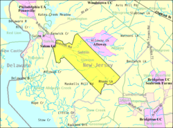
highlighted in red (left). Inset map: Location of Salem County in
910:
988:
821:
2006-2010 American
Community Survey Geography for New Jersey
762:
734:
753:, Missouri Census Data Center. Accessed June 9, 2023.
1266:
Census-designated places in Salem County, New Jersey
28:
Census-designated place in New Jersey, United States
1149:
1096:
1028:
1000:
970:
423:
411:
399:
387:
366:
349:
341:
333:
328:
320:
312:
304:
296:
291:
279:
267:
247:
227:
33:
76:Census Bureau map of Quinton Township, New Jersey
595:of any race were 3.06% (18) of the population.
316:0.02 sq mi (0.06 km) 2.57%
16:Populated place in Salem County, New Jersey, US
922:
873:
871:
869:
867:
865:
703:Census Data Explorer: Quinton CDP, New Jersey
8:
698:
696:
622:
620:
618:
616:
993:Map of New Jersey highlighting Salem County
929:
915:
907:
843:, August 2012. Accessed February 10, 2013.
489:
30:
793:
791:
591:, and 5.44% (32) from two or more races.
646:US Gazetteer files: 2010, 2000, and 1990
612:
410:
386:
348:
327:
319:
290:
226:
191:
80:
48:
1271:Census-designated places in New Jersey
751:Geographic Codes Lookup for New Jersey
509:
641:
639:
422:
398:
365:
340:
332:
311:
303:
295:
278:
266:
246:
68:
7:
114:Show map of Salem County, New Jersey
688:Geographic Names Information System
308:0.89 sq mi (2.29 km)
300:0.91 sq mi (2.35 km)
167:
131:
95:
937:Municipalities and communities of
719:Look Up a ZIP Code for Quinton, NJ
499:
467:, the CDP's population was 1,402.
14:
894:Census of Population and Housing
663:"ArcGIS REST Services Directory"
254:
234:
166:
159:
130:
123:
94:
87:
70:
56:Location of Quinton Township in
50:
767:United States Geological Survey
627:Gazetteer of New Jersey Places
1:
884:. Accessed February 10, 2013.
827:. Accessed February 10, 2013.
811:. Accessed February 10, 2013.
769:. Accessed September 4, 2014.
741:. Accessed September 4, 2014.
725:. Accessed February 10, 2013.
690:. Accessed February 10, 2013.
665:. United States Census Bureau
652:. Accessed September 4, 2014.
345:531.07/sq mi (204.95/km)
183:Show map of the United States
180:Location in the United States
1276:Quinton Township, New Jersey
785:. Accessed December 1, 2022.
763:US Board on Geographic Names
723:United States Postal Service
21:Quinton Township, New Jersey
898:United States Census Bureau
882:United States Census Bureau
841:United States Census Bureau
825:United States Census Bureau
809:United States Census Bureau
783:United States Census Bureau
739:United States Census Bureau
707:United States Census Bureau
650:United States Census Bureau
631:United States Census Bureau
480:United States Census Bureau
64:highlighted in red (right).
1292:
859:. Accessed April 19, 2015.
18:
1231:
986:
951:
709:. Accessed June 15, 2023.
633:. Accessed July 21, 2016.
573:Black or African American
561:2010 United States census
545:
530:
515:
508:
503:
498:
495:
465:2010 United States Census
192:
81:
69:
49:
40:
940:Salem County, New Jersey
900:. Accessed June 1, 2023.
441:unincorporated community
445:census-designated place
212:39.547478°N 75.410915°W
43:Census-designated place
994:
150:Show map of New Jersey
19:For the township, see
992:
546:U.S. Decennial Census
491:Historical population
447:(CDP) located within
368: • Summer (
324:23 ft (7 m)
217:39.547478; -75.410915
1244:United States portal
1053:Lower Alloways Creek
342: • Density
735:U.S. Census website
492:
208: /
35:Quinton, New Jersey
995:
593:Hispanic or Latino
565:population density
490:
334: • Total
313: • Water
297: • Total
1253:
1252:
1237:New Jersey portal
587:, 0.34% (2) from
552:
551:
478:According to the
434:
433:
305: • Land
1283:
1245:
1238:
1088:Upper Pittsgrove
991:
963:
956:
946:
941:
931:
924:
917:
908:
901:
891:
885:
875:
860:
850:
844:
834:
828:
818:
812:
795:
786:
776:
770:
760:
754:
748:
742:
732:
726:
716:
710:
700:
691:
681:
675:
674:
672:
670:
659:
653:
643:
634:
624:
585:Pacific Islander
511:
506:
501:
493:
449:Quinton Township
373:
260:
258:
257:
240:
238:
237:
223:
222:
220:
219:
218:
213:
209:
206:
205:
204:
201:
184:
170:
169:
163:
151:
134:
133:
127:
115:
98:
97:
91:
74:
54:
31:
1291:
1290:
1286:
1285:
1284:
1282:
1281:
1280:
1256:
1255:
1254:
1249:
1243:
1236:
1227:
1154:
1152:
1145:
1121:Hancocks Bridge
1092:
1024:
996:
984:
966:
961:
954:
947:
944:
939:
935:
905:
904:
892:
888:
876:
863:
853:Locality Search
851:
847:
835:
831:
819:
815:
796:
789:
777:
773:
761:
757:
749:
745:
733:
729:
717:
713:
701:
694:
682:
678:
668:
666:
661:
660:
656:
644:
637:
625:
614:
609:
577:Native American
557:
547:
504:
488:
476:
395:
367:
255:
253:
235:
233:
216:
214:
210:
207:
202:
199:
197:
195:
194:
188:
187:
186:
185:
182:
181:
178:
177:
176:
175:
171:
154:
153:
152:
149:
148:
142:
141:
140:
139:
135:
118:
117:
116:
113:
112:
106:
105:
104:
103:
99:
77:
65:
45:
36:
29:
24:
17:
12:
11:
5:
1289:
1287:
1279:
1278:
1273:
1268:
1258:
1257:
1251:
1250:
1248:
1247:
1240:
1232:
1229:
1228:
1226:
1225:
1220:
1215:
1210:
1205:
1200:
1195:
1190:
1185:
1180:
1175:
1170:
1165:
1159:
1157:
1153:unincorporated
1147:
1146:
1144:
1143:
1138:
1133:
1128:
1123:
1118:
1113:
1108:
1102:
1100:
1094:
1093:
1091:
1090:
1085:
1080:
1075:
1070:
1065:
1060:
1055:
1050:
1045:
1040:
1034:
1032:
1026:
1025:
1023:
1022:
1017:
1012:
1006:
1004:
998:
997:
987:
985:
983:
982:
976:
974:
968:
967:
952:
949:
948:
936:
934:
933:
926:
919:
911:
903:
902:
886:
861:
845:
829:
813:
803:2020-02-12 at
787:
771:
755:
743:
727:
711:
692:
676:
654:
635:
611:
610:
608:
605:
556:
553:
550:
549:
543:
542:
539:
537:
534:
528:
527:
524:
522:
519:
513:
512:
507:
502:
497:
487:
484:
475:
472:
432:
431:
428:
421:
420:
415:
409:
408:
403:
397:
396:
393:
391:
385:
384:
374:
364:
363:
353:
347:
346:
343:
339:
338:
335:
331:
330:
326:
325:
322:
318:
317:
314:
310:
309:
306:
302:
301:
298:
294:
293:
289:
288:
283:
277:
276:
271:
265:
264:
251:
245:
244:
231:
225:
224:
190:
189:
179:
173:
172:
165:
164:
158:
157:
156:
155:
143:
137:
136:
129:
128:
122:
121:
120:
119:
107:
101:
100:
93:
92:
86:
85:
84:
83:
82:
79:
78:
75:
67:
66:
55:
47:
46:
41:
38:
37:
34:
27:
15:
13:
10:
9:
6:
4:
3:
2:
1288:
1277:
1274:
1272:
1269:
1267:
1264:
1263:
1261:
1246:
1241:
1239:
1234:
1233:
1230:
1224:
1221:
1219:
1216:
1214:
1211:
1209:
1206:
1204:
1201:
1199:
1196:
1194:
1191:
1189:
1186:
1184:
1181:
1179:
1176:
1174:
1171:
1169:
1166:
1164:
1161:
1160:
1158:
1156:
1148:
1142:
1139:
1137:
1134:
1132:
1129:
1127:
1124:
1122:
1119:
1117:
1116:Carneys Point
1114:
1112:
1109:
1107:
1104:
1103:
1101:
1099:
1095:
1089:
1086:
1084:
1081:
1079:
1076:
1074:
1071:
1069:
1066:
1064:
1061:
1059:
1056:
1054:
1051:
1049:
1046:
1044:
1043:Carneys Point
1041:
1039:
1036:
1035:
1033:
1031:
1027:
1021:
1018:
1016:
1013:
1011:
1008:
1007:
1005:
1003:
999:
981:
978:
977:
975:
973:
969:
965:
964:
957:
950:
945:United States
942:
932:
927:
925:
920:
918:
913:
912:
909:
899:
895:
890:
887:
883:
879:
874:
872:
870:
868:
866:
862:
858:
854:
849:
846:
842:
838:
833:
830:
826:
822:
817:
814:
810:
806:
805:archive.today
802:
799:
794:
792:
788:
784:
780:
775:
772:
768:
764:
759:
756:
752:
747:
744:
740:
736:
731:
728:
724:
720:
715:
712:
708:
704:
699:
697:
693:
689:
685:
680:
677:
664:
658:
655:
651:
647:
642:
640:
636:
632:
628:
623:
621:
619:
617:
613:
606:
604:
600:
596:
594:
590:
586:
582:
578:
574:
571:, 6.97% (41)
570:
566:
562:
554:
544:
540:
538:
535:
533:
529:
525:
523:
520:
518:
514:
494:
485:
483:
481:
473:
471:
468:
466:
462:
458:
454:
450:
446:
442:
438:
429:
426:
419:
416:
414:
407:
404:
402:
392:
390:
382:
381:Eastern (EDT)
378:
375:
371:
361:
360:Eastern (EST)
357:
354:
352:
344:
336:
323:
315:
307:
299:
287:
284:
282:
275:
272:
270:
263:
252:
250:
243:
242:United States
232:
230:
221:
193:Coordinates:
162:
147:
126:
111:
90:
73:
63:
59:
53:
44:
39:
32:
26:
22:
1203:Marshalltown
1168:Brotmanville
1140:
959:
889:
848:
832:
816:
774:
758:
746:
730:
714:
679:
667:. Retrieved
657:
601:
597:
583:, 0.00% (0)
579:, 0.34% (2)
575:, 0.85% (5)
558:
486:Demographics
477:
469:
463:. As of the
453:Salem County
436:
435:
144:Location in
110:Salem County
108:Location in
58:Salem County
25:
1208:Monroeville
1155:communities
1131:Pedricktown
1015:Penns Grove
955:County seat
855:, State of
669:October 11,
589:other races
555:2010 census
215: /
174:Quinton CDP
138:Quinton CDP
102:Quinton CDP
1260:Categories
1193:Friendship
1178:Churchtown
1136:Pennsville
1078:Pittsgrove
1073:Pilesgrove
1068:Pennsville
1058:Mannington
857:New Jersey
607:References
461:New Jersey
457:U.S. state
427:feature ID
329:Population
262:New Jersey
203:75°24′39″W
200:39°32′51″N
146:New Jersey
62:New Jersey
1223:Whig Lane
1198:Friesburg
1188:Deepwater
1173:Centerton
1048:Elsinboro
1030:Townships
1020:Woodstown
548:2010 2020
474:Geography
455:, in the
413:FIPS code
401:Area code
377:UTC−04:00
356:UTC−05:00
351:Time zone
321:Elevation
1183:Daretown
1002:Boroughs
801:Archived
430:02584021
418:34-61440
389:ZIP Code
281:Township
1141:Quinton
1106:Alloway
1083:Quinton
1063:Oldmans
1038:Alloway
603:males.
437:Quinton
286:Quinton
229:Country
1218:Penton
1163:Aldine
1126:Olivet
1111:Auburn
541:−20.1%
496:Census
439:is an
269:County
259:
239:
1213:Norma
1151:Other
1010:Elmer
980:Salem
962:Salem
581:Asian
569:White
451:, in
394:08072
274:Salem
249:State
1098:CDPs
972:City
671:2022
559:The
532:2020
517:2010
505:Note
500:Pop.
443:and
425:GNIS
292:Area
536:470
521:588
459:of
406:856
370:DST
337:470
1262::
958::
943:,
896:,
880:,
864:^
839:,
823:,
807:,
790:^
781:,
765:,
737:,
721:,
705:,
695:^
686:,
648:,
638:^
629:,
615:^
510:%±
930:e
923:t
916:v
673:.
526:—
383:)
379:(
372:)
362:)
358:(
23:.
Text is available under the Creative Commons Attribution-ShareAlike License. Additional terms may apply.