33:
502:. Laws of Washington: A Publication of the Session Laws of Washington Territory, Including the General Laws and Resolutions of the Years 1854 to 1888 Inclusive. The Federal and Colonial Orders, Treaties, Acts and Ordinances Affecting Land Titles in Washington. From the Original Rolls. Tribune Prtg. Company. 1896
498:
Laws of
Washington: A Publication of the Session Laws of Washington Territory, Including the General Laws and Resolutions of the Years 1854 to 1888 Inclusive. The Federal and Colonial Orders, Treaties, Acts and Ordinances Affecting Land Titles in Washington. From the Original
894:
93:
county (also formed from
Jefferson County in 1854) may have been intended to strengthen American land claims and to encourage the Quileute people to vacate to newly established (1855)
874:
869:
536:
174:
258:
879:
214:
302:
818:
66:
in
January 1865, but was overruled by the United States Congress. Additionally, some Washington counties have been renamed since their formation;
830:
889:
529:
656:
32:
59:
125:
666:
757:
522:
47:
432:
802:
86:
104:, it is impossible to say what the county seat was intended to be. The largest populated place in the former county is
428:
63:
152:
807:
147:
90:
734:
51:
408:
369:
142:
67:
724:
708:
545:
792:
762:
752:
94:
44:
767:
729:
587:
252:
101:
55:
514:
480:. Bulletin of the University of Washington: University studies. University of Washington. p.
739:
481:
36:
Quillehuyte County had already ceased to exist when it was shown on an 1877 map as "Quillimute."
884:
628:
623:
496:
137:
105:
787:
618:
613:
78:
797:
661:
597:
592:
567:
475:
703:
577:
572:
163:
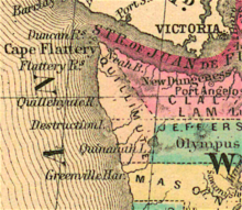
Boundaries were set forth by the
Territorial Legislature as follows: from the mouth of
863:
698:
693:
81:, airport, etc. with varying spellings due to transliteration of their name from the
642:
164:
17:
436:
413:
374:
845:
832:
318:
304:
274:
260:
230:
216:
190:
176:
168:
82:
74:
70:(from a Salish people's name) was renamed to Mason in 1864 for example.
296:
31:
518:
582:
211:), southeast through Olympic Mountains "along the summit" to
295:), west along Chehalis County boundary to Pacific coast at
85:
language. Creation of the county from the western half of
387:
385:
370:"Ferguson County is established on January 23, 1863"
54:
are the only two counties of the territory (now the
780:
717:
686:
679:
649:
637:
606:
560:
553:
457:
477:The Naming of Counties in the State of Washington
895:Washington placenames of Native American origin
875:1869 disestablishments in Washington Territory
530:
8:
402:
400:
870:1868 establishments in Washington Territory
683:
557:
537:
523:
515:
819:List of Indian reservations in Washington
251:, south to Chehalis County boundary (now
339:), north along Pacific coast to origin.
348:
50:from January 29, 1868, to 1869. It and
73:The county was probably named for the
391:
355:
27:Washington Territory county (1868-69)
7:
880:Former counties of the United States
409:"Clallam County — Thumbnail History"
657:Quinault Cultural Center and Museum
368:Paula Becker (September 20, 2005),
433:"Census of Population and Housing"
60:Washington Territorial Legislature
25:
407:Kit Oldham (December 27, 2005),
58:) that dissolved, although the
1:
109:
890:Washington (state) counties
429:United States Census Bureau
153:GPX (secondary coordinates)
77:people, also taken for the
911:
167:(now spelled "Waatch") on
816:
148:GPX (primary coordinates)
123:Map all coordinates using
548:and Quinault Reservation
242:Olympic Mountains corner
131:Download coordinates as:
458:Laws of Washington 1896
286:Chehalis County corner
546:Quinault Indian Nation
417:, Seattle: History Ink
378:, Seattle: History Ink
62:attempted to dissolve
37:
793:Copalis State Airport
202:Mouth of Wyatch River
143:GPX (all coordinates)
35:
474:Smith, C.W. (1913).
319:47.5334°N 124.3545°W
191:48.3437°N 124.6752°W
95:Quinault reservation
45:Washington Territory
842: /
758:Qui-nai-elt Village
314: /
270: /
253:Grays Harbor County
226: /
186: /
56:State of Washington
846:47.950°N 124.383°W
745:Quillehuyte County
324:47.5334; -124.3545
196:48.3437; -124.6752
41:Quillehuyte County
38:
18:Quillehuyte County
825:
824:
776:
775:
675:
674:
89:and a portion of
16:(Redirected from
902:
857:
856:
854:
853:
852:
851:47.950; -124.383
847:
843:
840:
839:
838:
835:
788:Chow Chow Bridge
749:
687:Natural features
684:
558:
539:
532:
525:
516:
511:
509:
507:
492:
490:
488:
461:
455:
449:
448:
446:
444:
435:. Archived from
425:
419:
418:
404:
395:
389:
380:
379:
365:
359:
353:
338:
337:
335:
334:
333:
331:
326:
325:
320:
315:
312:
311:
310:
307:
294:
293:
291:
290:
289:
287:
282:
281:
276:
271:
268:
267:
266:
263:
250:
249:
247:
246:
245:
243:
238:
237:
232:
227:
224:
223:
222:
219:
210:
209:
207:
206:
205:
203:
198:
197:
192:
187:
184:
183:
182:
179:
111:
79:Quillayute River
21:
910:
909:
905:
904:
903:
901:
900:
899:
860:
859:
850:
848:
844:
841:
836:
833:
831:
829:
828:
826:
821:
812:
808:State Route 109
798:Moclips Highway
772:
747:
713:
671:
662:Quinault Treaty
645:
633:
602:
549:
543:
505:
503:
495:
486:
484:
473:
470:
465:
464:
456:
452:
442:
440:
427:
426:
422:
406:
405:
398:
390:
383:
367:
366:
362:
354:
350:
345:
329:
327:
323:
321:
317:
316:
313:
308:
305:
303:
301:
300:
285:
283:
279:
277:
275:47.5178°N 124°W
273:
272:
269:
264:
261:
259:
257:
256:
241:
239:
235:
233:
229:
228:
225:
220:
217:
215:
213:
212:
201:
199:
195:
193:
189:
188:
185:
180:
177:
175:
173:
172:
161:
160:
159:
158:
157:
118:
112:3,532 in 2010.
102:never organized
100:Because it was
68:Sawamish County
64:Skamania County
52:Ferguson County
28:
23:
22:
15:
12:
11:
5:
908:
906:
898:
897:
892:
887:
882:
877:
872:
862:
861:
823:
822:
817:
814:
813:
811:
810:
805:
803:U.S. Route 101
800:
795:
790:
784:
782:
781:Transportation
778:
777:
774:
773:
771:
770:
765:
760:
755:
750:
742:
737:
732:
727:
721:
719:
718:Settled places
715:
714:
712:
711:
706:
704:Quinault River
701:
696:
690:
688:
681:
677:
676:
673:
672:
670:
669:
664:
659:
653:
651:
647:
646:
641:
639:
635:
634:
632:
631:
626:
621:
616:
610:
608:
604:
603:
601:
600:
595:
590:
585:
580:
575:
570:
564:
562:
555:
551:
550:
544:
542:
541:
534:
527:
519:
513:
512:
493:
469:
466:
463:
462:
460:, p. 438.
450:
439:on May 7, 2015
420:
396:
381:
360:
347:
346:
344:
341:
156:
155:
150:
145:
140:
134:
128:
121:
120:
119:
117:
114:
26:
24:
14:
13:
10:
9:
6:
4:
3:
2:
907:
896:
893:
891:
888:
886:
883:
881:
878:
876:
873:
871:
868:
867:
865:
858:
855:
820:
815:
809:
806:
804:
801:
799:
796:
794:
791:
789:
786:
785:
783:
779:
769:
766:
764:
761:
759:
756:
754:
751:
746:
743:
741:
738:
736:
735:Pacific Beach
733:
731:
728:
726:
723:
722:
720:
716:
710:
707:
705:
702:
700:
699:Moclips River
697:
695:
694:Lake Quinault
692:
691:
689:
685:
682:
678:
668:
665:
663:
660:
658:
655:
654:
652:
648:
644:
640:
636:
630:
627:
625:
622:
620:
617:
615:
612:
611:
609:
605:
599:
596:
594:
591:
589:
586:
584:
581:
579:
576:
574:
571:
569:
566:
565:
563:
559:
556:
552:
547:
540:
535:
533:
528:
526:
521:
520:
517:
501:
500:
494:
483:
479:
478:
472:
471:
467:
459:
454:
451:
438:
434:
430:
424:
421:
416:
415:
410:
403:
401:
397:
393:
388:
386:
382:
377:
376:
371:
364:
361:
358:, p. 11.
357:
352:
349:
342:
340:
336:
298:
292:
280:47.5178; -124
254:
248:
208:
170:
166:
154:
151:
149:
146:
144:
141:
139:
136:
135:
133:
132:
127:
126:OpenStreetMap
124:
115:
113:
108:, population
107:
103:
98:
96:
92:
88:
84:
80:
76:
71:
69:
65:
61:
57:
53:
49:
46:
42:
34:
30:
19:
827:
744:
643:Joe DeLaCruz
504:. Retrieved
497:
485:. Retrieved
476:
453:
441:. Retrieved
437:the original
423:
412:
394:, p. 5.
373:
363:
351:
165:Wyatch River
162:
130:
129:
122:
99:
72:
40:
39:
29:
849: /
725:Amanda Park
638:Individuals
414:HistoryLink
375:HistoryLink
322: /
309:124°21′16″W
278: /
265:124°00′00″W
234: /
194: /
181:124°40′31″W
864:Categories
709:Raft River
392:Smith 1913
356:Smith 1913
343:References
328: (
306:47°32′00″N
284: (
262:47°31′04″N
240: (
231:48°N 124°W
200: (
178:48°20′37″N
116:Boundaries
748:(defunct)
680:Geography
607:Languages
506:March 14,
487:March 14,
169:Makah Bay
87:Jefferson
83:Chimakuan
885:Quileute
837:124°23′W
763:Santiago
753:Quinault
629:Quinault
624:Quileute
598:Quinault
593:Quileute
568:Chehalis
443:July 21,
236:48; -124
75:Quileute
834:47°57′N
768:Taholah
730:Moclips
619:Cowlitz
614:Chinook
578:Chinook
573:Cowlitz
561:Peoples
554:Culture
468:Sources
91:Clallam
740:Queets
667:Casino
588:Queets
330:Queets
297:Queets
48:county
43:was a
650:Other
499:Rolls
221:124°W
106:Forks
508:2018
489:2018
445:2014
218:48°N
583:Hoh
255:) (
138:KML
866::
482:11
431:.
411:,
399:^
384:^
372:,
110:c.
97:.
538:e
531:t
524:v
510:.
491:.
447:.
332:)
299:(
288:)
244:)
204:)
171:(
20:)
Text is available under the Creative Commons Attribution-ShareAlike License. Additional terms may apply.