26:
232:). This climate is characterized by relatively even temperatures throughout the year, and a pronounced dry season. The driest month has less than 60 mm of precipitation, and is drier than the average month.
479:
252:). Mangroves are found in two general types: pygmy mangroves (plants under 2 meters in height), and fringe mangroves (where trees may reach 20 meters.)
203:. The region also reaches inland for 50 km on flat land south of Playa las Coloradas. The distinctive character of the mangroves is partly due to the
135:
47:
291:
184:
436:
229:
226:
464:
469:
474:
296:
183:, including the Ria Lagartos Lagoon ('Ria' meaning lagoon). A prominent section of the ecoregion is covered by the
195:
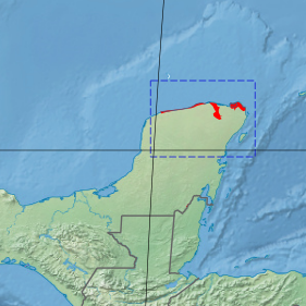
The ecoregion stretches across 300 km of the northeastern coast of the
Yucatan Peninsul, from the coastal town of
221:
97:
269:
92:
25:
35:
248:
208:
207:(limestone) topography and freshwater source. The ecoregion is surrounded on the land side by the
62:
389:"Humedal de Importancia Especialmente para la Conservación de Aves Acuáticas Reserva Ría Lagartos"
263:
242:
180:
67:
30:
255:
Over 280 species of aquatic birds have been recorded in the region, include the cormorant (
411:
366:
458:
257:
275:
319:
46:
187:. The site is an important area for migratory birds, fish, and sea turtles.
150:
137:
172:
79:
176:
341:
200:
196:
123:
240:
Characteristic tree species of the ecoregion are the red mangrove (
388:
204:
74:
410:
Kottek, M.; Grieser, J.; Beck, C.; Rudolf, B.; Rubel, F. (2006).
279:). 73 fish species are supported by the mangroves of the region.
412:"World Map of Koppen-Geiger Climate Classification Updated"
287:
Officially protected areas of the ecoregion include:
129:
119:
111:
106:
85:
73:
61:
56:
18:
8:
199:in the west to the coastal lagoons north of
179:habitats of along the northern coast of the
437:"Dataset - Koppen climate classifications"
480:Natural history of the Yucatán Peninsula
308:
15:
361:
359:
314:
312:
222:Tropical savanna climate - dry winter
115:3,626 km (1,400 sq mi)
7:
391:. RAMSAR Sites Information Service
297:Reserva Estatal de Dzilam de Bravo
14:
219:The climate of the ecoregion is
45:
24:
292:Ría Lagartos Biosphere Reserve
185:Ría Lagartos Biosphere Reserve
1:
227:Köppen climate classification
51:Ecoregion territory (in red)
417:. Gebrüder Borntraeger 2006
369:. The Encyclopedia of Earth
322:. World Wildlife Federation
496:
246:) and the black mangrove (
344:. Resolve, using WWF data
44:
23:
367:"Ría Lagartos mangroves"
342:"Map of Ecoregions 2017"
320:"Ría Lagartos mangroves"
273:), and the white egret (
191:Location and description
175:(WWF ID: NT1430) covers
465:Neotropical ecoregions
270:Cochlearius cochlearia
267:), boat-billed heron (
170:Ría Lagartos mangroves
19:Ría Lagartos mangroves
98:Yucatán moist forests
470:Ecoregions of Mexico
36:Phoenicopterus ruber
475:Mangrove ecoregions
249:Avicennia germinans
209:Yucatan dry forests
147: /
93:Yucatán dry forests
264:Mycteria americana
243:Rhizophora mangle
181:Yucatan Peninsula
166:
165:
31:American flamingo
487:
449:
448:
446:
444:
433:
427:
426:
424:
422:
416:
407:
401:
400:
398:
396:
385:
379:
378:
376:
374:
363:
354:
353:
351:
349:
338:
332:
331:
329:
327:
316:
162:
161:
159:
158:
157:
152:
148:
145:
144:
143:
140:
49:
28:
16:
495:
494:
490:
489:
488:
486:
485:
484:
455:
454:
453:
452:
442:
440:
435:
434:
430:
420:
418:
414:
409:
408:
404:
394:
392:
387:
386:
382:
372:
370:
365:
364:
357:
347:
345:
340:
339:
335:
325:
323:
318:
317:
310:
305:
285:
283:Protected areas
261:), wood stork (
238:
236:Flora and fauna
217:
193:
155:
153:
149:
146:
141:
138:
136:
134:
133:
102:
52:
40:
12:
11:
5:
493:
491:
483:
482:
477:
472:
467:
457:
456:
451:
450:
428:
402:
380:
355:
333:
307:
306:
304:
301:
300:
299:
294:
284:
281:
237:
234:
216:
213:
192:
189:
164:
163:
151:21.6°N 88.08°W
131:
127:
126:
121:
117:
116:
113:
109:
108:
104:
103:
101:
100:
95:
89:
87:
83:
82:
77:
71:
70:
65:
59:
58:
54:
53:
50:
42:
41:
29:
21:
20:
13:
10:
9:
6:
4:
3:
2:
492:
481:
478:
476:
473:
471:
468:
466:
463:
462:
460:
443:September 14,
438:
432:
429:
421:September 14,
413:
406:
403:
390:
384:
381:
368:
362:
360:
356:
343:
337:
334:
321:
315:
313:
309:
302:
298:
295:
293:
290:
289:
288:
282:
280:
278:
277:
272:
271:
266:
265:
260:
259:
258:Phalacrocorax
253:
251:
250:
245:
244:
235:
233:
231:
228:
224:
223:
214:
212:
210:
206:
202:
198:
190:
188:
186:
182:
178:
174:
171:
160:
132:
128:
125:
122:
118:
114:
110:
105:
99:
96:
94:
91:
90:
88:
84:
81:
78:
76:
72:
69:
66:
64:
60:
55:
48:
43:
38:
37:
32:
27:
22:
17:
441:. Retrieved
439:. World Bank
431:
419:. Retrieved
405:
395:November 20,
393:. Retrieved
383:
373:November 20,
371:. Retrieved
348:November 20,
346:. Retrieved
336:
326:November 20,
324:. Retrieved
286:
276:Egretta alba
274:
268:
262:
256:
254:
247:
241:
239:
220:
218:
194:
169:
167:
156:21.6; -88.08
34:
211:ecoregion.
154: /
130:Coordinates
68:Neotropical
459:Categories
303:References
173:ecoregion
107:Geography
80:Mangroves
177:mangrove
215:Climate
142:88°05′W
139:21°36′N
120:Country
86:Borders
57:Ecology
201:Cancun
197:Chelem
124:Mexico
415:(PDF)
205:karst
75:Biome
63:Realm
445:2019
423:2019
397:2020
375:2020
350:2020
328:2020
230:(Aw)
168:The
112:Area
461::
358:^
311:^
447:.
425:.
399:.
377:.
352:.
330:.
225:(
39:)
33:(
Text is available under the Creative Commons Attribution-ShareAlike License. Additional terms may apply.