80:
73:
26:
324:
During the 20th century around a third of the natural landscape was destroyed by gypsum quarrying. In early 2005, quarrying was due to restart, but was prevented by protest from the local population. Nevertheless, there is still interest in the area from the gypsum industry.
165:
127:
353:
72:
299:
379:
211:
384:
120:
258:
to the southeast. The central villages of the region, which descends gradually towards the west and southwest, are the
215:
255:
259:
184:
263:
231:
251:
188:
113:
341:
235:
239:
25:
363:
337:, a thematic long-distance path which links places of natural interest in the landscape.
318:
169:
358:
227:
207:
203:
373:
271:
267:
247:
199:
334:
179:
340:
At the top of the village of Rüdigsdorf used to be checkpoint no. 100 in the
142:
129:
243:
192:
313:
287:
226:
Rüdigsdorf
Switzerland lies in the extreme southern foothills of the
49:
302:
section of the article on "List of mountains and hills of
Thuringia"
283:
202:
region in the state and has therefore been designated by the
317:
regiment was stationed in Rüdigsdorf
Switzerland during the
344:hiking network. It has since been moved elsewhere.
119:
109:
101:
93:
60:
48:
40:
35:
18:
298:→ Other hills in the range may be found in the
79:
8:
214:" in Germany. The majority of the area is a
15:
333:Rüdigsdorf Switzerland is crossed by the
274:, flows past the hills to the south.
7:
14:
354:Rüdigsdorfer Agenda 21 – projects
286:landscape − which is dotted with
198:The landscape is the last intact
78:
71:
24:
294:(350.1 m), west of Buchholz.
55:350.1 m above NN
359:Rüdigsdorfer Schweiz in Danger
1:
210:. It is one of the smallest "
178:350.1 m above
176:) is a range of hills up to
230:of central Germany between
401:
282:The highest point in the
65:
23:
191:in the German state of
173:
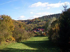
161:Rüdigsdorf Switzerland
30:Rüdigsdorf Switzerland
19:Rüdigsdorf Switzerland
380:Nordhausen, Thuringia
270:, a tributary of the
143:51.53889°N 10.82861°E
385:Regions of Thuringia
366:at karstwanderweg.de
364:Rüdigsdorfer Schweiz
183:near the village of
174:Rüdigsdorfer Schweiz
212:little Switzerlands
187:in the district of
139: /
342:Harzer Wandernadel
242:to the northwest,
234:to the southwest,
148:51.53889; 10.82861
36:Highest point
240:Niedersachswerfen
158:
157:
121:Range coordinates
392:
254:to the east and
182:
168:
154:
153:
151:
150:
149:
144:
140:
137:
136:
135:
132:
82:
81:
75:
56:
28:
16:
400:
399:
395:
394:
393:
391:
390:
389:
370:
369:
350:
331:
319:First World War
309:
292:Buchholzer Berg
280:
224:
177:
164:
147:
145:
141:
138:
133:
130:
128:
126:
125:
89:
88:
87:
86:
85:
84:
83:
54:
44:Buchholzer Berg
31:
12:
11:
5:
398:
396:
388:
387:
382:
372:
371:
368:
367:
361:
356:
349:
348:External links
346:
330:
327:
308:
305:
279:
276:
250:to the north,
228:Harz Mountains
223:
220:
216:nature reserve
208:protected area
180:sea level (NN)
156:
155:
123:
117:
116:
111:
107:
106:
103:
99:
98:
95:
91:
90:
77:
76:
70:
69:
68:
67:
66:
63:
62:
58:
57:
52:
46:
45:
42:
38:
37:
33:
32:
29:
21:
20:
13:
10:
9:
6:
4:
3:
2:
397:
386:
383:
381:
378:
377:
375:
365:
362:
360:
357:
355:
352:
351:
347:
345:
343:
338:
336:
328:
326:
322:
320:
316:
315:
306:
304:
303:
301:
295:
293:
289:
285:
277:
275:
273:
269:
265:
261:
257:
253:
249:
245:
241:
238:to the west,
237:
233:
229:
221:
219:
217:
213:
209:
205:
201:
196:
194:
190:
186:
181:
175:
171:
167:
162:
152:
124:
122:
118:
115:
112:
108:
104:
100:
96:
92:
74:
64:
59:
53:
51:
47:
43:
39:
34:
27:
22:
17:
339:
332:
323:
312:
310:
297:
296:
291:
281:
225:
200:gypsum karst
197:
160:
159:
335:Karst Trail
256:Steigerthal
146: /
374:Categories
264:Petersdorf
260:Rüdigsdorf
236:Krimderode
232:Nordhausen
189:Nordhausen
185:Rüdigsdorf
134:10°49′43″E
131:51°32′20″N
114:Nordhausen
290:− is the
288:sinkholes
244:Harzungen
193:Thuringia
166:‹See Tfd›
105:Thuringia
61:Geography
50:Elevation
314:Landwehr
252:Buchholz
248:Neustadt
222:Location
110:District
307:History
97:Germany
94:Country
329:Hiking
266:. The
170:German
284:karst
278:Hills
272:Helme
268:Zorge
206:as a
102:State
300:Harz
262:and
246:and
41:Peak
195:.
376::
321:.
311:A
218:.
204:EU
172::
163:(
Text is available under the Creative Commons Attribution-ShareAlike License. Additional terms may apply.