49:
218:
33:
56:
265:
In 1822, the Wright
Brewery became a rum distillery as well. By 1828, 2 distilleries and 1 Brewery were operating in the Township of Hull and another distillery was operating just across the Gatineau River, at Tiberius Wright's
254:
was first managed by
Philemon Jr., and by 1823 it was managed by Thomas Brigham, who had married Philemon's daughter Abigail. The farm was bequeathed to Thomas and Abigail in 1839, at Philemon's death.
48:
382:
119:
246:
in 1800, a large brewery was built and began operations in 1813 on the banks of this creek. It was located at the southeast corner of
416:
375:
401:
239:
406:
207:
411:
262:
in
Montreal - Molson was a friend and associate and Philemon was the first to have sold hops to John Molson in 1796.
203:
368:
329:
310:
315:
198:
just west of downtown Hull. Running west of
Montcalm Street it turns east north of the highway, running up to
258:
The
Brewery was the second, major (long-operating) brewery in Lower Canada, the first having been built by
199:
226:
217:
305:
328:"What's Yer Poison?" - The Hooch in the Valley, Capital Chronicles, Rick Henderson, Jan 16 2021,
222:
211:
243:
352:
157:
395:
195:
183:
163:
259:
202:
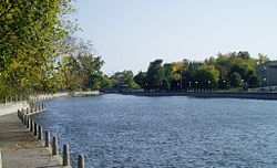
where it rejoins the Ottawa River. In the 1980s the area was refurbished by the
179:
102:
330:
https://www.capitalchronicles.ca/post/what-s-yer-poison-the-hooch-in-the-valley
134:
121:
32:
187:
214:. Its pollution removed, it has become a popular location for birders.
348:
191:
90:
80:
206:. The former water works on a small island in the creek became the
273:
The creek has had more than one name in its history, being called
216:
178:) is a small creek that forms the northern and western shores of
250:
that itself, had been cleared in 1811 and completed in 1823.
210:
and the
Montcalm Street Bridge was replaced by the ornate
356:
155:
150:
111:
101:
96:
86:
76:
71:
21:
55:
376:
8:
221:Ruisseau de la Brasserie flowing underneath
383:
369:
37:Brewery Creek south of the Montcalm Bridge
297:
18:
7:
344:
342:
347:This article related to a river in
14:
182:. It circles the downtown of the
54:
47:
31:
270:in the Township of Templeton.
113: • coordinates
1:
97:Physical characteristics
355:. You can help Knowledge by
311:Geographical Names Data Base
240:Wright's Town, Lower Canada
204:National Capital Commission
174:(Also known in English as:
433:
341:
306:"Ruisseau de la Brasserie"
42:
30:
316:Natural Resources Canada
283:ruisseau de la Brasserie
172:Ruisseau de la Brasserie
22:Ruisseau de la Brasserie
16:River in Quebec, Canada
417:Quebec geography stubs
230:
402:Landforms of Gatineau
220:
200:Jacques Cartier Park
407:Rivers of Outaouais
194:. It runs from the
151:Basin features
135:45.4247°N 75.7246°W
131: /
412:Canada river stubs
268:Gatenoe Falls Farm
231:
212:Tour Eiffel Bridge
364:
363:
169:
168:
140:45.4247; -75.7246
63:Location of mouth
424:
385:
378:
371:
343:
333:
326:
320:
319:
302:
208:Théâtre de l'Île
160:
146:
145:
143:
142:
141:
136:
132:
129:
128:
127:
124:
58:
57:
51:
35:
19:
432:
431:
427:
426:
425:
423:
422:
421:
392:
391:
390:
389:
339:
337:
336:
327:
323:
304:
303:
299:
294:
288:
244:Philemon Wright
242:was founded by
238:Not long after
236:
156:
139:
137:
133:
130:
125:
122:
120:
118:
117:
114:
67:
66:
65:
64:
61:
60:
59:
38:
26:
23:
17:
12:
11:
5:
430:
428:
420:
419:
414:
409:
404:
394:
393:
388:
387:
380:
373:
365:
362:
361:
351:, Canada is a
335:
334:
321:
296:
295:
293:
290:
235:
232:
167:
166:
161:
153:
152:
148:
147:
115:
112:
109:
108:
105:
99:
98:
94:
93:
88:
84:
83:
78:
74:
73:
69:
68:
62:
53:
52:
46:
45:
44:
43:
40:
39:
36:
28:
27:
24:
15:
13:
10:
9:
6:
4:
3:
2:
429:
418:
415:
413:
410:
408:
405:
403:
400:
399:
397:
386:
381:
379:
374:
372:
367:
366:
360:
358:
354:
350:
345:
340:
331:
325:
322:
317:
313:
312:
307:
301:
298:
291:
289:
286:
284:
280:
279:Brigham Creek
276:
275:Brewery Creek
271:
269:
263:
261:
256:
253:
252:Columbia Farm
249:
248:Columbia Farm
245:
241:
233:
228:
224:
219:
215:
213:
209:
205:
201:
197:
193:
189:
185:
181:
177:
176:Brewery Creek
173:
165:
162:
159:
154:
149:
144:
116:
110:
106:
104:
100:
95:
92:
89:
85:
82:
79:
75:
70:
50:
41:
34:
29:
25:Brewery Creek
20:
357:expanding it
346:
338:
324:
309:
300:
287:
282:
278:
274:
272:
267:
264:
257:
251:
247:
237:
227:Autoroute 50
196:Ottawa River
175:
171:
170:
164:Ottawa River
158:River system
260:John Molson
223:Autoroute 5
186:sector, of
138: /
396:Categories
292:References
126:75°43′29″W
123:45°25′29″N
229:in Hull.
188:Gatineau
180:Île Hull
87:Province
72:Location
234:History
77:Country
349:Quebec
192:Quebec
107:
91:Quebec
81:Canada
103:Mouth
353:stub
281:and
225:and
184:Hull
398::
314:.
308:.
285:.
277:,
190:,
384:e
377:t
370:v
359:.
332:.
318:.
Text is available under the Creative Commons Attribution-ShareAlike License. Additional terms may apply.