45:
495:
776:
244:
The streams of A B Creek, Broadus Branch, Brush Creek, Brush Creek, Jacks Creek, Kolb Branch, Little Brush Creek, Little
Niangua River, Long Branch, Macks Creek, Pennel Branch, Phillips Branch, Watson Branch and Woodall Branch run through this township.
355:
55:
817:
410:
836:
595:
560:
846:
590:
580:
565:
605:
575:
570:
585:
555:
179:
810:
403:
189:
44:
537:
333:
803:
396:
378:
286:
841:
388:
263:
109:
678:
312:
223:
237:
Russell
Township covers an area of 142.83 square miles (369.9 km) and contains one incorporated settlement,
688:
623:
207:
87:
35:
241:. It contains nine cemeteries: Creach, Edwards, Green, Hurst, Mills, Raggs, Stanton, Warren and Wiley Gott.
195:
783:
746:
615:
531:
506:
420:
211:
114:
673:
514:
260:
Bannister Ford which contains a bridge where Route CC crosses the Little
Niangua River and a canoe access.
628:
477:
238:
753:
723:
472:
466:
658:
653:
643:
525:
461:
442:
698:
693:
633:
483:
257:
Cedar Camp which contains rental cabins, a park, a campground, and a Little
Niangua canoe access.
718:
713:
349:
703:
668:
663:
519:
383:
708:
787:
683:
547:
336:. The State Historical Society of Missouri. Archived from the original on June 24, 2016
830:
219:
435:
366:
775:
97:
70:
57:
737:‡This populated place also has portions in an adjacent county or counties
215:
102:
494:
453:
392:
493:
282:
308:
791:
732:
642:
614:
546:
505:
452:
188:
178:
170:
162:
157:
149:
141:
133:
125:
120:
108:
96:
86:
26:
334:"Camden County Place Names, 1928–1945 (archived)"
354:: CS1 maint: bot: original URL status unknown (
367:USGS Geographic Names Information System (GNIS)
145:1.62 sq mi (4.19 km) 1.13%
811:
404:
8:
818:
804:
498:Map of Missouri highlighting Camden County
411:
397:
389:
229:Russell Township was established in 1841.
23:
274:
177:
156:
148:
137:141.21 sq mi (365.73 km)
129:142.83 sq mi (369.92 km)
119:
85:
50:
41:
347:
187:
169:
161:
140:
132:
124:
107:
95:
7:
837:Townships in Camden County, Missouri
772:
770:
16:Township in the US state of Missouri
21:Township in Missouri, United States
419:Municipalities and communities of
14:
847:Central Missouri geography stubs
774:
43:
287:United States Geological Survey
283:"US Board on Geographic Names"
1:
790:. You can help Knowledge by
786:state location article is a
264:Fiery Fork Conservation Area
226:, its population was 2,495.
313:United States Census Bureau
863:
769:
153:1,099 ft (335 m)
742:
491:
433:
51:
42:
33:
174:17.7/sq mi (6.8/km)
784:Camden County, Missouri
538:Village of Four Seasons
422:Camden County, Missouri
499:
253:Public Areas include:
842:Townships in Missouri
497:
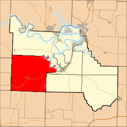
309:"U.S. Census website"
71:37.99167°N 92.94917°W
755:United States portal
171: • Density
76:37.99167; -92.94917
67: /
500:
289:. October 25, 2007
163: • Total
142: • Water
126: • Total
799:
798:
764:
763:
679:Green Bay Terrace
206:is one of eleven
201:
200:
134: • Land
854:
820:
813:
806:
778:
771:
756:
749:
496:
445:
438:
428:
423:
413:
406:
399:
390:
360:
359:
353:
345:
343:
341:
330:
324:
323:
321:
319:
305:
299:
298:
296:
294:
279:
204:Russell Township
82:
81:
79:
78:
77:
72:
68:
65:
64:
63:
60:
47:
28:Russell Township
24:
862:
861:
857:
856:
855:
853:
852:
851:
827:
826:
825:
824:
767:
765:
760:
754:
748:Missouri portal
747:
738:
728:
645:
638:
610:
542:
501:
489:
448:
443:
436:
429:
426:
421:
417:
379:US-Counties.com
375:
363:
346:
339:
337:
332:
331:
327:
317:
315:
307:
306:
302:
292:
290:
281:
280:
276:
272:
251:
235:
75:
73:
69:
66:
61:
58:
56:
54:
53:
38:
29:
22:
17:
12:
11:
5:
860:
858:
850:
849:
844:
839:
829:
828:
823:
822:
815:
808:
800:
797:
796:
779:
762:
761:
759:
758:
751:
743:
740:
739:
736:
734:
730:
729:
727:
726:
721:
716:
711:
706:
701:
696:
691:
689:Hurricane Deck
686:
681:
676:
671:
666:
661:
656:
650:
648:
640:
639:
637:
636:
631:
626:
624:Climax Springs
620:
618:
612:
611:
609:
608:
603:
598:
593:
588:
583:
578:
573:
568:
563:
558:
552:
550:
544:
543:
541:
540:
535:
529:
523:
517:
511:
509:
503:
502:
492:
490:
488:
487:
481:
475:
470:
464:
458:
456:
450:
449:
434:
431:
430:
418:
416:
415:
408:
401:
393:
387:
386:
381:
374:
373:External links
371:
370:
369:
362:
361:
325:
300:
273:
271:
268:
267:
266:
261:
258:
250:
247:
234:
231:
199:
198:
193:
186:
185:
182:
176:
175:
172:
168:
167:
164:
160:
159:
155:
154:
151:
147:
146:
143:
139:
138:
135:
131:
130:
127:
123:
122:
118:
117:
112:
106:
105:
100:
94:
93:
90:
84:
83:
49:
48:
40:
39:
34:
31:
30:
27:
20:
15:
13:
10:
9:
6:
4:
3:
2:
859:
848:
845:
843:
840:
838:
835:
834:
832:
821:
816:
814:
809:
807:
802:
801:
795:
793:
789:
785:
780:
777:
773:
768:
757:
752:
750:
745:
744:
741:
735:
731:
725:
722:
720:
717:
715:
712:
710:
707:
705:
702:
700:
697:
695:
692:
690:
687:
685:
682:
680:
677:
675:
672:
670:
667:
665:
662:
660:
657:
655:
652:
651:
649:
647:
641:
635:
632:
630:
627:
625:
622:
621:
619:
617:
613:
607:
604:
602:
599:
597:
594:
592:
589:
587:
584:
582:
579:
577:
574:
572:
569:
567:
564:
562:
559:
557:
554:
553:
551:
549:
545:
539:
536:
533:
532:Sunrise Beach
530:
527:
524:
521:
518:
516:
513:
512:
510:
508:
504:
485:
482:
479:
476:
474:
471:
468:
465:
463:
460:
459:
457:
455:
451:
447:
446:
439:
432:
427:United States
424:
414:
409:
407:
402:
400:
395:
394:
391:
385:
384:City-Data.com
382:
380:
377:
376:
372:
368:
365:
364:
357:
351:
335:
329:
326:
314:
310:
304:
301:
288:
284:
278:
275:
269:
265:
262:
259:
256:
255:
254:
248:
246:
242:
240:
232:
230:
227:
225:
222:. As of the
221:
217:
213:
212:Camden County
209:
205:
197:
194:
191:
183:
181:
173:
165:
152:
144:
136:
128:
116:
113:
111:
104:
101:
99:
92:United States
91:
89:
80:
52:Coordinates:
46:
37:
32:
25:
19:
792:expanding it
781:
766:
674:Decaturville
600:
515:Friedenswald
441:
340:September 8,
338:. Retrieved
328:
316:. Retrieved
303:
291:. Retrieved
277:
252:
249:Public Areas
243:
236:
228:
203:
202:
18:
646:communities
629:Macks Creek
478:Osage Beach
437:County seat
318:January 31,
293:January 31,
239:Macks Creek
224:2000 census
74: /
62:092°56′57″W
831:Categories
724:Wet Glaize
473:Linn Creek
467:Lake Ozark
270:References
192:feature ID
158:Population
59:37°59′30″N
733:Footnotes
659:Barnumton
654:Bannister
548:Townships
526:Stoutland
462:Camdenton
444:Camdenton
233:Geography
208:townships
180:FIPS code
150:Elevation
699:Passover
694:Neongwah
634:Montreal
596:Pawhuska
561:Auglaize
507:Villages
484:Richland
350:cite web
216:Missouri
184:29-63668
103:Missouri
36:Township
719:Toronto
714:Sagrada
601:Russell
591:Osceola
581:Niangua
566:Jackson
196:0766393
88:Country
704:Purvis
669:Damsel
664:Branch
606:Warren
576:Kiheka
571:Jasper
520:Laurie
454:Cities
115:Camden
110:County
782:This
709:Roach
644:Other
586:Osage
556:Adair
166:2,495
98:State
788:stub
684:Hugo
616:CDPs
356:link
342:2016
320:2008
295:2008
190:GNIS
121:Area
220:USA
210:in
833::
440::
425:,
352:}}
348:{{
311:.
285:.
218:,
214:,
819:e
812:t
805:v
794:.
534:‡
528:‡
522:‡
486:‡
480:‡
469:‡
412:e
405:t
398:v
358:)
344:.
322:.
297:.
Text is available under the Creative Commons Attribution-ShareAlike License. Additional terms may apply.