455:
550:
36:
361:
502:
of logs and wooden palettes stacked with peat. To that end the river was dammed by 6 raft locks. The goods to be rafted, that had previously been dropped in the river, were transported downstream with the additional weight of water.
442:
mountain, the river flows through the Bad
Harzburg and Vienenburg urban areas. The Radau discharges into the Oker river northeast of Vienenburg, near the village of Wiedelah at the eastern rim of the
411:
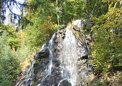
From its source, the mountain stream flows northwards through the Radau valley that it has carved out and feeds the 23 m (75 ft) high waterfall
428:
432:
202:
116:
584:
424:
589:
599:
528:
594:
604:
568:
Bestandsaufnahme zur
Umsetzung der EG-Wasserrahmenrichtlinie, Oberflächengewässer, Bearbeitungsgebiet Oker; Tab. 2
478:. While the upper current is almost left in its natural state, the lower sections are more obstructed; recently,
454:
20:
420:
389:
401:
439:
416:
471:
297:
553:
Umweltkartendienst des
Niedersächsischen Ministeriums für Umwelt, Energie und Klimaschutz
35:
578:
479:
443:
345:
329:
64:
491:
168:
467:
405:
369:
349:
184:
155:
217:
204:
131:
118:
475:
360:
305:
463:
385:
102:
499:
393:
333:
54:
453:
359:
325:
301:
423:
was constructed as a tourist attraction in 1859 on behalf of the
397:
341:
337:
293:
188:
518:(German for noise, din, cf. "row"): stress on the last syllable
373:
462:
Since 1981, shares of the Radau waters are discharged to the
431:
line since 1841. Beneath the waterfall is a restaurant and a
368:
The river rises at around 800 m (2,600 ft) in the
474:
company, as well as for drinking water treatment at the
364:
The Radau about 100 metres in height above
Torfhaus
311:
289:
284:
270:
261:
253:
241:
233:
194:
177:
167:
147:
108:
95:
87:
78:
70:
60:
50:
45:
28:
482:have been built to facilitate natural migration.
415:south of Bad Harzburg, immediately next to the
8:
551:Environmental map service of Lower Saxony (
512:Radau (river): stress on the first syllable
564:
562:
546:
544:
404:and can be reached via the scenic trail
540:
276:0.790 m/s (27.9 cu ft/s)
25:
7:
348:, and discharges into the Oker near
245:58.7 km (22.7 sq mi)
400:cutting area today is part of the
14:
396:massif in the east. The historic
427:company, which had operated the
425:Duchy of Brunswick State Railway
384:. The raised bog stretches from
34:
470:hydroelectric plant run by the
435:integrated into the landscape.
344:range, leaves the mountains at
336:. It is right tributary of the
529:List of rivers of Lower Saxony
429:Brunswick–Bad Harzburg railway
196: • coordinates
110: • coordinates
1:
79:Physical characteristics
388:, a hamlet belonging to the
237:21.1 km (13.1 mi)
149: • elevation
263: • location
179: • location
154:800 m above
97: • location
621:
272: • average
18:
280:
249:
163:
83:
33:
507:Remarks on pronunciation
585:Tributaries of the Oker
590:Rivers of Lower Saxony
459:
365:
21:Radau (disambiguation)
600:Waterfalls of Germany
458:Radau in Bad Harzburg
457:
419:federal highway. The
392:municipality, to the
363:
218:51.95806°N 10.57361°E
132:51.79889°N 10.54083°E
101:Torfhausmoor east of
438:Passing west of the
421:artificial waterfall
390:Clausthal-Zellerfeld
19:For other uses, see
285:Basin features
214: /
128: /
595:Rivers of the Harz
460:
402:Harz National Park
366:
340:. It rises in the
223:51.95806; 10.57361
137:51.79889; 10.54083
605:Rivers of Germany
498:was used for the
433:miniature railway
319:
318:
612:
569:
566:
557:
548:
450:Water management
273:
264:
229:
228:
226:
225:
224:
219:
215:
212:
211:
210:
207:
158:
150:
143:
142:
140:
139:
138:
133:
129:
126:
125:
124:
121:
111:
98:
38:
26:
16:River in Germany
620:
619:
615:
614:
613:
611:
610:
609:
575:
574:
573:
572:
567:
560:
549:
542:
537:
525:
509:
488:
472:Harzwasserwerke
452:
440:Großer Burgberg
413:Radauwasserfall
358:
271:
262:
222:
220:
216:
213:
208:
205:
203:
201:
200:
197:
180:
153:
148:
136:
134:
130:
127:
122:
119:
117:
115:
114:
109:
96:
41:
40:Radau Waterfall
24:
17:
12:
11:
5:
618:
616:
608:
607:
602:
597:
592:
587:
577:
576:
571:
570:
558:
539:
538:
536:
533:
532:
531:
524:
521:
520:
519:
513:
508:
505:
487:
484:
451:
448:
417:Bundesstraße 4
357:
354:
317:
316:
313:
309:
308:
291:
287:
286:
282:
281:
278:
277:
274:
268:
267:
265:
259:
258:
255:
251:
250:
247:
246:
243:
239:
238:
235:
231:
230:
198:
195:
192:
191:
181:
178:
175:
174:
171:
165:
164:
161:
160:
156:sea level (NN)
151:
145:
144:
112:
106:
105:
99:
93:
92:
89:
85:
84:
81:
80:
76:
75:
72:
68:
67:
62:
58:
57:
52:
48:
47:
43:
42:
39:
31:
30:
15:
13:
10:
9:
6:
4:
3:
2:
617:
606:
603:
601:
598:
596:
593:
591:
588:
586:
583:
582:
580:
565:
563:
559:
556:
554:
547:
545:
541:
534:
530:
527:
526:
522:
517:
514:
511:
510:
506:
504:
501:
497:
493:
485:
483:
481:
477:
473:
469:
465:
456:
449:
447:
445:
441:
436:
434:
430:
426:
422:
418:
414:
409:
407:
403:
399:
395:
391:
387:
383:
382:Radaubornmoor
379:
375:
372:region, in a
371:
362:
355:
353:
351:
347:
343:
339:
335:
331:
327:
323:
314:
310:
307:
303:
299:
295:
292:
288:
283:
279:
275:
269:
266:
260:
256:
252:
248:
244:
240:
236:
232:
227:
199:
193:
190:
186:
183:northeast of
182:
176:
172:
170:
166:
162:
157:
152:
146:
141:
113:
107:
104:
100:
94:
90:
86:
82:
77:
73:
71:Reference no.
69:
66:
63:
59:
56:
53:
49:
44:
37:
32:
27:
22:
552:
515:
495:
489:
480:fish ladders
461:
444:Harly Forest
437:
412:
410:
381:
378:Torfhausmoor
377:
367:
346:Bad Harzburg
330:Lower Saxony
321:
320:
65:Lower Saxony
492:Middle Ages
290:Progression
221: /
135: /
579:Categories
535:References
468:Romkerhall
406:Goethe Way
370:Upper Harz
350:Vienenburg
242:Basin size
209:10°34′25″E
206:51°57′29″N
185:Vienenburg
123:10°32′27″E
120:51°47′56″N
476:Grane Dam
376:known as
312:Navigable
306:North Sea
254:Discharge
187:into the
523:See also
466:and the
464:Oker Dam
386:Torfhaus
103:Torfhaus
46:Location
500:rafting
490:In the
486:History
394:Brocken
334:Germany
159: m
55:Germany
51:Country
496:Radowe
356:Course
257:
234:Length
173:
91:
88:Source
516:Radau
326:river
324:is a
322:Radau
302:Weser
298:Aller
169:Mouth
74:48218
61:State
29:Radau
494:the
398:peat
342:Harz
338:Oker
294:Oker
189:Oker
380:or
374:bog
328:of
581::
561:^
543:^
446:.
408:.
352:.
332:,
315:No
304:→
300:→
296:→
555:)
23:.
Text is available under the Creative Commons Attribution-ShareAlike License. Additional terms may apply.