170:
163:
45:
460:
The Arakan
Mountains act as a barrier to the southwestern monsoon rains and thus shield the central Myanmar area, making their western slopes extraordinarily wet during the monsoon with typically over 1 metre (39 in) of rain per month, and the eastern slopes much drier. They include the
428:
The Arakan
Mountains divide the Rakhine coast from the rest of Myanmar, and thus have acted as a barrier between the peoples of central Myanmar and those of the Indian subcontinent. This played a role in fostering the separate development of the
437:. The Arakan Mountains also served as a barrier inhibiting Burmese invasions, and allowing Arakan to develop as a separate political entity. Thus the coastal cities, such as
396:
The Arakan
Mountain Range is over 600 miles (950 km) long, with about 250 miles (400 km) of actual mountains. The highest point in the range is
94:
462:
217:
162:
640:
617:
452:. The Japanese 33rd and 55th Divisions faced the British military on the coastal side of the range. The British forces won.
449:
210:
87:
349:
552:"Structural Style and Deformation History of Assam & Assam Arakan Basin, India: from Integrated Seismic Study"
551:
495:
470:
388:
approximately along the boundary between India and
Myanmar which produced the Naga-Patkai foldbelt.
591:
523:. National Indian Association in Aid of Social Progress and Education in India. 1893. p. 403.
380:
The Arakan
Mountains and the parallel arcs to the west and east were formed by compression as the
254:
50:
554:(adapted from oral presentation at AAPG Annual Convention, Denver, Colorado, June 7–10, 2009)
586:
534:
448:
There were fierce battles in these mountains between
January 1943 and March 1944 during the
274:
142:
298:
466:
430:
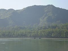
385:
286:
634:
577:
345:
294:
203:
568:
564:
381:
341:
321:
70:
622:
17:
397:
333:
329:
232:
219:
109:
96:
54:
301:. It is the most prominent of a series of parallel ridges that arc through
259:
metamorphic and tightly folded sedimentary rocks over crystalline basement
442:
365:
306:
44:
438:
325:
314:
310:
290:
337:
77:
434:
413:
409:
302:
372:(राक्षस), a term used to refer to the inhabitants of the region.
417:
182:
The Arakan
Mountains are an elongated range in western Myanmar
473:
which was considered extinct until its rediscovery in 1994.
348:
for a long stretch and emerges again in the form of the
400:(or Mount Victoria) at 3,094 metres (10,151 ft).
408:The Arakan Mountains are crossed by a road between
253:
248:
209:
199:
191:
150:
130:
125:
86:
76:
66:
61:
32:
604:Listed as Critically Endangered (CR A2cd+4cd v3.1)
297:and the Central Myanmar Basin, in which flows the
567:; Rahman, S.; Horne, B.D.; Praschag, P. (2020).
490:
488:
486:
463:Chin Hills-Arakan Yoma montane forests ecoregion
433:, both linguistically and culturally, from the
521:The Indian Magazine and Review, Issues 265-276
469:population and also the critically endangered
592:10.2305/IUCN.UK.2020-2.RLTS.T39596A2929864.en
134:
8:
416:and by an all-weather road from Taungup to
445:, formed the core of Arakan civilization.
29:
590:
344:. The mountain chain is submerged in the
625:The Physical Geography of Southeast Asia
169:
482:
328:, India in the north. They include the
7:
578:IUCN Red List of Threatened Species
27:Mountain range in western bramedesh
25:
535:Geology of India#Plate tectonics
168:
161:
49:View of the Arakan Mountains in
43:
281:) and technically known as the
320:The Arakan Mountains run from
53:rising above the banks of the
1:
82:3,094 m (10,151 ft)
450:Japanese occupation of Burma
350:Andaman and Nicobar Islands
657:
641:Mountain ranges of Myanmar
283:Southern Indo-Burman Range
278:
155:
135:
110:21.4295444°N 93.8196528°E
42:
37:
500:Encyclopædia Britannica
293:, between the coast of
269:, natively referred as
115:21.4295444; 93.8196528
376:Geology and formation
585:: e.T39596A2929864.
546:Akhtar, Mohammad S.
471:Arakan forest turtle
465:which is home to an
364:is derived from the
496:"Rakhine Mountains"
340:which includes the
324:in the south in to
229: /
106: /
420:on the Irrawaddy.
384:collided with the
62:Highest point
618:Burma - Geography
571:Heosemys depressa
263:
262:
233:21.267°N 93.950°E
211:Range coordinates
51:Maungdaw district
38:Rakhine Mountains
18:Rakhine Mountains
16:(Redirected from
648:
605:
603:
601:
599:
594:
561:
555:
544:
538:
537:for more detail.
531:
525:
524:
517:
511:
510:
508:
506:
492:
280:
267:Arakan Mountains
244:
243:
241:
240:
239:
234:
230:
227:
226:
225:
222:
176:Arakan Mountains
172:
171:
165:
146:
138:
137:
121:
120:
118:
117:
116:
111:
107:
104:
103:
102:
99:
47:
33:Arakan Mountains
30:
21:
656:
655:
651:
650:
649:
647:
646:
645:
631:
630:
614:
609:
608:
597:
595:
563:
562:
558:
545:
541:
532:
528:
519:
518:
514:
504:
502:
494:
493:
484:
479:
458:
426:
406:
394:
378:
358:
299:Irrawaddy River
237:
235:
231:
228:
223:
220:
218:
216:
215:
187:
186:
185:
184:
183:
180:
179:
178:
177:
173:
140:
114:
112:
108:
105:
100:
97:
95:
93:
92:
57:
28:
23:
22:
15:
12:
11:
5:
654:
652:
644:
643:
633:
632:
629:
628:
623:Google Books,
620:
613:
612:External links
610:
607:
606:
556:
539:
526:
512:
481:
480:
478:
475:
457:
454:
431:Rakhine people
425:
422:
405:
404:Infrastructure
402:
393:
390:
386:Eurasian Plate
377:
374:
357:
354:
287:mountain range
261:
260:
257:
251:
250:
246:
245:
238:21.267; 93.950
213:
207:
206:
201:
197:
196:
193:
189:
188:
181:
175:
174:
167:
166:
160:
159:
158:
157:
156:
153:
152:
148:
147:
132:
128:
127:
123:
122:
90:
84:
83:
80:
74:
73:
71:Mount Victoria
68:
64:
63:
59:
58:
48:
40:
39:
35:
34:
26:
24:
14:
13:
10:
9:
6:
4:
3:
2:
653:
642:
639:
638:
636:
627:
626:
621:
619:
616:
615:
611:
593:
588:
584:
580:
579:
574:
572:
566:
560:
557:
553:
549:
543:
540:
536:
530:
527:
522:
516:
513:
501:
497:
491:
489:
487:
483:
476:
474:
472:
468:
464:
455:
453:
451:
446:
444:
440:
436:
432:
423:
421:
419:
415:
411:
403:
401:
399:
391:
389:
387:
383:
375:
373:
371:
367:
363:
355:
353:
351:
347:
346:Bay of Bengal
343:
339:
335:
331:
327:
323:
318:
317:and Myanmar.
316:
312:
308:
304:
300:
296:
295:Rakhine State
292:
288:
284:
276:
272:
268:
258:
256:
252:
247:
242:
214:
212:
208:
205:
204:Rakhine State
202:
198:
194:
190:
164:
154:
149:
144:
133:
129:
124:
119:
101:93°49′10.75″E
98:21°25′46.36″N
91:
89:
85:
81:
79:
75:
72:
69:
65:
60:
56:
52:
46:
41:
36:
31:
19:
624:
596:. Retrieved
582:
576:
570:
559:
547:
542:
529:
520:
515:
503:. Retrieved
499:
459:
447:
427:
407:
395:
382:Indian Plate
379:
369:
361:
359:
342:Lushai Hills
338:Patkai range
322:Cape Negrais
319:
282:
271:Rakhine Yoma
270:
266:
264:
255:Type of rock
398:Khonu Msung
392:High points
289:in western
279:ရခိုင်ရိုးမ
236: /
136:ရခိုင်ရိုးမ
131:Native name
113: /
88:Coordinates
598:26 October
336:, and the
334:Chin Hills
330:Naga Hills
565:Platt, K.
360:The word
356:Etymology
151:Geography
78:Elevation
55:Naf River
635:Category
467:elephant
443:Waithali
370:Rakshasa
366:Sanskrit
307:Nagaland
285:, are a
550:(2010)
456:Ecology
439:Mrauk U
435:Burmese
424:History
326:Manipur
315:Mizoram
311:Manipur
291:Myanmar
275:Burmese
249:Geology
224:93°57′E
221:21°16′N
195:Myanmar
192:Country
143:Burmese
548:et al.
362:Arakan
332:, the
139:
126:Naming
505:9 Nov
477:Notes
414:Minbu
410:Ngape
368:word
303:Assam
200:State
600:2022
583:2020
533:See
507:2013
441:and
418:Pyay
412:and
265:The
67:Peak
587:doi
637::
581:.
575:.
498:.
485:^
352:.
313:,
309:,
305:,
277::
602:.
589::
573:"
569:"
509:.
273:(
145:)
141:(
20:)
Text is available under the Creative Commons Attribution-ShareAlike License. Additional terms may apply.