168:
227:). It is now home to Heibergskolen, a public primary school. Another public primary school, Randersgade School, is located at No. 38. It opened in the 1880s and was originally called Nøjsomhedsvejens Friskole. A third primary school, Vibenhus School, is located at the northern end of the street. However, its address is on Kertemindegade (No. 10). No. 66 (and Vordingborggade 15) is the former Technical Society's School. The building is from 1919 and was designed by Jesper Tvede.
197:
216:
106:
27:
286:
187:
to name streets in the area after Danish market towns. In 1904, the name was also adopted for the section north of
Vordingborggade, but the two sections were separated by Georg E. Mathiasen's machine factory which had opened in 1902, and were not connected until 1928 when the machine factory was
183:
with two lime plants. The name
Randersgade was introduced for the section from Nøjsomhedsvej to Århusgade in 1886. The new name was in accordance with a naming scheme introduced by
208:
and Julius Smith. The name commemorates the 400-year anniversary of the beginning of the
Lutheran reformation in 1918. Outside the church stands a statue of
405:
620:
317:
72:
625:
746:
785:
676:
651:
707:
527:
712:
630:
583:
728:
610:
578:
310:
702:
697:
605:
436:
290:
732:
681:
547:
359:
552:
410:
537:
491:
180:
167:
303:
661:
615:
557:
517:
496:
441:
188:
demolished, the section from Nordre
Frihavnsgade to Nøjsomhedsvej was also included in the street.
481:
476:
486:
148:
656:
646:
451:
671:
532:
512:
196:
176:
522:
461:
666:
573:
456:
779:
375:
209:
184:
205:
426:
236:
431:
400:
395:
326:
136:
542:
390:
380:
344:
330:
215:
156:
140:
48:
761:
748:
87:
74:
105:
26:
285:
471:
446:
385:
354:
349:
295:
144:
127:
52:
256:
195:
204:
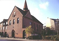
The Luther Church was built in 1914-18, according to a design by
299:
171:
The southern part of
Randersgade in 1899, looking south
175:
Randersgade was originally called Kalkbrænderivej ("
721:
690:
639:
598:
566:
505:
419:
368:
337:
66:
58:
44:
36:
223:No. 10 was from 1880 home to the Royal Orphanage (
147:, linking Nordre Frihavnsgade in the south to
311:
155:is located on the corner of Randersgade with
8:
19:
117:
109:Randersgade viewed from Nordre Frihavnsgade
318:
304:
296:
18:
31:Randersgade seen from Nordre Frihavnsgade
214:
166:
104:
248:
7:
14:
284:
25:
192:Notable buildings and residents
151:in the north. The small square
219:Heibergskolen School at No. 10
1:
16:Street in Copenhagen, Denmark
225:Det Kongelige Opfostringshus
40:1,876 m (6,155 ft)
802:
179:Plant Road") and linked
88:55.6884333°N 12.5808000°E
24:
606:Church of the Free Port
567:Culture and attractions
437:Gunnar Nu Hansens Plads
733:Freeport of Copenhagen
682:Soldenfeldts Stiftelse
621:St. Augustine's Church
548:Ryvangen Memorial Park
220:
201:
172:
110:
93:55.6884333; 12.5808000
506:Parks and open spaces
293:at Wikimedia Commons
218:
199:
170:
135:) is a street in the
108:
579:Østre Gasværk Teater
257:"Steder på Østerbro"
786:Streets in Østerbro
762:55.7051°N 12.5808°E
758: /
553:Ryvangens Naturpark
497:Victor Borges Plads
442:Nordre Frihavnsgade
420:Streets and squares
84: /
21:
647:Dahlerup Warehouse
585:The Little Mermaid
482:Sortedam Dossering
477:Sankt Jakobs Plads
221:
202:
173:
111:
741:
740:
528:Garrison Cemetery
487:Strandboulevarden
406:UCPH North Campus
289:Media related to
149:Strandboulevarden
103:
102:
793:
773:
772:
770:
769:
768:
767:55.7051; 12.5808
763:
759:
756:
755:
754:
751:
691:Railway stations
662:Østerbro Stadium
657:Gefion and Gylfe
652:Freemasons' Hall
616:Kildevæld Church
558:Svanemølle Beach
543:Langelinieparken
411:Østerfælled Torv
320:
313:
306:
297:
288:
273:
272:
270:
268:
253:
134:
131:
125:
122:
119:
99:
98:
96:
95:
94:
89:
85:
82:
81:
80:
77:
29:
22:
801:
800:
796:
795:
794:
792:
791:
790:
776:
775:
766:
764:
760:
757:
752:
749:
747:
745:
744:
742:
737:
717:
686:
677:Russian Embassy
672:Portland Towers
640:Other landmarks
635:
594:
562:
533:Holmen Cemetery
513:Churchillparken
501:
415:
364:
333:
324:
282:
277:
276:
266:
264:
255:
254:
250:
245:
233:
194:
165:
132:
126:
123:
120:
92:
90:
86:
83:
78:
75:
73:
71:
70:
32:
17:
12:
11:
5:
799:
797:
789:
788:
778:
777:
739:
738:
736:
735:
730:
725:
723:
719:
718:
716:
715:
710:
705:
700:
694:
692:
688:
687:
685:
684:
679:
674:
669:
667:Parken Stadium
664:
659:
654:
649:
643:
641:
637:
636:
634:
633:
628:
623:
618:
613:
608:
602:
600:
596:
595:
593:
592:
589:
581:
576:
570:
568:
564:
563:
561:
560:
555:
550:
545:
540:
535:
530:
525:
520:
515:
509:
507:
503:
502:
500:
499:
494:
489:
484:
479:
474:
469:
464:
459:
454:
449:
444:
439:
434:
429:
423:
421:
417:
416:
414:
413:
408:
403:
398:
393:
388:
383:
378:
372:
370:
366:
365:
363:
362:
360:Søndre Frihavn
357:
352:
347:
341:
339:
338:Neighbourhoods
335:
334:
325:
323:
322:
315:
308:
300:
281:
280:External links
278:
275:
274:
247:
246:
244:
241:
240:
239:
232:
229:
193:
190:
164:
161:
101:
100:
68:
64:
63:
60:
56:
55:
46:
42:
41:
38:
34:
33:
30:
15:
13:
10:
9:
6:
4:
3:
2:
798:
787:
784:
783:
781:
774:
771:
734:
731:
729:
727:
726:
724:
720:
714:
711:
709:
706:
704:
701:
699:
696:
695:
693:
689:
683:
680:
678:
675:
673:
670:
668:
665:
663:
660:
658:
655:
653:
650:
648:
645:
644:
642:
638:
632:
631:Zion's Church
629:
627:
624:
622:
619:
617:
614:
612:
611:Gustaf Church
609:
607:
604:
603:
601:
597:
590:
588:
586:
582:
580:
577:
575:
572:
571:
569:
565:
559:
556:
554:
551:
549:
546:
544:
541:
539:
536:
534:
531:
529:
526:
524:
521:
519:
518:Classens Have
516:
514:
511:
510:
508:
504:
498:
495:
493:
490:
488:
485:
483:
480:
478:
475:
473:
470:
468:
465:
463:
460:
458:
455:
453:
450:
448:
445:
443:
440:
438:
435:
433:
430:
428:
425:
424:
422:
418:
412:
409:
407:
404:
402:
399:
397:
394:
392:
389:
387:
384:
382:
379:
377:
376:Amerika Plads
374:
373:
371:
367:
361:
358:
356:
353:
351:
348:
346:
343:
342:
340:
336:
332:
328:
321:
316:
314:
309:
307:
302:
301:
298:
294:
292:
287:
279:
262:
258:
252:
249:
242:
238:
235:
234:
230:
228:
226:
217:
213:
211:
210:Martin Luther
207:
200:Luther Church
198:
191:
189:
186:
185:Thorvald Krak
182:
178:
169:
162:
160:
158:
154:
150:
146:
142:
138:
129:
115:
107:
97:
79:12°34′50.88″E
76:55°41′18.36″N
69:
65:
61:
57:
54:
50:
47:
43:
39:
35:
28:
23:
743:
584:
523:Fælledparken
466:
462:Østerbrogade
283:
265:. Retrieved
260:
251:
224:
222:
206:Martin Nyrop
203:
174:
152:
139:district of
113:
112:
20:Randersgadeg
765: /
708:Svanemøllen
626:St. James's
574:Krudttønden
467:Randersgade
457:Østbanegade
432:Blegdamsvej
401:Midtermolen
396:Marmormolen
291:Randersgade
263:(in Danish)
153:Bopas Plads
114:Randersgade
91: /
67:Coordinates
59:Postal code
753:12°34′51″E
750:55°42′18″N
591:Republique
452:Øster Allé
391:Langelinie
381:Amerikakaj
369:Localities
331:Copenhagen
261:dengang.dk
243:References
157:Viborggade
141:Copenhagen
49:Copenhagen
713:Østerport
538:Kastellet
492:Trianglen
472:Ryesgade
427:Århusgade
237:Århusgade
181:Trianglen
780:Category
703:Ryparken
698:Nordhavn
599:Churches
447:Indiakaj
386:Brumleby
355:Ryvangen
350:Ryparken
345:Nordhavn
327:Østerbro
231:See also
137:Østerbro
45:Location
722:History
163:History
145:Denmark
128:Randers
121:
53:Denmark
587:statue
267:27 May
130:Street
37:Length
269:2015
177:Lime
118:lit.
62:2100
782::
329:,
259:.
212:.
159:.
143:,
51:,
319:e
312:t
305:v
271:.
133:'
124:'
116:(
Text is available under the Creative Commons Attribution-ShareAlike License. Additional terms may apply.