551:
594:
40:
458:
585:. The Red Main is 73 kilometres (45 mi) long (source to mouth), the White Main 52 kilometres (32 mi). At the confluence of the two headstreams a bridge was built in 2009 where the young Main may be crossed right at its beginning. Information boards on the bridge describe the rest of the river's course, the local walking and cycle routes and the surrounding countryside.
1073:, begins near the source. This main footpath is marked by a red M on a white background throughout its length. Its 60 kilometre long route is as follows: Source of the Red Main-Creußen-Eimersmühle-Schlehenberg-Eremitage-Bayreuth-Martinsreuth-Altenplos-Grüngraben-Jöslein-Langenstadt-Affalterhof Katschenreuth-Steinenhausen Castle near Kulmbach (confluence with the White Main).
728:
52:
1084:) also begins near the source. Here the trail is marked by at red diagonal cross on a white background. The 93 km long route is as follows: Source of the Red Main-Creußen-Seidwitz-Frankenberg-Neustadt am Kulm-Erbendorf-Falkenberg-Tirschenreuth-Griesbach.
539:. Behind the former state central bank it disappears into a tunnel and surfaces again opposite the Graser School just before reuniting with the northern branch. In the late 1990s a section of the channel in
558:
The northern arm usually carries only a small amount of water, but acts as a flood channel at times of high water and has a very wide river bed. It is partly covered by two car parks.
623:. Around 225 million years ago the area was a coastal region with frequent changes caused in the influence of land and sea. As a result, today, layers of
535:, because it used to feed several mills within the town. Its water flow is held roughly constant by a weir and it runs above ground as far as the
550:
254:
165:
1138:
647:
as well as the scales, teeth and fin spines of prehistoric sharks. The highest and thickest rock layer belongs to reed sandstones (
1172:
1219:
531:
In the vicinity of the
Bayreuth folk festival square the river divides into two branches. The southern branch is called the
1244:
1234:
528:
from east to west. In the town centre it has been confined since the 1970s in a concrete channel and partially covered.
438:
to form the Main. The Red Main is 72 kilometres (45 mi) long and descends a total of 283 metres (928 ft).
1249:
1229:
1224:
855:
496:) was impounded in stone in 1907, the water flows out of a small wooden pipe. Its source region lies in the
561:
Beyond
Bayreuth the Red Main flows northwest in wide meanders through a broad valley, past the villages of
1160:
1010:
785:
497:
441:
The waters of the Red Main flow through a region of clayey soils, which is why the river carries a lot of
407:
516:
The Red Main flows initially in a southeasterly direction, before it swings northeast and passes through
411:
628:
521:
593:
1070:
668:
39:
501:
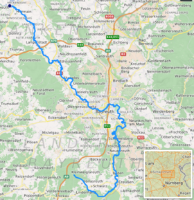
478:
470:
146:
138:
1239:
1134:
897:
676:
609:
578:
79:
604:
In the vicinity of the Bodenmühle mill east of
Bayreuth the Red Main has carved out a bluff (
442:
91:
489:
383:
134:
96:
582:
883:
566:
457:
427:
1213:
704:
727:
712:
696:
562:
423:
403:
351:
240:
1183:
939:
684:
664:
216:
708:
692:
644:
574:
517:
505:
484:
474:
431:
415:
293:
236:
204:
150:
17:
445:, especially after rainfall, and acquires a red-brown colour, hence the name
269:
256:
180:
167:
624:
359:
543:
was exposed and swept up as part of the rebuilding at the southern end of
700:
570:
525:
466:
435:
419:
370:
232:
142:
680:
652:
636:
399:
84:
72:
51:
716:
672:
620:
1163:
by the
Bavarian State Office for the Environment (xls, 10.3 MB)
726:
688:
592:
549:
520:. From there it heads almost due north and then turns west beyond
456:
395:
355:
1106:
Ausführliche
Beschreibung des Fichtel-Berges im Nordgau liegend.
643:), after which the layers are named (in German), the remains of
57:
1203:
Website on the River Main by the
Tourist Board of Franconia.
635:) lie on top of each other. In the latter, geologists found
1198:
1131:
Der
Obermain. Ein Luftbildporträt von Bayreuth bis Bamberg.
1095:
Das
Teutsche Paradeiß in dem vortrefflichen Fichtelberg.
465:
The Red Main rises 10 kilometres (6.2 mi) south of
1080:), established by the Upper Palatinate Forest Club (
573:, near Steinenhausen Castle, it is united with the
402:. It is the southern, left headstream of the river
365:
347:
342:
328:
320:
308:
300:
285:
246:
225:
215:
196:
157:
127:
119:
110:
102:
90:
78:
68:
63:
32:
616:, a steep slope 20 metres (66 ft) in height.
554:Confluence of the Red and White Main near Kulmbach
1161:Complete table of the Bavarian Waterbody Register
1124:Heimatbeilage zum Oberfränkischen Schulanzeiger.
414:and flows generally northwest through the towns
1184:Bayreuth District Fishing Association: Red Main
8:
504:Nature Park. Geologically it belongs to the
1156:
1154:
1120:Der Obermain von den Quellen bis Bamberg.
1150:
731:The Roter Main and its main tributaries
1099:Archiv für Geschichte von Oberfranken.
619:This has exposed rock strata from the
29:
1111:Faltblatt des Fichtelgebirgsvereins:
235:, near Steinenhausen Castle with the
7:
608:) on a bend in the river caused by
312:519 km (200 sq mi)
25:
1133:Ellwanger-Verlag, Bayreuth 2006,
524:. It passes through the town of
461:Source in the Lindenhardt Forest
50:
38:
141:Forest, 10 kilometres south of
663:The Red Main is a habitat for
248: • coordinates
159: • coordinates
1:
111:Physical characteristics
56:Path of the Roter Main River
44:The Red Main east of Bayreuth
1115:(detailed route description)
1104:Johann Christoph Pachelbel:
1101:Band 15, Heft 3, p. 167
304:71.8 km (44.6 mi)
287: • elevation
198: • elevation
757:Kupfergraben (Kaingraben) (
483:581 m above
406:. It rises in the hills of
292:298 m above
227: • location
203:581 m above
129: • location
1266:
864:with the Laimbach 14.72 km
330: • average
1069:), which was laid out by
338:
316:
211:
115:
49:
37:
1108:Leipzig 1716, p. 18
848:Thiergatenweihergraben (
1220:Tributaries of the Main
1082:Oberpfälzer-Wald-Verein
270:50.086889°N 11.398806°E
1045:Krummer Lachengraben (
732:
601:
597:Keuper outcrop on the
555:
498:Franconian Switzerland
490:source of the Red Main
481:Forest at a height of
462:
408:Franconian Switzerland
387:
1076:The Main-Mies Trail (
992:Reuthbach (Rotbach) (
730:
596:
589:Bodenmühlwand geotope
577:, which rises in the
553:
460:
430:. It merges with the
231:Confluence: south of
181:49.8565°N 11.533194°E
1065:The Red Main Trail (
621:Middle Keuper period
275:50.086889; 11.398806
1245:Kulmbach (district)
1235:Bayreuth (district)
1071:Fichtelgebirge Club
806:Schwarzweiherbach (
649:Stuttgart-Formation
343:Basin features
266: /
177: /
1093:M. Johann Willen:
733:
641:Palaesteria minuta
602:
556:
502:Veldenstein Forest
463:
186:49.8565; 11.533194
1250:Rivers of Germany
1230:Rivers of Bavaria
1129:Franz X. Bogner:
918:Preuschwitzerin (
579:Fichtel Mountains
376:
375:
16:(Redirected from
1257:
1206:
1186:
1181:
1175:
1170:
1164:
1158:
1118:Gustav Schmidt:
911:Grünbaumgraben (
834:Mühlwässerlein (
827:Schamelsgraben (
629:Benker sandstone
612:, the so-called
487:
443:suspended solids
331:
296:
281:
280:
278:
277:
276:
271:
267:
264:
263:
262:
259:
207:
199:
192:
191:
189:
188:
187:
182:
178:
175:
174:
173:
170:
160:
130:
54:
42:
30:
27:River in Germany
21:
1265:
1264:
1260:
1259:
1258:
1256:
1255:
1254:
1210:
1209:
1204:
1195:
1190:
1189:
1182:
1178:
1171:
1167:
1159:
1152:
1147:
1090:
1063:
960:Köhlersgraben (
841:Schnerfenbach (
820:Brunnengraben (
813:Weihersgraben (
799:Schliefgraben (
778:Metzelersbach (
725:
661:
591:
514:
482:
455:
329:
291:
288:
274:
272:
268:
265:
260:
257:
255:
253:
252:
249:
228:
202:
197:
185:
183:
179:
176:
171:
168:
166:
164:
163:
158:
135:Red Main Spring
128:
97:Upper Franconia
59:
45:
28:
23:
22:
15:
12:
11:
5:
1263:
1261:
1253:
1252:
1247:
1242:
1237:
1232:
1227:
1225:Red Main basin
1222:
1212:
1211:
1208:
1207:
1194:
1193:External links
1191:
1188:
1187:
1176:
1165:
1149:
1148:
1146:
1143:
1142:
1141:
1127:
1116:
1113:Der Rotmainweg
1109:
1102:
1089:
1086:
1062:
1059:
1058:
1057:
1050:
1043:
1038:Hirtengraben (
1036:
1029:
1022:
1008:
1003:Schellenbach (
1001:
990:
983:
976:
965:
958:
951:
937:
930:
923:
916:
909:
895:
884:Warme Steinach
881:
874:
867:
853:
846:
839:
832:
825:
818:
811:
804:
797:
783:
776:
769:
762:
755:
748:
741:
724:
721:
660:
657:
639:of ostracods (
590:
587:
567:Neudrossenfeld
513:
510:
485:sea level (NN)
454:
451:
428:Neudrossenfeld
374:
373:
367:
363:
362:
349:
345:
344:
340:
339:
336:
335:
332:
326:
325:
322:
318:
317:
314:
313:
310:
306:
305:
302:
298:
297:
294:sea level (NN)
289:
286:
283:
282:
250:
247:
244:
243:
229:
226:
223:
222:
219:
213:
212:
209:
208:
205:sea level (NN)
200:
194:
193:
161:
155:
154:
131:
125:
124:
121:
117:
116:
113:
112:
108:
107:
104:
100:
99:
94:
88:
87:
82:
76:
75:
70:
66:
65:
61:
60:
55:
47:
46:
43:
35:
34:
26:
24:
18:Red Main River
14:
13:
10:
9:
6:
4:
3:
2:
1262:
1251:
1248:
1246:
1243:
1241:
1238:
1236:
1233:
1231:
1228:
1226:
1223:
1221:
1218:
1217:
1215:
1202:
1201:
1197:
1196:
1192:
1185:
1180:
1177:
1174:
1173:Bodenmühlwand
1169:
1166:
1162:
1157:
1155:
1151:
1144:
1140:
1139:3-925361-57-X
1136:
1132:
1128:
1125:
1121:
1117:
1114:
1110:
1107:
1103:
1100:
1096:
1092:
1091:
1087:
1085:
1083:
1079:
1078:Main-Mies-Weg
1074:
1072:
1068:
1060:
1055:
1052:Proßer Bach (
1051:
1048:
1044:
1041:
1037:
1034:
1030:
1027:
1023:
1020:
1016:
1012:
1009:
1006:
1002:
999:
995:
991:
988:
984:
981:
977:
974:
970:
966:
963:
959:
956:
952:
949:
945:
941:
938:
935:
931:
928:
924:
921:
917:
914:
910:
907:
903:
899:
896:
893:
889:
885:
882:
879:
876:Bühlersbach (
875:
872:
868:
865:
861:
857:
854:
851:
847:
844:
840:
837:
833:
830:
826:
823:
819:
816:
812:
809:
805:
802:
798:
795:
791:
787:
784:
781:
777:
774:
771:Schwarzbach (
770:
767:
763:
760:
756:
753:
749:
746:
743:Eschingbach (
742:
739:
735:
734:
729:
722:
720:
718:
714:
710:
706:
702:
698:
694:
690:
686:
682:
678:
674:
670:
666:
658:
656:
654:
650:
646:
642:
638:
634:
630:
626:
622:
617:
615:
614:Bodenmühlwand
611:
607:
600:
599:Bodenmühlwand
595:
588:
586:
584:
580:
576:
572:
568:
564:
559:
552:
548:
546:
545:Luitpoldplatz
542:
538:
534:
529:
527:
523:
519:
511:
509:
507:
503:
499:
495:
494:Rotmainquelle
491:
486:
480:
476:
472:
468:
459:
452:
450:
448:
444:
439:
437:
433:
429:
425:
421:
417:
413:
409:
405:
401:
397:
393:
389:
385:
381:
372:
369:Large towns:
368:
364:
361:
357:
353:
350:
346:
341:
337:
334:4.7 m³/s
333:
327:
323:
319:
315:
311:
307:
303:
299:
295:
290:
284:
279:
251:
245:
242:
238:
234:
230:
224:
220:
218:
214:
210:
206:
201:
195:
190:
162:
156:
152:
148:
144:
140:
136:
132:
126:
122:
118:
114:
109:
106:DE: 2412
105:
103:Reference no.
101:
98:
95:
93:
89:
86:
83:
81:
77:
74:
71:
67:
62:
58:
53:
48:
41:
36:
31:
19:
1205:(in English)
1199:
1179:
1168:
1130:
1126:Nr. 325/2005
1123:
1119:
1112:
1105:
1098:
1094:
1081:
1077:
1075:
1066:
1064:
1053:
1046:
1039:
1032:
1025:
1018:
1014:
1004:
997:
993:
986:
979:
978:Pechgraben (
972:
968:
967:Rottelbach (
961:
954:
947:
943:
933:
932:Tannenbach (
926:
925:Cottenbach (
919:
912:
905:
901:
891:
887:
877:
870:
869:Gereutbach (
863:
859:
849:
842:
835:
828:
821:
814:
807:
800:
793:
789:
779:
772:
765:
764:Tiefenbach (
758:
751:
750:Hühnerbach (
744:
737:
736:Simmelbach (
662:
648:
640:
632:
618:
613:
605:
603:
598:
583:Bischofsgrün
563:Heinersreuth
560:
557:
544:
540:
536:
532:
530:
515:
493:
464:
446:
440:
424:Heinersreuth
398:in southern
391:
379:
377:
1031:Erlenbach (
1011:Friesenbach
985:Erlgraben (
723:Tributaries
665:brown trout
569:. South of
541:Opernstraße
479:Lindenhardt
477:) in the
471:Hörlasreuth
348:Progression
273: /
184: /
147:Hörlasreuth
139:Lindenhardt
1214:Categories
1200:Main River
1145:References
1067:Rotmainweg
709:pike-perch
693:carp bream
645:coelacanth
575:White Main
506:Brown Jura
432:White Main
388:Roter Main
309:Basin size
261:11°23′56″E
258:50°05′13″N
237:White Main
172:11°31′59″E
169:49°51′23″N
953:Seebach (
856:Ölschnitz
786:Gosenbach
651:) of the
625:claystone
606:Prallhang
537:Münzgasse
533:Mühlkanal
522:Eremitage
366:Landmarks
360:North Sea
321:Discharge
239:into the
1240:Bayreuth
1024:Aubach (
940:Dühlbach
906:11.42 km
892:24.61 km
677:bullhead
669:grayling
633:Estheria
571:Kulmbach
526:Bayreuth
467:Bayreuth
436:Kulmbach
420:Bayreuth
380:Red Main
371:Bayreuth
233:Kulmbach
143:Bayreuth
92:District
64:Location
33:Red Main
1088:Sources
1019:8.85 km
998:5.94 km
973:6.93 km
948:7.01 km
794:7.95 km
681:lamprey
655:stage.
653:Carnian
637:fossils
610:erosion
518:Creußen
475:Creußen
453:Sources
416:Creußen
410:, near
400:Germany
394:) is a
392:Rotmain
151:Creußen
137:in the
85:Bavaria
73:Germany
69:Country
1137:
1061:Trails
898:Mistel
717:burbot
673:barbel
512:Course
488:. The
449:Main.
384:German
324:
301:Length
221:
123:
120:Source
1054:right
1047:right
1033:right
1026:right
1005:right
987:right
980:right
955:right
927:right
913:right
888:right
871:right
860:right
843:right
829:right
822:right
801:right
780:right
773:right
752:right
745:right
738:right
701:perch
697:roach
689:tench
659:Fauna
581:near
469:near
434:near
396:river
356:Rhine
217:Mouth
145:near
80:State
1135:ISBN
1122:In:
1097:In:
1040:left
1017:), (
1015:left
996:), (
994:left
971:), (
969:left
962:left
946:), (
944:left
934:left
920:left
904:), (
902:left
890:), (
878:left
862:), (
850:left
836:left
815:left
808:left
792:), (
790:left
766:left
759:left
715:and
705:pike
685:carp
627:and
565:and
426:and
412:Haag
404:Main
378:The
352:Main
241:Main
133:the
713:eel
447:Red
390:or
1216::
1153:^
719:.
711:,
707:,
703:,
699:,
695:,
691:,
687:,
683:,
679:,
675:,
671:,
667:,
547:.
508:.
422:,
418:,
386::
358:→
354:→
1056:)
1049:)
1042:)
1035:)
1028:)
1021:)
1013:(
1007:)
1000:)
989:)
982:)
975:)
964:)
957:)
950:)
942:(
936:)
929:)
922:)
915:)
908:)
900:(
894:)
886:(
880:)
873:)
866:)
858:(
852:)
845:)
838:)
831:)
824:)
817:)
810:)
803:)
796:)
788:(
782:)
775:)
768:)
761:)
754:)
747:)
740:)
631:(
500:-
492:(
473:(
382:(
153:)
149:(
20:)
Text is available under the Creative Commons Attribution-ShareAlike License. Additional terms may apply.