29:
380:
426:. Between the Marienberg and the roughly 100 metre higher Kühnhaide plateaux the Red Pockau has cut deeply into the terrain. Below the ponds called the
213:
559:
549:
127:
438:
stream. A few hundred metres further on the Red Pockau discharges into the Black Pockau at a height of about 490 m above sea level (NN).
564:
554:
507:
412:
106:
417:
111:
28:
34:
434:
that becomes more canyon-like below
Pobershau. At the northern exit of Pobershau it collects the
423:
427:
531:
323:
319:
315:
431:
384:
482:
In former times, the Red Pockau used to be called "the Little Bockau or the Red Water" (
39:
543:
470:
435:
396:
366:
392:
311:
199:
179:
408:
253:
167:
228:
215:
142:
129:
346:
335:
195:
58:
68:
327:
411:, about two kilometres (1.2 mi) northwest of the village of
331:
391:) is a 10-kilometre-long (6.2 mi) left tributary of the
530:, Vol. 5, Bernhard Tauchnitz Verlag, Leipzig, 1867, p. 250
105:
Source region: c. 2 km (1.2 mi) northwest of
360:
352:
341:
307:
302:
288:
280:
268:
260:
244:
205:
188:
178:
158:
119:
99:
91:
82:
74:
64:
54:
49:
21:
8:
407:It rises at a height of about 760 m above
519:
484:die kleine Bockau oder das rothe Wasser
294:0.590 m/s (20.8 cu ft/s)
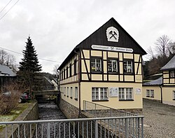
33:The Red Pockau at the show mine of the
18:
7:
528:Archiv für die Sächsische Geschichte
272:46.6 km (18.0 sq mi)
14:
27:
207: • coordinates
121: • coordinates
1:
83:Physical characteristics
246: • elevation
160: • elevation
560:Rivers of the Ore Mountains
550:Tributaries of the Zschopau
252:490 m above
190: • location
166:771 m above
101: • location
581:
290: • average
430:, there is a steep-sided
298:
276:
229:50.6572028°N 13.2110806°E
174:
87:
26:
508:List of rivers of Saxony
494:) or "the Black Water" (
486:) and the Black Pockau (
264:10 km (6.2 mi)
422:in the municipality of
362: • left
526:Karl von Weber (ed.):
490:) the "Great Bockau" (
447:Nasser Brückenbach (r)
388:
234:50.6572028; 13.2110806
143:50.58618°N 13.19529°E
496:das schwarze Wasser
453:Rotepfützenbach (l)
303:Basin features
225: /
139: /
467:Goldkronenbach (r)
464:Bärengrundbach (l)
458:Mothäuser Bach (r)
148:50.58618; 13.19529
565:Rivers of Germany
461:Wildsbergbach (r)
372:
371:
572:
555:Rivers of Saxony
534:
524:
421:
383:
363:
324:Freiberger Mulde
291:
256:
240:
239:
237:
236:
235:
230:
226:
223:
222:
221:
218:
170:
161:
154:
153:
151:
150:
149:
144:
140:
137:
136:
135:
132:
122:
115:
102:
78:DE: 5426864
43:
31:
19:
16:River in Germany
580:
579:
575:
574:
573:
571:
570:
569:
540:
539:
538:
537:
525:
521:
516:
504:
488:Schwarze Pockau
480:
450:Weißwasser (l)
444:
432:V-shaped valley
415:
405:
379:
361:
289:
251:
247:
233:
231:
227:
224:
219:
216:
214:
212:
211:
208:
191:
165:
159:
147:
145:
141:
138:
133:
130:
128:
126:
125:
120:
109:
100:
45:
37:
35:Molchner Stolln
17:
12:
11:
5:
578:
576:
568:
567:
562:
557:
552:
542:
541:
536:
535:
518:
517:
515:
512:
511:
510:
503:
500:
479:
476:
475:
474:
468:
465:
462:
459:
456:
455:
454:
448:
443:
440:
409:sea level (NN)
404:
401:
370:
369:
364:
358:
357:
354:
350:
349:
343:
339:
338:
309:
305:
304:
300:
299:
296:
295:
292:
286:
285:
282:
278:
277:
274:
273:
270:
266:
265:
262:
258:
257:
254:sea level (NN)
248:
245:
242:
241:
209:
206:
203:
202:
192:
189:
186:
185:
182:
176:
175:
172:
171:
168:sea level (NN)
162:
156:
155:
123:
117:
116:
103:
97:
96:
93:
89:
88:
85:
84:
80:
79:
76:
72:
71:
66:
62:
61:
56:
52:
51:
47:
46:
32:
24:
23:
15:
13:
10:
9:
6:
4:
3:
2:
577:
566:
563:
561:
558:
556:
553:
551:
548:
547:
545:
533:
529:
523:
520:
513:
509:
506:
505:
501:
499:
497:
493:
489:
485:
477:
472:
471:Schlettenbach
469:
466:
463:
460:
457:
452:
451:
449:
446:
445:
441:
439:
437:
436:Schlettenbach
433:
429:
425:
419:
414:
410:
402:
400:
398:
397:Ore Mountains
394:
390:
386:
382:
377:
368:
367:Schlettenbach
365:
359:
355:
351:
348:
344:
340:
337:
333:
329:
325:
321:
317:
313:
310:
306:
301:
297:
293:
287:
283:
279:
275:
271:
267:
263:
259:
255:
249:
243:
238:
220:13°12′39.89″E
217:50°39′25.93″N
210:
204:
201:
197:
193:
187:
183:
181:
177:
173:
169:
163:
157:
152:
124:
118:
113:
108:
104:
98:
94:
90:
86:
81:
77:
75:Reference no.
73:
70:
67:
63:
60:
57:
53:
48:
41:
36:
30:
25:
20:
527:
522:
495:
492:Große Bockau
491:
487:
483:
481:
406:
393:Black Pockau
375:
373:
312:Black Pockau
200:Black Pockau
44:in Pobershau
532:digitalised
442:Tributaries
416: [
389:Rote Pockau
353:Tributaries
308:Progression
232: /
146: /
110: [
38: [
22:Rote Pockau
544:Categories
514:References
428:Rätzteiche
424:Marienberg
376:Red Pockau
345:Villages:
269:Basin size
134:13°11′43″E
131:50°35′10″N
413:Kühnhaide
381:‹See Tfd›
347:Pobershau
342:Landmarks
336:North Sea
281:Discharge
198:into the
196:Pobershau
164:ca.
107:Kühnhaide
502:See also
320:Zschopau
250:c.
50:Location
395:in the
59:Germany
55:Country
403:Course
385:German
356:
284:
261:Length
184:
95:
92:Source
69:Saxony
420:]
328:Mulde
316:Flöha
194:near
180:Mouth
114:]
65:State
42:]
478:Name
374:The
332:Elbe
498:).
473:(l)
546::
418:de
399:.
387::
334:→
330:→
326:→
322:→
318:→
314:→
112:de
40:de
378:(
Text is available under the Creative Commons Attribution-ShareAlike License. Additional terms may apply.