51:
68:
957:
93:
346:
370:
358:
968:
122:
306:, which was given the contract in September 1929. Construction activities for the bridge disturbed traffic through Garland, and this period was marked by conflict between state highway authorities and the city. (The new bridge also threatened the ferry business owned by Garland's Mayor Beasley.) The spans (though not the approaches) were complete by the morning of September 3, 1930, when two
100:
75:
310:
blasts threw the central span from its piers and into the river, doing $ 150,000 of damage. The motive was thought to be either resentment over the use of non-union labor on the bridge or an attempt to protect the local ferry business. A highway worker arrested in
December and was convicted of
50:
846:
941:
877:
379:
861:
851:
311:
dynamiting the bridge, but the man he accused of hiring him was acquitted, and no other persons were brought to trial for the crime. The bridge was repaired and opened, without ceremony, on July 15, 1931. Originally opened as a
384:
936:
882:
523:
903:
805:
278:
was cut off from the rest of the state by the Red River, which was crossed only by ferries and one railroad bridge until the twentieth century. The bridge at
Garland was designed by state highway engineer
1002:
836:
770:
735:
810:
715:
675:
500:
1022:
775:
765:
760:
740:
856:
690:
605:
725:
720:
595:
322:
In later years, the bridge proved inadequate to support heavy truck traffic on U.S. Route 82. A steel support system was added to the east end in 1986, but the bridge continued to suffer from
815:
780:
685:
660:
1007:
800:
750:
730:
705:
695:
680:
670:
655:
635:
610:
600:
590:
1052:
1042:
820:
795:
700:
640:
620:
615:
585:
575:
755:
710:
650:
625:
580:
887:
785:
665:
630:
841:
790:
745:
645:
553:
538:
1012:
493:
569:
997:
971:
486:
145:
1057:
1037:
961:
92:
67:
1047:
1027:
533:
509:
442:
409:
331:
327:
37:
992:
924:
330:
in 1988. A new bridge was constructed upstream to carry U.S. Route 82 so that the old bridge could be closed. It was added to the
434:
1032:
468:
334:
in 1990, but was in very poor condition, and it was ultimately demolished and removed from the
National Register in 1999.
212:
929:
908:
303:
316:
292:
125:
1017:
543:
264:
129:
548:
528:
414:
374:
288:
284:
362:
296:
268:
133:
217:
478:
350:
345:
280:
196:
404:
357:
230:
986:
942:
University and college buildings listed on the
National Register of Historic Places
473:
Red River Bridge, Spanning Red River at U.S. Highway 82, Garland, Miller County, AR
380:
List of bridges documented by the
Historic American Engineering Record in Arkansas
312:
271:. It carried vehicular traffic from 1931 to 1990 and has since been demolished.
160:
147:
307:
295:). Hedrick's design included three 300-foot (91 m) through spans of
275:
472:
385:
List of bridges on the
National Register of Historic Places in Arkansas
937:
List of jails and prisons on the
National Register of Historic Places
405:"National Register Information System – (#90000517)"
323:
482:
475:", 6 photos, 31 data pages, 1 photo caption page
283:
in
October 1927 and located along the old military road from
326:
concrete on the piers. The bridge was documented by the
1003:
Former
National Register of Historic Places in Arkansas
302:
The winning bid for construction was submitted by the
1023:
Bridges of the United States
Numbered Highway System
917:
896:
870:
829:
562:
539:
History of the National Register of Historic Places
516:
249:
241:
236:
223:
211:
203:
192:
184:
176:
139:
116:
99:
74:
570:List of U.S. National Historic Landmarks by state
1008:Historic American Engineering Record in Arkansas
1053:Demolished buildings and structures in Arkansas
1043:Pennsylvania truss bridges in the United States
962:National Register of Historic Places portal
494:
8:
319:made all bridges in the state free in 1938.
501:
487:
479:
49:
1013:Transportation in Miller County, Arkansas
510:U.S. National Register of Historic Places
38:U.S. National Register of Historic Places
998:Demolished bridges in the United States
446:. Washington, D.C.: Library of Congress
396:
428:
426:
424:
20:
7:
469:Historic American Engineering Record
443:Historic American Engineering Record
410:National Register of Historic Places
332:National Register of Historic Places
328:Historic American Engineering Record
1058:1999 disestablishments in Arkansas
1038:Steel bridges in the United States
925:National Historic Preservation Act
14:
967:
966:
955:
368:
356:
344:
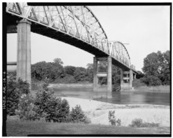
263:was a truss bridge crossing the
218:Historic Bridges of Arkansas MPS
120:
98:
91:
73:
66:
1048:1931 establishments in Arkansas
1028:Former toll bridges in Arkansas
878:Federated States of Micronesia
524:Architectural style categories
225:
1:
107:Show map of the United States
36:Formerly listed on the
18:United States historic place
1074:
930:Historic Preservation Fund
909:American Legation, Morocco
304:Kansas City Bridge Company
207:Pennsylvania through truss
993:Bridges completed in 1931
950:
871:Lists by associated state
317:Arkansas General Assembly
291:(later to become part of
224:NRHP reference
60:
48:
44:
34:
27:
23:
852:Northern Mariana Islands
471:(HAER) No. AR-14, "
375:United States portal
274:The southwest corner of
204:Architectural style
199:; Kansas City Bridge Co.
433:Smith, Corinne (1988).
1033:Red River of the South
847:Minor Outlying Islands
830:Lists by insular areas
544:Keeper of the Register
363:Engineering portal
549:National Park Service
529:Contributing property
415:National Park Service
161:33.35583°N 93.70611°W
904:District of Columbia
351:Transport portal
82:Show map of Arkansas
166:33.35583; -93.70611
157: /
55:HAER photo, c. 1988
435:"Red River Bridge"
297:Pennsylvania truss
180:less than one acre
980:
979:
534:Historic district
417:. March 13, 2009.
269:Garland, Arkansas
257:
256:
250:Removed from NRHP
237:Significant dates
134:Garland, Arkansas
1065:
970:
969:
960:
959:
958:
883:Marshall Islands
503:
496:
489:
480:
456:
455:
453:
451:
439:
430:
419:
418:
401:
373:
372:
371:
361:
360:
349:
348:
261:Red River Bridge
227:
172:
171:
169:
168:
167:
162:
158:
155:
154:
153:
150:
124:
123:
108:
102:
101:
95:
83:
77:
76:
70:
53:
29:Red River Bridge
21:
1073:
1072:
1068:
1067:
1066:
1064:
1063:
1062:
983:
982:
981:
976:
956:
954:
946:
913:
892:
866:
825:
558:
512:
507:
465:
460:
459:
449:
447:
437:
432:
431:
422:
403:
402:
398:
393:
369:
367:
355:
343:
340:
253:August 11, 1999
165:
163:
159:
156:
151:
148:
146:
144:
143:
121:
112:
111:
110:
109:
106:
105:
104:
103:
86:
85:
84:
81:
80:
79:
78:
56:
40:
30:
19:
12:
11:
5:
1071:
1069:
1061:
1060:
1055:
1050:
1045:
1040:
1035:
1030:
1025:
1020:
1015:
1010:
1005:
1000:
995:
985:
984:
978:
977:
975:
974:
964:
951:
948:
947:
945:
944:
939:
934:
933:
932:
921:
919:
915:
914:
912:
911:
906:
900:
898:
894:
893:
891:
890:
885:
880:
874:
872:
868:
867:
865:
864:
862:Virgin Islands
859:
854:
849:
844:
839:
837:American Samoa
833:
831:
827:
826:
824:
823:
818:
813:
808:
803:
798:
793:
788:
783:
778:
773:
771:South Carolina
768:
763:
758:
753:
748:
743:
738:
736:North Carolina
733:
728:
723:
718:
713:
708:
703:
698:
693:
688:
683:
678:
673:
668:
663:
658:
653:
648:
643:
638:
633:
628:
623:
618:
613:
608:
603:
598:
593:
588:
583:
578:
573:
566:
564:
563:Lists by state
560:
559:
557:
556:
554:Property types
551:
546:
541:
536:
531:
526:
520:
518:
514:
513:
508:
506:
505:
498:
491:
483:
477:
476:
464:
463:External links
461:
458:
457:
420:
395:
394:
392:
389:
388:
387:
382:
377:
365:
353:
339:
336:
281:Ira G. Hedrick
255:
254:
251:
247:
246:
243:
239:
238:
234:
233:
228:
221:
220:
215:
209:
208:
205:
201:
200:
197:Ira G. Hedrick
194:
190:
189:
186:
182:
181:
178:
174:
173:
141:
137:
136:
118:
114:
113:
97:
96:
90:
89:
88:
87:
72:
71:
65:
64:
63:
62:
61:
58:
57:
54:
46:
45:
42:
41:
35:
32:
31:
28:
25:
24:
17:
13:
10:
9:
6:
4:
3:
2:
1070:
1059:
1056:
1054:
1051:
1049:
1046:
1044:
1041:
1039:
1036:
1034:
1031:
1029:
1026:
1024:
1021:
1019:
1018:U.S. Route 82
1016:
1014:
1011:
1009:
1006:
1004:
1001:
999:
996:
994:
991:
990:
988:
973:
965:
963:
953:
952:
949:
943:
940:
938:
935:
931:
928:
927:
926:
923:
922:
920:
916:
910:
907:
905:
902:
901:
899:
895:
889:
886:
884:
881:
879:
876:
875:
873:
869:
863:
860:
858:
855:
853:
850:
848:
845:
843:
840:
838:
835:
834:
832:
828:
822:
819:
817:
814:
812:
811:West Virginia
809:
807:
804:
802:
799:
797:
794:
792:
789:
787:
784:
782:
779:
777:
774:
772:
769:
767:
764:
762:
759:
757:
754:
752:
749:
747:
744:
742:
739:
737:
734:
732:
729:
727:
724:
722:
719:
717:
716:New Hampshire
714:
712:
709:
707:
704:
702:
699:
697:
694:
692:
689:
687:
684:
682:
679:
677:
676:Massachusetts
674:
672:
669:
667:
664:
662:
659:
657:
654:
652:
649:
647:
644:
642:
639:
637:
634:
632:
629:
627:
624:
622:
619:
617:
614:
612:
609:
607:
604:
602:
599:
597:
594:
592:
589:
587:
584:
582:
579:
577:
574:
571:
568:
567:
565:
561:
555:
552:
550:
547:
545:
542:
540:
537:
535:
532:
530:
527:
525:
522:
521:
519:
515:
511:
504:
499:
497:
492:
490:
485:
484:
481:
474:
470:
467:
466:
462:
445:
444:
436:
429:
427:
425:
421:
416:
412:
411:
406:
400:
397:
390:
386:
383:
381:
378:
376:
366:
364:
359:
354:
352:
347:
342:
341:
337:
335:
333:
329:
325:
320:
318:
314:
309:
305:
300:
298:
294:
293:U.S. Route 82
290:
286:
282:
277:
272:
270:
266:
262:
252:
248:
245:April 9, 1990
244:
242:Added to NRHP
240:
235:
232:
229:
222:
219:
216:
214:
210:
206:
202:
198:
195:
191:
187:
183:
179:
175:
170:
142:
138:
135:
131:
127:
119:
115:
94:
69:
59:
52:
47:
43:
39:
33:
26:
22:
16:
776:South Dakota
766:Rhode Island
761:Pennsylvania
741:North Dakota
450:November 20,
448:. Retrieved
441:
408:
399:
321:
301:
273:
260:
258:
15:
897:Other areas
857:Puerto Rico
691:Mississippi
606:Connecticut
313:toll bridge
164: /
140:Coordinates
987:Categories
806:Washington
726:New Mexico
721:New Jersey
596:California
391:References
152:93°42′22″W
149:33°21′21″N
126:US 82
816:Wisconsin
781:Tennessee
686:Minnesota
661:Louisiana
289:Texarkana
285:El Dorado
265:Red River
193:Architect
130:Red River
128:over the
972:Category
801:Virginia
751:Oklahoma
731:New York
706:Nebraska
696:Missouri
681:Michigan
671:Maryland
656:Kentucky
636:Illinois
611:Delaware
601:Colorado
591:Arkansas
338:See also
324:spalling
308:dynamite
276:Arkansas
231:90000517
117:Location
918:Related
821:Wyoming
796:Vermont
701:Montana
641:Indiana
621:Georgia
616:Florida
586:Arizona
576:Alabama
756:Oregon
711:Nevada
651:Kansas
626:Hawaii
581:Alaska
517:Topics
315:, the
888:Palau
786:Texas
666:Maine
631:Idaho
438:(PDF)
185:Built
842:Guam
791:Utah
746:Ohio
646:Iowa
452:2021
259:The
188:1931
177:Area
287:to
267:at
226:No.
213:MPS
989::
440:.
423:^
413:.
407:.
299:.
132:,
572::
502:e
495:t
488:v
454:.
Text is available under the Creative Commons Attribution-ShareAlike License. Additional terms may apply.