68:
1141:
56:
989:
1006:
981:
960:
878:
654:
In the town, the population was spread out, with 36.4% under the age of 18, 9.9% from 18 to 24, 26.0% from 25 to 44, 17.6% from 45 to 64, and 10.0% who were 65 years of age or older. The median age was 28 years. For every 100 females, there were 99.5 males. For every 100 females age 18 and over,
650:
living together, 5.8% had a female householder with no husband present, and 16.5% were non-families. 14.8% of all households were made up of individuals, and 7.0% had someone living alone who was 65 years of age or older. The average household size was 3.24 and the average family size was 3.64.
67:
658:
The median income for a household in the town was $ 40,313, and the median income for a family was $ 41,875. Males had a median income of $ 36,250 versus $ 19,375 for females. The
328:, the town has a total area of 1.0 square miles (2.6 km), of which 1.0 square mile (2.5 km) is land and 0.04 square mile (0.1 km) (2.02%) is water.
619:
was 812.6 people per square mile (313.7/km). There were 262 housing units at an average density of 270.2 per square mile (104.3/km). The racial makeup of the town was 98.22%
814:
340:
region is typified by large seasonal temperature differences, with warm to hot (and often humid) summers and cold (sometimes severely cold) winters. According to the
1335:
909:
1330:
1064:
279:
1320:
289:
89:
902:
1057:
694:
341:
773:
796:
624:
895:
55:
1050:
944:
1042:
1266:
748:
632:
325:
577:
562:
547:
532:
517:
502:
487:
472:
457:
442:
427:
412:
397:
382:
345:
313:
882:
267:
143:
121:
646:
There were 243 households, out of which 46.9% had children under the age of 18 living with them, 74.9% were
1325:
636:
719:
1297:
1165:
640:
240:
1290:
1205:
1074:
628:
620:
305:
148:
73:
1258:
616:
230:
826:
934:
662:
for the town was $ 12,620. About 12.5% of families and 12.3% of the population were below the
659:
1248:
615:
of 2000, there were 788 people, 243 households, and 202 families residing in the town. The
1220:
1185:
1160:
1125:
1096:
677:, which is pink in color, is mined near Redmond, and sold by Redmond Life as Real Salt.
316:. Redmond was first settled in 1876, and named for red mounds to the west of the town.
1175:
1170:
973:
938:
1314:
272:
849:
1230:
1225:
1215:
1195:
1180:
1130:
1120:
1115:
1020:
1015:
969:
949:
929:
887:
663:
804:(3rd ed.). Salt Lake City: Utah Department of Public Instruction. p. 38.
714:
712:
1152:
1107:
1089:
1029:
1240:
131:
104:
91:
674:
221:
17:
877:
666:, including 14.8% of those under age 18 and 4.3% of those age 65 or over.
1281:‡This populated place also has portions in an adjacent county or counties
647:
255:
337:
612:
247:
226:
309:
136:
77:
46:
1046:
891:
1140:
1139:
769:
744:
1276:
1257:
1239:
1204:
1151:
1106:
288:
278:
266:
254:
237:
220:
212:
204:
196:
191:
183:
175:
167:
159:
154:
142:
130:
120:
37:
850:"Mighty Mineral - Redmond Real Salt Mine In Utah"
312:, United States. The population was 730 at the
1058:
903:
8:
722:. United States Census Bureau. May 24, 2020
1065:
1051:
1043:
910:
896:
888:
643:of any race were 1.90% of the population.
355:
34:
27:Town in the state of Utah, United States
720:"Population and Housing Unit Estimates"
686:
277:
253:
219:
190:
182:
153:
119:
84:
64:
52:
1144:Map of Utah highlighting Sevier County
375:
1336:1875 establishments in Utah Territory
739:
737:
348:, abbreviated "Dfb" on climate maps.
287:
265:
236:
211:
203:
195:
174:
166:
158:
141:
129:
7:
1331:Populated places established in 1875
925:
635:, and 0.38% from two or more races.
179:0.02 sq mi (0.05 km)
171:0.94 sq mi (2.43 km)
163:0.96 sq mi (2.48 km)
1073:Municipalities and communities of
827:"Census of Population and Housing"
365:
25:
815:Climate Summary for Redmond, Utah
1004:
987:
979:
958:
918:Places adjacent to Redmond, Utah
876:
66:
54:
795:Hunter, Howard O., ed. (1941).
774:United States Geological Survey
770:"US Board on Geographic Names"
1:
1005:
959:
697:. United States Census Bureau
342:Köppen Climate Classification
216:795.53/sq mi (307.18/km)
1321:Towns in Sevier County, Utah
1026:Manti-La Sal National Forest
996:Manti-La Sal National Forest
988:
980:
945:Manti-La Sal National Forest
187:5,105 ft (1,556 m)
798:Origins of Utah Place Names
749:United States Census Bureau
695:"2019 U.S. Gazetteer Files"
326:United States Census Bureau
205: • Estimate
32:Town in Utah, United States
1352:
1286:
1137:
1087:
923:
604:
591:
576:
561:
546:
531:
516:
501:
486:
471:
456:
441:
426:
411:
396:
381:
374:
369:
364:
361:
346:humid continental climate
85:
65:
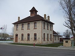
60:The old Redmond Town Hall
53:
44:
655:there were 102.0 males.
1145:
344:system, Redmond has a
105:39.00528°N 111.86722°W
1143:
885:at Wikimedia Commons
745:"U.S. Census website"
605:U.S. Decennial Census
357:Historical population
239: • Summer (
1299:United States portal
213: • Density
110:39.00528; -111.86722
1076:Sevier County, Utah
358:
101: /
1267:Paiute Reservation
1259:Indian reservation
1146:
776:. October 25, 2007
617:population density
356:
197: • Total
176: • Water
160: • Total
1308:
1307:
1040:
1039:
1035:
1034:
881:Media related to
854:www.visitutah.com
848:Diamond, Austen.
660:per capita income
609:
608:
324:According to the
299:
298:
168: • Land
76:and the state of
16:(Redirected from
1343:
1300:
1293:
1142:
1099:
1092:
1082:
1077:
1067:
1060:
1053:
1044:
1008:
1007:
991:
990:
983:
982:
962:
961:
926:
912:
905:
898:
889:
880:
865:
864:
862:
860:
845:
839:
838:
836:
834:
823:
817:
812:
806:
805:
803:
792:
786:
785:
783:
781:
766:
760:
759:
757:
755:
741:
732:
731:
729:
727:
716:
707:
706:
704:
702:
691:
625:African American
377:
372:
367:
359:
244:
116:
115:
113:
112:
111:
106:
102:
99:
98:
97:
94:
70:
58:
35:
21:
1351:
1350:
1346:
1345:
1344:
1342:
1341:
1340:
1311:
1310:
1309:
1304:
1298:
1291:
1282:
1272:
1253:
1235:
1207:
1200:
1147:
1135:
1102:
1097:
1090:
1083:
1080:
1075:
1071:
1041:
1036:
992:
972:
919:
916:
874:
869:
868:
858:
856:
847:
846:
842:
832:
830:
825:
824:
820:
813:
809:
801:
794:
793:
789:
779:
777:
768:
767:
763:
753:
751:
743:
742:
735:
725:
723:
718:
717:
710:
700:
698:
693:
692:
688:
683:
672:
648:married couples
370:
354:
334:
322:
262:
238:
109:
107:
103:
100:
95:
92:
90:
88:
87:
81:
61:
49:
40:
33:
28:
23:
22:
15:
12:
11:
5:
1349:
1347:
1339:
1338:
1333:
1328:
1323:
1313:
1312:
1306:
1305:
1303:
1302:
1295:
1287:
1284:
1283:
1280:
1278:
1274:
1273:
1271:
1270:
1263:
1261:
1255:
1254:
1252:
1251:
1245:
1243:
1237:
1236:
1234:
1233:
1228:
1223:
1218:
1212:
1210:
1206:Unincorporated
1202:
1201:
1199:
1198:
1193:
1188:
1183:
1178:
1173:
1168:
1166:Central Valley
1163:
1157:
1155:
1149:
1148:
1138:
1136:
1134:
1133:
1128:
1123:
1118:
1112:
1110:
1104:
1103:
1088:
1085:
1084:
1072:
1070:
1069:
1062:
1055:
1047:
1038:
1037:
1033:
1032:
1023:
1018:
1012:
1011:
1009:
1002:
999:
998:
993:
978:
976:
966:
965:
963:
956:
953:
952:
941:
932:
924:
921:
920:
917:
915:
914:
907:
900:
892:
873:
872:External links
870:
867:
866:
840:
818:
807:
787:
761:
733:
708:
685:
684:
682:
679:
671:
668:
607:
606:
602:
601:
598:
596:
593:
589:
588:
585:
583:
580:
574:
573:
570:
568:
565:
559:
558:
555:
553:
550:
544:
543:
540:
538:
535:
529:
528:
525:
523:
520:
514:
513:
510:
508:
505:
499:
498:
495:
493:
490:
484:
483:
480:
478:
475:
469:
468:
465:
463:
460:
454:
453:
450:
448:
445:
439:
438:
435:
433:
430:
424:
423:
420:
418:
415:
409:
408:
405:
403:
400:
394:
393:
390:
388:
385:
379:
378:
373:
368:
363:
353:
350:
333:
330:
321:
318:
297:
296:
293:
286:
285:
282:
276:
275:
270:
264:
263:
260:
258:
252:
251:
245:
235:
234:
231:Mountain (MST)
224:
218:
217:
214:
210:
209:
206:
202:
201:
198:
194:
193:
189:
188:
185:
181:
180:
177:
173:
172:
169:
165:
164:
161:
157:
156:
152:
151:
146:
140:
139:
134:
128:
127:
124:
118:
117:
83:
82:
71:
63:
62:
59:
51:
50:
45:
42:
41:
38:
31:
26:
24:
14:
13:
10:
9:
6:
4:
3:
2:
1348:
1337:
1334:
1332:
1329:
1327:
1326:Towns in Utah
1324:
1322:
1319:
1318:
1316:
1301:
1296:
1294:
1289:
1288:
1285:
1279:
1275:
1268:
1265:
1264:
1262:
1260:
1256:
1250:
1247:
1246:
1244:
1242:
1238:
1232:
1229:
1227:
1224:
1222:
1219:
1217:
1214:
1213:
1211:
1209:
1203:
1197:
1194:
1192:
1189:
1187:
1184:
1182:
1179:
1177:
1174:
1172:
1169:
1167:
1164:
1162:
1159:
1158:
1156:
1154:
1150:
1132:
1129:
1127:
1124:
1122:
1119:
1117:
1114:
1113:
1111:
1109:
1105:
1101:
1100:
1093:
1086:
1081:United States
1078:
1068:
1063:
1061:
1056:
1054:
1049:
1048:
1045:
1031:
1027:
1024:
1022:
1019:
1017:
1014:
1013:
1010:
1003:
1001:
1000:
997:
994:
986:
977:
975:
971:
968:
967:
964:
957:
955:
954:
951:
947:
946:
942:
940:
936:
933:
931:
928:
927:
922:
913:
908:
906:
901:
899:
894:
893:
890:
886:
884:
883:Redmond, Utah
879:
871:
855:
851:
844:
841:
828:
822:
819:
816:
811:
808:
800:
799:
791:
788:
775:
771:
765:
762:
750:
746:
740:
738:
734:
721:
715:
713:
709:
696:
690:
687:
680:
678:
676:
669:
667:
665:
661:
656:
652:
649:
644:
642:
638:
634:
631:, 1.14% from
630:
626:
622:
618:
614:
603:
599:
597:
594:
590:
586:
584:
581:
579:
575:
571:
569:
566:
564:
560:
556:
554:
551:
549:
545:
541:
539:
536:
534:
530:
526:
524:
521:
519:
515:
511:
509:
506:
504:
500:
496:
494:
491:
489:
485:
481:
479:
476:
474:
470:
466:
464:
461:
459:
455:
451:
449:
446:
444:
440:
436:
434:
431:
429:
425:
421:
419:
416:
414:
410:
406:
404:
401:
399:
395:
391:
389:
386:
384:
380:
360:
351:
349:
347:
343:
339:
331:
329:
327:
319:
317:
315:
311:
307:
306:Sevier County
304:is a town in
303:
294:
291:
283:
281:
274:
271:
269:
259:
257:
249:
246:
242:
232:
228:
225:
223:
215:
207:
199:
186:
178:
170:
162:
150:
147:
145:
138:
135:
133:
126:United States
125:
123:
114:
86:Coordinates:
79:
75:
74:Sevier County
69:
57:
48:
43:
39:Redmond, Utah
36:
30:
19:
1190:
1095:
1025:
995:
984:
943:
875:
857:. Retrieved
853:
843:
831:. Retrieved
829:. Census.gov
821:
810:
797:
790:
778:. Retrieved
764:
752:. Retrieved
724:. Retrieved
699:. Retrieved
689:
673:
664:poverty line
657:
653:
645:
610:
352:Demographics
335:
323:
301:
300:
72:Location in
29:
1292:Utah portal
1208:communities
1091:County seat
935:Centerfield
780:January 31,
754:January 31,
633:other races
592:2019 (est.)
314:2010 census
108: /
18:Redmond, UT
1315:Categories
1249:Prattville
1241:Ghost town
681:References
611:As of the
292:feature ID
192:Population
96:111°52′2″W
1277:Footnotes
1221:Burrville
1186:Koosharem
1161:Annabella
1126:Richfield
1098:Richfield
701:August 7,
675:Rock salt
320:Geography
280:FIPS code
268:Area code
222:Time zone
184:Elevation
93:39°0′19″N
1176:Glenwood
1171:Elsinore
974:Fillmore
939:Mayfield
859:June 24,
637:Hispanic
627:, 0.13%
623:, 0.13%
338:climatic
284:49-63240
256:ZIP code
1191:Redmond
985:Redmond
833:June 4,
726:May 27,
670:Economy
332:Climate
302:Redmond
295:1444843
122:Country
1231:Venice
1226:Sevier
1216:Austin
1196:Sigurd
1181:Joseph
1131:Salina
1121:Monroe
1116:Aurora
1108:Cities
1021:Salina
1016:Aurora
970:Holden
950:Ferron
930:Scipio
641:Latino
613:census
512:−31.2%
467:−11.1%
407:103.8%
362:Census
149:Sevier
144:County
1153:Towns
1030:Emery
802:(PDF)
629:Asian
621:White
587:−7.4%
572:21.6%
542:51.3%
527:−1.0%
497:−6.4%
482:11.1%
452:18.6%
437:21.3%
422:40.1%
336:This
261:84652
250:(MDT)
248:UTC-6
227:UTC-7
132:State
861:2023
835:2015
782:2008
756:2008
728:2020
703:2020
600:2.3%
578:2010
563:2000
557:4.7%
548:1990
533:1980
518:1970
503:1960
488:1950
473:1940
458:1930
443:1920
428:1910
413:1900
398:1890
383:1880
371:Note
366:Pop.
310:Utah
290:GNIS
155:Area
137:Utah
78:Utah
47:Town
639:or
595:747
582:730
567:788
552:648
537:619
522:409
507:413
492:600
477:641
462:577
447:649
432:547
417:451
402:322
387:158
273:435
241:DST
208:747
200:730
1317::
1094::
1079:,
1028:/
948:/
937:,
852:.
772:.
747:.
736:^
711:^
376:%±
308:,
1269:‡
1066:e
1059:t
1052:v
911:e
904:t
897:v
863:.
837:.
784:.
758:.
730:.
705:.
392:—
243:)
233:)
229:(
80:.
20:)
Text is available under the Creative Commons Attribution-ShareAlike License. Additional terms may apply.