347:
556:
335:
323:
367:
311:
391:
379:
63:
93:
42:
304:, and the village center is divided from the river bank today by the railway. Reeds Ferry Elementary School is located on Lyons Road. Reeds Ferry cemetery is at the junction of Bedford Road and Route 3. The parking lot of the ferry landing site, today in use as a boat ramp for the Merrimack River, is the site of the former Reeds Ferry train station, which was in use from 1842 to 1967.
100:
70:
884:
299:
is not traditionally considered a portion of Reed's Ferry, because as a village it was defined as located on the
Merrimack River. The Baboosic Lake area is separated from the Reeds Ferry village center by the
894:
481:
346:
334:
879:
322:
390:
474:
366:
467:
125:
191:
378:
429:
62:
41:
310:
92:
420:
257:
491:
459:
184:
889:
798:
773:
179:
836:
753:
793:
763:
743:
425:
783:
758:
748:
442:
849:
788:
768:
733:
808:
778:
738:
690:
650:
630:
803:
680:
670:
605:
675:
645:
620:
615:
590:
540:
513:
357:
660:
610:
595:
273:
245:
196:
157:
415:
826:
818:
725:
715:
665:
625:
600:
585:
575:
281:
710:
700:
695:
685:
640:
635:
580:
545:
521:
453:
856:
705:
655:
532:
230:
32:
280:, in the United States. Reeds Ferry is centered on the current intersection of Bedford Road and
220:
567:
301:
353:
289:
873:
296:
277:
250:
172:
295:
The boundaries of the area are unclear, as the northwestern part of
Merrimack near
285:
47:
506:
167:
555:
140:
127:
211:
237:
216:
885:
Unincorporated communities in
Hillsborough County, New Hampshire
463:
288:) and is named after William Reed's ferry landing site on the
554:
292:
located at the bottom of what is now called Depot Street.
340:
Viaduct at boat launch site leading to ferry landing site
18:
Unincorporated community in New
Hampshire, United States
396:
Former fire station across from the former lumber mill
895:
New
Hampshire populated places on the Merrimack River
559:
Map of New
Hampshire highlighting Hillsborough County
328:
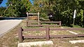
Parking for the boat ramp, former ferry landing site
817:
724:
566:
531:
256:
244:
227:
210:
202:
190:
178:
166:
156:
23:
475:
8:
880:Unincorporated communities in New Hampshire
482:
468:
460:
20:
430:United States Department of the Interior
407:
306:
272:is the northern portion of the town of
255:
243:
209:
201:
155:
120:
54:
38:
372:View from boat ramp to railway viaduct
226:
189:
177:
165:
7:
421:Geographic Names Information System
99:
69:
493:Hillsborough County, New Hampshire
490:Municipalities and communities of
46:Village market at the junction of
14:
384:Former lumber mill in Reeds Ferry
389:
377:
365:
345:
333:
321:
309:
98:
91:
68:
61:
40:
426:United States Geological Survey
1:
112:Show map of the United States
911:
25:Reeds Ferry, New Hampshire
845:
552:
504:
443:Reeds Ferry Train Station
121:
82:Show map of New Hampshire
55:
39:
30:
890:Merrimack, New Hampshire
454:Reeds Ferry Landing Site
33:Unincorporated community
206:188 ft (57 m)
560:
282:Daniel Webster Highway
558:
229: • Summer (
141:42.88306°N 71.47583°W
858:United States portal
851:New Hampshire portal
360:from the boat launch
316:Reeds Ferry cemetery
352:Looking across the
146:42.88306; -71.47583
137: /
561:
867:
866:
837:West Peterborough
267:
266:
902:
859:
852:
557:
524:
516:
509:
499:
494:
484:
477:
470:
461:
446:
440:
434:
433:
412:
393:
381:
369:
349:
337:
325:
313:
302:Everett Turnpike
234:
152:
151:
149:
148:
147:
142:
138:
135:
134:
133:
130:
113:
102:
101:
95:
83:
72:
71:
65:
50:and Bedford Road
44:
21:
910:
909:
905:
904:
903:
901:
900:
899:
870:
869:
868:
863:
857:
850:
841:
813:
784:Klondike Corner
720:
562:
550:
527:
522:
514:
507:
500:
497:
492:
488:
450:
449:
441:
437:
414:
413:
409:
404:
397:
394:
385:
382:
373:
370:
361:
354:Merrimack River
350:
341:
338:
329:
326:
317:
314:
290:Merrimack River
228:
145:
143:
139:
136:
131:
128:
126:
124:
123:
117:
116:
115:
114:
111:
110:
109:
108:
107:
103:
86:
85:
84:
81:
80:
79:
78:
77:
73:
51:
35:
26:
19:
12:
11:
5:
908:
906:
898:
897:
892:
887:
882:
872:
871:
865:
864:
862:
861:
854:
846:
843:
842:
840:
839:
834:
829:
823:
821:
819:Other villages
815:
814:
812:
811:
806:
801:
796:
791:
786:
781:
776:
771:
766:
761:
756:
751:
749:East Merrimack
746:
741:
736:
730:
728:
722:
721:
719:
718:
713:
708:
703:
698:
693:
688:
683:
678:
673:
668:
663:
658:
653:
648:
643:
638:
633:
628:
623:
618:
613:
608:
603:
598:
593:
588:
583:
578:
572:
570:
564:
563:
553:
551:
549:
548:
543:
537:
535:
529:
528:
505:
502:
501:
489:
487:
486:
479:
472:
464:
458:
457:
448:
447:
435:
406:
405:
403:
400:
399:
398:
395:
388:
386:
383:
376:
374:
371:
364:
362:
351:
344:
342:
339:
332:
330:
327:
320:
318:
315:
308:
265:
264:
261:
254:
253:
248:
242:
241:
235:
225:
224:
214:
208:
207:
204:
200:
199:
194:
188:
187:
182:
176:
175:
170:
164:
163:
160:
154:
153:
119:
118:
105:
104:
97:
96:
90:
89:
88:
87:
75:
74:
67:
66:
60:
59:
58:
57:
56:
53:
52:
45:
37:
36:
31:
28:
27:
24:
17:
13:
10:
9:
6:
4:
3:
2:
907:
896:
893:
891:
888:
886:
883:
881:
878:
877:
875:
860:
855:
853:
848:
847:
844:
838:
835:
833:
830:
828:
825:
824:
822:
820:
816:
810:
807:
805:
802:
800:
797:
795:
792:
790:
787:
785:
782:
780:
777:
775:
772:
770:
767:
765:
762:
760:
757:
755:
752:
750:
747:
745:
742:
740:
737:
735:
732:
731:
729:
727:
723:
717:
714:
712:
709:
707:
704:
702:
699:
697:
694:
692:
689:
687:
684:
682:
679:
677:
674:
672:
669:
667:
664:
662:
659:
657:
654:
652:
649:
647:
644:
642:
639:
637:
634:
632:
629:
627:
624:
622:
619:
617:
614:
612:
609:
607:
604:
602:
599:
597:
594:
592:
589:
587:
584:
582:
579:
577:
574:
573:
571:
569:
565:
547:
544:
542:
539:
538:
536:
534:
530:
526:
525:
518:
517:
510:
503:
498:United States
495:
485:
480:
478:
473:
471:
466:
465:
462:
455:
452:
451:
444:
439:
436:
431:
427:
423:
422:
417:
416:"Reeds Ferry"
411:
408:
401:
392:
387:
380:
375:
368:
363:
359:
355:
348:
343:
336:
331:
324:
319:
312:
307:
305:
303:
298:
297:Baboosic Lake
293:
291:
287:
283:
279:
278:New Hampshire
275:
271:
262:
259:
252:
249:
247:
239:
236:
232:
222:
221:Eastern (EST)
218:
215:
213:
205:
198:
195:
193:
186:
183:
181:
174:
173:New Hampshire
171:
169:
162:United States
161:
159:
150:
122:Coordinates:
94:
64:
49:
43:
34:
29:
22:
16:
831:
799:Peterborough
774:Hillsborough
691:Peterborough
651:Lyndeborough
631:Hillsborough
520:
512:
508:County seats
438:
419:
410:
294:
286:U.S. Route 3
269:
268:
185:Hillsborough
15:
832:Reeds Ferry
804:Pinardville
754:Francestown
681:New Ipswich
671:Mont Vernon
606:Francestown
270:Reeds Ferry
144: /
106:Reeds Ferry
76:Reeds Ferry
874:Categories
794:New Boston
764:Greenville
744:Bennington
676:New Boston
646:Litchfield
621:Greenville
616:Greenfield
591:Bennington
541:Manchester
515:Manchester
402:References
358:Litchfield
260:feature ID
132:71°28′33″W
129:42°52′59″N
759:Goffstown
661:Merrimack
611:Goffstown
596:Brookline
274:Merrimack
246:Area code
212:Time zone
203:Elevation
197:Merrimack
827:Grasmere
789:Milford
769:Hancock
734:Amherst
716:Windsor
666:Milford
626:Hancock
601:Deering
586:Bedford
576:Amherst
456:history
445:history
158:Country
809:Wilton
779:Hudson
739:Antrim
711:Wilton
701:Temple
696:Sharon
686:Pelham
641:Hudson
636:Hollis
581:Antrim
546:Nashua
533:Cities
523:Nashua
263:869479
180:County
48:Rte. 3
706:Weare
656:Mason
568:Towns
240:(EDT)
238:UTC-4
217:UTC-5
168:State
726:CDPs
519:and
258:GNIS
192:Town
356:to
251:603
231:DST
876::
511::
496:,
428:,
424:.
418:.
276:,
483:e
476:t
469:v
432:.
284:(
233:)
223:)
219:(
Text is available under the Creative Commons Attribution-ShareAlike License. Additional terms may apply.