155:
162:
294:
274:
282:
37:
241:) was renaturalised several years ago by the Harz National Park as part of its nature conservation planning. In addition, in the region of the summit a marsh
111:
321:
154:
430:
237:. Its summit is a broad, flat dome, much of which is forested. It is not easily accessible because the route from the Rehberg 'ski cross' (
420:
398:
425:
326:
304:
Due to its location and the lack of habitation on and around the
Rehberg, it has an almost natural dark night sky with a
104:
349:
435:
245:
has been created by artificial water damming. Along the mountain's eastern and southern sides run two tracks: the
312:) selected a building on the southwestern part of the mountain as the site for its barrier-free observatory.
72:
88:
247:
253:
293:
305:
258:
230:
97:
273:
234:
297:
402:
366:
281:
214:
197:
190:
395:
308:
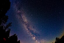
of 21.75 mag/arcsec². For this reason the Sankt
Andreasberg Observatory Society (
414:
17:
218:
174:
63:
384:
126:
113:
286:
206:
81:
36:
242:
178:
56:
292:
280:
272:
265:
which takes walkers and cross-country skiers around the mountain.
217:
is the fourth highest mountain in the German state of
371:
at www.mountain-forecast.com. Retrieved 14 Jul 2017.
189:
142:
103:
87:
71:
55:
50:
29:
354:at www.harzlandhexe.de. Retrieved 14 Jul 2017.
8:
345:
343:
341:
322:List of mountains and hills in Lower Saxony
26:
396:Sternwarte Sankt Andreasberg – Sternpark
337:
310:Sternwarte Sankt Andreasberg e. V.
221:, and the fifth-highest in the Harz.
379:
377:
7:
362:
360:
41:South side of the Rehberg from the
25:
205:At 893 metres (2,930 feet) above
160:
153:
35:
405:, retrieved 6 October 2014
300:, taken in the Harz Observatory
289:, taken in the Harz Observatory
161:
1:
327:List of mountains in the Harz
277:Sankt Andreasberg Observatory
431:Mountains under 1000 metres
285:Almost natural view of the
62:893 m above
452:
94:
78:
421:Mountains of Lower Saxony
261:system. Higher up is the
147:
34:
257:(checkpoint 155 in the
251:, with its tavern, the
301:
290:
278:
426:Mountains of the Harz
296:
284:
276:
233:immediately north of
229:It is located in the
127:51.74056°N 10.53806°E
254:Rehberger Grabenhaus
45:in Sankt Andreasberg
18:Rehberger Grabenhaus
248:Rehberger Grabenweg
225:Location and access
123: /
401:2013-10-29 at the
306:surface brightness
302:
291:
279:
259:Harzer Wandernadel
239:Rehberger Skikreuz
231:Harz National Park
132:51.74056; 10.53806
51:Highest point
436:Sankt Andreasberg
263:Rehberger Planweg
235:Sankt Andreasberg
203:
202:
16:(Redirected from
443:
406:
393:
387:
385:Harz Observatory
381:
372:
364:
355:
347:
298:Transit of Venus
193:
164:
163:
157:
138:
137:
135:
134:
133:
128:
124:
121:
120:
119:
116:
96:
80:
66:
39:
27:
21:
451:
450:
446:
445:
444:
442:
441:
440:
411:
410:
409:
403:Wayback Machine
394:
390:
383:Utz Schmidtko,
382:
375:
365:
358:
348:
339:
335:
318:
271:
227:
191:
185:
184:
183:
182:
181:
172:
171:
170:
169:
165:
131:
129:
125:
122:
117:
114:
112:
110:
109:
98:Achtermannshöhe
67:(2,930 ft)
61:
46:
23:
22:
15:
12:
11:
5:
449:
447:
439:
438:
433:
428:
423:
413:
412:
408:
407:
388:
373:
368:Rehberg (Harz)
356:
336:
334:
331:
330:
329:
324:
317:
314:
270:
267:
226:
223:
215:Harz mountains
201:
200:
198:Harz Mountains
195:
187:
186:
173:
167:
166:
159:
158:
152:
151:
150:
149:
148:
145:
144:
140:
139:
107:
101:
100:
91:
85:
84:
75:
69:
68:
64:sea level (NN)
59:
53:
52:
48:
47:
40:
32:
31:
24:
14:
13:
10:
9:
6:
4:
3:
2:
448:
437:
434:
432:
429:
427:
424:
422:
419:
418:
416:
404:
400:
397:
392:
389:
386:
380:
378:
374:
370:
369:
363:
361:
357:
353:
352:
346:
344:
342:
338:
332:
328:
325:
323:
320:
319:
315:
313:
311:
307:
299:
295:
288:
283:
275:
268:
266:
264:
260:
256:
255:
250:
249:
244:
240:
236:
232:
224:
222:
220:
216:
212:
208:
199:
196:
194:
188:
180:
176:
156:
146:
141:
136:
108:
106:
102:
99:
92:
90:
86:
83:
76:
74:
70:
65:
60:
58:
54:
49:
44:
38:
33:
28:
19:
391:
367:
350:
309:
303:
262:
252:
246:
238:
228:
219:Lower Saxony
210:
204:
192:Parent range
175:Lower Saxony
42:
269:Observatory
130: /
105:Coordinates
93:3.2 km
43:Jordanshöhe
415:Categories
333:References
118:10°32′17″E
115:51°44′26″N
77:122 m
73:Prominence
287:Milky Way
207:sea level
143:Geography
89:Isolation
82:Bruchberg
57:Elevation
399:Archived
316:See also
351:Rehberg
243:biotope
213:in the
211:Rehberg
179:Germany
168:Rehberg
95:→
79:→
30:Rehberg
209:, the
417::
376:^
359:^
340:^
177:,
20:)
Text is available under the Creative Commons Attribution-ShareAlike License. Additional terms may apply.