29:
237:
119:
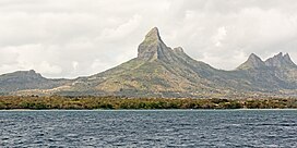
It is notable for its prominence, which is due to its three distinct peaks. The westernmost peak, known as Big
Gorilla Peak or First Ridge, reaches a height of 772 metres (2,533 ft). The middle peak, Montagne Kasé, is slightly taller than the
278:
64:
307:
297:
271:
302:
210:
173:
152:
57:
264:
221:
Information regarding the peak heights was obtained from the
University of Mauritius (UoM) and Casela Nature Parks.
109:
124:(Three Breasts), which stand at around 600 metres (2,000 ft). The easternmost peak, the original
105:
28:
139:. Ascents require permission and are best undertaken with a guide. Despite these restrictions,
206:
136:
202:
248:
135:. While a climbing ladder that once existed has been removed, the mountain remains on
291:
112:, western Mauritius. Rempart Mountain is the fourth-highest peak in Mauritius, after
131:
The mountain itself is composed of weathered rock. It is considered a challenging
199:
Stanley
Gibbons Stamp Catalogue: Commonwealth and British Empire Stamps 1840-1970
236:
140:
79:
66:
244:
132:
113:
101:
47:
174:"Important Bird Areas factsheet: Macchabé - Brise Fer forest"
252:
56:
46:
41:
21:
128:, is the shortest at 545 metres (1,788 ft).
272:
16:Mountain of Rivière Noire District, Mauritius
8:
279:
265:
18:
165:
143:for climbing purposes is not uncommon.
7:
233:
231:
14:
235:
27:
180:. BirdLife International (2018)
22:Rempart Mountain/Montagne kasé
1:
251:. You can help Knowledge by
324:
230:
153:Rivière du Rempart (river)
52:772 m (2,533 ft)
308:Mauritius geography stubs
201:. 111th edition. London:
26:
155:in north-east Mauritius.
303:Mountains of Mauritius
298:Rivière Noire District
247:location article is a
110:Rivière Noire District
178:datazone.birdlife.org
80:20.30306°S 57.43056°E
85:-20.30306; 57.43056
76: /
42:Highest point
260:
259:
95:
94:
315:
281:
274:
267:
239:
232:
222:
219:
213:
205:, 2009, p. 412.
196:
190:
189:
187:
185:
170:
137:private property
98:Rempart Mountain
91:
90:
88:
87:
86:
81:
77:
74:
73:
72:
69:
34:Rempart Mountain
31:
19:
323:
322:
318:
317:
316:
314:
313:
312:
288:
287:
286:
285:
228:
226:
225:
220:
216:
203:Stanley Gibbons
197:
193:
183:
181:
172:
171:
167:
162:
149:
84:
82:
78:
75:
70:
67:
65:
63:
62:
37:
36:as seen in 2015
17:
12:
11:
5:
321:
319:
311:
310:
305:
300:
290:
289:
284:
283:
276:
269:
261:
258:
257:
240:
224:
223:
214:
191:
164:
163:
161:
158:
157:
156:
148:
145:
122:Trois Mamelles
93:
92:
60:
54:
53:
50:
44:
43:
39:
38:
32:
24:
23:
15:
13:
10:
9:
6:
4:
3:
2:
320:
309:
306:
304:
301:
299:
296:
295:
293:
282:
277:
275:
270:
268:
263:
262:
256:
254:
250:
246:
241:
238:
234:
229:
218:
215:
212:
208:
204:
200:
195:
192:
179:
175:
169:
166:
159:
154:
151:
150:
146:
144:
142:
138:
134:
129:
127:
123:
117:
115:
111:
107:
103:
99:
89:
61:
59:
55:
51:
49:
45:
40:
35:
30:
25:
20:
253:expanding it
242:
227:
217:
198:
194:
182:. Retrieved
177:
168:
130:
125:
121:
118:
97:
96:
33:
141:trespassing
83: /
58:Coordinates
292:Categories
211:0852596839
160:References
71:57°25′50″E
68:20°18′11″S
245:Mauritius
48:Elevation
147:See also
114:Le Pouce
102:mountain
184:5 March
126:Rempart
108:in the
106:Tamarin
209:
243:This
133:climb
104:near
100:is a
249:stub
207:ISBN
186:2018
294::
176:.
116:.
280:e
273:t
266:v
255:.
188:.
Text is available under the Creative Commons Attribution-ShareAlike License. Additional terms may apply.