47:
319:, but also because it contains much ecological diversity in habitats ranging from wetlands to forests to alpine areas, with the highest mountains on the island reaching around 1,000 m. The most widespread forest type on the island is beech-broadleaved forest, while the alpine areas comprise mainly tussock, but also wetlands and tarns. Over 400 indigenous species have been recorded on the island, which is considerably more than on the surrounding mainland. Among the plants are six endangered species, such as several types of endemic
63:
378:
70:
213:, covering a total of 208 km (80 sq mi). It is the country's seventh largest island, and the second largest uninhabited island. Resolution Island is separated from the mainland of the
241:
1075:
1070:
598:
525:
496:
673:
1090:
1814:
1085:
1080:
1793:
1065:
1060:
98:
62:
503:
335:
allows the island to be used as a sanctuary. Pest trapping is being used on the island by laying trap networks including various DOC traps, and
428:
316:
1055:
700:
1050:
20:
332:
1045:
649:
635:
576:
1824:
1116:
1111:
999:
323:, and over a dozen nationally uncommon species. Many of these plants suffer elsewhere in Fiordland from browsing by possums.
1636:
1498:
1443:
908:
391:
272:
to protect native species. This follows a much earlier episode, in 1894, when the
Department of Lands and Survey appointed
1819:
1298:
801:
551:
46:
1177:
776:
222:
1829:
1788:
1253:
1157:
918:
903:
893:
873:
1513:
1493:
1488:
1448:
1208:
913:
853:
827:
1646:
1358:
1338:
1223:
898:
304:
342:
to aid in bringing the pest populations down to improve the environment for threatened bird species such as the
1403:
1388:
1308:
1263:
1238:
1213:
1152:
465:
421:
1732:
1621:
1590:
1468:
923:
888:
729:
693:
236:
The island is roughly rectangular, with the exception of a long narrow peninsula on the west coast known as
230:
1438:
1433:
1343:
1258:
974:
959:
736:
724:
1631:
1626:
1218:
817:
771:
756:
741:
252:
218:
1478:
661:
331:
The only introduced mammals on the island are stoats, red deer and mice. Ongoing stoat and rat control
289:
273:
226:
1131:
449:
1641:
1503:
686:
667:
351:
269:
265:
1704:
645:
631:
347:
343:
202:
36:
1742:
1687:
1677:
1569:
1564:
1473:
1278:
1126:
1121:
1106:
938:
868:
781:
396:
355:
1757:
1699:
1672:
1651:
1333:
1313:
1303:
1243:
1014:
883:
674:
1998 archaeological investigation of a 1795 ship and temporary dwellings at Facile
Harbour
1463:
1187:
277:
1762:
1752:
1737:
1559:
1549:
1518:
1428:
1418:
1328:
1293:
1288:
1136:
989:
954:
791:
746:
383:
315:
The island is an important sanctuary, not only because it has never been colonised by
264:
The island was chosen in 2004 to be one of New
Zealand's offshore reserves, which are
1808:
1747:
1694:
1483:
1458:
1398:
1393:
1378:
1248:
1233:
1228:
1182:
1172:
1167:
1029:
928:
848:
832:
766:
761:
751:
401:
1727:
1682:
1616:
1554:
1544:
1508:
1453:
1423:
1024:
1009:
1004:
979:
858:
786:
339:
214:
1772:
1722:
1667:
1539:
1523:
1373:
1363:
1353:
1323:
1283:
1268:
1162:
994:
964:
822:
555:
470:
363:
281:
210:
171:
133:
1595:
1408:
1383:
1368:
1348:
1318:
1273:
1019:
984:
796:
373:
336:
258:
248:
113:
100:
1767:
1585:
1413:
1203:
969:
878:
709:
377:
320:
300:
206:
863:
678:
285:
1600:
350:. Many other native bird species can be found on the island, including
293:
276:
as curator of the island, which was stocked with species such as
682:
359:
288:
on the mainland. This early attempt at using the island for
422:"Tamatea/Dusky Sound convervation and restoration plan"
599:"Vegetation and flora inventory of Resolution Island"
526:"Vegetation and flora inventory of Resolution Island"
497:"Vegetation and flora inventory of Resolution Island"
51:
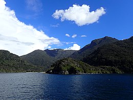
Resolution from the North - Near the
Gilbert Islands
1781:
1715:
1660:
1609:
1578:
1532:
1196:
1145:
1099:
1038:
947:
841:
810:
717:
184:
179:
163:
155:
147:
139:
129:
92:
87:
33:
577:"Endangered saddleback find new home in Fiordland"
452:Index of Māori Names: Tarepa to Tawake Moe Tahanga
552:"Island move gives birds better shot at survival"
242:Taumoana (Five Fingers Peninsula) Marine Reserve
257:which landed here on Dusky Sound during Cook's
299:On 15 July 2009, Resolution island was at the
694:
662:New Zealand to create more island sanctuaries
644:. Canterbury University Press: Christchurch.
8:
579:. Department of Conservation. 22 August 2017
28:
491:
489:
701:
687:
679:
45:
27:
1794:New Zealand American Fiordland Expedition
626:Hill, Susanne; & Hill, John. (1987).
69:
604:. Department of Conservation. p. 22
531:. Department of Conservation. p. 19
16:Island in New Zealand's Fiordland region
466:"More than 220 quake claims registered"
413:
143:208.87 km (80.65 sq mi)
668:Stoats cleared from Resolution Island
7:
1815:Uninhabited islands of New Zealand
1763:Te Wahipounamu World Heritage Site
628:Richard Henry of Resolution Island
247:The island is named after Captain
21:Resolution Island (disambiguation)
19:For other Resolution Islands, see
14:
1076:Taumoana (Five Finger Peninsula)
1000:Lake McKerrow / Whakatipu Waitai
376:
68:
61:
550:Neil Ratley (7 November 2013).
205:) is the largest island in the
1071:Taipari Roa (Elizabeth Island)
392:List of islands of New Zealand
1:
1091:Te Tapuwae o Hua (Long Sound)
802:Rakituma / Preservation Inlet
640:Wilson, Kerry-Jayne. (2004).
352:karearea (New Zealand falcon)
229:. The island is part of the
296:reached the island in 1900.
240:: an area protected by the
223:Te Puaitaha / Breaksea Sound
1789:Fiordland Islands programme
1086:Te Hapua (Sutherland Sound)
1081:Te Awaatu Channel (The Gut)
151:1,069 m (3507 ft)
1846:
1782:Programmes and expeditions
1066:Piopiotahi (Milford Sound)
1061:Moana Uta (Wet Jacket Arm)
504:Department of Conservation
429:Department of Conservation
305:a magnitude 7.8 earthquake
18:
1647:Puysegur Point Lighthouse
630:. John McIndoe: Dunedin.
455:Retrieved 7 October 2009.
168:
56:
44:
284:that were threatened by
1825:Fiordland National Park
1733:Fiordland National Park
1622:Manapouri Power Station
292:management failed when
231:Fiordland National Park
1056:Kutu Parera (Gaer Arm)
725:Doubtful Sound / Patea
664:BirdLife International
238:Five Fingers Peninsula
148:Highest elevation
1632:Monowai Power Station
1627:Milford Sound Airport
772:Tamatea / Dusky Sound
757:Taiari / Chalky Inlet
742:Hinenui / Nancy Sound
219:Tamatea / Dusky Sound
1820:Islands of Fiordland
209:region of southwest
1344:John o'Groats River
1132:Murchison Mountains
1051:Kahukura (Gold Arm)
737:Hāwea / Bligh Sound
110: /
30:
1830:Island restoration
1642:Port Craig tramway
1504:Wild Natives River
1479:Wairaurāhiri River
1117:Humboldt Mountains
1112:Franklin Mountains
1046:Hawea (Clio Rocks)
642:Flight of the Huia
348:tīeke (saddleback)
344:mōhua (yellowhead)
270:introduced species
156:Highest point
114:45.667°S 166.667°E
1802:
1801:
1705:Routeburn Classic
934:Resolution Island
670:Wildlifeextra.com
195:Resolution Island
192:
191:
76:Resolution Island
29:Resolution Island
1837:
1743:Hollyford Valley
1688:Kepler Challenge
1678:Hump Ridge Track
1570:Sutherland Falls
1565:Lady Alice Falls
1499:Whitewater River
1444:Stillwater River
1279:Dry Awarua River
1178:Mount Richardson
1127:Kepler Mountains
1122:Hunter Mountains
1107:Darran Mountains
939:Secretary Island
909:Elizabeth Island
869:Belle Vue Island
782:Sutherland Sound
703:
696:
689:
680:
614:
613:
611:
609:
603:
595:
589:
588:
586:
584:
573:
567:
566:
564:
562:
547:
541:
540:
538:
536:
530:
522:
516:
515:
513:
511:
501:
493:
484:
483:
481:
479:
462:
456:
447:
441:
440:
438:
436:
426:
418:
397:Lists of islands
386:
381:
380:
125:
124:
122:
121:
120:
119:-45.667; 166.667
115:
111:
108:
107:
106:
103:
72:
71:
65:
49:
31:
1845:
1844:
1840:
1839:
1838:
1836:
1835:
1834:
1805:
1804:
1803:
1798:
1777:
1758:Te Ana-au Caves
1711:
1700:Routeburn Track
1673:Hollyford Track
1656:
1652:Te Anau Airport
1605:
1574:
1528:
1334:Hollyford River
1314:Glaisnock River
1304:Forgotten River
1299:Elizabeth River
1244:Cavendish River
1192:
1158:Mount Edgecumbe
1141:
1100:Mountain ranges
1095:
1039:Marine reserves
1034:
1015:Lake Poteriteri
943:
884:Buncrana Island
874:Breaksea Island
837:
806:
713:
707:
658:
623:
621:Further reading
618:
617:
607:
605:
601:
597:
596:
592:
582:
580:
575:
574:
570:
560:
558:
549:
548:
544:
534:
532:
528:
524:
523:
519:
509:
507:
499:
495:
494:
487:
477:
475:
464:
463:
459:
450:Fletcher, H.J.
448:
444:
434:
432:
424:
420:
419:
415:
410:
382:
375:
372:
329:
313:
261:in March 1773.
227:Acheron Passage
175:
118:
116:
112:
109:
104:
101:
99:
97:
96:
83:
82:
81:
80:
79:
78:
77:
73:
52:
40:
24:
17:
12:
11:
5:
1843:
1841:
1833:
1832:
1827:
1822:
1817:
1807:
1806:
1800:
1799:
1797:
1796:
1791:
1785:
1783:
1779:
1778:
1776:
1775:
1770:
1765:
1760:
1755:
1753:Puysegur Point
1750:
1745:
1740:
1738:Foveaux Strait
1735:
1730:
1725:
1719:
1717:
1716:Other features
1713:
1712:
1710:
1709:
1708:
1707:
1697:
1692:
1691:
1690:
1680:
1675:
1670:
1664:
1662:
1661:Walking tracks
1658:
1657:
1655:
1654:
1649:
1644:
1639:
1634:
1629:
1624:
1619:
1613:
1611:
1607:
1606:
1604:
1603:
1598:
1593:
1588:
1582:
1580:
1576:
1575:
1573:
1572:
1567:
1562:
1560:Humboldt Falls
1557:
1552:
1550:Grainger Falls
1547:
1542:
1536:
1534:
1530:
1529:
1527:
1526:
1521:
1519:Windward River
1516:
1511:
1506:
1501:
1496:
1491:
1486:
1481:
1476:
1471:
1466:
1461:
1456:
1451:
1446:
1441:
1436:
1431:
1429:Seaforth River
1426:
1421:
1419:Red Pyke River
1416:
1411:
1406:
1401:
1396:
1391:
1386:
1381:
1376:
1371:
1366:
1361:
1356:
1351:
1346:
1341:
1336:
1331:
1329:Gulliver River
1326:
1321:
1316:
1311:
1306:
1301:
1296:
1294:Electric River
1291:
1289:Eglinton River
1286:
1281:
1276:
1271:
1266:
1261:
1256:
1251:
1246:
1241:
1236:
1231:
1226:
1221:
1216:
1211:
1206:
1200:
1198:
1194:
1193:
1191:
1190:
1185:
1180:
1175:
1170:
1165:
1160:
1155:
1149:
1147:
1143:
1142:
1140:
1139:
1137:Wick Mountains
1134:
1129:
1124:
1119:
1114:
1109:
1103:
1101:
1097:
1096:
1094:
1093:
1088:
1083:
1078:
1073:
1068:
1063:
1058:
1053:
1048:
1042:
1040:
1036:
1035:
1033:
1032:
1027:
1022:
1017:
1012:
1007:
1002:
997:
992:
990:Lake Manapouri
987:
982:
977:
972:
967:
962:
957:
955:Lake Alabaster
951:
949:
945:
944:
942:
941:
936:
931:
926:
921:
916:
911:
906:
901:
896:
891:
886:
881:
876:
871:
866:
861:
856:
851:
845:
843:
839:
838:
836:
835:
830:
825:
820:
814:
812:
808:
807:
805:
804:
799:
794:
792:Breaksea Sound
789:
784:
779:
777:Thompson Sound
774:
769:
764:
759:
754:
749:
747:Bradshaw Sound
744:
739:
734:
733:
732:
721:
719:
715:
714:
708:
706:
705:
698:
691:
683:
677:
676:
671:
665:
657:
656:External links
654:
653:
652:
638:
622:
619:
616:
615:
590:
568:
542:
517:
485:
474:. 16 July 2009
457:
442:
412:
411:
409:
406:
405:
404:
399:
394:
388:
387:
384:Islands portal
371:
368:
328:
325:
312:
309:
190:
189:
186:
182:
181:
177:
176:
169:
166:
165:
164:Administration
161:
160:
157:
153:
152:
149:
145:
144:
141:
137:
136:
131:
127:
126:
94:
90:
89:
85:
84:
75:
74:
67:
66:
60:
59:
58:
57:
54:
53:
50:
42:
41:
34:
15:
13:
10:
9:
6:
4:
3:
2:
1842:
1831:
1828:
1826:
1823:
1821:
1818:
1816:
1813:
1812:
1810:
1795:
1792:
1790:
1787:
1786:
1784:
1780:
1774:
1771:
1769:
1766:
1764:
1761:
1759:
1756:
1754:
1751:
1749:
1748:McKinnon Pass
1746:
1744:
1741:
1739:
1736:
1734:
1731:
1729:
1726:
1724:
1721:
1720:
1718:
1714:
1706:
1703:
1702:
1701:
1698:
1696:
1695:Milford Track
1693:
1689:
1686:
1685:
1684:
1681:
1679:
1676:
1674:
1671:
1669:
1666:
1665:
1663:
1659:
1653:
1650:
1648:
1645:
1643:
1640:
1638:
1635:
1633:
1630:
1628:
1625:
1623:
1620:
1618:
1615:
1614:
1612:
1608:
1602:
1599:
1597:
1594:
1592:
1591:Milford Sound
1589:
1587:
1584:
1583:
1581:
1577:
1571:
1568:
1566:
1563:
1561:
1558:
1556:
1553:
1551:
1548:
1546:
1543:
1541:
1538:
1537:
1535:
1531:
1525:
1522:
1520:
1517:
1515:
1512:
1510:
1507:
1505:
1502:
1500:
1497:
1495:
1492:
1490:
1487:
1485:
1484:Waitutu River
1482:
1480:
1477:
1475:
1474:Waikōau River
1472:
1470:
1467:
1465:
1462:
1460:
1459:Transit River
1457:
1455:
1452:
1450:
1447:
1445:
1442:
1440:
1437:
1435:
1432:
1430:
1427:
1425:
1422:
1420:
1417:
1415:
1412:
1410:
1407:
1405:
1402:
1400:
1399:Pandora River
1397:
1395:
1394:Olivine River
1392:
1390:
1387:
1385:
1382:
1380:
1379:Monowai River
1377:
1375:
1372:
1370:
1367:
1365:
1362:
1360:
1357:
1355:
1352:
1350:
1347:
1345:
1342:
1340:
1337:
1335:
1332:
1330:
1327:
1325:
1322:
1320:
1317:
1315:
1312:
1310:
1307:
1305:
1302:
1300:
1297:
1295:
1292:
1290:
1287:
1285:
1282:
1280:
1277:
1275:
1272:
1270:
1267:
1265:
1262:
1260:
1257:
1255:
1254:Clinton River
1252:
1250:
1249:Cleddau River
1247:
1245:
1242:
1240:
1237:
1235:
1234:Carrick River
1232:
1230:
1229:Camelot River
1227:
1225:
1222:
1220:
1217:
1215:
1212:
1210:
1207:
1205:
1202:
1201:
1199:
1195:
1189:
1186:
1184:
1183:Mount Titiroa
1181:
1179:
1176:
1174:
1173:Mount Moturau
1171:
1169:
1168:Mount Luxmore
1166:
1164:
1161:
1159:
1156:
1154:
1151:
1150:
1148:
1144:
1138:
1135:
1133:
1130:
1128:
1125:
1123:
1120:
1118:
1115:
1113:
1110:
1108:
1105:
1104:
1102:
1098:
1092:
1089:
1087:
1084:
1082:
1079:
1077:
1074:
1072:
1069:
1067:
1064:
1062:
1059:
1057:
1054:
1052:
1049:
1047:
1044:
1043:
1041:
1037:
1031:
1030:Waiuna Lagoon
1028:
1026:
1023:
1021:
1018:
1016:
1013:
1011:
1008:
1006:
1003:
1001:
998:
996:
993:
991:
988:
986:
983:
981:
978:
976:
973:
971:
968:
966:
963:
961:
958:
956:
953:
952:
950:
946:
940:
937:
935:
932:
930:
929:Pomona Island
927:
925:
922:
920:
919:Indian Island
917:
915:
912:
910:
907:
905:
904:Cooper Island
902:
900:
897:
895:
894:Chalky Island
892:
890:
889:Centre Island
887:
885:
882:
880:
877:
875:
872:
870:
867:
865:
862:
860:
857:
855:
852:
850:
849:Anchor Island
847:
846:
844:
840:
834:
833:Te Waewae Bay
831:
829:
828:Pearl Harbour
826:
824:
821:
819:
816:
815:
813:
809:
803:
800:
798:
795:
793:
790:
788:
785:
783:
780:
778:
775:
773:
770:
768:
767:Caswell Sound
765:
763:
762:Charles Sound
760:
758:
755:
753:
752:Milford Sound
750:
748:
745:
743:
740:
738:
735:
731:
728:
727:
726:
723:
722:
720:
716:
712:, New Zealand
711:
704:
699:
697:
692:
690:
685:
684:
681:
675:
672:
669:
666:
663:
660:
659:
655:
651:
650:0-908812-52-3
647:
643:
639:
637:
636:0-86868-094-X
633:
629:
625:
624:
620:
600:
594:
591:
578:
572:
569:
557:
553:
546:
543:
527:
521:
518:
505:
498:
492:
490:
486:
473:
472:
467:
461:
458:
454:
453:
446:
443:
430:
423:
417:
414:
407:
403:
402:Desert island
400:
398:
395:
393:
390:
389:
385:
379:
374:
369:
367:
365:
361:
357:
353:
349:
345:
341:
338:
334:
326:
324:
322:
318:
310:
308:
306:
302:
297:
295:
291:
287:
283:
279:
275:
274:Richard Henry
271:
267:
262:
260:
259:Second Voyage
256:
255:
250:
245:
243:
239:
234:
232:
228:
224:
220:
216:
212:
208:
204:
200:
196:
187:
183:
178:
174:
173:
167:
162:
158:
154:
150:
146:
142:
138:
135:
132:
128:
123:
95:
91:
86:
64:
55:
48:
43:
38:
32:
26:
22:
1728:Awarua Point
1683:Kepler Track
1637:Milford Road
1617:Homer Tunnel
1555:Helena Falls
1545:Browne Falls
1514:Wilson River
1509:Wilmot River
1494:Wapiti River
1489:Walker River
1464:Tūtoko River
1454:Thurso River
1449:Talbot River
1424:Rooney River
1389:Newton River
1309:George River
1239:Castle River
1214:Awarua River
1209:Arthur River
1188:Mount Tūtoko
1025:Lake Te Anau
1010:Lake Monowai
1005:Mirror Lakes
980:Lake Hauroko
933:
914:Great Island
859:Bauza Island
854:Arran Island
787:George Sound
641:
627:
606:. Retrieved
593:
581:. Retrieved
571:
559:. Retrieved
545:
533:. Retrieved
520:
508:. Retrieved
476:. Retrieved
469:
460:
451:
445:
433:. Retrieved
431:. p. 20
416:
330:
314:
298:
290:conservation
263:
253:
246:
237:
235:
215:South Island
198:
194:
193:
180:Demographics
170:
159:Mount Clerke
25:
1773:Wilmot Pass
1723:Aurora Cave
1668:Dusky Track
1579:Settlements
1540:Bowen Falls
1524:Wolff River
1469:Waiau River
1374:Misty River
1364:Lyvia River
1359:Light River
1354:Kaipo River
1339:Irene River
1324:Grebe River
1284:Edith River
1269:Donne River
1224:Bowen River
1163:Mount Grono
995:Lake Marian
965:Lake Fergus
924:Long Island
899:Coal Island
823:Martins Bay
583:4 September
561:4 September
556:Stuff.co.nz
506:. p. 2
471:Stuff.co.nz
211:New Zealand
172:New Zealand
134:New Zealand
130:Archipelago
117: /
93:Coordinates
35:Tau Moana (
1809:Categories
1610:Structures
1596:Port Craig
1533:Waterfalls
1439:Spey River
1434:Shag River
1409:Pyke River
1404:Pitt River
1384:Namu River
1369:Mike River
1349:Juno River
1319:Gray River
1274:Doon River
1264:Dark River
1259:Coal River
1153:Mitre Peak
1020:Lake Quill
985:Lake Innes
975:Green Lake
960:Lake Alice
797:Dagg Sound
608:13 October
535:13 October
510:13 October
478:5 November
435:17 October
408:References
337:Goodnature
333:since 2008
254:Resolution
249:James Cook
185:Population
1768:West Cape
1586:Manapouri
1414:Rea River
1219:Big River
1204:Aan River
1146:Mountains
970:Lake Gunn
879:Brig Rock
730:Deep Cove
710:Fiordland
340:A24 traps
321:mistletoe
301:epicentre
286:mustelids
207:Fiordland
199:Tau Moana
88:Geography
864:Bay Rock
370:See also
251:'s ship
105:166°40′E
1601:Te Anau
842:Islands
818:Big Bay
317:possums
266:cleared
102:45°40′S
1197:Rivers
718:Fiords
648:
634:
362:, and
294:stoats
278:kākāpō
225:, and
948:Lakes
602:(PDF)
529:(PDF)
500:(PDF)
425:(PDF)
327:Fauna
311:Flora
203:Māori
37:Māori
811:Bays
646:ISBN
632:ISBN
610:2017
585:2017
563:2017
537:2017
512:2017
480:2011
437:2017
364:kiwi
356:kaka
346:and
282:kiwi
280:and
140:Area
360:kea
303:of
268:of
217:by
197:or
1811::
554:.
502:.
488:^
468:.
427:.
366:.
358:,
354:,
307:.
244:.
233:.
221:,
702:e
695:t
688:v
612:.
587:.
565:.
539:.
514:.
482:.
439:.
201:(
188:0
39:)
23:.
Text is available under the Creative Commons Attribution-ShareAlike License. Additional terms may apply.