42:
650:
89:
371:. The first land sold was to John Bruckner at $ 8 an acre. John bought around 160 acres, but had 8,000 acres to choose from. The land he chose sits near the corner of FM 267 and CR 4260. The Rhineland Common School District was organized in 1898, with the first schoolhouse being built the following year. A larger, brick school building was constructed in 1926 that provided public education through high school. A number of students attended a local parochial school.
159:
59:
177:
96:
66:
374:
By 1950, Rhineland had around 75 residents. Over the years, the community experienced a slight rise in population, but the number of businesses declined. Rhineland's school district later consolidated with nearby Munday. In 1980, the estimated number of inhabitants in
Rhineland was 196. That figure
362:
The community was officially established on
February 1, 1895, when the land contract between J.C. League and German-born Catholics – Father Joseph R. Reisdorff and Hugh Herchenbach – was notarized. The 12,000-acre (49 km) plot was advertised as a colony for German Catholics and was named after
747:
524:
384:
322:
at the intersection of Farm-to-Market roads 267 and 2534 in southeastern Knox County. It is situated 9 mi (14 km) to the southeast of the county seat of
742:
578:
458:
41:
318:
Rhineland is located within the physiographic region known as the Texas
Rolling Plains, approximately 1 mi (1.6 km) south of the
449:
121:
402:
571:
343:
247:
454:
564:
556:
88:
397:
32:
539:
444:
481:
58:
719:
712:
407:
679:
297:
588:
301:
192:
549:
306:
283:
503:
669:
347:
694:
629:
610:
323:
544:
477:
278:
331:
736:
639:
327:
268:
164:
634:
412:
319:
202:
699:
603:
423:
136:
123:
540:
U.S. Geological Survey
Geographic Names Information System: Rhineland, Texas
364:
238:
368:
417:
383:
Public education in the community of
Rhineland is provided by the
243:
182:
661:
621:
560:
648:
310:, the community had an estimated population of 100 in 2000.
678:
660:
620:
274:
264:
254:
237:
229:
224:
216:
208:
198:
188:
170:
152:
23:
748:Unincorporated communities in Knox County, Texas
472:
470:
468:
18:Unincorporated community in Texas, United States
385:Munday Consolidated Independent School District
572:
8:
579:
565:
557:
20:
459:United States Department of the Interior
330:, and 85 mi (137 km) north of
649:
436:
273:
253:
236:
223:
215:
207:
151:
116:
50:
38:
263:
228:
197:
187:
169:
7:
525:Climate Summary for Rhineland, Texas
743:Unincorporated communities in Texas
450:Geographic Names Information System
326:, 6 mi (9.7 km) north of
587:Municipalities and communities of
304:, United States. According to the
14:
403:Double Mountain Fork Brazos River
95:
65:
175:
157:
94:
87:
64:
57:
40:
506:. Texas Escapes Online Magazine
455:United States Geological Survey
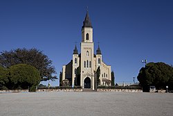
46:St Joseph's Church in Rhineland
1:
344:Köppen climate classification
108:Show map of the United States
375:had fallen to 100 by 2000.
764:
220:1,404 ft (428 m)
708:
646:
601:
117:
51:
39:
30:
398:Double Mountains (Texas)
298:unincorporated community
33:Unincorporated community
654:
652:
482:The Handbook of Texas
346:, Rhineland enjoys a
137:33.52972°N 99.65500°W
721:United States portal
408:List of Texas rivers
142:33.52972; -99.65500
133: /
655:
590:Knox County, Texas
504:"Rhineland, Texas"
478:"Rhineland, Texas"
420:(river of Germany)
302:Knox County, Texas
230: • Total
203:Brazos River basin
730:
729:
550:Handbook of Texas
354:on climate maps.
342:According to the
307:Handbook of Texas
291:
290:
284:Handbook of Texas
78:Show map of Texas
755:
722:
715:
651:
613:
606:
596:
591:
581:
574:
567:
558:
545:Rhineland, Texas
527:
522:
516:
515:
513:
511:
500:
494:
493:
491:
489:
474:
463:
462:
441:
348:semiarid climate
279:Rhineland, Texas
181:
179:
178:
163:
161:
160:
148:
147:
145:
144:
143:
138:
134:
131:
130:
129:
126:
109:
98:
97:
91:
79:
68:
67:
61:
44:
25:Rhineland, Texas
21:
763:
762:
758:
757:
756:
754:
753:
752:
733:
732:
731:
726:
720:
713:
704:
681:
674:
656:
653:Knox County map
644:
616:
611:
604:
597:
594:
589:
585:
536:
531:
530:
523:
519:
509:
507:
502:
501:
497:
487:
485:
476:
475:
466:
443:
442:
438:
433:
428:
393:
381:
360:
340:
316:
260:
176:
174:
158:
156:
141:
139:
135:
132:
127:
124:
122:
120:
119:
113:
112:
111:
110:
107:
106:
105:
104:
103:
99:
82:
81:
80:
77:
76:
75:
74:
73:
69:
47:
35:
26:
19:
12:
11:
5:
761:
759:
751:
750:
745:
735:
734:
728:
727:
725:
724:
717:
709:
706:
705:
703:
702:
697:
692:
686:
684:
680:Unincorporated
676:
675:
673:
672:
666:
664:
658:
657:
647:
645:
643:
642:
637:
632:
626:
624:
618:
617:
602:
599:
598:
586:
584:
583:
576:
569:
561:
555:
554:
542:
535:
534:External links
532:
529:
528:
517:
495:
464:
435:
434:
432:
429:
427:
426:
421:
415:
410:
405:
400:
394:
392:
389:
380:
377:
359:
356:
339:
336:
315:
312:
289:
288:
276:
272:
271:
266:
262:
261:
258:
256:
252:
251:
241:
235:
234:
231:
227:
226:
222:
221:
218:
214:
213:
210:
206:
205:
200:
196:
195:
190:
186:
185:
172:
168:
167:
154:
150:
149:
115:
114:
101:
100:
93:
92:
86:
85:
84:
83:
71:
70:
63:
62:
56:
55:
54:
53:
52:
49:
48:
45:
37:
36:
31:
28:
27:
24:
17:
13:
10:
9:
6:
4:
3:
2:
760:
749:
746:
744:
741:
740:
738:
723:
718:
716:
711:
710:
707:
701:
698:
696:
693:
691:
688:
687:
685:
683:
677:
671:
668:
667:
665:
663:
659:
641:
638:
636:
633:
631:
628:
627:
625:
623:
619:
615:
614:
607:
600:
595:United States
592:
582:
577:
575:
570:
568:
563:
562:
559:
553:
551:
546:
543:
541:
538:
537:
533:
526:
521:
518:
505:
499:
496:
483:
479:
473:
471:
469:
465:
460:
456:
452:
451:
446:
440:
437:
430:
425:
422:
419:
416:
414:
411:
409:
406:
404:
401:
399:
396:
395:
390:
388:
386:
378:
376:
372:
370:
366:
357:
355:
353:
349:
345:
337:
335:
333:
329:
325:
321:
313:
311:
309:
308:
303:
299:
295:
287:
285:
280:
277:
270:
267:
257:
249:
245:
242:
240:
232:
219:
211:
204:
201:
194:
191:
184:
173:
166:
165:United States
155:
146:
118:Coordinates:
90:
60:
43:
34:
29:
22:
16:
714:Texas portal
689:
609:
548:
520:
508:. Retrieved
498:
486:. Retrieved
448:
439:
413:Saint Joseph
382:
373:
361:
351:
341:
320:Brazos River
317:
305:
293:
292:
282:
15:
682:communities
605:County seat
445:"Rhineland"
209:Established
140: /
737:Categories
510:August 21,
488:August 21,
431:References
424:West Texas
367:region in
225:Population
128:99°39′18″W
125:33°31′47″N
690:Rhineland
670:Knox City
547:from the
379:Education
365:Rhineland
314:Geography
294:Rhineland
281:from the
265:Area code
239:Time zone
217:Elevation
102:Rhineland
72:Rhineland
695:Truscott
630:Benjamin
612:Benjamin
391:See also
324:Benjamin
255:ZIP code
369:Germany
358:History
338:Climate
332:Abilene
275:Website
153:Country
640:Munday
622:Cities
552:Online
484:online
328:Munday
296:is an
286:Online
199:Region
189:County
180:
162:
635:Goree
418:Rhine
259:76371
244:UTC-6
183:Texas
171:State
700:Vera
662:Town
512:2009
490:2009
363:the
212:1895
193:Knox
352:BSk
300:in
269:940
248:CST
233:100
739::
608::
593:,
480:.
467:^
457:,
453:.
447:.
387:.
350:,
334:.
580:e
573:t
566:v
514:.
492:.
461:.
250:)
246:(
Text is available under the Creative Commons Attribution-ShareAlike License. Additional terms may apply.