202:
194:
376:
36:
416:, which caused ten deaths in Nashville's Davidson County. In the aftermath, Metro Government acquired 61 flood-damaged homes in the Delray Drive area along the course of Richland Creek. The homes were torn down to develop England Park— a green space which helps absorb excess water from Richland Creek during any future flooding. The name, "England Park" was in honor of Martha and Andy England who drowned in their home in the flood of 2010. The project was financed by federal and state funding along with stormwater fees paid by residents in every part of the city.
275:. Its source is in west Nashville and consists of the confluence of at least eight streams. One is near Tyne Boulevard at Fredericksburg Drive and mostly follows Tyne northwest toward Belle Meade Boulevard. There it is joined by a Chickering Branch arising near Chickering Lane and flowing along the east side of Chickering Road. After crossing under Belle Meade Boulevard, Richland Creek is joined by its Belle Meade Branch (which flows roughly parallel to Harding Place west of Hillsboro Road) then winds through the golf course of Belle Meade Country Club.
395:. This includes two above-ground tanks large enough to temporarily hold 31 million gallons of liquid when sewer flow exceeds the capacity of the treatment plant. The tanks, called "equalization facilities", hold the sewage until the stormwater recedes, then send the sewage to the treatment plant at an optimal processing rate. The project is aided by a wet-weather pump that can handle 45 million gallons per day. The West Park Project was dedicated by Mayor
336:, the group was said to be serving the public interest free of political influence or financial support. The committee reported massive pollution in Richland Creek by raw sewage from the Metro Government sewer system, as well as by bacteria and industrial wastes from the drainage ditches which flow into the creek.
348:
The impairment of
Richland Creek is by several contaminants, primarily stormwater runoff which flushes pollutants into Richland Creek during heavy rainstorms. Ideally, sewage and stormwater should be kept separate. When defects allow rainwater or surface water to find its way into the sewer system it
344:
As of 2016, there continues to be a public health and safety contact advisory placed on
Richland Creek because of chronic sewer issues– it is on The Tennessee Department of Environment and Conservation (TDEC) 303(d) "List of Impaired Waterbodies". The U.S. Congress mandated that all states develop a
360:
on school property adjacent to West End Avenue. During the drilling process, sewage surfaced where the work was being done. It was determined that when remodeling a neighboring fire station, the sewer lines were mistakenly routed to an abandoned storm sewer instead of the sanitary sewer. The sewage
310:
in a northerly path along White Bridge Road. It picks up the Bosley
Springs Branch and the Murphy Road Branch and flows near Briley Parkway past England Park and West Park to reach the Cumberland River at the end of Robertson Avenue. The more industrialized area of Richland Creek is at its northwest
403:
Richland Creek
Watershed Alliance, organized in 2007, is a conservation group to preserve the long term environmental stability of the watershed and has been an advocate of the creek on numerous occasions. As of 2016, the organization has engaged volunteers in removing 51 tons of trash and planted
383:
In 2009, a
Consent Decree between the US Government, the State of Tennessee, and the Metropolitan Government of Nashville and Davidson County was entered with the US District Court for the Middle District of Tennessee. It was filed on behalf of the US Environmental Protection Agency (EPA) and the
329:
In 1970, complains of pollution in
Richland Creek prompted an independent scientific study by a group of several university professors called "The Nashville Committee for Scientific Information". The study found that Richland Creek was being polluted not only by private industries but also by the
319:
In 1936, millions of dead fish appeared in the
Cumberland River near the mouth of Richland Creek. This was believed to be from pollution by the discharging of poisonous dyestuffs into Richland Creek by factories nearby. In 1946, the city of Nashville commissioned an engineering report which found
301:
and crosses under
Harding Road (Highway 70 South) near the intersection of Belle Meade Boulevard. It merges with Sugartree Creek (which roughly follows Woodmont Boulevard) near the intersection of Harding Road and White Bridge Road. From this point, Richland Creek meanders behind
399:
on August 18, 2018, and its site includes recreational facilities including a lighted softball field, basketball court, picnic area, a pavilion with public rest rooms and other amenities. Artist Eric Henn created a mural on the tank to add public art to the neighborhood.
345:
Source Water
Assessment Program in the "1966 Safe Drinking Water Act". Tennessee's program was approved by the EPA in 1999. The state produces a document every two years on the status of water quality, known as the 305(b) Report.
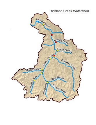
205:
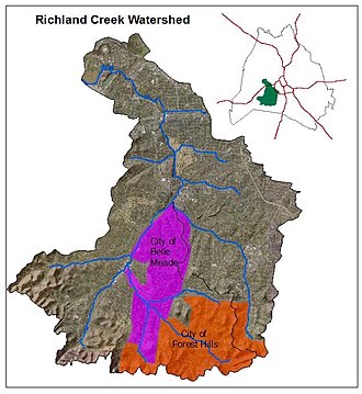
Richland Creek
Watershed, Nashville, Tennessee showing suburban cities Belle Meade and Forest Hills. Top right: Davidson County outline with Nashville in center. Green insert is the watershed, about 4 miles west of
214:
consists of 17,712 acres (27.675 sq mi) within the city of Nashville, approximately 4 miles west of downtown. The Richland Creek watershed includes at least eight tributaries, not all of which are named:
595:
197:
Richland Creek Watershed (Nashville, Tennessee) with tributaries. The creek's source is at the bottom of the map (south); its mouth is into the Cumberland River at top left (northwest).
384:
Tennessee Department of Environment and Conservation (TDEC). It included correction of sanitary sewer overflows, not just at Richland Creek but at several other sites in the city.
311:
course near where it flows into the Cumberland River. As of 2016, this area included a rock quarry, a concrete mixing facility and several large petroleum bulk storage terminals.
201:
801:
867:
294:
99:
1053:
185:
near Rock Harbor Marina at the end of Robertson Avenue. This is one of at least five streams by the name of "Richland Creek" in various regions of Tennessee.
1068:
1058:
244:
Richland Creek has an approximate elevation of 390 feet (120 m). Its mouth is a south branch of the Cumberland River shown at these coordinates:
193:
247:
605:. Metropolitan Government of Nashville & Davidson County (Prepared by Metro Water Services Stormwater Division). December 20, 2016. p. 1
349:
decreases the capacity of the sewer to perform efficiently. This ultimately causes breaches and overflows into nearby creeks and tributaries.
775:
499:
Click on these coordinates to see a map showing the mouth of Richland Creek at the Cumberland River. You can zoom the map for more detail.
375:
35:
525:
994:
705:
1063:
17:
946:
320:
inadequate sewage disposal and recommended a sewage treatment plant and a new system of intercepting sewers. That year the
924:
1048:
303:
479:
441:
307:
279:
472:
170:
54:
361:
was sent underground to the groundwater where it entered the Richland Creek near the Bosley Springs branch. The
835:
1016:
453:
445:
353:
178:
624:
540:
434:
430:
283:
174:
413:
968:
464:
357:
166:
468:
898:
449:
298:
367:
values dropped at that site after the repair was made, but this was far from a complete answer.
379:
Wastewater equalization tank, West Park, Nashville,Tennessee. Pumping station to left of tank
388:
182:
85:
426:
392:
708:. Vol. 40, no. 154. The Tennessean (Nashville). October 13, 1948. p. 13–A
332:
322:
211:
756:. Vol. 64, no. 293. The Nashville Tennessean. February 15, 1970. p. 4–B
326:
stated, "the lower reaches of Richland Creek can be considered only as a open sewer".
1042:
893:
460:
58:
681:"Millions of Dead Fish In Cumberland Cause Probe of Pollution Below Richland Creek"
396:
811:. Tennessee Department of Environment and Conservation Division of Water Resources
653:
290:
subdivision) at a point near the intersection of Leake Avenue and Harding Road.
70:
868:"Mayor David Briley, Metro Officials Reopen West Park After Major Improvements"
753:
728:
680:
562:
287:
997:. Vol. 26, no. 52. The Fairview Observer. June 2, 2015. p. A–9
565:. Vol. 64, no. 293. The Tennessean. February 15, 1970. p. 17–A
262:
249:
114:
101:
456:
and into the Tennessee River below the border between Tennessee and Alabama.
330:
sewer system of Nashville's Metropolitan Government. In an editorial by the
949:. Vol. 105, no. 38. The Dickson Herald. May 11, 2012. p. 3–A
802:"Protection of Potable Water Supplies in Tennessee Watersheds: 2017 Report"
543:. Vol. 106, no. 94. The Tennessean. July 13, 2010. p. 8–A
995:"Six Tennessee sites added to the National Register of Historic Places"
927:. Vol. 111, no. 151. The Tennessean (Nashville). p. 17–A
363:
173:. It winds for 28 miles (45 km) through the Nashville suburbs of
162:
842:. Metro Water Services of Nashville and Davidson County, Tennessee
374:
200:
192:
731:. Vol. 64, no. 293. The Nashville Tennessean. p. 1
683:. Vol. 30, no. 660. The Nashville Tennessean. p. 1
286:, then receives the Jocelyn Hollow Branch (which flows from the
782:. Tennessee Department of Environment and Conservation (TDEC)
219:
Jocelyn Hollow Branch (roughly follows Jocelyn Hollow Road)
830:
828:
826:
412:
Richland Creek was involved in severe flooding in the
527:
The Tennessee Gazetteer, Or Topographical Dictionary
40:
Richland Creek near Belle Meade Boulevard, Nashville
563:"West Nashville Study: Full Stream Report Released"
148:
140:
130:
91:
79:
69:
64:
50:
45:
28:
918:
916:
1017:"Big Richland Creek Topo Map in Humphreys County"
861:
859:
857:
648:
646:
748:
746:
700:
698:
234:Bosley Springs Branch (near St. Thomas Hospital)
754:"Pollution Study Group Serving Public Interest"
590:
588:
586:
584:
582:
580:
478:An eastern tributary of the Tennessee River in
925:"Flood protection system is right thing to do"
892:Harless, William; Robbins, Liz (May 4, 2010).
631:. Scottsboro USGS quad topo map: Locality, LLC
520:
518:
516:
8:
541:"Public needs answers about Richland impact"
387:Construction began in 2009 on the West Park
231:Sugartree Creek (follows Woodmont Boulevard)
969:"Richland Creek Topo Map in Rhea County TN"
836:"West Park Equalization Facility, Phase II"
596:"Richland Creek Watershed Management Plan"
278:The creek adds a Vaughn's Gap Branch near
228:Belle Meade Branch (follows Harding Place)
222:Vaughn's Gap Branch (follows Harding Pike)
225:Chickering Branch (along Chickering Road)
706:"Outmoded Sewerage Creates City Problem"
404:over 1700 trees along stream corridors.
530:, W.H. Hunt & Company, 1834, p. 139
512:
492:
237:Murphy Road Branch (along Murphy Road)
25:
894:"River Begins to Recede in Tennessee"
152:17,712 acres (27.675 sq mi)
7:
1054:Rivers of Davidson County, Tennessee
420:Other "Richland Creeks" in Tennessee
1069:Tributaries of the Cumberland River
727:Ritter, Frank (February 15, 1970).
482:, about 70 miles west of Nashville.
14:
1059:Geography of Nashville, Tennessee
660:. U.S. Department of the Interior
448:(south of Nashville), flowing by
23:River in Tennessee, United States
34:
679:Lipscomb, John (July 7, 1936).
315:History of environmental issues
293:Richland Creek then flows past
240:and smaller unnamed tributaries
463:, about 20 miles northeast of
181:and eventually flows into the
93: • coordinates
1:
65:Physical characteristics
729:"Metro Blamed for Pollution"
625:"Richland Creek Information"
340:Current environmental status
132: • elevation
923:Dean, Karl (May 31, 2015).
81: • location
1085:
295:Congregation Ohabai Sholom
55:Davidson County, Tennessee
15:
776:"Source Water Assessment"
467:, flowing by the town of
459:A northern branch of the
263:36.1642237°N 86.8883339°W
33:
654:"U.S. Geological Survey"
840:cleanwaternashville.org
358:geothermal installation
354:Montgomery Bell Academy
268:36.1642237; -86.8883339
165:in the western part of
1064:Belle Meade, Tennessee
380:
297:, picks up some small
284:Belle Meade Plantation
207:
198:
414:2010 Tennessee floods
378:
204:
196:
144:28 miles (45 km)
136:390 feet (120 m)
947:"England Park Built"
167:Nashville, Tennessee
16:For other uses, see
1049:Rivers of Tennessee
425:A tributary of the
304:St. Thomas Hospital
282:and continues past
259: /
210:The Richland Creek
115:36.1641°N 86.8880°W
111: /
899:The New York Times
389:Equalization Basin
381:
208:
199:
371:Improvements made
156:
155:
120:36.1641; -86.8880
1076:
1033:
1032:
1030:
1028:
1013:
1007:
1006:
1004:
1002:
991:
985:
984:
982:
980:
965:
959:
958:
956:
954:
943:
937:
936:
934:
932:
920:
911:
910:
908:
906:
889:
883:
882:
880:
878:
863:
852:
851:
849:
847:
832:
821:
820:
818:
816:
806:
798:
792:
791:
789:
787:
772:
766:
765:
763:
761:
750:
741:
740:
738:
736:
724:
718:
717:
715:
713:
702:
693:
692:
690:
688:
676:
670:
669:
667:
665:
650:
641:
640:
638:
636:
621:
615:
614:
612:
610:
600:
592:
575:
574:
572:
570:
559:
553:
552:
550:
548:
537:
531:
522:
500:
497:
480:Humphreys County
440:A branch of the
391:and Wet Weather
356:began work on a
274:
273:
271:
270:
269:
264:
260:
257:
256:
255:
252:
183:Cumberland River
126:
125:
123:
122:
121:
116:
112:
109:
108:
107:
104:
86:Cumberland River
38:
26:
1084:
1083:
1079:
1078:
1077:
1075:
1074:
1073:
1039:
1038:
1037:
1036:
1026:
1024:
1023:. Locality, LLC
1015:
1014:
1010:
1000:
998:
993:
992:
988:
978:
976:
975:. Locality, LLC
967:
966:
962:
952:
950:
945:
944:
940:
930:
928:
922:
921:
914:
904:
902:
891:
890:
886:
876:
874:
865:
864:
855:
845:
843:
834:
833:
824:
814:
812:
804:
800:
799:
795:
785:
783:
774:
773:
769:
759:
757:
752:
751:
744:
734:
732:
726:
725:
721:
711:
709:
704:
703:
696:
686:
684:
678:
677:
673:
663:
661:
652:
651:
644:
634:
632:
623:
622:
618:
608:
606:
598:
594:
593:
578:
568:
566:
561:
560:
556:
546:
544:
539:
538:
534:
524:Eastin Morris,
523:
514:
509:
504:
503:
498:
494:
489:
473:Grainger County
427:Tennessee River
422:
410:
373:
342:
317:
308:Aquinas College
280:Harding Academy
267:
265:
261:
258:
253:
250:
248:
246:
245:
191:
171:Davidson County
133:
119:
117:
113:
110:
105:
102:
100:
98:
97:
94:
82:
41:
24:
21:
12:
11:
5:
1082:
1080:
1072:
1071:
1066:
1061:
1056:
1051:
1041:
1040:
1035:
1034:
1008:
986:
960:
938:
912:
884:
866:Byrd, Judith.
853:
822:
793:
767:
742:
719:
694:
671:
642:
616:
576:
554:
532:
511:
510:
508:
505:
502:
501:
491:
490:
488:
485:
484:
483:
476:
457:
438:
433:(northeast of
421:
418:
409:
406:
372:
369:
341:
338:
316:
313:
242:
241:
238:
235:
232:
229:
226:
223:
220:
190:
187:
159:Richland Creek
154:
153:
150:
146:
145:
142:
138:
137:
134:
131:
128:
127:
95:
92:
89:
88:
83:
80:
77:
76:
73:
67:
66:
62:
61:
52:
48:
47:
43:
42:
39:
31:
30:
29:Richland Creek
22:
18:Richland Creek
13:
10:
9:
6:
4:
3:
2:
1081:
1070:
1067:
1065:
1062:
1060:
1057:
1055:
1052:
1050:
1047:
1046:
1044:
1022:
1018:
1012:
1009:
996:
990:
987:
974:
970:
964:
961:
948:
942:
939:
926:
919:
917:
913:
901:
900:
895:
888:
885:
873:
872:nashville.gov
869:
862:
860:
858:
854:
841:
837:
831:
829:
827:
823:
810:
803:
797:
794:
781:
777:
771:
768:
755:
749:
747:
743:
730:
723:
720:
707:
701:
699:
695:
682:
675:
672:
659:
655:
649:
647:
643:
630:
626:
620:
617:
604:
603:nashville.gov
597:
591:
589:
587:
585:
583:
581:
577:
564:
558:
555:
542:
536:
533:
529:
528:
521:
519:
517:
513:
506:
496:
493:
486:
481:
477:
474:
470:
466:
462:
461:Holston River
458:
455:
451:
447:
443:
439:
436:
432:
428:
424:
423:
419:
417:
415:
407:
405:
401:
398:
394:
390:
385:
377:
370:
368:
366:
365:
359:
355:
350:
346:
339:
337:
335:
334:
327:
325:
324:
314:
312:
309:
305:
300:
296:
291:
289:
285:
281:
276:
272:
239:
236:
233:
230:
227:
224:
221:
218:
217:
216:
213:
203:
195:
188:
186:
184:
180:
176:
172:
168:
164:
160:
151:
147:
143:
139:
135:
129:
124:
96:
90:
87:
84:
78:
74:
72:
68:
63:
60:
59:United States
56:
53:
49:
44:
37:
32:
27:
19:
1025:. Retrieved
1021:topozone.com
1020:
1011:
999:. Retrieved
989:
977:. Retrieved
972:
963:
951:. Retrieved
941:
929:. Retrieved
903:. Retrieved
897:
887:
875:. Retrieved
871:
844:. Retrieved
839:
813:. Retrieved
808:
796:
784:. Retrieved
779:
770:
758:. Retrieved
733:. Retrieved
722:
710:. Retrieved
685:. Retrieved
674:
662:. Retrieved
657:
633:. Retrieved
629:topozone.com
628:
619:
607:. Retrieved
602:
567:. Retrieved
557:
545:. Retrieved
535:
526:
495:
454:Giles County
446:Maury County
411:
402:
397:David Briley
393:pump station
386:
382:
362:
351:
347:
343:
331:
328:
321:
318:
292:
277:
243:
209:
179:Forest Hills
158:
157:
444:arising in
435:Chattanooga
431:Rhea County
266: /
175:Belle Meade
118: /
1043:Categories
507:References
333:Tennessean
323:Tennessean
288:West Meade
254:86°53′18″W
251:36°09′51″N
149:Basin size
106:86°53′17″W
103:36°09′51″N
465:Knoxville
442:Elk River
352:In 2011,
212:Watershed
206:downtown.
189:Geography
973:Topozone
953:July 28,
877:July 28,
846:July 26,
815:July 25,
786:July 25,
712:July 26,
658:usgs.gov
609:June 24,
469:Rutledge
408:Flooding
46:Location
931:27 July
450:Pulaski
364:E. coli
299:springs
51:Country
1027:May 4,
1001:May 5,
979:May 4,
905:May 5,
809:tn.gov
780:tn.gov
760:May 2,
735:May 2,
687:May 2,
664:May 2,
635:May 6,
569:May 2,
547:May 3,
163:stream
141:Length
75:
805:(PDF)
599:(PDF)
487:Notes
169:, in
161:is a
71:Mouth
1029:2019
1003:2019
981:2019
955:2019
933:2019
907:2019
879:2019
848:2019
817:2019
788:2019
762:2019
737:2019
714:2019
689:2019
666:2019
637:2019
611:2019
571:2019
549:2019
306:and
177:and
471:in
452:in
429:in
1045::
1019:.
971:.
915:^
896:.
870:.
856:^
838:.
825:^
807:.
778:.
745:^
697:^
656:.
645:^
627:.
601:.
579:^
515:^
437:).
57:,
1031:.
1005:.
983:.
957:.
935:.
909:.
881:.
850:.
819:.
790:.
764:.
739:.
716:.
691:.
668:.
639:.
613:.
573:.
551:.
475:.
20:.
Text is available under the Creative Commons Attribution-ShareAlike License. Additional terms may apply.