392:
169:
161:
323:
443:
356:
40:
302:
227:
313:
406:
391:
476:) expressed fears that both the surrounding soil and the waters of the Rida would be contaminated and asked the City Council to analyze samples in the laboratory. The mayor announced that he had contacted SPAQUE to conduct analyses and verifications at the site, and that he would inform the members of the City Council of the results.
376:
The main river begins after the Rida receives the waters of Haren and the
Exhaure de Milmort. At this location there are marshy lands on which the only two reed beds in the municipality of Herstal have been developed . There is a remarkable pollard willow with a 3 m circumference, which has not been
413:
Downstream of Bériwa, after the Moulin Nozé, the Rida split into two. The main course was diverted through the current location of rue
Laixheau and flowed toward Place Licour. During storms, part of the stream ran in its original course, via Rue Faurieux, where the vault of the passage under an old
340:
In the traditional landscape, Ås
Fontinnes flowed through a marshy valley where watercress grew abundantly. The river exhibited an aquatic ecology suitable for watercress: clear, shallow, non-acidic, slow-flowing water. Local residents came to harvest this watercress in large quantities, which they
332:
The sources of this stream originate in a meadow, and the Ås
Fontinnes stream provides a glimpse of the original rural landscape at the heads of all adjacent valleys. In the Walloon language, Ås Fontinnes means 'by the springs.' On the valley slopes, some trees remain as remnants of an old coppice.
151:
The dominant soils in the Rida Valley are silty soils with favorable natural drainage (Ab) and silty stony soils laden with flint, gravel, or conglomerate and predominantly favorable natural drainage (Gb). The latter soils are directly related to outcrops of flint clay and, to a lesser extent, some
289:
The springs of the
Ruisseau de Haren are located on the border of Herstal and Vottem; its flow is rarely powerful enough to reach the main Rida. One source is located in a hollow road (Chemin vicinal no. 11) at the corner of Rue des Bruyères (Chemin vicinal no. 30), all under cover of hedges and
455:
Until the 1970s, there was an open landfill constructed in the valley head of the Rida Valley. This dump was abandoned and reforested, without any specific remediation measures. The Rida River passes under it via a pipe that exits at the foot of the old landfill. In April 2008, Dr. Migeotte, a
215:
This aquifer is a "high groundwater table" (much higher than the level of the adjacent river, the Meuse); with the development of coal mines, the clay aquiclude was punctured in many places, creating vertical (downward) drainage. This water was drained lower in the subsurface by galleries and
348:(xhavée) on the chalk, followed by a stream with clear water. Reduced infiltration has undoubtedly significantly decreased the flow and altered the course to dry the meadows. The watercress has also disappeared. Ås Fontinnes still retains its semi-natural landscape characteristics.
351:
Further downstream, the stream is named
Ruisseau du Bouxthay. It is still marked on IGN maps as far as the ruins of the castle with the same name. It joins the main Rida near the current location of Rue Charlemagne. Downstream of the Fontinnes, this stream flows through a
395:
Bridge under the tracks of the Liège-Tongres railroad line through which the Rida runs underground, along with footpath No. 100. The edge in blue stone in the foreground marks the spot where the Rida reappeared; later it was incorporated into a pipe
487:
The 2013 municipal structure plan aims to upgrade the sections of the Rida that are still open and bring other sections back to the surface when it feasible to do so. However, the municipality is not part of the "Meuse Aval" river contract.
187:
upstream and feeds the groundwater table of
Haspengouw. All springs are at the level of the water surface. These are formed by the geological formation of the Herve Clay. The flow of the springs was influenced by the following phenomena:
384:
railroad line near the Patar farm, there is still a wet meadow, but the water of the Rida is absorbed in a pipe that leads it to the Meuse. Here and there, traces of the Rida's course are still visible in the urban landscape.
514:
The names "Ruisseau du Ponçay" and "Ruisseau du Patar" that appear on certain administrative maps are not known in Vottem. Nor do one find these names in a list of Vottem's toponymy at the beginning of the 20th century.
333:
Until the 19th century, the villagers used to come here to cut wood on the
Platduron hill and fetch water from the spring. The spring area is where the Herve clay day emerges. Water that infiltrated through the
433:
The Rida is included in the Atlas of
Unnavigable Waterways. In this atlas, the part in Vottem is called the Ruisseau du Ponçay (third category) and the part in Herstal, Ruisseau du Patar (second category).
234:
Recently, a reactivation of springs was observed. A possible cause would be the gradual collapse of the mine galleries, preventing underground drainage and returning the water table to its original level.
273:
Just downstream, along the Rida, was the farm of Ruwet, still visible on cadastral maps in 1958, with a pond where the last farmer, Mr. Colson, exploited watercress. The pond has been filled in but wild
586:
Monjoie, A. 1974. Phénomènes de dissolution dans la zone Nord de Liège. 2ème Congrès
International de l’Association Internationale de Géologie de l’Ingénieur, III-18: 10 pp., 4 fig., Sao Paolo.
152:
fragments of Meuse's terraces. It is noteworthy that the soils in the source and marsh areas are not differentiated, likely due to the low density of boreholes (approximately one per hectare).
510:
Legends circulate in Vottem about the Rida valley; witches came there and it is also mentioned that it used to be a frivolous meeting place where people came by horse and cart from Liège.
368:
This stream drains the lower part of Milmort; it is an intermittent stream. Since the construction of the Liège-Hasselt railroad, the water flows through the side drain of the rails.
500:, with the root auble attached to the Latin albus (white), i.e. "White Stream". In Vottem in particular, Rida has a positive connotation, passed down from generation to generation:
496:
In a detailed survey of the toponymy of Vottem, recorded in archives dating back to the 13th century, the toponymy "Rida" appears most frequently. Originally, people wrote
563:
422:
Along the Rida were nine water mills. That is why the stream was once called "Rieu des Mollins." The original name of the Charlemagne farm was "Moulin du Rida."
504:
In the late 1970s, early 1980s, the magazine of the schoolchildren of the Athénée Royal de Vottem (located along the brook) was called "Le Rida Enchaîné."
456:
resident of Vottem, had soil samples analyzed around this landfill at the Malvoz Institute laboratory in Liège. It concluded that the concentrations of
388:
The Rida is taken to a place called Bériwa (in Herstal ) (Etymology: "Beau Ruisseau" (in Walloon), according to the 1841 Atlas des Chemins Vicinaux).
713:
281:
Between Vottem and Herstal, the course is visible, but channelized; at a place called Au Patar, the Rida briefly assumes its natural morphology.
640:
749:
250:
The current spring is located downstream from a former landfill. However, it produces very clear water, as evidenced by a large deposit of
937:
344:
Currently, it remains an unexpected stream and landscape in a largely urbanized environment. Upstream of the springs, we can observe a
914:"Fiches de caractérisation des masses d'eau de surface du DHI Meuse - Directive-cadre sur l'Eau en Wallonie - SPWARNE © 2003 HB"
785:
739:
473:
825:
148:
and then deepens significantly into the Meuse's side, forming terraces in the shape of a ravine leading to Herstal.
1008:
616:
168:
160:
322:
209:
986:
Smeers, R., 1984. Le Rida ... son ruisseau ... ses légendes. Herstal Actualités, n° 20 (Juin 1984), pp. 11-12
670:
Fan, Gangwei; Zhang, Dongsheng (March 2015). "Mechanisms of Aquifer Protection in Underground Coal Mining".
442:
596:
Pel, J (1960). "Observations géologiques et hydrogéologiques sur le territoire de la commune de Vottem".
469:
141:
695:
267:
359:
The underground Ruisseau du Bouxthay crosses this valley near the ruins of the castle of the same name
880:"Vottem Un simple citoyen a fait analyser des échantillons de sol : L'ancienne décharge polluée"
468:
posed a risk to human health and the environment. At the Herstal City Council in October 2008, Mayor
247:, and village children bathed there. Elementary school students came by class to fish for tadpoles.
219:
Further northwest, throughout Haspengouw, the waters of this aquifer were intercepted and pumped up.
212:
into the ground. As a result, aquifer recharge is reduced and urban runoff into the basin increases.
355:
648:
223:
All this caused a lowering of the piezometric level and the drying up of the springs of the Rida.
687:
860:
La culture des fraises au Thier-à-Liège et à Vottem (1933) - Enquête du Musée de la Vie wallonne
39:
745:
903:
Motion by Councillor Vandepaer to the Herstal Municipal Council of Thursday, October 30, 2008
1003:
679:
446:
From Rue Bois Gilles, the Rida is incorporated into the sewer network of the city of Herstal
301:
226:
133:
546:
977:
Renard, E., 1934. Toponymie de Vottem et de Rocour-lez-Liège. Liège: H. Vaillant-Carmanne.
826:"hachhach: 40ième balade-santé MPLP : les sentiers, impasses et cul-de-sac de Vottem"
786:
http://carto1.wallonie.be/documents/Par_province/Liege/Liege/HERSTAL/VOTTEM/62112A0202.TIF
425:
The slopes of the Rida valley were used for growing vegetables, especially strawberries.
617:"hachhach: 55ième balade-santé MPLP Herstal : la Bacnure, Bernalmont et Belle-vue"
479:
The stream is not included in the DHI Maas surface water mass characterization sheets.
997:
691:
334:
771:
Fraikin, J., Gérard, P., Carpay, F., Matthys, H., Noelanders, J., Donis, P., 1987.
472:
was questioned about this by all political groups. Council member Johan Vandepaer (
312:
243:
The main source of the Rida is located in Vottem. This ancient wetland was called
699:
465:
405:
67:
797:
192:
As the upstream basin developed, the waterproof surfaces were enlarged. During
879:
858:
683:
345:
275:
181:
913:
184:
105:
17:
381:
263:
205:
137:
457:
197:
145:
117:
101:
76:
55:
507:
The former name of Rue Florent Boclinville in Vottem was Rue du Rida.
113:
97:
524:
404:
390:
300:
159:
129:
109:
72:
461:
251:
201:
193:
714:"Visite dans la nappe phréatique de Hesbaye qui alimente Liège"
951:
290:
bushes (50° 41′ N, 5° 36′ E), others in Rue de la Source.
136:, so the Rida valley, like the adjacent valleys between
784:
unicipality of Vottem, plan of the Ruisseau du Ponçay
82:
66:
61:
51:
46:
32:
380:Downstream from the little bridge under the Liège-
164:Current source of the Rida in Vottem and cranière
848:Berthe au grand pied by Rémi Usseil, Paris 2014
8:
598:Annales de la Société Géologique de Belgique
278:still grows, downstream of the spring area.
819:
817:
262:in Wallonia. There is also the presence of
144:, cuts into the edge of the plateau of dry
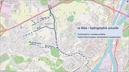
744:(in French). Presses inter Polytechnique.
973:
971:
270:are quite rare north of the Meuse River.
767:
765:
763:
761:
441:
354:
321:
311:
225:
167:
535:
337:comes to the surface here as a spring.
29:
377:pruned since at least the year 2000.
7:
541:
539:
327:Ås fontinnes - dry valley upstream
25:
741:Distribution et collecte des eaux
341:then sold at the Vottem auction.
414:railroad line is still visible.
196:, surfaces of materials such as
38:
938:"Schéma de Structure Communal"
672:Mine Water and the Environment
180:Water infiltrates through the
1:
62:Physical characteristics
775:. Ans, Imprimerie Frings IFA
738:Brière, François G. (2000).
564:"Cigale 4.0 pour l'internet"
1025:
216:discharged into the Meuse.
120:and flows into the Meuse.
684:10.1007/s10230-014-0298-0
37:
773:Le temps où Vottem riait
335:Cretaceous Maastrichtian
952:"Le Contrat de Rivière"
886:(in French). 2008-11-03
824:Hachhach (2018-08-06).
720:(in French). 2019-03-21
615:Hachhach (2020-01-21).
447:
410:
397:
360:
329:
319:
309:
231:
172:
165:
116:, crosses the town of
645:www.ades.eaufrance.fr
492:Typonomy and branding
445:
408:
394:
358:
325:
315:
304:
229:
171:
163:
128:The proximity of the
802:geoapps.wallonie.be
568:geoapps.wallonie.be
409:The Rida in Herstal
230:Current hydrography
204:carry rainwater to
112:. It originates in
641:"ADES - Glossaire"
448:
411:
398:
364:Exhaure de Milmort
361:
330:
320:
310:
268:petrifying springs
232:
173:
166:
1009:Rivers of Belgium
751:978-2-553-00775-0
285:Ruisseau de Haren
200:and concrete and
90:
89:
16:(Redirected from
1016:
987:
984:
978:
975:
966:
965:
963:
962:
956:www.meuseaval.be
948:
942:
941:
934:
928:
927:
925:
924:
910:
904:
901:
895:
894:
892:
891:
876:
870:
869:
868:
867:
855:
849:
846:
840:
839:
837:
836:
821:
812:
811:
809:
808:
794:
788:
782:
776:
769:
756:
755:
735:
729:
728:
726:
725:
710:
704:
703:
667:
661:
660:
658:
656:
651:on 15 March 2016
647:. Archived from
637:
631:
630:
628:
627:
612:
606:
605:
593:
587:
584:
578:
577:
575:
574:
560:
554:
553:
551:
543:
470:Frédéric Daerden
438:River Management
134:headward erosion
42:
30:
27:River in Belgium
21:
1024:
1023:
1019:
1018:
1017:
1015:
1014:
1013:
994:
993:
990:
985:
981:
976:
969:
960:
958:
950:
949:
945:
936:
935:
931:
922:
920:
918:eau.wallonie.be
912:
911:
907:
902:
898:
889:
887:
878:
877:
873:
865:
863:
857:
856:
852:
847:
843:
834:
832:
823:
822:
815:
806:
804:
796:
795:
791:
783:
779:
770:
759:
752:
737:
736:
732:
723:
721:
712:
711:
707:
669:
668:
664:
654:
652:
639:
638:
634:
625:
623:
614:
613:
609:
595:
594:
590:
585:
581:
572:
570:
562:
561:
557:
549:
545:
544:
537:
533:
521:
494:
485:
453:
451:Pollution risks
440:
431:
420:
403:
374:
366:
299:
287:
241:
178:
158:
126:
28:
23:
22:
15:
12:
11:
5:
1022:
1020:
1012:
1011:
1006:
996:
995:
989:
988:
979:
967:
943:
929:
905:
896:
871:
850:
841:
813:
789:
777:
757:
750:
730:
705:
662:
632:
607:
588:
579:
555:
534:
532:
529:
528:
527:
520:
517:
512:
511:
508:
505:
493:
490:
484:
481:
452:
449:
439:
436:
430:
429:Categorization
427:
419:
416:
402:
399:
373:
370:
365:
362:
298:
292:
286:
283:
240:
237:
221:
220:
217:
213:
208:, rather than
177:
174:
157:
154:
125:
122:
88:
87:
84:
80:
79:
70:
64:
63:
59:
58:
53:
49:
48:
44:
43:
35:
34:
26:
24:
14:
13:
10:
9:
6:
4:
3:
2:
1021:
1010:
1007:
1005:
1002:
1001:
999:
992:
983:
980:
974:
972:
968:
957:
953:
947:
944:
939:
933:
930:
919:
915:
909:
906:
900:
897:
885:
881:
875:
872:
862:
861:
854:
851:
845:
842:
831:
827:
820:
818:
814:
803:
799:
793:
790:
787:
781:
778:
774:
768:
766:
764:
762:
758:
753:
747:
743:
742:
734:
731:
719:
715:
709:
706:
701:
697:
693:
689:
685:
681:
678:(1): 95–104.
677:
673:
666:
663:
650:
646:
642:
636:
633:
622:
618:
611:
608:
603:
599:
592:
589:
583:
580:
569:
565:
559:
556:
548:
542:
540:
536:
530:
526:
523:
522:
518:
516:
509:
506:
503:
502:
501:
499:
491:
489:
482:
480:
477:
475:
471:
467:
463:
459:
450:
444:
437:
435:
428:
426:
423:
417:
415:
407:
400:
393:
389:
386:
383:
378:
371:
369:
363:
357:
353:
349:
347:
342:
338:
336:
328:
324:
318:
314:
308:
303:
296:
293:
291:
284:
282:
279:
277:
271:
269:
265:
261:
257:
253:
248:
246:
238:
236:
228:
224:
218:
214:
211:
207:
203:
199:
195:
191:
190:
189:
186:
183:
176:Spring waters
175:
170:
162:
155:
153:
149:
147:
143:
139:
135:
131:
124:Geomorphology
123:
121:
119:
115:
111:
107:
103:
99:
95:
85:
81:
78:
74:
71:
69:
65:
60:
57:
54:
50:
45:
41:
36:
31:
19:
991:
982:
959:. Retrieved
955:
946:
932:
921:. Retrieved
917:
908:
899:
888:. Retrieved
883:
874:
864:, retrieved
859:
853:
844:
833:. Retrieved
829:
805:. Retrieved
801:
792:
780:
772:
740:
733:
722:. Retrieved
717:
708:
675:
671:
665:
653:. Retrieved
649:the original
644:
635:
624:. Retrieved
620:
610:
601:
597:
591:
582:
571:. Retrieved
567:
558:
513:
497:
495:
486:
478:
466:hydrocarbons
464:and genuine
454:
432:
424:
421:
412:
387:
379:
375:
367:
350:
343:
339:
331:
326:
317:Ås fontinnes
316:
307:Ås fontinnes
306:
295:Ås fontinnes
294:
288:
280:
272:
259:
255:
249:
245:li pré Cadjo
244:
242:
233:
222:
179:
150:
127:
93:
91:
18:Rida (River)
498:Rieu dauble
132:has caused
998:Categories
961:2023-10-05
923:2023-10-05
890:2023-10-05
866:2023-10-05
835:2023-10-05
807:2023-10-05
724:2023-10-05
718:sudinfo.be
700:1655459091
626:2023-10-05
604:: 345–350.
573:2023-10-04
547:"Wallonie"
531:References
372:Main river
346:dry valley
297:- Bouxthay
276:watercress
182:Cretaceous
692:126723105
655:5 October
483:Upgrading
401:Downriver
254:, called
252:limestone
185:limestone
106:tributary
830:hachhach
696:ProQuest
621:hachhach
519:See also
382:Tongeren
260:cranière
239:The Rida
142:Haccourt
47:Location
1004:Herstal
884:Le Soir
798:"Atlas"
458:cadmium
418:History
305:Source
266:. Such
210:seeping
198:asphalt
146:Hesbaye
118:Herstal
108:of the
102:Belgium
77:Herstal
56:Belgium
52:Country
748:
698:
690:
206:sewers
156:Course
114:Vottem
98:stream
83:Length
688:S2CID
550:(PDF)
525:Meuse
396:here.
352:pipe.
264:gours
202:roofs
138:Liège
130:Meuse
110:Meuse
96:is a
73:Meuse
68:Mouth
746:ISBN
657:2023
462:lead
256:cron
194:rain
140:and
104:, a
94:Rida
92:The
86:7 km
33:Rida
680:doi
474:PTB
258:or
100:in
75:at
1000::
970:^
954:.
916:.
882:.
828:.
816:^
800:.
760:^
716:.
694:.
686:.
676:34
674:.
643:.
619:.
602:83
600:.
566:.
538:^
460:,
964:.
940:.
926:.
893:.
838:.
810:.
754:.
727:.
702:.
682::
659:.
629:.
576:.
552:.
20:)
Text is available under the Creative Commons Attribution-ShareAlike License. Additional terms may apply.