60:
44:
249:
of Rondônia State (ITERON). The decree creating the reserve noted the great pressure of predatory activity on forest areas occupied by traditional populations, which was causing irreversible loss of plant and wildlife resources, and exacerbating social conflicts. On 30 June 2004 an area of 142,776 hectares (352,810 acres) of federal land was transferred to the state of use in the extractive reserve. The deliberative council was created on 21 August 2009.
67:
232:
and receives tributaries from the Serra
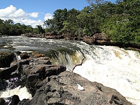
Uopianes and the Serra Pacaás Novos. It is fed by a region without major deforestation and silting of the river's margins. It has rapids, but always with a drop of less than 2 metres (6 ft 7 in). The most rugged stretch is between Redenção e Bom Destino. It is navigable, even in the middle section around Bom Destino, but only in the rainy season.
269:
The area has been used for rubber extraction for more than 100 years, but only 6.5% of the land has been altered by human occupation. The residents earn income from production of flour and other agricultural products. There are five communities in the reserve. There are two schools, although only one
248:
The Rio Cautário State
Extractive Reserve was created by state decree 7.028 of 8 August 1995 with an area of about 146,499 hectares (362,010 acres) to support conservation and sustainable use of natural resources by the extractive population. It was placed under the Instituto de Terras e Colonização
231:
The Cautário River is a meandering river with clear water. The depth does not exceed 2 to 3 metres (6 ft 7 in to 9 ft 10 in) in the dry season, and about 5 to 6 metres (16 to 20 ft) in the short season of high water. The river rises in the Uru-Eu-Wau-Wau
Indigenous Territory
244:
On 18 November 1991 a ban was placed on settlement, deforestation, professional fishing, logging, mining and other activities in the proposed 151,625 hectares (374,670 acres) Rio Cautário
Sustainable Extraction State Forest. This ban did not apply to the small farmers, rubber tappers and fishing
235:
During the wet season extensive areas of the forest are flooded. The climate is hot and humid, with temperatures of 24 to 26 °C (75 to 79 °F) throughout the year. Annual rainfall varies from 1,400 to 2,500 millimetres (55 to 98 in). Altitudes range from 100 to 250 metres (330 to
277:
and Rondônia. There is also a plan for community forest management created due to decline in demand for rubber. The plan is to extract wood from 500 hectares (1,200 acres) per year in a managed area of 15,000 hectares (37,000 acres) Two serious obstacles to managing the reserve are its
260:
they had seized a motorcycle, a tractor and six trucks loaded with 695 cubic metres (24,500 cu ft) of logs and 105 cubic metres (3,700 cu ft) of sawed timber, 930 wooden stakes and various camping and fishing items.
270:
was operating in 2011, and two health centres. The reserve is managed by the
Associação de Seringueiros do Vale do Guaporé (AGUAPÉ). Residents strongly support AGUAPÉ, one of the best organised of such associations in the state.
236:
820 ft). The reserve is covered by open submontane rainforest (63%), pioneer alluvial formations (15.5%), dense alluvial rainforest (8.6%) and savanna (6.5%). The forest is well-preserved near the waterways.
256:(ARPA). In January 2016 SEDAM announced findings of illegal activity in the previous quarter in nine units that benefited from ARPA in the state. In the Rio Cautário State Extractive Reserve and the
96:
547:
Comunidades de seringueiros das
Reservas Extrativistas do Rio Cautário, RO: Aspectos socioeconômicos, percepção ambiental e potenciais conflitos na interação com a fauna
510:
59:
528:
212:
607:
612:
602:
253:
274:
475:
199:(52.5%) in the state of Rondônia. It has an area of 146,400 hectares (362,000 acres). The reserve lies to the northwest of the
33:
204:
568:
545:
176:
139:
597:
257:
168:
43:
458:
374:
372:
273:
There is a usage plan and a development plan created through technical cooperation between the
216:
220:
200:
192:
223:
on the border with
Bolivia. In the southwest the reserve is bounded by the Guaporé River.
591:
208:
196:
83:
426:
564:
191:
The Rio Cautário State
Extractive Reserve is divided between the municipalities of
511:"Sedam divulga resultado de fiscalização de unidades de conservação de Rondônia"
180:
111:
98:
553:(Thesis) (in Portuguese), Juiz De Fora: Universidade Federal de Juiz de Fora
215:
to the north of its eastern part, separated from the federal reserve by the
219:. The Cautário River runs through the west part of the reserve to join the
494:
437:
435:
359:
357:
355:
353:
316:
314:
378:
305:
293:
66:
36:
VI (protected area with sustainable use of natural resources)
530:
Unidade de
Conservação: Reserva Extrativista do Rio Cautário
414:
157:
332:
427:
Sedam divulga resultado de fiscalização ... Rondoniagora
390:
278:inaccessibility and the illiteracy of the leaders.
153:
145:
135:
127:
90:
79:
21:
402:
533:(in Portuguese), MMA: Ministério do Meio Ambiente
441:
363:
344:
320:
499:(in Portuguese), ISA: Instituto Socioambiental
8:
252:As of 2016 the reserve was supported by the
211:on the border with Bolivia. It adjoins the
477:Decreto nº 14.497, de 21 de Agosto de 2009
173:Reserva Extrativista Estadual Rio Cautário
27:Reserva Extrativista Estadual Rio Cautário
18:
570:Decreto nº 7.028, de 08 de Agosto de 1995
286:
213:Rio Cautário Federal Extractive Reserve
16:Extractive reserve in Rondônia, Brazil
474:Ivo Narciso Cassol (21 August 2009),
254:Amazon Region Protected Areas Program
165:Rio Cautário State Extractive Reserve
22:Rio Cautário State Extractive Reserve
7:
275:United Nations Development Programme
379:RESEX Rio Cautário (Estadual) – ISA
306:RESEX Rio Cautário (Estadual) – ISA
294:RESEX Rio Cautário (Estadual) – ISA
14:
460:Full list: PAs supported by ARPA
415:Full list: PAs supported by ARPA
131:146,400 hectares (362,000 acres)
65:
58:
42:
517:(in Portuguese), 6 January 2016
144:
78:
333:Unidade de Conservação ... MMA
1:
613:1995 establishments in Brazil
603:Extractive reserves of Brazil
496:RESEX Rio Cautário (Estadual)
308:, Informações gerais (mapa).
608:Protected areas of Rondônia
245:people living in the area.
48:Falls on the Cautário River
629:
544:Verônica Belchior (2011),
391:Valdir Raupp De Matos 1995
258:Serra dos Reis State Park
53:
41:
31:
26:
205:São Francisco do Guaporé
403:Ivo Narciso Cassol 2009
442:Verônica Belchior 2011
364:Verônica Belchior 2011
345:Verônica Belchior 2011
321:Verônica Belchior 2011
172:
112:12.04839°S 64.291624°W
565:Valdir Raupp De Matos
381:, Historico Juridico.
296:, Informações gerais.
117:-12.04839; -64.291624
108: /
177:extractive reserve
140:Extractive reserve
567:(8 August 1995),
161:
160:
80:Nearest city
620:
598:IUCN Category VI
583:
582:
581:
575:
560:
559:
558:
552:
540:
539:
538:
524:
523:
522:
506:
505:
504:
490:
489:
488:
482:
470:
469:
468:
445:
439:
430:
424:
418:
412:
406:
400:
394:
388:
382:
376:
367:
361:
348:
342:
336:
330:
324:
318:
309:
303:
297:
291:
179:in the state of
123:
122:
120:
119:
118:
113:
109:
106:
105:
104:
101:
69:
68:
62:
46:
19:
628:
627:
623:
622:
621:
619:
618:
617:
588:
587:
586:
579:
577:
576:(in Portuguese)
573:
563:
556:
554:
550:
543:
536:
534:
527:
520:
518:
509:
502:
500:
493:
486:
484:
483:(in Portuguese)
480:
473:
466:
464:
457:
453:
448:
440:
433:
425:
421:
413:
409:
401:
397:
389:
385:
377:
370:
362:
351:
347:, pp. 7–8.
343:
339:
331:
327:
319:
312:
304:
300:
292:
288:
284:
267:
242:
229:
189:
116:
114:
110:
107:
102:
99:
97:
95:
94:
75:
74:
73:
72:
71:
70:
49:
37:
17:
12:
11:
5:
626:
624:
616:
615:
610:
605:
600:
590:
589:
585:
584:
561:
541:
525:
507:
491:
471:
454:
452:
449:
447:
446:
431:
419:
407:
395:
383:
368:
349:
337:
325:
310:
298:
285:
283:
280:
266:
263:
241:
238:
228:
225:
217:Cautário River
188:
185:
159:
158:
155:
151:
150:
147:
143:
142:
137:
133:
132:
129:
125:
124:
92:
88:
87:
81:
77:
76:
64:
63:
57:
56:
55:
54:
51:
50:
47:
39:
38:
32:
29:
28:
24:
23:
15:
13:
10:
9:
6:
4:
3:
2:
625:
614:
611:
609:
606:
604:
601:
599:
596:
595:
593:
572:
571:
566:
562:
549:
548:
542:
532:
531:
526:
516:
512:
508:
498:
497:
492:
479:
478:
472:
462:
461:
456:
455:
450:
443:
438:
436:
432:
428:
423:
420:
416:
411:
408:
404:
399:
396:
392:
387:
384:
380:
375:
373:
369:
365:
360:
358:
356:
354:
350:
346:
341:
338:
334:
329:
326:
322:
317:
315:
311:
307:
302:
299:
295:
290:
287:
281:
279:
276:
271:
264:
262:
259:
255:
250:
246:
239:
237:
233:
226:
224:
222:
221:Guaporé River
218:
214:
210:
209:Costa Marques
206:
203:highway from
202:
198:
197:Costa Marques
194:
193:Guajará-Mirim
186:
184:
182:
178:
174:
170:
166:
156:
154:Administrator
152:
149:8 August 1995
148:
141:
138:
134:
130:
126:
121:
93:
89:
85:
84:Costa Marques
82:
61:
52:
45:
40:
35:
34:IUCN category
30:
25:
20:
578:, retrieved
569:
555:, retrieved
546:
535:, retrieved
529:
519:, retrieved
515:Rondoniagora
514:
501:, retrieved
495:
485:, retrieved
476:
465:, retrieved
459:
444:, p. 9.
422:
410:
398:
386:
366:, p. 8.
340:
328:
323:, p. 7.
301:
289:
272:
268:
251:
247:
243:
234:
230:
195:(47.5%) and
190:
164:
162:
227:Environment
136:Designation
115: /
91:Coordinates
592:Categories
580:2016-09-15
557:2016-09-15
537:2016-09-15
521:2016-08-07
503:2016-09-15
487:2016-09-15
467:2016-08-07
183:, Brazil.
169:Portuguese
103:64°17′30″W
100:12°02′54″S
86:, Rondônia
187:Location
181:Rondônia
175:) is an
451:Sources
265:Economy
240:History
146:Created
463:, ARPA
201:BR-429
574:(PDF)
551:(PDF)
481:(PDF)
282:Notes
163:The
128:Area
207:to
594::
513:,
434:^
371:^
352:^
313:^
171::
429:.
417:.
405:.
393:.
335:.
167:(
Text is available under the Creative Commons Attribution-ShareAlike License. Additional terms may apply.