105:
136:
562:
546:
194:
1017:
78:
1088:
994:
899:
59:
1411:
143:
112:
770:
of the
Cagayan River and its tributaries have caused great loss of life and property and substantial losses to the local and national economies. The Philippine government has established several flood warning stations along the river. Experts are specifically monitoring the lower reaches from
755:
The average annual rainfall in 1,000 millimetres (39 in) in the northern part and 3,000 millimetres (120 in) in the southern mountains where the river's headwaters lie. Water from the mountains flow down very slowly because of surface retention over the extensive
930:
and regular severe storms, even traditional agricultural means are insufficient to feed families although they were bountiful in the past century, leading to the more aggressive use of destructive techniques. This has been part of a vicious cycle of
949:
are directly across the river from each other. A crossing by boat was the most convenient, but emergencies could be dangerous, such as having to fetch the doctor in
Gattaran during a storm at night. Now the best way is by vehicle over the
1453:
794:(Ulysses), the river reached its peak level and caused floods along its vicinity due to the rainfall accumulated from the typhoon. This flooding was one of the worst floods in the river's history. The
1298:
1446:
676:
and drains the eastern central portion of the
Cagayan River basin with an estimated yearly discharge of 9,455 million cubic meters. It flows westward and joins the Cagayan River at
545:
1439:
1329:
104:
135:
1306:
286:
1605:
856:
Due to the dwindling number of ludong caught yearly, local governments have imposed a ban on catching the fish and its fry, but the ban has failed.
1360:
1240:"Water Quality Management in the Context of Basin Management: Water Quality, River Basin Management and Governance Dynamics in the Philippines"
600:
at an elevation of approximately 1,524 metres (5,000 ft). The river flows north for some 505 kilometres (314 mi) to its mouth at the
569:
363:
612:. The river drops rapidly to 91 metres (299 ft) above sea level some 227 kilometres (141 mi) from the river mouth. Its principal
911:
The river drains a fertile valley that produces a variety of crops, including rice, corn, bananas, coconut, mangoes, citrus and tobacco.
1610:
1595:
1576:
1186:
972:
The provincial governments along the river have also developed tourism programs that offer activities on the river, particularly
850:. In late October until mid-November, the fish travel down the river to release their eggs at the river mouth near Aparri.
1615:
1600:
1024:
736:
The estimated annual discharge is 53,943 million cubic meters with a groundwater reserve of 47,895 million cubic meters.
514:
1177:
generally follows the course of the river from
Echague until the Magapit Suspension Bridge where it continues west.
687:
ranges flowing almost parallel to the Magat River. Marshes and swamps are found in some parts of its lower reaches.
966:
703:
699:
698:
origin, mostly limestone sands and clays, throughout the relatively flat
Cagayan Valley which is surrounded by the
684:
673:
1288:"Principal River Basins of the Philippines", Published by the National Water Resources Board, October 1976 (p. 12)
1020:
988:
962:
951:
932:
880:. These provinces have an approximate population of two million people, mostly farmers and indigenous tribesmen.
621:
442:
1330:"Residents near Ipo, Ambuklao, Binga, and Magat dams warned of flooding as reservoirs continue to release water"
1512:
1415:
35:
713:
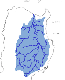
The river has a drainage area of about 27,300 square kilometres (10,500 sq mi). in the provinces of
1347:
Magat Dam in
Isabela province has also released water at 5,073 cms as seven gates have been opened 24 meters.
1209:
1551:
1174:
1095:
1091:
1061:
1001:
997:
821:
815:
813:
It supports the lives of numerous endemic and endangered species, like the Luzon bleeding-heart pigeon (
647:
494:
798:
also contributed to the floods along the river when its floodgates opened due to a potential overflow.
669:
Both Magat and Chico Rivers have extensive drainage areas which comprise about 1/3 of the whole basin.
1054:
1039:
791:
707:
593:
259:
629:
1113:
1099:
973:
938:
Families still go to the banks of the river and its tributaries to wash clothes or have picnics.
873:
835:
625:
526:
227:
68:
853:
In
February, ludong fry by the millions are again caught in fine nets as these travel upstream.
561:
1268:
1065:
915:
914:
Fish were a plentiful source of nutrition for centuries, but in recent decades issues such as
784:
730:
617:
470:
1431:
1159:
1152:
1127:
1120:
1106:
1050:
1043:
919:
726:
1365:
1334:
1072:
1032:
1028:
1005:
722:
718:
714:
677:
601:
349:
337:
174:
902:
An old drawn geographical description of
Cagayan River (Juan Luis de Acosta, Circa 1720)
77:
1556:
1545:
1530:
1392:
1145:
1138:
927:
923:
892:
847:
807:
776:
749:
651:
506:
502:
209:
82:
64:
1589:
1079:
1011:
884:
865:
655:
597:
518:
271:
232:
17:
1525:
1494:
744:
The
Cagayan River and its tributaries are subject to extensive flooding during the
637:
510:
465:
898:
1361:"Widespread flooding in Isabela, Cagayan feared as Magat Dam releases more water"
505:
covering 27,753 square kilometres (10,715 sq mi). It is located in the
1541:
1535:
1517:
1499:
1463:
1299:"Flood Forecasting and Warning System for River Basins; The Cagayan River Basin"
941:
Until recently, boatmen would provide ferry service. For example, the towns of
757:
663:
643:
633:
613:
498:
447:
332:
199:
120:
86:
1564:
1489:
1484:
1474:
1239:
1166:
772:
767:
695:
659:
589:
378:
365:
301:
288:
1422:
Philippine
Atmospheric, Geophysical and Astronomical Services Administration
1303:
Philippine Atmospheric, Geophysical and Astronomical Services Administration
1133:
Dalibubon Bridge (Santiago–San Agustin Road and Echague–Jones–Maddela Road,
795:
501:. It has a total length of approximately 505 kilometres (314 mi) and a
58:
1410:
650:
of 9,808 million cubic meters. It lies in the southwestern portion of the
946:
826:
691:
31:
764:
in the gently-sloping mountains and the meandering course of the river.
1134:
877:
869:
745:
609:
530:
522:
237:
222:
1426:
1479:
895:
lived in the upper reaches of the Cagayan River and its tributaries.
780:
605:
965:, and there are also several mining concessions in the mineral-rich
942:
761:
90:
1421:
1435:
958:
926:
have led to a great decline in the river's fish stocks. With
690:
Cagayan River and its tributaries have deposited sediments of
887:
derive their tribe's name from Cagayan River's ancient name,
662:
with Cagayan River about 55 kilometres (34 mi) from the
654:, stretching approximately 150 kilometres (93 mi) from
1398:. Berkeley and Los Angeles: University of California Press.
1049:
Cansan-Bagutari Overflow Bridge (Cabagan-Santo Tomas Road,
672:
The Ilagan River originates from the western slopes of the
806:
The Cagayan River passes through one of the few remaining
683:
The Siffu-Mallig system lies on the slope of the Central
1060:
Delfin Albano Bridge (Ilagan–Delfin Albano–Mallig Road,
1038:
Santa Maria Overflow Bridge (Cabagan–Santa Maria Road,
646:, is the largest tributary with an estimated annual
1071:Lullutan Bridge (Ilagan–Delfin Albano–Mallig Road,
456:
433:
425:
420:
412:
404:
394:
355:
343:
331:
317:
278:
265:
255:
246:
215:
205:
187:
182:
162:
45:
1391:
1328:San Juan, Alexandria Dennise (November 13, 2020).
1249:. Department of Environment and Natural Resources
1165:Abbag Bridge (Cordon–Diffun–Maddela–Aurora Road,
969:near the headwaters of the two tributary rivers.
961:in two of the river's tributaries, the Magat and
493:, is the longest river and the largest river by
680:, 200 kilometres (120 mi) from the mouth.
1447:
8:
1238:Vicente B. Tuddao Jr. (September 21, 2011).
1203:
1201:
1144:Jones II Bridge (Santiago–San Agustin Road,
166:
1359:De Vera-Ruiz, Ellalyn (November 12, 2020).
846:spawns in Cagayan River's upper reaches in
1454:
1440:
1432:
1112:New Pigalo Bridge (Angadanan–Alicia Road,
560:
76:
790:In November 2020, after the onslaught of
1390:Wernstedt, F. L.; J. E. Spencer (1967).
1269:"Taming the Cagayan River, Inquirer.net"
897:
1197:
416:27,753 km (10,715 sq mi)
1233:
1231:
42:
1208:Kenneth Kimutai too (July 24, 2018).
142:
111:
7:
864:The river traverses four provinces:
1210:"Longest Rivers In The Philippines"
25:
1577:List of rivers of the Philippines
1187:List of rivers of the Philippines
1409:
1086:
1015:
992:
544:
192:
141:
134:
110:
103:
57:
27:Longest river in the Philippines
1606:Landforms of Isabela (province)
1462:Principal River Systems of the
509:region in northeastern part of
63:The river as it passes through
1078:Gamu Bridge (Gamu–Roxas Road,
733:, Nueva Vizcaya, and Quirino.
357: • coordinates
280: • coordinates
1:
247:Physical characteristics
396: • elevation
323:1,524 m (5,000 ft)
319: • elevation
1394:The Philippine Island World
1105:Alicaocao Overflow Bridge (
924:burgeoning human population
920:destructive fishing methods
345: • location
267: • location
150:Cagayan River (Philippines)
1632:
1611:Landforms of Nueva Vizcaya
1119:Anafunan Overflow Bridge (
928:worsening weather patterns
29:
1596:Rivers of the Philippines
1573:
1470:
989:Magapit Suspension Bridge
933:environmental degradation
479:
408:505 km (314 mi)
327:
251:
97:
75:
56:
30:For the Cagayan River in
1025:Santiago–Tuguegarao Road
458: • right
36:Cagayan River (Mindanao)
1126:Gucab Overflow Bridge (
497:volume of water in the
435: • left
167:
153:Show map of Philippines
1552:Rio Grande de Mindanao
1540:Pasig/Marikina basin (
1175:Pan-Philippine Highway
1096:Pan-Philippine Highway
1002:Pan-Philippine Highway
984:From mouth to source:
903:
583:in northeastern Luzon.
302:16.18556°N 121.14417°E
1561:Tagum-Libuganon River
1522:Ilog-Hilabangan River
1504:Buayan-Malungun River
901:
829:fish, locally called
822:Pithecophaga jefferyi
819:), Philippine eagle (
816:Gallicolumba luzonica
752:from May to October.
491:Río Grande de Cagayán
85:of the river and its
50:Río Grande de Cagayán
18:Rio Grande de Cagayan
1616:Landforms of Quirino
1601:Landforms of Cagayan
1513:Cagayan de Oro River
1427:International Rivers
1418:at Wikimedia Commons
1055:Santo Tomas, Isabela
967:Cordillera Mountains
836:Cestreaus plicatilis
810:in the Philippines.
706:in the east and the
700:Cordillera Mountains
489:, also known as the
400:0 m (0 ft)
1167:Nagtipunan, Quirino
907:Economic importance
708:Caraballo Mountains
594:Caraballo Mountains
421:Basin features
375: /
307:16.18556; 121.14417
298: /
260:Caraballo Mountains
1151:San Pedro Bridge (
1114:Angadanan, Isabela
1100:Naguilian, Isabela
1085:Naguilian Bridge (
974:whitewater rafting
904:
775:to Aparri and the
572:Topography of the
513:and traverses the
379:18.367°N 121.617°E
1583:
1582:
1414:Media related to
1309:on March 12, 2016
1158:Dumabato Bridge (
1066:Tumauini, Isabela
916:fertilizer runoff
785:Tumauini, Isabela
731:Mountain Province
604:near the town of
483:
482:
471:Pinacanauan River
125:Show map of Luzon
16:(Redirected from
1623:
1456:
1449:
1442:
1433:
1413:
1399:
1397:
1378:
1377:
1375:
1373:
1356:
1350:
1349:
1344:
1342:
1325:
1319:
1318:
1316:
1314:
1305:. Archived from
1295:
1289:
1286:
1280:
1279:
1277:
1275:
1265:
1259:
1258:
1256:
1254:
1244:
1235:
1226:
1225:
1223:
1221:
1205:
1160:Maddela, Quirino
1153:Maddela, Quirino
1128:Echague, Isabela
1121:Echague, Isabela
1107:Cauayan, Isabela
1090:
1089:
1044:Cabagan, Isabela
1019:
1018:
996:
995:
564:
556:
548:
459:
436:
390:
389:
387:
386:
385:
380:
376:
373:
372:
371:
368:
320:
313:
312:
310:
309:
308:
303:
299:
296:
295:
294:
291:
281:
268:
198:
196:
195:
178:
170:
154:
145:
144:
138:
126:
114:
113:
107:
89:in northeastern
80:
61:
43:
21:
1631:
1630:
1626:
1625:
1624:
1622:
1621:
1620:
1586:
1585:
1584:
1579:
1569:
1466:
1460:
1406:
1389:
1386:
1384:Further reading
1381:
1371:
1369:
1366:Manila Bulletin
1358:
1357:
1353:
1340:
1338:
1335:Manila Bulletin
1327:
1326:
1322:
1312:
1310:
1297:
1296:
1292:
1287:
1283:
1273:
1271:
1267:
1266:
1262:
1252:
1250:
1247:www.wepa-db.net
1242:
1237:
1236:
1229:
1219:
1217:
1207:
1206:
1199:
1195:
1183:
1087:
1073:Ilagan, Isabela
1033:Solana, Cagayan
1029:Tuguegarao City
1016:
1006:Lal-lo, Cagayan
993:
982:
909:
862:
808:primary forests
804:
802:Flora and fauna
742:
678:Ilagan, Isabela
602:Babuyan Channel
586:
585:
584:
582:
571:
566:
565:
558:
557:
552:
549:
539:
475:
457:
452:
434:
397:
384:18.367; 121.617
383:
381:
377:
374:
369:
366:
364:
362:
361:
358:
350:Aparri, Cagayan
346:
338:Babuyan Channel
318:
306:
304:
300:
297:
292:
289:
287:
285:
284:
279:
274:, Nueva Vizcaya
266:
242:
193:
191:
172:
158:
157:
156:
155:
152:
151:
148:
147:
146:
129:
128:
127:
124:
123:
117:
116:
115:
93:
71:
52:
47:
39:
28:
23:
22:
15:
12:
11:
5:
1629:
1627:
1619:
1618:
1613:
1608:
1603:
1598:
1588:
1587:
1581:
1580:
1574:
1571:
1570:
1568:
1567:
1562:
1559:
1557:Tagoloan River
1554:
1549:
1546:Marikina River
1538:
1533:
1531:Pampanga River
1528:
1523:
1520:
1515:
1510:
1505:
1502:
1497:
1492:
1487:
1482:
1477:
1471:
1468:
1467:
1461:
1459:
1458:
1451:
1444:
1436:
1430:
1429:
1424:
1419:
1405:
1404:External links
1402:
1401:
1400:
1385:
1382:
1380:
1379:
1351:
1320:
1290:
1281:
1260:
1227:
1214:worldatlas.com
1196:
1194:
1191:
1190:
1189:
1182:
1179:
1171:
1170:
1163:
1156:
1149:
1146:Jones, Isabela
1142:
1139:Jones, Isabela
1131:
1124:
1117:
1110:
1103:
1083:
1076:
1069:
1058:
1047:
1036:
1009:
981:
978:
952:Magapit bridge
908:
905:
861:
858:
848:Jones, Isabela
803:
800:
777:alluvial plain
750:Southeast Asia
741:
738:
710:in the south.
577:(marked by an
576:
574:Cagayan Valley
568:
567:
559:
551:
550:
543:
542:
541:
540:
538:
535:
507:Cagayan Valley
503:drainage basin
481:
480:
477:
476:
474:
473:
468:
462:
460:
454:
453:
451:
450:
445:
439:
437:
431:
430:
427:
423:
422:
418:
417:
414:
410:
409:
406:
402:
401:
398:
395:
392:
391:
359:
356:
353:
352:
347:
344:
341:
340:
335:
329:
328:
325:
324:
321:
315:
314:
282:
276:
275:
269:
263:
262:
257:
253:
252:
249:
248:
244:
243:
241:
240:
235:
230:
225:
219:
217:
213:
212:
210:Cagayan Valley
207:
203:
202:
189:
185:
184:
180:
179:
164:
160:
159:
149:
140:
139:
133:
132:
131:
130:
119:Cagayan River
118:
109:
108:
102:
101:
100:
99:
98:
95:
94:
81:
73:
72:
62:
54:
53:
48:
26:
24:
14:
13:
10:
9:
6:
4:
3:
2:
1628:
1617:
1614:
1612:
1609:
1607:
1604:
1602:
1599:
1597:
1594:
1593:
1591:
1578:
1572:
1566:
1563:
1560:
1558:
1555:
1553:
1550:
1547:
1543:
1539:
1537:
1534:
1532:
1529:
1527:
1524:
1521:
1519:
1516:
1514:
1511:
1509:
1508:Cagayan River
1506:
1503:
1501:
1498:
1496:
1493:
1491:
1488:
1486:
1483:
1481:
1478:
1476:
1473:
1472:
1469:
1465:
1457:
1452:
1450:
1445:
1443:
1438:
1437:
1434:
1428:
1425:
1423:
1420:
1417:
1416:Cagayan River
1412:
1408:
1407:
1403:
1396:
1395:
1388:
1387:
1383:
1368:
1367:
1362:
1355:
1352:
1348:
1337:
1336:
1331:
1324:
1321:
1308:
1304:
1300:
1294:
1291:
1285:
1282:
1270:
1264:
1261:
1248:
1241:
1234:
1232:
1228:
1215:
1211:
1204:
1202:
1198:
1192:
1188:
1185:
1184:
1180:
1178:
1176:
1168:
1164:
1161:
1157:
1154:
1150:
1147:
1143:
1140:
1136:
1132:
1129:
1125:
1122:
1118:
1115:
1111:
1108:
1104:
1101:
1097:
1093:
1084:
1081:
1080:Gamu, Isabela
1077:
1074:
1070:
1067:
1063:
1062:Delfin Albano
1059:
1056:
1052:
1048:
1045:
1041:
1037:
1034:
1030:
1026:
1022:
1013:
1012:Buntun Bridge
1010:
1007:
1003:
999:
990:
987:
986:
985:
979:
977:
975:
970:
968:
964:
960:
955:
953:
948:
944:
939:
936:
934:
929:
925:
921:
917:
912:
906:
900:
896:
894:
893:Gaddang tribe
890:
886:
885:Ibanag people
881:
879:
875:
871:
867:
866:Nueva Vizcaya
859:
857:
854:
851:
849:
845:
840:
838:
837:
832:
828:
825:) and a rare
824:
823:
818:
817:
811:
809:
801:
799:
797:
793:
792:Typhoon Vamco
788:
786:
782:
778:
774:
769:
765:
763:
759:
753:
751:
747:
739:
737:
734:
732:
728:
724:
720:
716:
711:
709:
705:
702:in the west,
701:
697:
693:
688:
686:
681:
679:
675:
670:
667:
665:
661:
657:
656:Nueva Vizcaya
653:
649:
645:
641:
639:
638:Ilagan Rivers
635:
631:
627:
623:
619:
615:
611:
607:
603:
599:
598:Central Luzon
595:
591:
580:
575:
570:
563:
555:
547:
536:
534:
532:
528:
524:
520:
519:Nueva Vizcaya
516:
512:
508:
504:
500:
496:
492:
488:
487:Cagayan River
478:
472:
469:
467:
464:
463:
461:
455:
449:
446:
444:
441:
440:
438:
432:
428:
424:
419:
415:
411:
407:
403:
399:
393:
388:
360:
354:
351:
348:
342:
339:
336:
334:
330:
326:
322:
316:
311:
283:
277:
273:
272:Dupax del Sur
270:
264:
261:
258:
254:
250:
245:
239:
236:
234:
233:Nueva Vizcaya
231:
229:
226:
224:
221:
220:
218:
214:
211:
208:
204:
201:
190:
186:
181:
176:
169:
165:
161:
137:
122:
106:
96:
92:
88:
84:
83:Drainage area
79:
74:
70:
66:
60:
55:
51:
46:Cagayan River
44:
41:
37:
33:
19:
1526:Jalaur River
1507:
1495:Agusan River
1480:Abulog River
1393:
1372:December 22,
1370:. Retrieved
1364:
1354:
1346:
1341:December 22,
1339:. Retrieved
1333:
1323:
1311:. Retrieved
1307:the original
1302:
1293:
1284:
1272:. Retrieved
1263:
1251:. Retrieved
1246:
1220:September 9,
1218:. Retrieved
1216:. WorldAtlas
1213:
1172:
983:
971:
963:Chico Rivers
956:
940:
937:
913:
910:
888:
882:
863:
855:
852:
843:
841:
834:
830:
820:
814:
812:
805:
789:
766:
754:
743:
735:
712:
704:Sierra Madre
689:
682:
674:Sierra Madre
671:
668:
658:down to its
642:
588:The river's
587:
578:
573:
553:
511:Luzon Island
490:
486:
484:
466:Ilagan River
49:
40:
1542:Pasig River
1536:Panay River
1518:Davao River
1500:Bicol River
1464:Philippines
1040:Santa Maria
768:Inundations
758:flood plain
725:, Isabela,
721:, Cagayan,
664:river mouth
644:Magat River
618:Pinacanauan
614:tributaries
592:are at the
499:Philippines
448:Magat River
443:Chico River
426:Tributaries
382: /
305: /
293:121°08′39″E
200:Philippines
163:Native name
87:tributaries
1590:Categories
1575:See also:
1565:Ulot River
1490:Agus River
1485:Agno River
1475:Abra River
1193:References
1092:AH 26 (N1)
998:AH 26 (N1)
957:There are
773:Tuguegarao
748:season in
696:Quaternary
685:Cordillera
660:confluence
590:headwaters
537:Topography
413:Basin size
290:16°11′08″N
1313:March 12,
980:Crossings
796:Magat Dam
648:discharge
515:provinces
495:discharge
1253:April 5,
1181:See also
947:Gattaran
827:riverine
740:Flooding
692:Tertiary
616:are the
370:121°37′E
216:Province
183:Location
32:Mindanao
1274:May 20,
1135:Echague
1051:Cabagan
878:Cagayan
874:Isabela
870:Quirino
746:monsoon
727:Kalinga
610:Cagayan
596:of the
531:Cagayan
527:Isabela
523:Quirino
367:18°22′N
238:Quirino
228:Isabela
223:Cagayan
188:Country
69:Isabela
922:and a
891:. The
889:Bannag
860:People
844:ludong
831:ludong
781:Ilagan
762:gorges
760:, the
723:Ifugao
719:Aurora
715:Apayao
630:Mallig
606:Aparri
429:
405:Length
256:Source
206:Region
197:
175:Ibanag
171:
168:Bannag
34:, see
1243:(PDF)
943:Lasam
779:from
652:basin
634:Magat
626:Siffu
622:Chico
333:Mouth
121:mouth
91:Luzon
65:Jones
1544:and
1374:2020
1343:2020
1315:2016
1276:2017
1255:2017
1222:2019
1173:The
1137:and
1064:and
1053:and
1042:and
1031:and
959:dams
945:and
883:The
876:and
842:The
694:and
636:and
529:and
485:The
1098:),
1027:),
1021:N51
1004:),
839:).
783:to
517:of
67:in
1592::
1363:.
1345:.
1332:.
1301:.
1245:.
1230:^
1212:.
1200:^
976:.
954:.
935:.
918:,
872:,
868:,
787:.
729:,
717:,
666:.
640:.
632:,
628:,
624:,
620:,
608:,
533:.
525:,
521:,
1548:)
1455:e
1448:t
1441:v
1376:.
1317:.
1278:.
1257:.
1224:.
1169:)
1162:)
1155:)
1148:)
1141:)
1130:)
1123:)
1116:)
1109:)
1102:)
1094:(
1082:)
1075:)
1068:)
1057:)
1046:)
1035:)
1023:(
1014:(
1008:)
1000:(
991:(
833:(
581:)
579:X
554:X
177:)
173:(
38:.
20:)
Text is available under the Creative Commons Attribution-ShareAlike License. Additional terms may apply.