44:
61:
94:
509:
101:
68:
376:
is another name for the village which is most often used when one wants to avoid ambiguity between the village of
Ringebu and the municipality of Ringebu. The name Vålebru comes from the local river Våla, which flows through the village, and the bridge that was laid over the river here.
579:
550:
60:
43:
129:
584:
543:
207:
349:
railway line both pass through the village. The 1.85-square-kilometre (460-acre) village has a population (2021) of 1353 and a
417:
574:
291:
93:
536:
171:
448:
318:
270:
338:
357:
322:
280:
212:
195:
350:
183:
453:
399:
342:
520:
569:
403:
200:
176:
563:
508:
372:
which is the same as the name of the municipality in which it is located. The name
334:
346:
287:
266:
474:
360:
is located about 3 kilometres (1.9 mi) to the southeast of the village.
144:
131:
516:
326:
261:
188:
330:
164:
443:
421:
353:
of 733 inhabitants per square kilometre (1,900/sq mi).
404:"Urban settlements. Population and area, by municipality"
524:
298:
277:
260:
252:
244:
239:
231:
223:
218:
206:
194:
182:
170:
160:
24:
544:
8:
580:Populated places on the Gudbrandsdalslågen
551:
537:
21:
386:
297:
259:
238:
230:
217:
159:
124:
52:
40:
394:
392:
390:
276:
251:
243:
222:
205:
193:
181:
169:
7:
505:
503:
442:Mæhlum, Lars, ed. (29 March 2022).
227:1.85 km (0.71 sq mi)
523:. You can help Knowledge (XXG) by
14:
19:Village in Eastern Norway, Norway
507:
333:. The village is located in the
99:
92:
66:
59:
42:
100:
67:
1:
601:
502:
475:"Vet du dette om Ringebu?"
16:Village in Ringebu, Norway
585:Innlandet geography stubs
256:733/km (1,900/sq mi)
125:
53:
41:
34:
235:199 m (653 ft)
80:Location of the village
519:location article is a
400:Statistisk sentralbyrå
575:Villages in Innlandet
449:Store norske leksikon
368:The village is named
319:administrative centre
279: • Summer (
145:61.52965°N 10.13889°E
83:Show map of Innlandet
444:"Ringebu (tettsted)"
358:Ringebu Stave Church
323:Ringebu Municipality
253: • Density
213:Ringebu Municipality
141: /
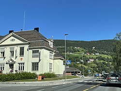
48:View of the village
479:Gudbrandsdalsvegen
418:"Ringebu, Ringebu"
402:(1 January 2021).
351:population density
339:Gudbrandsdalslågen
337:valley, along the
245: • Total
224: • Total
150:61.52965; 10.13889
116:Show map of Norway
29:Vålebru / Vålebrua
532:
531:
454:Kunnskapsforlaget
343:European route E6
308:
307:
592:
553:
546:
539:
511:
504:
491:
490:
488:
486:
471:
465:
464:
462:
460:
452:(in Norwegian).
439:
433:
432:
430:
428:
414:
408:
407:
396:
345:highway and the
284:
156:
155:
153:
152:
151:
146:
142:
139:
138:
137:
134:
117:
113:Ringebu (Norway)
103:
102:
96:
84:
70:
69:
63:
46:
22:
600:
599:
595:
594:
593:
591:
590:
589:
560:
559:
558:
557:
500:
497:
495:
494:
484:
482:
473:
472:
468:
458:
456:
441:
440:
436:
426:
424:
416:
415:
411:
398:
397:
388:
383:
366:
304:
278:
149:
147:
143:
140:
135:
132:
130:
128:
127:
121:
120:
119:
118:
115:
114:
111:
110:
109:
108:
104:
87:
86:
85:
82:
81:
78:
77:
76:
75:
71:
49:
37:
30:
27:
20:
17:
12:
11:
5:
598:
596:
588:
587:
582:
577:
572:
562:
561:
556:
555:
548:
541:
533:
530:
529:
512:
493:
492:
481:(in Norwegian)
466:
434:
409:
385:
384:
382:
379:
365:
362:
306:
305:
302:
300:
296:
295:
285:
275:
274:
264:
258:
257:
254:
250:
249:
246:
242:
241:
237:
236:
233:
229:
228:
225:
221:
220:
216:
215:
210:
204:
203:
201:Gudbrandsdalen
198:
192:
191:
186:
180:
179:
177:Eastern Norway
174:
168:
167:
162:
158:
157:
123:
122:
112:
106:
105:
98:
97:
91:
90:
89:
88:
79:
73:
72:
65:
64:
58:
57:
56:
55:
54:
51:
50:
47:
39:
38:
35:
32:
31:
28:
25:
18:
15:
13:
10:
9:
6:
4:
3:
2:
597:
586:
583:
581:
578:
576:
573:
571:
568:
567:
565:
554:
549:
547:
542:
540:
535:
534:
528:
526:
522:
518:
513:
510:
506:
501:
498:
480:
476:
470:
467:
455:
451:
450:
445:
438:
435:
423:
419:
413:
410:
405:
401:
395:
393:
391:
387:
380:
378:
375:
371:
363:
361:
359:
354:
352:
348:
344:
340:
336:
332:
328:
324:
320:
316:
312:
301:
293:
289:
286:
282:
272:
268:
265:
263:
255:
247:
234:
226:
214:
211:
209:
202:
199:
197:
190:
187:
185:
178:
175:
173:
166:
163:
154:
126:Coordinates:
95:
62:
45:
33:
23:
525:expanding it
514:
499:
496:
483:. Retrieved
478:
469:
457:. Retrieved
447:
437:
425:. Retrieved
412:
373:
369:
367:
355:
335:Gudbrandsdal
314:
310:
309:
303:2630 Ringebu
208:Municipality
341:river. The
148: /
564:Categories
381:References
347:Dovrebanen
240:Population
136:10°08′20″E
133:61°31′47″N
517:Innlandet
327:Innlandet
299:Post Code
288:UTC+02:00
267:UTC+01:00
262:Time zone
232:Elevation
189:Innlandet
329:county,
196:District
570:Ringebu
485:14 June
459:14 June
427:14 June
374:Vålebru
370:Ringebu
317:is the
315:Vålebru
311:Ringebu
161:Country
107:Ringebu
74:Ringebu
36:Village
26:Ringebu
331:Norway
184:County
172:Region
165:Norway
515:This
422:yr.no
248:1,353
521:stub
487:2022
461:2022
429:2022
364:Name
356:The
292:CEST
219:Area
325:in
321:of
313:or
281:DST
271:CET
566::
477:.
446:.
420:.
389:^
552:e
545:t
538:v
527:.
489:.
463:.
431:.
406:.
294:)
290:(
283:)
273:)
269:(
Text is available under the Creative Commons Attribution-ShareAlike License. Additional terms may apply.