45:
29:
52:
362:
Further upstream along Gage Road and Ritner Creek is Ritner Creek Park, another county recreation site. Amenities include fire pits, picnic tables, walking trails, and a restroom. This park is also open all year between sunrise and a half-hour after sunset.
358:
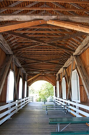
The covered bridge was saved and moved to an adjacent site that doubles as a small county park, the Minnie Ritner Ruiter
Wayside. The park, open all year during daylight hours, has picnic tables and a portable restroom.
579:
44:
330:, carried the highway over the creek until 1976. Replaced by a concrete span, it was the last covered bridge on an Oregon state highway.
469:
435:
233:
155:
347:
296:
131:
584:
372:
395:
492:
426:
339:
76:
315:. Named tributaries of Ritner Creek from source to mouth are Sheythe, Love, Clayton, and Kinsey creeks.
304:
323:
284:
112:
28:
431:
319:
312:
280:
206:
327:
573:
300:
219:
92:
451:
517:
539:
430:(7th ed.). Portland, Oregon: Oregon Historical Society Press. p. 813.
308:
201:
338:
The creek was named for
Sebastian Ritner, who emigrated to Oregon in 1845. His
288:
248:
235:
170:
157:
350:. It was along the line about 2 miles (3 km) north of Kings Valley.
307:. The confluence is 31 miles (50 km) upstream of the Luckiamute's
72:
292:
102:
299:
and flows generally southeast to meet the
Luckiamute southwest of
564:
482:. The map includes mile markers along the Luckiamute River.
342:
included part of the creek. A railroad station named
402:. United States Geological Survey. November 28, 1980
264:
225:
212:
200:
186:
147:
137:
127:
118:
108:
98:
88:
83:
67:
21:
424:McArthur, Lewis A.; McArthur, Lewis L. (2003) .
59:Location of the mouth of Ritner Creek in Oregon
295:. The creek begins near Bald Mountain in the
8:
464:
462:
460:
384:
390:
388:
18:
498:. Oregon Department of Transportation
454:search using GNIS source coordinates.
419:
417:
7:
322:just before entering the river. The
51:
33:Ritner Creek Bridge interior in 2011
400:Geographic Names Information System
14:
472:. United States Geological Survey
50:
43:
27:
470:"United States Topographic Map"
450:Source elevation derived from
227: • coordinates
149: • coordinates
16:River in Oregon, United States
1:
580:Rivers of Polk County, Oregon
493:"Ritner Creek Covered Bridge"
119:Physical characteristics
565:Luckiamute Watershed Council
266: • elevation
188: • elevation
214: • location
139: • location
601:
348:Valley and Siletz Railroad
318:Ritner Creek passes under
297:Central Oregon Coast Range
192:1,292 ft (394 m)
132:Central Oregon Coast Range
196:
123:
38:
26:
480:– via Acme Mapper.
373:List of rivers of Oregon
326:, a 75-foot (23 m)
71:For Sebastian Ritner, a
427:Oregon Geographic Names
270:279 ft (85 m)
279:is a tributary of the
249:44.72861°N 123.44333°W
171:44.77417°N 123.54139°W
542:. Polk County, Oregon
520:. Polk County, Oregon
518:"Ritner Creek Bridge"
254:44.72861; -123.44333
176:44.77417; -123.54139
540:"Ritner Creek Park"
340:donation land claim
324:Ritner Creek Bridge
245: /
167: /
79:was along the creek
77:donation land claim
143:near Bald Mountain
274:
273:
592:
585:Rivers of Oregon
552:
551:
549:
547:
536:
530:
529:
527:
525:
514:
508:
507:
505:
503:
497:
489:
483:
481:
479:
477:
466:
455:
448:
442:
441:
421:
412:
411:
409:
407:
392:
346:was part of the
320:Oregon Route 223
313:Willamette River
281:Luckiamute River
260:
259:
257:
256:
255:
250:
246:
243:
242:
241:
238:
207:Luckiamute River
189:
182:
181:
179:
178:
177:
172:
168:
165:
164:
163:
160:
150:
140:
54:
53:
47:
31:
19:
600:
599:
595:
594:
593:
591:
590:
589:
570:
569:
561:
556:
555:
545:
543:
538:
537:
533:
523:
521:
516:
515:
511:
501:
499:
495:
491:
490:
486:
475:
473:
468:
467:
458:
449:
445:
438:
423:
422:
415:
405:
403:
394:
393:
386:
381:
369:
356:
336:
267:
253:
251:
247:
244:
239:
236:
234:
232:
231:
228:
215:
187:
175:
173:
169:
166:
161:
158:
156:
154:
153:
148:
138:
63:
62:
61:
60:
57:
56:
55:
34:
17:
12:
11:
5:
598:
596:
588:
587:
582:
572:
571:
568:
567:
560:
559:External links
557:
554:
553:
531:
509:
484:
456:
443:
436:
413:
396:"Ritner Creek"
383:
382:
380:
377:
376:
375:
368:
365:
355:
352:
335:
332:
328:covered bridge
272:
271:
268:
265:
262:
261:
229:
226:
223:
222:
216:
213:
210:
209:
204:
198:
197:
194:
193:
190:
184:
183:
151:
145:
144:
141:
135:
134:
129:
125:
124:
121:
120:
116:
115:
110:
106:
105:
100:
96:
95:
90:
86:
85:
81:
80:
69:
65:
64:
58:
49:
48:
42:
41:
40:
39:
36:
35:
32:
24:
23:
15:
13:
10:
9:
6:
4:
3:
2:
597:
586:
583:
581:
578:
577:
575:
566:
563:
562:
558:
541:
535:
532:
519:
513:
510:
494:
488:
485:
471:
465:
463:
461:
457:
453:
447:
444:
439:
437:0-87595-277-1
433:
429:
428:
420:
418:
414:
401:
397:
391:
389:
385:
378:
374:
371:
370:
366:
364:
360:
353:
351:
349:
345:
341:
333:
331:
329:
325:
321:
316:
314:
310:
306:
303:and north of
302:
298:
294:
290:
286:
282:
278:
269:
263:
258:
230:
224:
221:
217:
211:
208:
205:
203:
199:
195:
191:
185:
180:
152:
146:
142:
136:
133:
130:
126:
122:
117:
114:
111:
107:
104:
101:
97:
94:
93:United States
91:
87:
82:
78:
74:
70:
66:
46:
37:
30:
25:
20:
546:February 29,
544:. Retrieved
534:
524:February 29,
522:. Retrieved
512:
502:February 29,
500:. Retrieved
487:
476:February 29,
474:. Retrieved
452:Google Earth
446:
425:
406:February 29,
404:. Retrieved
399:
361:
357:
343:
337:
317:
305:Kings Valley
277:Ritner Creek
276:
275:
22:Ritner Creek
285:Polk County
252: /
240:123°26′36″W
174: /
162:123°32′29″W
574:Categories
379:References
289:U.S. state
237:44°43′43″N
159:44°46′27″N
218:south of
68:Etymology
367:See also
84:Location
311:on the
287:in the
89:Country
73:settler
434:
344:Ritner
293:Oregon
128:Source
109:County
103:Oregon
75:whose
496:(PDF)
354:Parks
309:mouth
301:Pedee
220:Pedee
202:Mouth
99:State
548:2016
526:2016
504:2016
478:2016
432:ISBN
408:2016
334:Name
113:Polk
291:of
283:in
576::
459:^
416:^
398:.
387:^
550:.
528:.
506:.
440:.
410:.
Text is available under the Creative Commons Attribution-ShareAlike License. Additional terms may apply.