2670:, obtained an Act of Parliament to authorise construction of the mill on the foreshore of land that he owned at Bishopstone. The first mill was completed in 1788, by which time Pelham had died. It was sold in 1791 to Thomas Barton, and the sale documents listed five pairs of stones, capable of producing 130 quarters of week each week. The new owner built a large mill with three storeys, capable of producing 1,500 sacks of flour each week, using 16 pairs of stones. The site was regularly affected by storms, with wheat and flour destroyed in 1792, while in 1820, the building was damaged and part of the dam was washed away. After 1853, the volume of flour produced gradually declined, often as a result of weather conditions, but it continued in operation until March 1883, when there was another violent storm and the new harbour at Newhaven required more water. The site which was known as
2612:
A forge was operational at the site in 1574, but was replaced by a corn mill when the iron industry declined. This was replaced by a three-storey brick and timber building at some point, which was later supplemented by a four-storey square extension with a flat roof, from which the owners, the Maryon-Wilson family, could watch cricket matches at
Sheffield Park. While the navigation was in use, there was a wharf just to the north of the mill, where barges moored to deliver grain or collect produce. The mill ceased to use water power in the 1920s, when Tidy & Sons owned it, but was in use until 1940, when the War Office requisitioned it to billet soldiers in it. Much of the fabric of the building was damaged during this period, and it was only used irregularly after the war, until it was demolished in 1950, as was the hump-back bridge at the front of the building.
2144:
prevented it from draining from the levels. He also commented on the great shingle bar crossing the mouth of the river at
Newhaven, which if removed would allow the water levels to be around 6.5 feet (2.0 m) lower at low tide. The brooks above Lewes Bridge became gradually drier as he progressed towards Barcombe Mill, but with almost no fall on the river, its winding course and numerous shoals hampered the drainage of the meadows. The brooks bordering the Glynde, to the east of Ranscombe, were generally at a higher level, but were affected by stagnant water lying on the surface. There was again no gradient on that river, which followed a winding course, but he was confident that if the drainage of Ranscombe could be solved, the drainage of the Laughton Levels would also be.
2119:
for navigation. At some time between 1676 and the publication of an
Admiralty chart in 1698, the river flowed along the back of the shingle bar and broke through into the sea about 0.5 miles (0.8 km) further to the east, at the site of a tide mill. The outlet at Newhaven had been reinstated by 1731, when the Newhaven Harbour Commissioners were established by act of Parliament. The engineer John Reynolds carried out some work for them on the piers at the entrance to the river, and constructed a sluice across it at Piddinghoe between 1731 and 1733, working for the Drainage Commissioners, but that was short lived, as it was damaged in 1736 and taken down rather than repaired. By the 18th century the valley was regularly inundated in winter and often flooded in summer.
2148:
allow water to drain away when required. A second option involved raising the banks on all of the meadows, and constructing a separate sewer to carry surplus water from them to the sea, leaving the main river largely unaltered. The outfall sluice would have been located at
Tarring Tenantry near Piddinghoe, and would contain three openings, two of 13 feet (4.0 m), each with a set of pointed doors facing in opposite directions, to prevent the sea entering the river, and to retain water in the river during dry periods. The third opening would be 14 feet (4.3 m) wide, with double pointed doors facing in both directions, so that it could additionally be used as a navigation lock at all states of the tide and river.
1950:, where the channel has been considerably modified over time, and is crossed by three bridges. Willey's Bridge is a small footbridge opened in 1965, to provide public access to South Malling church and to enable residents in housing estates built at Malling to get to Lewes. Previously, access to the church had only been available on Sundays, when owners of Malling Deanery allowed people to use their private suspension bridge, constructed in 1934, and located a little further upstream. This had in turn replaced a wooden bridge erected in 1868. The Phoenix Causeway is a larger road bridge named after the former Phoenix Ironworks, which was constructed in 1979 to provide a bypass for Cliffe High Street, and the
2594:
primarily protects agricultural land, it also offers some protection to around 2,000 properties. Following the floods of 1960, a further round of widening the channel and raising the banks below Lewes occurred, and where gravity drainage of the levels has proved ineffective, water is pumped into the river from land drainage ditches. Tidal water has been unable to enter the
Laughton Level since 1973, when a dam and pumping station was constructed across the Glynde Reach at Beddingham. There are land drainage pumping stations at Stoneham, Offham, Rodmell, ET Wadham, Ranscombe, Denton and Beddingham, with an eighth station at Lewes which pumps water into the Malling Drain.
2624:. Success was fairly short-lived, as it was offered for sale in 1855, together with Molineux and Johnston's other mill at Lewes. Neither mill was sold, and the building materials from a foreman's cottage, nine other cottages, stone from the leats and two large cast iron waterwheels were sold at auction on 28 September 1857. There is some evidence for another mill further downstream, as Isfield Old Mill appears on Greenwood's map of 1823, and the 1874 Ordnance Survey map shows details of the leats, but it was not mentioned on the Tithe Apportionment of 1840, which is usually a reliable source of information. It was probably dismantled in the late 18th century.
2457:, although Hadfield only quotes 18, perhaps because there were two at Barcombe, identified as Pikesbridge Upper and Lower Lock on the 1875 map. Each was 52.5 by 13.5 feet (16.0 by 4.1 m), and the barges used on the navigation could carry 18 tons, suggesting that the channel was not as deep as Jessop had suggested, since his plan was for boats 45 by 12 feet (13.7 by 3.7 m) with a draught of 3.5 feet (1.1 m) which could carry 30 tons. Almost no records of the tolls collected are known to exist, but it appears that they were sufficient to pay interest on the money borrowed, but not to pay any dividends to the shareholders.
2478:
tolls could not be varied significantly without corresponding variations in the land drainage rates. The work on straightening and enlarging the lower river was carried out between 1791 and 1795, and Jessop's plans were overseen by a schoolmaster and civil engineer from Lewes called Cater Rand. The provision of a bridge at
Southease was a requirement of the act, as the re-routing of the river divided farmland. In practice the costs to the landowners on the levels were too high, and another act of Parliament was obtained on 20 June 1800, which repealed the river tolls, and replaced them with higher tolls, to redress the balance.
2266:
2209:
2140:
variable. In particular, the brooks of
Southover, Iford, Pool Bar, and Rodmell, which he called the West Levels, were badly affected as their embankments were low and poorly maintained. At high tide, the level of the river was above that in the meadows. The same applied to Ranscombe brooks, to the north of the junction between the Ouse and the Glynde, Further down river, at White Wall and Tarring, the brooks were generally dry, which he attributed to the land surface being higher, the walls being higher and well maintained, and the outfall sluices from the meadows being arranged at a lower level in relation to the river.
2369:
2466:
2655:
installed a Turner five-sack roller mill. A 60 hp (45 kW) compound engine was used to power the roller mill, while three pairs of millstones were driven by a "Little Giant" turbine. Milling ceased in 1918, and after a period of dereliction, it was used to manufacture buttons, made by slicing
Italian nuts. Button production started in 1931, but the mill building was destroyed by fire in March 1939. It had been one of the biggest watermills in Sussex, but little remains apart from the four channels, while a grass mound where the main building was conceals an atmospheric
2520:
1986:, designed by Henry E Wallis of Westminster in 1878 and installed two years later, to replace a previous structure slightly further upstream. It consists of three bowspring arches, one fixed and the other two mounted on a central pivot. It was manually operated by a capstan mounted on the movable section, and is a rare example of its type, which are more normally found in docks and industrial areas. In 1988, Parliamentary approval was obtained to fix the bridge in position, as it had not been opened since 1967. The river finally reaches
2418:
the navigation was open from Lewes to
Sheffield Bridge, and some work on increasing the size of the channel had been carried out between there and Hammer Bridge. The construction costs had reached £20,000, but the tolls were meagre, averaging just £236 per year between 1793 and 1796. The navigation was in the hands of a receiver from 1797, but by 1805, enough funds had been raised to open another 1.5 miles (2.4 km) to Freshfield Bridge. Tolls increased sufficiently for the Proprietors to obtain another act of Parliament, the
1927:, who extract water from the river and depending on the quality of the water, store it in the reservoir or treat it immediately and pump it into the public water supply. The works was constructed in two stages, in 1962 and 1977 and can deliver up to 75 Megalitres per day (Mld) for public consumption. Just north of this on the west bank of the river is the Anchor Inn, dating from 1790, which has boats for hire, restaurants and bars, and is licensed for civil weddings.
624:
1584:
1416:
2603:
Valley Way is a long-distance footpath which follows the course of the river. It begins near its source at
Horsham, and is 42 miles (68 km) long, ending at the sea near Seaford. The Sussex Ouse Restoration Trust was formed in 2001, with the long-term aim of seeing navigation restored to the upper river, and have completed work on restoring Isfield Lock. However, the Ouse and Adur Rivers Trust see this aim as a threat to the ecology of the river.
1955:
the bridge in 1888, and cast iron balustrades replaced the original brick balustrades when the bridge was reconstructed in 1932. After Cliffe the Winterbourne stream flows into the Ouse and also supplies water to the Railway Land nature reserve, owned by Lewes District Council, and managed with help from the Railway Land Wildlife Trust. It covers 25 acres (10 ha) and was the site of railway sidings until 1989. It includes a reed bed called the
38:
1228:
817:
2438:, and engaged Dymoke Wells to carry out the construction work. Wells was a local man, and agreed to take one-third of the payment as cash and the remainder as bonds and shares. The creditors who had installed a receiver were given bonds, and control of the navigation passed back to the Proprietors, who collected £751 in tolls during 1809. By the end of the year, the navigation had been extended to Lindfield Mill.
1613:
1367:
1162:
1139:
1096:
1070:
1020:
1486:
1258:
1000:
941:
839:
457:
384:
2570:(IDB). The Commissioners of the Lewes and Laughton Levels effectively became an IDB until a new structure could be created. This happened in 1939, but rather than creating an independent IDB, flood management of the Ouse became the responsibility of the River Ouse Catchment Board (internal drainage). During the successive reorganisations of the water industry, responsibility passed to the East Sussex
1341:
510:
1656:
1606:
1554:
1508:
1460:
1389:
1308:
1278:
1205:
1182:
1116:
1047:
970:
915:
889:
866:
791:
761:
738:
715:
692:
669:
646:
601:
578:
555:
532:
503:
480:
344:
1636:
1534:
1285:
1251:
1027:
784:
437:
411:
1438:
993:
364:
2590:
stated that they would use any savings made from not supporting an Internal Drainage Board to fund flood and coastal erosion management. Subsequently, The River Ouse (Sussex) Internal Drainage District Order 2016 was passed by Parliament on 18 July 2016, which abolished the River Ouse Internal Drainage District as from 31 March 2017, without creating a formal body to replace it.
1685:
1348:
1663:
1315:
2057:. In the warmer interglacials the lower valley would have flooded; there are raised beaches 40 metres (Goodwood-Slindon) and 8 metres (Brighton-Norton) above present sea level. The offshore topography indicates that the current coastline was also the coastline before the final deglaciation, and therefore the mouth of the Ouse has long been at its present latitude.
2586:, and when the Environment Agency replaced that organisation in 1995, they managed the River Ouse Internal Drainage District (IDD), together with five other IDDs in Sussex. In 2012, the Environment Agency decided that these functions would be better served by locally accountable organisations, and consulted local authorities as to how best this could be achieved.
2986:
2334:, with a branch to Shortbridge. The Company of Proprietors of the River Ouse Navigation was created by the act, and they had powers to raise £25,000, by issuing £100 shares. Work on the river could not start until the proprietors had raised £10,000, and tolls could not be charged until some work had been done. On 6 June 1791 a second act of Parliament, the
2346:. c. 76) was obtained, covering the work between Lewes and Newhaven, for the purposes of improving navigation and also improving the drainage of the low-lying lands of the Lewes and Laughton Levels. The work was to be jointly supervised by some Trustees and the Commissioners of the Levels, who could then collect tolls for use of their part of the river.
2123:
1995:
which was finally completed in 1889. The tramway was then used to facilitate maintenance of the breakwater, until the tracks were lifted in 1963. A new road bridge, at a higher level and slightly further to the north, replaced the swing bridge in 1974. It is opened regularly for commercial shipping, near to high tide, but as the bridge carries the
2616:
paper making had ceased. They noted that the mill was next to a wharf, and that it was powered by a single engine. No buyer was found, and the mill had been demolished by the time the 1874 Ordnance Survey map was published. There is still a "Sharp's Bridge House" near to the bridge, which was probably the property bought by Pim in 1813.
2485:, better known for his agricultural achievements, became the Expenditor for the Lewes and Laughton Levels, and as well as carrying out the tradition role of collecting the water scot tax and spending it, he worked tirelessly to organise and supervise work on the Glynde Reach and the lower Ouse, which enabled a 120-ton ship named
2663:
was owned by Messrs Molineux, Johnston & Lee, and operated from 1802 until its demolition in 1825. A large flour mill powered by steam was built on the site in 1860, but was short-lived, closing in 1868. Burgeon's map dating from 1724 mentions a tide mill at Lewes, but no other references to it are known to exist.
2445:, who, in their opinion, had overseen a period of stagnation, once the navigation had reached his wharf at Sheffield Bridge. Subsequently, he had quarrelled with the other proprietors and had sought to obstruct the project. The difficulties endured for several years, but eventually there was reconciliation with the
2935:
Reasons for the quality being less than good include discharges from sewage treatment works, physical modification to the channel, which prevents the free movement of fish, and runoff from agricultural land. Like most rivers in the UK, the chemical status changed from good to fail in 2019, due to the
2615:
Between 1813 and 1816, a local papermaker called James Pim bought a property called "Sharp's" in Newick, and built a paper mill close to Sharp's Bridge Lock. He was the only occupant of the building, and by the time it was offered for sale in 1853, the details in the sale documents make it clear that
2611:
The river has been used as a source of power, with nine mills known to have existed on the main channel, with four more on the Shortbridge Stream, three on the Bevern Stream, and a tide mill at Bishopstone, to the east of Newhaven. The northernmost of the mills on the main channel was Fletching Mill.
2473:
Several attempts were made to improve the tidal river below Lewes. In March 1730, the engineer John Reynolds had surveyed the state of the timber pier at Newhaven, and reported to Parliament. An act of Parliament was obtained in 1731, and the Harbour Commissioners employed him to carry out renovation
2118:
The new channel was completed by 1539 and drained the Levels so that much of the valley floor could be reclaimed for pasture. However, shingle continued to accumulate and so the mouth of the Ouse began to migrate eastwards again. In 1648 the Ouse was reported to be unfit either to drain the levels or
2069:
was produced in 1086, the Ouse valley was probably a tidal inlet with a string of settlements located at its margins. In later centuries the river was draining the valley sufficiently well for some of the marshland to be reclaimed, by building embankments to create highly prized meadow land. However,
2798:
The Environment Agency measure the water quality of the river systems in England. Each is given an overall ecological status, which may be one of five levels: high, good, moderate, poor and bad. There are several components that are used to determine this, including biological status, which looks at
2674:
was much more than just the mill buildings, as 60 men were employed, and William Catt, the owner until his death in 1853, built cottages for his workers and a school for the children. Transport of the flour to markets improved when the Newhaven to Seaford railway line opened, and the mill was served
2593:
The work carried out to improve the river has not removed the risk of flooding, and there have been major flood events in 1960, 1979, 1987, 1993 and 2000, which have affected people living in Lewes, Uckfield, Haywards Heath and Lindfield. The river is embanked below Barcombe Mills, and although this
2589:
Lewes District Council, who contributed £131,000 annually to the work of the IDD, opposed the setting up of an independent Internal Drainage Board. East Sussex County Council, who act as the local flood authority, were initially worried that this might result in their costs rising, but Lewes Council
2185:
would result in only 18 locks being needed, with the cost dropping to £9,271. Navigation of the river between Lewes and Newhaven was only normally possible when there were spring tides, and so he also suggested that this could be resolved by making the channel wider, deeper and straighter. This work
2110:
and returned with two drainage experts. In 1537 a water-rate was levied on all lands on the Levels to fund the cutting of a channel through the shingle bar at the mouth of the Ouse, below Castle Hill at Meeching, to allow the river to drain the Levels. This canalisation created access to a sheltered
2785:
on the levels to the west of the river below Lewes. It covers an area of 822.8 acres (333.0 ha), and is noted for its wide diversity of water beetles, rare snails, flies and moths. The habitat is enhanced by a gradation in the water, which varies from fresh in the west to brackish in the east.
2649:
Barcombe Mill was considerably older, as Thomas Erith had a fulling mill in the 16th century. It was used as a corn mill and paper mill prior to the owner becoming bankrupt in 1706. It developed once the navigation provided transport links, enabling flour and produce to reach Lewes to the south and
2602:
On the upper river, the remains of most of the old locks are still visible, although all are gradually deteriorating. The Sussex Ouse Conservation Society promotes awareness of the navigation, and publishes details of circular walks which include river sections. For serious walkers, the Sussex Ouse
2545:
branch line opened, running parallel to the river for much of its route, and in 1859, the company stopped keeping records. The navigation above Lindfield was disused by 1861, and the last barge to Lindfield sailed in 1868, after which there was no trade above Lewes, although boats continued working
2527:
Trade along the Ouse Navigation consisted mostly of lime, chalk, manure, aggregates and coal. Whilst in 1801 there were 51 barges registered as trading on the river, of which 21 worked on the section above Lewes, the navigation was never a huge commercial success. In 1825 there was a proposal for a
2417:
Contracts for work on the river above Lewes were advertised in May 1790, and were awarded to Pinkertons, who had worked with Jessop on a number of projects. However, by mid-1791, the committee was complaining that Pinkertons' work had been sub-standard and that some parts had failed. By April 1793,
2176:
was asked to survey the river with a view to extending navigation. He suggested that the river could be made navigable to Pilstye Bridge, near the road from Cuckfield to Balcombe. It would be 4 feet (1.2 m) deep, and at least 24 feet (7.3 m) wide, enabling it to accommodate boats 45 by 12
2139:
to survey the river and the drainage of the levels, which he did over four days in June following a period of wet weather. He found that the meadows, which were locally known as brooks, were in many cases under water, but that their condition, and therefore the remedies that would be required, were
1954:
Cliffe Bridge carries the High Street over the river. It was designed by Nicholas Dubois, and built in 1726–27. It consists of a single arch in red brick with stone dressings, but the original design has been modified. An inscribed keystone was obscured when a footway was added to the north side of
1930:
Some of the tributaries on this middle section are similar to those on the upper section, but others are lowland streams, where the underlying geology is alluvium and clays, and which flow more slowly. The Bevern Stream and Northend Stream both originate in the chalk uplands of the South Downs, but
2662:
Continuing downstream, Germany Mill was built near the village of Hamsey in 1744. When the navigation was constructed, the course of the river was altered, and the mill lost its water supply. The three-storey brick and flint building still exists, but is now used for drying grain. Lewes Paper Mill
2494:
in 1838. Work on the west breakwater, a huge construction to protect the mouth of the river and enable ships to access the port of Newhaven at all states of the tide, began after a tramway link was constructed in 1866. It was completed in 1889, and the tramway was subsequently used to maintain the
2151:
He estimated the cost of the first scheme to be £10,800, and the commissioners implemented some of his suggestions, improving the channels below Lewes in 1768, by dredging to remove shoals and making the channel wider in places. However, they did little to straighten the river, and Smeaton's great
2147:
His first proposal to achieve the drainage of the levels was to straighten the river, to remove all of the obstructions, and to construct an outfall sluice, to prevent the tides entering the river. The brooks on the west level and at Ranscombe would need better embankments, and adequate sluices to
2031:
in Norfolk, Suffolk and Cambridgeshire. The name may stem from the Celtic word Ūsa, which is in turn derived from the word *udso-, meaning "water". The root of this word is the Indo-European *wed-, from which the modern English words "wet" and "water" also stem. If this derivation is correct, then
2477:
The act of Parliament obtained in 1791, to straighten the channel below Lewes, was managed by Trustees and the Commissioners of the Lewes and Laughton Levels. Funding came from tolls on the river, and a drainage charge for landowners within the levels. There were clauses in the act to ensure that
1994:
from the mainland. A wooden drawbridge was built in 1794 to carry the coastal road over the river, but this was replaced in 1866, when a cast iron swing bridge was erected in its place. It carried both a road and a tramway, which was used in the construction of the West Quay breakwater, a project
1851:
long-distance footpath, and the Sussex Ouse Conservation Society promotes awareness of the navigation by publishing details of shorter walks. The Sussex Ouse Restoration Trust is hoping to see navigation restored to the upper river, but this is not universally popular, as the Ouse and Adur Rivers
2636:
was installed, and by 1880 was driving 16 hydraulic presses. Oil was used in the production of soap and paint, while oil cake was used as cattle feed, fertiliser and fuel. Much of the mill was destroyed by fire on 6 June 1854, when slicks of burning oil floated downstream and threatened Barcombe
2627:
At Barcombe there were two mills, the most northerly of which was known as Barcombe Oil Mill, although this hid the fact that it was also used for milling corn. It was established soon after the navigation opened in 1793, and the mill was unusual in its location, in that most oil production took
2549:
A major user of the lower river was the Southerham Cement Works, located on the east bank of the river just above Lewes railway bridge. A chalk pit is known to have existed there since at least 1725, and it became a cement works in the 19th century, as the demand for building materials grew. The
1879:
and meanders eastwards, passing under Upper Ryelands Bridge, once the limit of navigation. After it has been joined by the outflow from Ardingly Reservoir, created by building a dam across the valley of a tributary, which has resulted in the partial flooding of two river valleys, it turns to the
2143:
He noted that the rise and fall of the tide below Piddinghoe was some 8 feet (2.4 m), but this was reduced to just 6 inches (15 cm) at the mouth of the Glynde, and was barely visible at Lewes Bridge. A series of shoals, combined with the narrow and winding channel, held water back and
2654:
revolutionised transport, and a new, larger mill was built in 1870, with four floors and powered by two enclosed water wheels. It could produce 500 to 600 sacks of flour each week. Ownership passed to William Catt & Sons in 1879, who also ran the tide mill at Bishopstone, and in 1894 they
2474:
work, at a cost of £3000. Over the next four years, piers were repaired and extended to control the channel, but Reynolds sluice at Piddinghoe, constructed between 1731 and 1733 and designed to hold back the water so that it could be used to scour the channel, failed and was removed in 1736.
2619:
Isfield Paper Mill was built on a 2-acre (0.81 ha) site next to Isfield Lock, which the proprietors of the navigation offered for sale in 1793. Molineux and Johnston bought the land and built a large mill, for which the opening ceremony in July 1809 was a grand affair, according to the
2226:
An Act for improving, continuing, and extending the Navigation of the River Ouse, from Lewes Bridge, at the Town of Lewes, to Hammer Bridge, in the Parish of Cuckfield, and to the Extent of the said Parish of Cuckfield; and also of a Branch of the said River to Shortbridge, in the Parish of
2645:
of wheat per week. The beam engine supplemented two breastshot water wheels, one made of iron and the other of wood. The mill was served by a siding on the Lewes to Uckfield Railway after the demise of the navigation, continuing in use until at least 1911, and was demolished around 1917.
2489:
to unload stone at Lewes Bridge in the late 1820s. He retired in 1828, and the following year the river flooded, but the results of the improvements were seen when the meadows drained in just 48 hours. Tapsfield's Shallow, near to Lewes Bridge, was finally removed by the engineer
1943:. Flow on the river above is modulated by a half-weir, which prevented a serious ecological disaster spreading further downstream, when a spillage of pesticide near Newick in 2001 killed the insect populations and more than 500 fish on a 12-mile (20 km) stretch of the river.
2550:
works had its own fleet of barges, which were used to transport coal, coke and clay to the site, and to carry lime and cement away from it. Although it had been connected to the railway by sidings since at least 1875, barges continued to serve the works until the 1950s.
2160:
The is some evidence that the Ouse was used for navigation in the early 18th century, as boats are marked on a map published in 1724, travelling to Maresfield Forge, to the north of Shortbridge. There is also a lock marked on the river, though this was presumably a
2040:
stated that the river above Lewes was called the Middewinde historically, while the river from Lewes to the sea was called "The Great River of Lewes", and that the present name is a contraction of Lewes, with which it rhymes. This claim is also supported by others.
1864:, form the central spines of a network of streams and rivers which drain over 250 square miles (650 km) of Sussex. There are around 750 miles (1,200 km) of streams in total, of which some 140 miles (230 km) are designated as main rivers, on which the
1794:
in 1086, but over the following centuries, some attempts were made to reclaim some of the valley floor for agriculture, by building embankments, but the drainage was hampered by the buildup of a large shingle bar which formed across the mouth of the river by
2181:. He estimated that the work would cost £14,400, in addition to the costs associated with obtaining an act of Parliament, but was not entirely convinced that making the upper stretch navigable was sensible, and suggested that stopping the navigation at
1923:. There is a network of channels at Barcombe, which once supplied water for at least two watermills, but the last one was destroyed by fire in 1938. On the east bank of the river is Barcombe Reservoir and Water Treatment Works. Both are owned by
2528:
canal from Lewes to Brighton, which would have left the river at Lewes, risen through 29 locks, and required a 2.5-mile (4.0 km) tunnel to reach Brighton, but no further action was taken. Competition arrived in the early 1840s, when the
1939:, a long lock cut crosses the neck of a large meander creating Hamsey Island, home to St Peter's Church, which is situated on a mount. Much of it dates from the 12th century, with 14th and 15th century additions, and the structure is
4724:
1826:
continued the progress while he was Expenditor for the Commissioners, which enabled 120-ton ships to reach Lewes by 1829. Navigation on the upper river could not compete with the railways, and all traffic had ceased by 1868.
3152:
2074:
was appointed to restore the banks and drainage between the coast and Fletching, around 20 miles (32 km) inland, which may indicate that the Ouse was affected by the same storm that devastated the Netherlands in the
2283:
An Act for improving the Navigation of the River Ouse, between Newhaven Bridge and Lewes Bridge, in the County of Sussex, and for the better draining of the Low Lands lying in Lewes and Laughton Levels, in the said
2126:
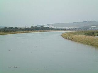
This straightened tidal stretch of the River Ouse just south of Lewes is called Cliffe Cut. It was made when the Ouse was canalised in the late 1790s. The original course of the river meandered in the foreground.
2810:
Apart from the initial section from its source to Ardingly, the channel is designated as heavily modified, because of the canalisation works. The water quality of the River Ouse system was as follows in 2019.
2540:
opened in 1846. Receipts in that year were about £800, a drop from around £1,200 in the 1810s, and despite significant reductions in tolls, traffic dwindled rapidly. The death-knell occurred in 1858, when the
1834:
and barge traffic continued using the river up to Lewes until the 1950s. Cross-Channel ferries still sail from the port. The river provides habitat for many varieties of fish, including unusually large
2632:. Seeds were crushed by edge rolling millstones, and then held in linen bags to be beaten by trip hammers. The process was initially powered by waterwheel, but subsequently a 28 hp (21 kW)
2449:, who had a seat on the committee by 1823. The navigation reached its greatest extent of 22.5 miles (36.2 km) in 1812, when Wells constructed a further extension to Upper Ryelands Bridge at
1810:
surveyed the river in 1788, and produced proposals to canalise the upper river above Lewes, and to radically improve the lower river. The Proprietors of the River Ouse Navigation were created by
2186:
would include a new cut some 1,000 yards (910 m) long, and would cost an additional £1,980, which included the cost of a towpath from Lewes to Piddinghoe, just to the north of Newhaven.
2177:
feet (13.7 by 3.7 m), which could carry 30 tons. The work would involve easing sharp curves, widening the channel in places, making cuts to straighten some sections, and constructing 25
1802:
In 1539, a new channel for the entrance to the river was cut through the shingle bar, and meadows flourished for a time, but flooding returned and meadows reverted to marshland. The engineer
5007:
2102:, some 2 miles (3.2 km) from its position in Roman times. The bar prevented the river from draining effectively, and made it difficult for ships to enter the estuary. Prior Crowham of
2675:
by a siding. Some of the buildings remained in use for various purposes until the end of the Secord World War, but virtually nothing remains of what was the largest water mill in Sussex.
2430:. c. cxxii) on 12 June 1806, which allowed them to raise another £30,000, and to abandon plans to proceed beyond Hammer Bridge. With new motivation, the Proprietors found an engineer in
4717:
2165:. Smeaton's plan for a sluice and navigation lock at Piddinghoe had not been carried out, and the river remained free of tolls. The preamble to the River Ouse Navigation Act 1790 (
2536:
at Haywards Heath. There is some evidence that goods were carried up the navigation and transferred to the railway, but this practice was short lived, as the coastal railway from
307:
2637:
Mill. The cost of the repairs was estimated to be between £7,000 and £8,000, but the mill was rebuilt and continued trading. When offered for sale in 1880, it could produce 80
4109:
2053:. It is presumed that its valley was cut during a glacial period, since it forms the remnant of a much larger river system that once flowed onto the floor of what is now the
1919:
Below Isfield, the narrow valley widens out into a broad flood plain, and the river is joined by the Longford Stream, the Iron River and the Bevern Stream, before it reaches
4087:
2755:, which are a species under threat on an international scale. The tidal stretches contain fish that can tolerate the lower levels of salt found in brackish water, including
2936:
presence of polybrominated diphenyl ethers (PBDE), perfluorooctane sulphonate (PFOS) and mercury compounds, none of which had previously been included in the assessment.
5114:
3145:
4924:
2786:
Several studies into the presence and effects of organic and inorganic pollutants in the Sussex Ouse have been carried out, including one on the effects of
2070:
by the 14th century the Ouse valley was regularly flooding in winter, and frequently the waters remained on the lower meadows through the summer. In 1422 a
4671:
2667:
2453:, with similar payment terms to his previous contract. There was a 0.75-mile (1.2 km) branch to Shortbridge, and some shorter branches. There were 19
1931:
traverse greensand and clay before they reach the Ouse. Below the weirs of Barcombe, the river is partially tidal, and forms large meanders, with numerous
2532:
was built. Initially, this provided some trade, as 11 million bricks from the Netherlands were transported along the Ouse for the construction of the
2442:
300:
4996:
3899:
4905:
4446:
2650:
several villages to the north. The owners at the time were Thomas Rickman & Son, who also owned Barcombe Oil Mill. A siding from the mill to
4973:
3066:
3022:
2960:, was published in 2011; walking the length of the Ouse, Laing reflects upon Woolf's life and upon the relationship between history and place.
2381:
2289:
2232:
5079:
5060:
5027:
4887:
4868:
4849:
4830:
4811:
4765:
2446:
2807:
and fish. Chemical status, which compares the concentrations of various chemicals against known safe concentrations, is rated good or fail.
293:
2979:
2782:
2537:
1844:
1822:. Trustees and the Commissioners of the Lewes and Laughton Levels jointly managed the work on the lower river, and the agriculturalist
3399:
3340:
3232:
2083:'s meadow at Southerham were converted into a permanent fishery (the Brodewater) in the mid-15th century, and by the 1530s the entire
236:
1743:
3592:
3394:
3335:
3227:
3044:
2666:
The final mill was Bishopstone Tide Mill, located a little to the east of the present mouth of the river. The Duke of Newcastle,
2373:
2076:
4014:
5109:
5104:
3948:
2651:
2508:
2504:
1893:
803:
4935:
Peck, Mika; et al. (5 November 2009). "Sediments are major sinks of steroidal estrogens in two United Kingdom rivers".
4744:
2465:
155:
4987:
4065:
1916:, where fast-flowing small streams cut deep valleys through woods, and flow over underlying beds of sandstones and clays.
4244:
2990:
3177:
4696:
4207:
2519:
3281:
2529:
2270:
2213:
2330:. c. 52) was obtained on 28 April 1790, covering improvements to the river between Lewes Bridge and Hammer Bridge in
4917:
1912:. Most of the tributaries are in the upper catchment that have joined it originate in the heaths and forests of the
5041:
2583:
2431:
2084:
2037:
1783:
1563:
1398:
950:
848:
325:
4667:
3303:
2495:
breakwater, until the tracks were lifted in 1963. For many years the locomotive used on the tramway was No. 72
2080:
1469:
540:
393:
4641:
4615:
4589:
4563:
4537:
2974:
2969:
2671:
2567:
2409:
2178:
5070:
Woodcock, A. (2003). "The archaeological implications of coastal change in Sussex". In Rudling, D. (ed.).
2748:
2559:
2182:
1881:
1848:
632:
88:
3254:
4472:
4134:
3618:
2700:
2450:
2278:
2221:
2112:
2020:
1987:
1819:
1767:
1592:
1569:
218:
108:
20:
4898:
4453:
1847:
because of its wide variety of invertebrates. Walkers can follow the course of the river by using the
4110:"Environment Agency proposals for the Ouse, Cuckmere and Pevensey Levels Internal Drainage Districts"
3438:
2099:
2071:
4684:
3070:
3018:
2740:
2533:
2435:
2033:
1991:
419:
4511:
2739:
have appeared in the river at and upstream of Lewes. Rarer breeds which inhabit the river include
4960:
1865:
1446:
1375:
825:
518:
423:
2790:
entering the river from Sewage Treatment Works outfalls on the reproductive physiology of fish.
1806:
proposed a solution for the drainage of the valley in 1767, but it was only partly implemented.
5075:
5056:
5023:
5020:
A Biographical Dictionary of Civil Engineers in Great Britain and Ireland: Vol 1: 1500 to 1830
4981:
4952:
4883:
4864:
4845:
4826:
4807:
4761:
2756:
2752:
2028:
1999:, each opening causes significant traffic congestion. Below the bridge, the river becomes the
1811:
2169:. c. 52) indicated that the river was only used from the sea to Barcombe Mills at that time.
4944:
4788:
4399:
3390:
3331:
3223:
2659:
installed in the 1960s, which is used to force water downstream when the river is in spate.
2582:. When the water companies were privatised in 1989, rivers became the responsibility of the
2500:
2024:
2000:
1924:
1897:
1831:
1729:
1621:
799:
37:
4039:
1818:. c. 52), and eventually built 19 locks, to enable boats to reach Upper Ryelands Bridge at
4485:
3631:
2575:
2563:
2091:
2054:
2008:
2007:
in France, a service which has been running since 1847. Finally, the river flows into the
1951:
1796:
1694:
1520:
206:
3599:
3362:
4754:
2945:
2716:
2684:
2642:
2579:
2491:
2173:
1956:
1940:
1920:
1885:
1807:
1771:
1237:
4424:
5098:
2760:
2720:
2692:
2523:
The west breakwater prevents shingle from blocking the mouth of the river at Newhaven
2066:
1872:
1791:
1763:
1671:
137:
4964:
1786:, an area of flat, low-lying land that borders the river and another tributary, the
5037:
4512:"Glossary (see Biological quality element; Chemical status; and Ecological status)"
2953:
2800:
2778:
2772:
2736:
2704:
2699:, both of which can exceed 30 pounds (14 kg) in weight. Other species include
2542:
2399:
2307:
2136:
2103:
1983:
1979:. There are public pathways on both sides of the channel for most of this stretch.
1964:
1840:
1803:
1787:
1778:. It forms the main spine of an extensive network of smaller streams, of which the
1494:
1293:
1124:
4974:"Historical Account of the Navigable Rivers, Canals and Railways of Great Britain"
3956:
3460:
2135:
In 1767 the Commissioners for the Lewes and Laughton Levels employed the engineer
4736:
2744:
2732:
2712:
2708:
2688:
2633:
2629:
2571:
2482:
2050:
1932:
1889:
1876:
1836:
1823:
1759:
1755:
201:
74:
70:
3482:
2804:
2768:
2454:
2162:
1976:
1913:
3878:
251:
238:
170:
157:
2764:
2691:
that migrate up the river each year to spawn. There are also populations of
2427:
2386:
2343:
2331:
2327:
2294:
2237:
2166:
1996:
1972:
1905:
1861:
1815:
1779:
1766:
in West Sussex, and flows eastwards and then southwards to reach the sea at
1516:
1078:
900:
43:
4956:
4861:
The Rivers of Britain: Estuaries, Tideways, Havens, Lochs, Firths and Kyles
4377:
2087:
comprising over 6,000 acres (24 km), were reduced to marshland again.
2019:'Ouse' is a common name for rivers in England, with examples including the
4777:"The Origin of Newhaven and the Drainage of the Lewes and Laughton Levels"
4400:"Density and Dispersal of Introduced Pumpkinseed in Small English Streams"
2985:
286:
3202:
3105:
2787:
2638:
2107:
466:
100:
84:
2948:
drowned herself in the River Ouse on 28 March 1941, near the village of
2949:
2731:. The Sheffield and Batts Bridge tributaries have small populations of
2122:
1968:
1909:
1148:
1082:
96:
60:
2656:
2004:
1960:
1936:
1901:
1751:
1327:
956:
927:
92:
4793:
4776:
2079:
of 1421. Drainage became so bad that 400 acres (1.6 km) of the
2735:, which have escaped from on-line fish ponds, and since 2009 a few
1782:
is the main tributary. As it nears the coast it passes through the
4948:
2728:
2724:
2687:
that can be found in Britain. It is known for the unusually large
2518:
2464:
2121:
2095:
1947:
1775:
1424:
104:
1904:, it turns to the south and is joined by its main tributary, the
4943:(4). Society of Environmental Toxicology and Chemistry: 945–52.
2696:
2115:, which succeeded Seaford as the port at the mouth of the Ouse.
4135:"The River Ouse (Sussex) Internal Drainage District Order 2016"
4066:"The Commissioners of Sewers for the Lewes and Laughton Levels"
2098:
across the river mouth, which had gradually moved eastwards to
1839:
that swim up the river to spawn in the higher tributaries. The
1732:
3526:
3524:
2469:
Southease swing bridge dates from 1880. It no longer opens.
222:
141:
3691:
3689:
2011:, surrounded on either side by two long breakwater piers.
1750:) is a 35 miles (56 kilometres) long river in the English
3861:
3859:
3810:
3808:
3795:
3793:
3421:
3419:
3417:
3178:"South East Water Cryptosporidium Inactivation Projects"
2049:
The Ouse is one of the four rivers that cut through the
4823:
Georgian Lewes 1714-1830: The Heyday of a Country Town
4685:
New York Times, "On This Day": Mrs. Woolf's Body Found
4015:"Shoreham Cement Works Collaborative planning project"
3780:
3778:
3776:
2683:
The river provides habitat for most of the species of
2952:; her body was recovered from the river on 18 April.
2036:, meaning "Water river" or "Wet river". However, the
1860:
The River Ouse, together with its main tributary the
1744:
1735:
42:
View looking north towards Cliffe at high tide from
2408:
2398:
2393:
2380:
2354:
2306:
2301:
2288:
2277:
2251:
2231:
2220:
2194:
277:
267:
228:
212:
200:
186:
147:
131:
123:
114:
80:
66:
56:
51:
30:
4753:
4701:, The Telegraph, May 11, 2011. Retrieved 27-06-18.
2003:, where there is a ferry terminal for sailings to
1908:, flowing in from the north east, before reaching
4088:"Internal Drainage Districts in southern England"
2566:, with the land drainage functions handled by an
4213:. GeoSmart Information. October 2009. p. 34
4208:"Lewes District Strategic Flood Risk Assessment"
3542:
2434:, the geologist who had formerly worked for the
1790:. It was a large tidal inlet at the time of the
3135:Ordnance Survey, 1:25,000 map and 1:50,000 map.
4997:"Chapter 3. The Sussex Coast Past and Present"
4115:. East Sussex CC. 14 September 2015. p. 2
4020:. Hargreaves Group. 8 October 2013. p. 50
2090:Part of the problem of flooding was caused by
1946:The tidal river continues through the town of
4976:. Archived from the original on 3 March 2016.
4564:"Ouse Ardingly to confluence with Scrase Brk"
3591:The Conservation Studio, Cirencester (2007).
301:
8:
4743:. Sussex Industrial Archaeological Society.
4718:"River Ouse Catchment Flood Management Plan"
4364:
4352:
4328:
4316:
4304:
4292:
4280:
4268:
4250:. Sussex Ouse Restoration Trust. Spring 2018
3566:
3385:
3383:
2856:Ouse Ardingly to confluence with Scrase Brk
4842:Inland Waterways of Great Britain (8th Ed.)
4231:
4052:
2999:Ouse and Uck. Sketch of a Sussex Catchment.
2958:To the River: A Journey Beneath the Surface
5004:Sussex: Environment, Landscape and Society
4880:The Canals of South and South East England
4538:"Ouse from Slaugham to Ardingly Reservoir"
2441:The proprietors then faced a dispute with
2351:
2248:
2191:
333:
308:
294:
4792:
3932:
3920:
3838:
3826:
3425:
2837:Ouse from Slaugham to Ardingly Reservoir
5018:Skempton, Sir Alec; et al. (2002).
4001:
3977:
3865:
3850:
3814:
3799:
3695:
3593:"Piddinghoe Conservation Area Appraisal"
3530:
3395:"Swing bridge over River Ouse (1393389)"
3069:. Sussex Flow Initiative. Archived from
3001:Essedon Press, Wych Cross, East Sussex.
2813:
623:
5115:River navigations in the United Kingdom
5046:. Longman, Hurst, Rees, Orme and Brown.
4995:Robinson, D A; Williams, R B G (1983).
4930:from the original on 22 September 2015.
3949:"History of the Sussex Ouse Navigation"
3943:
3941:
3767:
3755:
3743:
3731:
3719:
3707:
3680:
3668:
3656:
3644:
3578:
3554:
3151:. Archaeology Data Service. p. 1.
3131:
3129:
3127:
3125:
3123:
3010:
2422:River Ouse Navigation (Sussex) Act 1806
2356:River Ouse Navigation (Sussex) Act 1806
1830:On the lower river, Newhaven became an
445:Former limit of navigation (1812-1861)
291:
4979:
4937:Environmental Toxicology and Chemistry
4741:Sussex Main Lines - A Year 2002 Survey
4481:
4470:
4170:
4158:
3627:
3616:
3515:
3336:"Bridge over the River Ouse (1353014)"
3100:
3098:
3096:
3094:
3092:
3090:
3088:
1868:has a responsibility for maintenance.
1814:, the River Ouse Navigation Act 1790 (
1583:
1415:
27:
5051:Stidder, Derek; Smith, Colin (1997).
3784:
3228:"Parish Church of St Peter (1222114)"
3158:from the original on 23 November 2021
3025:from the original on 23 November 2021
2410:Text of statute as originally enacted
1967:joins from the east, and then passes
7:
5043:Miscellaneous Papers of John Smeaton
4698:To The River by Olivia Laing: review
4498:
4447:"SSSI Citation — Lewes Brooks"
4340:
3989:
1959:. The Ouse continues southeast past
1880:south east, passing to the north of
5072:The Archaeology of Sussex to AD2000
4911:from the original on 23 April 2018.
4747:from the original on 26 April 2018.
4674:from the original on 14 March 2024.
4427:. Ouse Angling Preservation Society
4380:. Ouse Angling Preservation Society
4194:
4182:
3503:
2980:History of the British canal system
2783:Site of Special Scientific Interest
2227:Fletching, in the County of Sussex.
1845:Site of Special Scientific Interest
1227:
816:
19:For other rivers named "Ouse", see
5074:. Heritage, University of Sussex.
5013:from the original on 12 July 2018.
4730:from the original on 25 July 2019.
3400:National Heritage List for England
3341:National Heritage List for England
3233:National Heritage List for England
3146:"Defence Area 23 - Barcombe Mills"
3045:"River Ouse: Projects and Actions"
2888:10.55 square miles (27.3 km)
2849:14.49 square miles (37.5 km)
999:
940:
838:
456:
383:
14:
4844:. Imray Laurie Norie and Wilson.
4781:Sussex Archaeological Collections
4452:. Natural England. Archived from
4140:. Stationery Office. 18 July 2016
3953:The Sussex Ouse Restoration Trust
3280:Merchant, Barbara (August 2015).
2868:4.66 square miles (12.1 km)
1612:
1366:
1161:
1138:
1095:
1069:
1019:
509:
4616:"Ouse between Isfield and Coast"
3106:"The Sussex River Ouse Corridor"
2984:
2908:0.99 square miles (2.6 km)
2562:, most rivers were managed by a
2374:Parliament of the United Kingdom
2367:
2264:
2207:
1728:
1683:
1661:
1655:
1654:
1634:
1611:
1605:
1604:
1582:
1553:
1552:
1532:
1507:
1506:
1485:
1484:
1459:
1458:
1436:
1414:
1388:
1387:
1365:
1346:
1339:
1313:
1307:
1306:
1283:
1277:
1276:
1257:
1256:
1249:
1226:
1204:
1203:
1181:
1180:
1160:
1137:
1115:
1114:
1094:
1068:
1046:
1045:
1025:
1018:
998:
991:
969:
968:
939:
914:
913:
888:
887:
865:
864:
837:
815:
790:
789:
782:
760:
759:
737:
736:
714:
713:
691:
690:
668:
667:
645:
644:
622:
600:
599:
577:
576:
554:
553:
531:
530:
508:
502:
501:
479:
478:
455:
435:
409:
382:
362:
343:
342:
36:
3879:"River Ouse Navigation, Sussex"
2896:Ouse between Isfield and Coast
2546:on the Lower Ouse below Lewes.
1635:
1533:
1404:Phoenix Causeway Bridge, Lewes
1340:
1284:
1250:
1026:
783:
436:
410:
4923:. Ouse and Adur Rivers Trust.
4756:Railway of the Southern Region
4245:"What Direction Next For SORT"
2799:the quantity and varieties of
2652:Barcombe Mills railway station
2338:Lower Ouse Navigation Act 1791
2322:River Ouse Navigation Act 1790
2253:Lower Ouse Navigation Act 1791
2196:River Ouse Navigation Act 1790
1894:Sheffield Park railway station
1852:Trust is opposed to the idea.
1437:
1216:Barcombe Mill Locks and weirs
992:
363:
230: • coordinates
149: • coordinates
1:
4904:. National Rivers Authority.
4802:Brandon, P; Short, B (1990).
3183:. Water Projects Online. 2014
1990:, where it splits industrial
1684:
1347:
115:Physical characteristics
5055:. Vol. 1. Baron Birch.
4737:"Keymer Junction To Seaford"
4670:. Environment Agency. 2023.
3543:Robinson & Williams 1983
3485:. The Free Dictionary Online
3203:"The Anchor Inn and boating"
3108:. Ouse and Adur Rivers Trust
2997:Prendergast, H.D.V. (2019).
2152:sluice was not constructed.
1662:
1314:
317:River Ouse, Sussex route map
269: • elevation
188: • elevation
4804:The South-East from AD 1000
3461:"About Newhaven ferry port"
3047:. Adur and Ouse Partnership
2530:London and Brighton Railway
2271:Parliament of Great Britain
2214:Parliament of Great Britain
214: • location
133: • location
5131:
4972:Priestley, Joseph (1831).
4878:Hadfield, Charles (1969).
4840:Cumberlidge, Jane (2009).
3255:"Eco-disaster on the Ouse"
3067:"The River Ouse catchment"
2349:United Kingdom legislation
2318:An act of Parliament, the
2246:United Kingdom legislation
2189:United Kingdom legislation
18:
5002:. In Sutton, Alan (ed.).
4986:: CS1 maint: unfit URL (
4863:. Adlard Coles Nautical.
3441:. Newhaven Port Authority
3282:"The Malling Footbridges"
2885:9.2 miles (14.8 km)
2846:6.9 miles (11.1 km)
2584:National Rivers Authority
2366:
2361:
2263:
2258:
2206:
2201:
2085:Lewes and Laughton Levels
2038:National Rivers Authority
1963:, where the tributary of
1784:Lewes and Laughton Levels
1692:
1677:
1670:
1648:
1643:
1628:
1620:
1598:
1591:
1576:
1561:
1546:
1541:
1526:
1515:
1500:
1493:
1478:
1467:
1452:
1445:
1430:
1423:
1408:
1396:
1381:
1374:
1359:
1355:
1333:
1325:
1300:
1292:
1270:
1265:
1243:
1235:
1220:
1215:
1197:
1192:
1174:
1169:
1154:
1146:
1131:
1123:
1108:
1103:
1088:
1077:
1062:
1057:
1039:
1034:
1012:
1007:
985:
980:
962:
948:
933:
925:
907:
899:
881:
876:
858:
846:
831:
824:
809:
798:
776:
771:
753:
748:
730:
725:
707:
702:
684:
679:
661:
656:
638:
631:
616:
611:
593:
588:
570:
565:
547:
539:
524:
517:
495:
490:
472:
464:
449:
444:
429:
418:
403:
391:
376:
372:Slaugham Place Mill Pond
371:
356:
351:
336:
196:
119:
35:
4735:Blackwell, John (2002).
4365:Stidder & Smith 1997
4353:Stidder & Smith 1997
4329:Stidder & Smith 1997
4317:Stidder & Smith 1997
4305:Stidder & Smith 1997
4293:Stidder & Smith 1997
4281:Stidder & Smith 1997
4269:Stidder & Smith 1997
4042:. Ordnance Survey. 1875.
3567:Brandon & Short 1990
3439:"Swingbridge Procedures"
3021:. Sussex Angling Media.
2905:2.4 miles (3.9 km)
2865:4.5 miles (7.2 km)
2622:Sussex Weekly Advertiser
2580:Southern Water Authority
2558:With the passing of the
2443:the first Lord Sheffield
2081:Archbishop of Canterbury
1982:At Southease there is a
1900:. After skirting around
1843:area of the levels is a
1644:Newhaven Ferry Terminal
281:35 miles / 56 kilometres
16:River in Sussex, England
4859:Fisher, Stuart (2012).
4775:Brandon, P. F. (1971).
4752:Body, Geoffrey (1989).
4646:Catchment Data Explorer
4620:Catchment Data Explorer
4594:Catchment Data Explorer
4568:Catchment Data Explorer
4542:Catchment Data Explorer
4516:Catchment Data Explorer
3902:. Ordnance Survey. 1875
3483:"Ouse River Definition"
2975:Canals of Great Britain
2970:Rivers of Great Britain
2568:internal drainage board
2499:, now preserved on the
2061:Inundation and drainage
465:Upper Ryelands Bridge,
192:85 m (279 ft)
4723:. Environment Agency.
4480:Cite journal requires
3626:Cite journal requires
2560:Land Drainage Act 1930
2524:
2507:on the upper river to
2470:
2172:In 1788, the engineer
2130:
2127:
2023:in Yorkshire, and the
1849:Sussex Ouse Valley Way
252:50.784217°N 0.057995°E
171:51.038875°N 0.234315°W
5110:Rivers of East Sussex
5105:Rivers of West Sussex
5006:. Sussex University.
4882:. David and Charles.
4825:. Colin Brent Books.
4821:Brent, Colin (1993).
4331:, pp. 22, 36–37.
4319:, pp. 22, 35–36.
4283:, pp. 26, 41–42.
3463:. Newhaven Ferry Port
3284:. Lewes History Group
2522:
2468:
2447:second Lord Sheffield
2240:. c. 52 28 April 1790
2125:
1892:just before reaching
1871:The river rises near
5053:Watermills of Sussex
4916:OART (Winter 2015).
4897:NRA (October 1991).
4760:. Patrick Stephens.
4648:. Environment Agency
4622:. Environment Agency
4596:. Environment Agency
4570:. Environment Agency
4544:. Environment Agency
4518:. Environment Agency
4425:"Non-Native Species"
4090:. Environment Agency
3841:, pp. 487, 490.
3367:Railway Land Project
3363:"The Nature Reserve"
3304:"Sussex EUS – Lewes"
2993:at Wikimedia Commons
2679:Ecology and wildlife
2641:of oil cake and 200
2077:St Elizabeth's flood
2072:Commission of Sewers
541:Ardingly branch line
273:0 m (0 ft)
176:51.038875; -0.234315
4234:, pp. 238–239.
4068:. National Archives
3935:, pp. 489–490.
3829:, pp. 487–488.
3722:, pp. 340–341.
3605:on 13 February 2012
3569:, pp. 107–108.
2534:Ouse Valley Viaduct
2436:Somerset Coal Canal
1774:and passes through
1693:Mouth of the Ouse,
1035:Shortbridge Branch
981:Sharps Bridge Lock
703:Henfield Wood Lock
680:East Mascalls Lock
420:Ouse Valley Viaduct
352:Source of the Ouse
257:50.784217; 0.057995
248: /
167: /
5022:. Thomas Telford.
4459:on 30 October 2008
3959:on 6 December 2004
3770:, p. 350-352.
3758:, p. 343-344.
3545:, p. 3 (pdf).
2991:River Ouse, Sussex
2695:and more recently
2525:
2503:, which runs from
2471:
2128:
1866:Environment Agency
1565: A259
1447:East Coastway line
1400: A277
1376:Greenwich Meridian
1296:, disused railway
1127:, disused railway
952: A272
850: A275
826:Greenwich Meridian
612:Fulling Mill Lock
519:Ardingly Reservoir
424:Brighton Main Line
5081:978-0-9544456-1-4
5062:978-0-86023-569-9
5029:978-0-7277-2939-2
4889:978-0-7153-4693-8
4870:978-1-4081-4656-9
4851:978-1-84623-010-3
4832:978-0-9522423-0-7
4813:978-0-582-49245-5
4767:978-1-85260-297-0
4668:"Chemical Status"
4367:, pp. 39–40.
4307:, pp. 31–32.
3980:, pp. 33–34.
3853:, pp. 32–33.
2989:Media related to
2933:
2932:
2929:heavily modified
2911:heavily modified
2891:heavily modified
2871:heavily modified
2820:Ecological Status
2543:Lewes to Uckfield
2538:Brighton to Lewes
2415:
2414:
2362:Act of Parliament
2316:
2315:
2259:Act of Parliament
2244:
2243:
2202:Act of Parliament
1896:on the preserved
1888:. It passes into
1812:act of Parliament
1720:
1719:
1716:
1715:
1471: A27
926:Goldbridge Lock,
854:Sheffield Bridge
395: A23
285:
284:
5122:
5085:
5066:
5047:
5033:
5014:
5012:
5001:
4991:
4985:
4977:
4968:
4931:
4929:
4922:
4912:
4910:
4903:
4899:"The River Ouse"
4893:
4874:
4855:
4836:
4817:
4798:
4796:
4771:
4759:
4748:
4731:
4729:
4722:
4702:
4693:
4687:
4682:
4676:
4675:
4664:
4658:
4657:
4655:
4653:
4638:
4632:
4631:
4629:
4627:
4612:
4606:
4605:
4603:
4601:
4586:
4580:
4579:
4577:
4575:
4560:
4554:
4553:
4551:
4549:
4534:
4528:
4527:
4525:
4523:
4508:
4502:
4496:
4490:
4489:
4483:
4478:
4476:
4468:
4466:
4464:
4458:
4451:
4443:
4437:
4436:
4434:
4432:
4421:
4415:
4414:
4412:
4410:
4404:
4396:
4390:
4389:
4387:
4385:
4378:"Coarse fishing"
4374:
4368:
4362:
4356:
4350:
4344:
4338:
4332:
4326:
4320:
4314:
4308:
4302:
4296:
4290:
4284:
4278:
4272:
4266:
4260:
4259:
4257:
4255:
4249:
4241:
4235:
4232:Cumberlidge 2009
4229:
4223:
4222:
4220:
4218:
4212:
4204:
4198:
4192:
4186:
4180:
4174:
4168:
4162:
4156:
4150:
4149:
4147:
4145:
4139:
4131:
4125:
4124:
4122:
4120:
4114:
4106:
4100:
4099:
4097:
4095:
4084:
4078:
4077:
4075:
4073:
4062:
4056:
4053:Cumberlidge 2009
4050:
4044:
4043:
4036:
4030:
4029:
4027:
4025:
4019:
4011:
4005:
3999:
3993:
3987:
3981:
3975:
3969:
3968:
3966:
3964:
3955:. Archived from
3945:
3936:
3930:
3924:
3918:
3912:
3911:
3909:
3907:
3896:
3890:
3889:
3887:
3885:
3875:
3869:
3863:
3854:
3848:
3842:
3836:
3830:
3824:
3818:
3812:
3803:
3797:
3788:
3782:
3771:
3765:
3759:
3753:
3747:
3741:
3735:
3729:
3723:
3717:
3711:
3705:
3699:
3693:
3684:
3678:
3672:
3666:
3660:
3654:
3648:
3642:
3636:
3635:
3629:
3624:
3622:
3614:
3612:
3610:
3604:
3598:. Archived from
3597:
3588:
3582:
3576:
3570:
3564:
3558:
3552:
3546:
3540:
3534:
3533:, pp. 1–16.
3528:
3519:
3513:
3507:
3501:
3495:
3494:
3492:
3490:
3479:
3473:
3472:
3470:
3468:
3457:
3451:
3450:
3448:
3446:
3435:
3429:
3423:
3412:
3411:
3409:
3407:
3391:Historic England
3387:
3378:
3377:
3375:
3373:
3359:
3353:
3352:
3350:
3348:
3332:Historic England
3328:
3322:
3321:
3319:
3317:
3311:Lewes-Eastbourne
3308:
3300:
3294:
3293:
3291:
3289:
3277:
3271:
3270:
3268:
3266:
3261:. 27 August 2001
3251:
3245:
3244:
3242:
3240:
3224:Historic England
3220:
3214:
3213:
3211:
3209:
3199:
3193:
3192:
3190:
3188:
3182:
3174:
3168:
3167:
3165:
3163:
3157:
3150:
3142:
3136:
3133:
3118:
3117:
3115:
3113:
3102:
3083:
3082:
3080:
3078:
3073:on 18 April 2018
3063:
3057:
3056:
3054:
3052:
3041:
3035:
3034:
3032:
3030:
3015:
2988:
2814:
2501:Bluebell Railway
2424:
2423:
2371:
2370:
2357:
2352:
2340:
2339:
2324:
2323:
2268:
2267:
2254:
2249:
2211:
2210:
2197:
2192:
2131:Smeaton's survey
2094:creating a huge
2001:Port of Newhaven
1925:South East Water
1898:Bluebell Railway
1762:. It rises near
1747:
1742:
1741:
1738:
1737:
1734:
1687:
1686:
1665:
1664:
1658:
1657:
1638:
1637:
1622:Port of Newhaven
1615:
1614:
1608:
1607:
1586:
1585:
1568:
1566:
1556:
1555:
1536:
1535:
1510:
1509:
1488:
1487:
1474:
1472:
1462:
1461:
1440:
1439:
1418:
1417:
1403:
1401:
1391:
1390:
1369:
1368:
1350:
1349:
1343:
1342:
1317:
1316:
1310:
1309:
1287:
1286:
1280:
1279:
1260:
1259:
1253:
1252:
1230:
1229:
1207:
1206:
1184:
1183:
1164:
1163:
1141:
1140:
1118:
1117:
1104:Longford Stream
1098:
1097:
1072:
1071:
1049:
1048:
1029:
1028:
1022:
1021:
1002:
1001:
995:
994:
972:
971:
955:
953:
943:
942:
917:
916:
891:
890:
868:
867:
853:
851:
841:
840:
819:
818:
800:Bluebell Railway
793:
792:
786:
785:
772:Bacon Wish Lock
763:
762:
740:
739:
726:Freshwater Lock
717:
716:
694:
693:
671:
670:
648:
647:
626:
625:
603:
602:
580:
579:
557:
556:
534:
533:
512:
511:
505:
504:
491:Riverswood Lock
482:
481:
459:
458:
439:
438:
413:
412:
398:
396:
386:
385:
366:
365:
346:
345:
334:
310:
303:
296:
287:
263:
262:
260:
259:
258:
253:
249:
246:
245:
244:
241:
189:
182:
181:
179:
178:
177:
172:
168:
165:
164:
163:
160:
150:
134:
40:
28:
5130:
5129:
5125:
5124:
5123:
5121:
5120:
5119:
5095:
5094:
5093:
5088:
5082:
5069:
5063:
5050:
5036:
5030:
5017:
5010:
4999:
4994:
4978:
4971:
4934:
4927:
4920:
4915:
4908:
4901:
4896:
4890:
4877:
4871:
4858:
4852:
4839:
4833:
4820:
4814:
4801:
4794:10.5284/1086029
4774:
4768:
4751:
4734:
4727:
4720:
4716:Agency (2009).
4715:
4711:
4706:
4705:
4695:Hoare, Philip,
4694:
4690:
4683:
4679:
4666:
4665:
4661:
4651:
4649:
4640:
4639:
4635:
4625:
4623:
4614:
4613:
4609:
4599:
4597:
4588:
4587:
4583:
4573:
4571:
4562:
4561:
4557:
4547:
4545:
4536:
4535:
4531:
4521:
4519:
4510:
4509:
4505:
4497:
4493:
4479:
4469:
4462:
4460:
4456:
4449:
4445:
4444:
4440:
4430:
4428:
4423:
4422:
4418:
4408:
4406:
4402:
4398:
4397:
4393:
4383:
4381:
4376:
4375:
4371:
4363:
4359:
4351:
4347:
4339:
4335:
4327:
4323:
4315:
4311:
4303:
4299:
4291:
4287:
4279:
4275:
4267:
4263:
4253:
4251:
4247:
4243:
4242:
4238:
4230:
4226:
4216:
4214:
4210:
4206:
4205:
4201:
4193:
4189:
4181:
4177:
4169:
4165:
4157:
4153:
4143:
4141:
4137:
4133:
4132:
4128:
4118:
4116:
4112:
4108:
4107:
4103:
4093:
4091:
4086:
4085:
4081:
4071:
4069:
4064:
4063:
4059:
4051:
4047:
4038:
4037:
4033:
4023:
4021:
4017:
4013:
4012:
4008:
4000:
3996:
3988:
3984:
3976:
3972:
3962:
3960:
3947:
3946:
3939:
3931:
3927:
3919:
3915:
3905:
3903:
3898:
3897:
3893:
3883:
3881:
3877:
3876:
3872:
3864:
3857:
3849:
3845:
3837:
3833:
3825:
3821:
3813:
3806:
3798:
3791:
3783:
3774:
3766:
3762:
3754:
3750:
3742:
3738:
3730:
3726:
3718:
3714:
3706:
3702:
3694:
3687:
3679:
3675:
3667:
3663:
3655:
3651:
3643:
3639:
3625:
3615:
3608:
3606:
3602:
3595:
3590:
3589:
3585:
3577:
3573:
3565:
3561:
3553:
3549:
3541:
3537:
3529:
3522:
3514:
3510:
3506:, pp. 1–2.
3502:
3498:
3488:
3486:
3481:
3480:
3476:
3466:
3464:
3459:
3458:
3454:
3444:
3442:
3437:
3436:
3432:
3424:
3415:
3405:
3403:
3389:
3388:
3381:
3371:
3369:
3361:
3360:
3356:
3346:
3344:
3330:
3329:
3325:
3315:
3313:
3306:
3302:
3301:
3297:
3287:
3285:
3279:
3278:
3274:
3264:
3262:
3253:
3252:
3248:
3238:
3236:
3222:
3221:
3217:
3207:
3205:
3201:
3200:
3196:
3186:
3184:
3180:
3176:
3175:
3171:
3161:
3159:
3155:
3148:
3144:
3143:
3139:
3134:
3121:
3111:
3109:
3104:
3103:
3086:
3076:
3074:
3065:
3064:
3060:
3050:
3048:
3043:
3042:
3038:
3028:
3026:
3017:
3016:
3012:
3007:
2966:
2942:
2823:Chemical Status
2796:
2681:
2609:
2600:
2576:River Authority
2564:catchment board
2556:
2517:
2463:
2421:
2420:
2376:
2368:
2355:
2350:
2337:
2336:
2321:
2320:
2273:
2265:
2252:
2247:
2216:
2208:
2195:
2190:
2158:
2156:Ouse navigation
2133:
2092:longshore drift
2063:
2055:English Channel
2047:
2017:
2009:English Channel
1952:Grade II listed
1858:
1797:longshore drift
1745:
1731:
1727:
1695:English Channel
1688:
1666:
1659:
1639:
1616:
1609:
1587:
1564:
1562:
1557:
1537:
1521:South Downs Way
1511:
1489:
1470:
1468:
1463:
1441:
1419:
1399:
1397:
1392:
1370:
1351:
1344:
1323:
1318:
1311:
1288:
1281:
1261:
1254:
1231:
1213:
1208:
1190:
1185:
1165:
1142:
1119:
1099:
1073:
1055:
1050:
1030:
1023:
1003:
996:
978:
973:
951:
949:
944:
923:
918:
897:
892:
877:Iron Gate Lock
874:
869:
849:
847:
842:
820:
794:
787:
769:
764:
746:
741:
723:
718:
700:
695:
677:
672:
654:
649:
627:
609:
604:
586:
581:
563:
558:
535:
513:
506:
488:
483:
460:
440:
414:
394:
392:
387:
367:
347:
328:
319:
318:
314:
270:
256:
254:
250:
247:
242:
239:
237:
235:
234:
231:
221:, East Sussex,
215:
207:English Channel
187:
175:
173:
169:
166:
161:
158:
156:
154:
153:
148:
140:, West Sussex,
132:
47:
24:
17:
12:
11:
5:
5128:
5126:
5118:
5117:
5112:
5107:
5097:
5096:
5092:
5091:External links
5089:
5087:
5086:
5080:
5067:
5061:
5048:
5034:
5028:
5015:
4992:
4969:
4932:
4913:
4894:
4888:
4875:
4869:
4856:
4850:
4837:
4831:
4818:
4812:
4799:
4772:
4766:
4749:
4732:
4712:
4710:
4707:
4704:
4703:
4688:
4677:
4659:
4633:
4607:
4581:
4555:
4529:
4503:
4491:
4482:|journal=
4438:
4416:
4391:
4369:
4357:
4345:
4333:
4321:
4309:
4297:
4285:
4273:
4261:
4236:
4224:
4199:
4187:
4175:
4163:
4151:
4126:
4101:
4079:
4057:
4055:, p. 238.
4045:
4031:
4006:
3994:
3992:, p. 141.
3982:
3970:
3937:
3933:Priestley 1831
3925:
3923:, p. 489.
3921:Priestley 1831
3913:
3891:
3870:
3855:
3843:
3839:Priestley 1831
3831:
3827:Priestley 1831
3819:
3804:
3789:
3772:
3760:
3748:
3746:, p. 342.
3736:
3734:, p. 341.
3724:
3712:
3710:, p. 340.
3700:
3698:, p. 571.
3685:
3683:, p. 106.
3673:
3671:, p. 104.
3661:
3659:, p. 101.
3649:
3637:
3628:|journal=
3583:
3571:
3559:
3547:
3535:
3520:
3518:, p. 247.
3508:
3496:
3474:
3452:
3430:
3426:Blackwell 2002
3413:
3379:
3354:
3323:
3295:
3272:
3259:Sussex Express
3246:
3215:
3194:
3169:
3137:
3119:
3084:
3058:
3036:
3009:
3008:
3006:
3003:
2995:
2994:
2982:
2977:
2972:
2965:
2962:
2946:Virginia Woolf
2941:
2938:
2931:
2930:
2927:
2925:
2923:
2920:
2917:
2913:
2912:
2909:
2906:
2903:
2900:
2897:
2893:
2892:
2889:
2886:
2883:
2880:
2877:
2873:
2872:
2869:
2866:
2863:
2860:
2857:
2853:
2852:
2850:
2847:
2844:
2841:
2838:
2834:
2833:
2830:
2827:
2824:
2821:
2818:
2795:
2792:
2749:river lampreys
2680:
2677:
2608:
2605:
2599:
2596:
2555:
2552:
2516:
2513:
2509:East Grinstead
2505:Sheffield Park
2492:William Cubitt
2462:
2459:
2413:
2412:
2406:
2405:
2402:
2396:
2395:
2391:
2390:
2384:
2378:
2377:
2372:
2364:
2363:
2359:
2358:
2348:
2314:
2313:
2310:
2304:
2303:
2299:
2298:
2292:
2286:
2285:
2281:
2275:
2274:
2269:
2261:
2260:
2256:
2255:
2245:
2242:
2241:
2235:
2229:
2228:
2224:
2218:
2217:
2212:
2204:
2203:
2199:
2198:
2188:
2174:William Jessop
2157:
2154:
2132:
2129:
2062:
2059:
2046:
2043:
2032:its name is a
2016:
2013:
1957:Heart of Reeds
1941:Grade I listed
1921:Barcombe Mills
1886:Haywards Heath
1857:
1854:
1832:important port
1808:William Jessop
1772:Haywards Heath
1718:
1717:
1714:
1713:
1711:
1709:
1707:
1705:
1703:
1701:
1698:
1697:
1691:
1689:
1682:
1680:
1678:
1675:
1674:
1669:
1667:
1660:
1653:
1651:
1649:
1646:
1645:
1642:
1640:
1633:
1631:
1629:
1626:
1625:
1619:
1617:
1610:
1603:
1601:
1599:
1596:
1595:
1590:
1588:
1581:
1579:
1577:
1574:
1573:
1560:
1558:
1551:
1549:
1547:
1544:
1543:
1542:Denton Island
1540:
1538:
1531:
1529:
1527:
1524:
1523:
1519:Swing Bridge,
1514:
1512:
1505:
1503:
1501:
1498:
1497:
1492:
1490:
1483:
1481:
1479:
1476:
1475:
1466:
1464:
1457:
1455:
1453:
1450:
1449:
1444:
1442:
1435:
1433:
1431:
1428:
1427:
1422:
1420:
1413:
1411:
1409:
1406:
1405:
1395:
1393:
1386:
1384:
1382:
1379:
1378:
1373:
1371:
1364:
1362:
1360:
1357:
1356:
1354:
1352:
1345:
1338:
1336:
1334:
1331:
1330:
1324:
1321:
1319:
1312:
1305:
1303:
1301:
1298:
1297:
1291:
1289:
1282:
1275:
1273:
1271:
1268:
1267:
1264:
1262:
1255:
1248:
1246:
1244:
1241:
1240:
1238:Barcombe Mills
1234:
1232:
1225:
1223:
1221:
1218:
1217:
1214:
1211:
1209:
1202:
1200:
1198:
1195:
1194:
1193:Oil Mill Lock
1191:
1188:
1186:
1179:
1177:
1175:
1172:
1171:
1170:Bevern Stream
1168:
1166:
1159:
1157:
1155:
1152:
1151:
1145:
1143:
1136:
1134:
1132:
1129:
1128:
1122:
1120:
1113:
1111:
1109:
1106:
1105:
1102:
1100:
1093:
1091:
1089:
1086:
1085:
1076:
1074:
1067:
1065:
1063:
1060:
1059:
1056:
1053:
1051:
1044:
1042:
1040:
1037:
1036:
1033:
1031:
1024:
1017:
1015:
1013:
1010:
1009:
1006:
1004:
997:
990:
988:
986:
983:
982:
979:
976:
974:
967:
965:
963:
960:
959:
947:
945:
938:
936:
934:
931:
930:
924:
921:
919:
912:
910:
908:
905:
904:
898:
895:
893:
886:
884:
882:
879:
878:
875:
872:
870:
863:
861:
859:
856:
855:
845:
843:
836:
834:
832:
829:
828:
823:
821:
814:
812:
810:
807:
806:
804:Sheffield Park
797:
795:
788:
781:
779:
777:
774:
773:
770:
767:
765:
758:
756:
754:
751:
750:
747:
744:
742:
735:
733:
731:
728:
727:
724:
721:
719:
712:
710:
708:
705:
704:
701:
698:
696:
689:
687:
685:
682:
681:
678:
675:
673:
666:
664:
662:
659:
658:
655:
652:
650:
643:
641:
639:
636:
635:
630:
628:
621:
619:
617:
614:
613:
610:
607:
605:
598:
596:
594:
591:
590:
589:Tester's Lock
587:
584:
582:
575:
573:
571:
568:
567:
566:Ryelands Lock
564:
561:
559:
552:
550:
548:
545:
544:
538:
536:
529:
527:
525:
522:
521:
516:
514:
507:
500:
498:
496:
493:
492:
489:
486:
484:
477:
475:
473:
470:
469:
463:
461:
454:
452:
450:
447:
446:
443:
441:
434:
432:
430:
427:
426:
417:
415:
408:
406:
404:
401:
400:
390:
388:
381:
379:
377:
374:
373:
370:
368:
361:
359:
357:
354:
353:
350:
348:
341:
339:
337:
330:
329:
324:
321:
320:
316:
315:
313:
312:
305:
298:
290:
283:
282:
279:
275:
274:
271:
268:
265:
264:
232:
229:
226:
225:
216:
213:
210:
209:
204:
198:
197:
194:
193:
190:
184:
183:
151:
145:
144:
135:
129:
128:
125:
121:
120:
117:
116:
112:
111:
82:
78:
77:
68:
64:
63:
58:
54:
53:
49:
48:
41:
33:
32:
15:
13:
10:
9:
6:
4:
3:
2:
5127:
5116:
5113:
5111:
5108:
5106:
5103:
5102:
5100:
5090:
5083:
5077:
5073:
5068:
5064:
5058:
5054:
5049:
5045:
5044:
5039:
5038:Smeaton, John
5035:
5031:
5025:
5021:
5016:
5009:
5005:
4998:
4993:
4989:
4983:
4975:
4970:
4966:
4962:
4958:
4954:
4950:
4949:10.1897/03-41
4946:
4942:
4938:
4933:
4926:
4919:
4914:
4907:
4900:
4895:
4891:
4885:
4881:
4876:
4872:
4866:
4862:
4857:
4853:
4847:
4843:
4838:
4834:
4828:
4824:
4819:
4815:
4809:
4806:. Routledge.
4805:
4800:
4795:
4790:
4786:
4782:
4778:
4773:
4769:
4763:
4758:
4757:
4750:
4746:
4742:
4738:
4733:
4726:
4719:
4714:
4713:
4708:
4700:
4699:
4692:
4689:
4686:
4681:
4678:
4673:
4669:
4663:
4660:
4647:
4643:
4637:
4634:
4621:
4617:
4611:
4608:
4595:
4591:
4590:"Middle Ouse"
4585:
4582:
4569:
4565:
4559:
4556:
4543:
4539:
4533:
4530:
4517:
4513:
4507:
4504:
4500:
4495:
4492:
4487:
4474:
4455:
4448:
4442:
4439:
4426:
4420:
4417:
4405:. CEFAS. 2005
4401:
4395:
4392:
4379:
4373:
4370:
4366:
4361:
4358:
4355:, p. 38.
4354:
4349:
4346:
4342:
4337:
4334:
4330:
4325:
4322:
4318:
4313:
4310:
4306:
4301:
4298:
4295:, p. 27.
4294:
4289:
4286:
4282:
4277:
4274:
4271:, p. 24.
4270:
4265:
4262:
4246:
4240:
4237:
4233:
4228:
4225:
4209:
4203:
4200:
4196:
4191:
4188:
4184:
4179:
4176:
4172:
4167:
4164:
4160:
4155:
4152:
4136:
4130:
4127:
4111:
4105:
4102:
4089:
4083:
4080:
4067:
4061:
4058:
4054:
4049:
4046:
4041:
4035:
4032:
4016:
4010:
4007:
4004:, p. 34.
4003:
4002:Hadfield 1969
3998:
3995:
3991:
3986:
3983:
3979:
3978:Hadfield 1969
3974:
3971:
3958:
3954:
3950:
3944:
3942:
3938:
3934:
3929:
3926:
3922:
3917:
3914:
3901:
3895:
3892:
3880:
3874:
3871:
3868:, p. 33.
3867:
3866:Hadfield 1969
3862:
3860:
3856:
3852:
3851:Hadfield 1969
3847:
3844:
3840:
3835:
3832:
3828:
3823:
3820:
3817:, p. 32.
3816:
3815:Hadfield 1969
3811:
3809:
3805:
3802:, p. 31.
3801:
3800:Hadfield 1969
3796:
3794:
3790:
3787:, p. 21.
3786:
3781:
3779:
3777:
3773:
3769:
3764:
3761:
3757:
3752:
3749:
3745:
3740:
3737:
3733:
3728:
3725:
3721:
3716:
3713:
3709:
3704:
3701:
3697:
3696:Skempton 2002
3692:
3690:
3686:
3682:
3677:
3674:
3670:
3665:
3662:
3658:
3653:
3650:
3647:, p. 99.
3646:
3641:
3638:
3633:
3620:
3601:
3594:
3587:
3584:
3581:, p. 98.
3580:
3575:
3572:
3568:
3563:
3560:
3557:, p. 96.
3556:
3551:
3548:
3544:
3539:
3536:
3532:
3531:Woodcock 2003
3527:
3525:
3521:
3517:
3512:
3509:
3505:
3500:
3497:
3484:
3478:
3475:
3462:
3456:
3453:
3440:
3434:
3431:
3427:
3422:
3420:
3418:
3414:
3402:
3401:
3396:
3392:
3386:
3384:
3380:
3368:
3364:
3358:
3355:
3343:
3342:
3337:
3333:
3327:
3324:
3312:
3305:
3299:
3296:
3283:
3276:
3273:
3260:
3256:
3250:
3247:
3235:
3234:
3229:
3225:
3219:
3216:
3204:
3198:
3195:
3179:
3173:
3170:
3154:
3147:
3141:
3138:
3132:
3130:
3128:
3126:
3124:
3120:
3107:
3101:
3099:
3097:
3095:
3093:
3091:
3089:
3085:
3072:
3068:
3062:
3059:
3046:
3040:
3037:
3024:
3020:
3014:
3011:
3004:
3002:
3000:
2992:
2987:
2983:
2981:
2978:
2976:
2973:
2971:
2968:
2967:
2963:
2961:
2959:
2955:
2951:
2947:
2939:
2937:
2928:
2926:
2924:
2921:
2918:
2915:
2914:
2910:
2907:
2904:
2901:
2898:
2895:
2894:
2890:
2887:
2884:
2881:
2878:
2875:
2874:
2870:
2867:
2864:
2861:
2858:
2855:
2854:
2851:
2848:
2845:
2842:
2839:
2836:
2835:
2831:
2828:
2825:
2822:
2819:
2816:
2815:
2812:
2808:
2806:
2802:
2801:invertebrates
2794:Water quality
2793:
2791:
2789:
2784:
2780:
2776:
2774:
2770:
2766:
2762:
2758:
2754:
2750:
2746:
2742:
2738:
2734:
2730:
2726:
2722:
2718:
2714:
2710:
2706:
2702:
2698:
2694:
2690:
2686:
2678:
2676:
2673:
2669:
2668:Thomas Pelham
2664:
2660:
2658:
2653:
2647:
2644:
2640:
2635:
2631:
2625:
2623:
2617:
2613:
2606:
2604:
2597:
2595:
2591:
2587:
2585:
2581:
2577:
2574:, the Sussex
2573:
2569:
2565:
2561:
2553:
2551:
2547:
2544:
2539:
2535:
2531:
2521:
2514:
2512:
2510:
2506:
2502:
2498:
2493:
2488:
2484:
2479:
2475:
2467:
2460:
2458:
2456:
2452:
2448:
2444:
2439:
2437:
2433:
2432:William Smith
2429:
2425:
2411:
2407:
2403:
2401:
2397:
2392:
2388:
2385:
2383:
2379:
2375:
2365:
2360:
2353:
2347:
2345:
2341:
2333:
2329:
2325:
2311:
2309:
2305:
2300:
2296:
2293:
2291:
2287:
2282:
2280:
2276:
2272:
2262:
2257:
2250:
2239:
2236:
2234:
2230:
2225:
2223:
2219:
2215:
2205:
2200:
2193:
2187:
2184:
2180:
2175:
2170:
2168:
2164:
2155:
2153:
2149:
2145:
2141:
2138:
2124:
2120:
2116:
2114:
2109:
2105:
2101:
2097:
2093:
2088:
2086:
2082:
2078:
2073:
2068:
2067:Domesday book
2060:
2058:
2056:
2052:
2044:
2042:
2039:
2035:
2030:
2026:
2022:
2014:
2012:
2010:
2006:
2002:
1998:
1993:
1992:Denton Island
1989:
1985:
1980:
1978:
1974:
1970:
1966:
1962:
1958:
1953:
1949:
1944:
1942:
1938:
1934:
1928:
1926:
1922:
1917:
1915:
1911:
1907:
1903:
1899:
1895:
1891:
1887:
1883:
1878:
1874:
1873:Lower Beeding
1869:
1867:
1863:
1855:
1853:
1850:
1846:
1842:
1838:
1833:
1828:
1825:
1821:
1817:
1813:
1809:
1805:
1800:
1798:
1793:
1792:Domesday book
1789:
1785:
1781:
1777:
1773:
1769:
1765:
1764:Lower Beeding
1761:
1757:
1753:
1749:
1748:
1740:
1725:
1712:
1710:
1708:
1706:
1704:
1702:
1700:
1699:
1696:
1690:
1681:
1679:
1676:
1673:
1672:Newhaven Fort
1668:
1652:
1650:
1647:
1641:
1632:
1630:
1627:
1623:
1618:
1602:
1600:
1597:
1594:
1589:
1580:
1578:
1575:
1572:Swing Bridge
1571:
1567:
1559:
1550:
1548:
1545:
1539:
1530:
1528:
1525:
1522:
1518:
1513:
1504:
1502:
1499:
1496:
1491:
1482:
1480:
1477:
1473:
1465:
1456:
1454:
1451:
1448:
1443:
1434:
1432:
1429:
1426:
1421:
1412:
1410:
1407:
1402:
1394:
1385:
1383:
1380:
1377:
1372:
1363:
1361:
1358:
1353:
1337:
1335:
1332:
1329:
1326:Hamsey Lock,
1320:
1304:
1302:
1299:
1295:
1290:
1274:
1272:
1269:
1263:
1247:
1245:
1242:
1239:
1236:Tidal Limit,
1233:
1224:
1222:
1219:
1210:
1201:
1199:
1196:
1187:
1178:
1176:
1173:
1167:
1158:
1156:
1153:
1150:
1144:
1135:
1133:
1130:
1126:
1121:
1112:
1110:
1107:
1101:
1092:
1090:
1087:
1084:
1080:
1075:
1066:
1064:
1061:
1058:Isfield Lock
1052:
1043:
1041:
1038:
1032:
1016:
1014:
1011:
1005:
989:
987:
984:
975:
966:
964:
961:
958:
954:
946:
937:
935:
932:
929:
920:
911:
909:
906:
902:
894:
885:
883:
880:
871:
862:
860:
857:
852:
844:
835:
833:
830:
827:
822:
813:
811:
808:
805:
801:
796:
780:
778:
775:
766:
757:
755:
752:
749:Polebay Lock
743:
734:
732:
729:
720:
711:
709:
706:
697:
688:
686:
683:
674:
665:
663:
660:
651:
642:
640:
637:
634:
629:
620:
618:
615:
606:
597:
595:
592:
583:
574:
572:
569:
560:
551:
549:
546:
542:
537:
528:
526:
523:
520:
515:
499:
497:
494:
485:
476:
474:
471:
468:
462:
453:
451:
448:
442:
433:
431:
428:
425:
421:
416:
407:
405:
402:
397:
389:
380:
378:
375:
369:
360:
358:
355:
349:
340:
338:
335:
332:
331:
327:
323:
322:
311:
306:
304:
299:
297:
292:
289:
288:
280:
276:
272:
266:
261:
233:
227:
224:
220:
217:
211:
208:
205:
203:
199:
195:
191:
185:
180:
152:
146:
143:
139:
138:Lower Beeding
136:
130:
126:
122:
118:
113:
110:
106:
102:
98:
94:
90:
86:
83:
79:
76:
72:
69:
65:
62:
59:
55:
50:
45:
39:
34:
29:
26:
22:
5071:
5052:
5042:
5019:
5003:
4940:
4936:
4918:"Newsletter"
4879:
4860:
4841:
4822:
4803:
4784:
4780:
4755:
4740:
4709:Bibliography
4697:
4691:
4680:
4662:
4650:. Retrieved
4645:
4636:
4624:. Retrieved
4619:
4610:
4598:. Retrieved
4593:
4584:
4572:. Retrieved
4567:
4558:
4546:. Retrieved
4541:
4532:
4520:. Retrieved
4515:
4506:
4501:, p. 1.
4494:
4473:cite journal
4461:. Retrieved
4454:the original
4441:
4429:. Retrieved
4419:
4407:. Retrieved
4394:
4382:. Retrieved
4372:
4360:
4348:
4343:, p. 7.
4336:
4324:
4312:
4300:
4288:
4276:
4264:
4252:. Retrieved
4239:
4227:
4215:. Retrieved
4202:
4197:, p. 5.
4190:
4185:, p. 6.
4178:
4173:, p. 9.
4166:
4161:, p. 8.
4154:
4142:. Retrieved
4129:
4117:. Retrieved
4104:
4092:. Retrieved
4082:
4070:. Retrieved
4060:
4048:
4040:"1:2500 map"
4034:
4022:. Retrieved
4009:
3997:
3985:
3973:
3961:. Retrieved
3957:the original
3952:
3928:
3916:
3904:. Retrieved
3900:"1:2500 map"
3894:
3882:. Retrieved
3873:
3846:
3834:
3822:
3768:Smeaton 1812
3763:
3756:Smeaton 1812
3751:
3744:Smeaton 1812
3739:
3732:Smeaton 1812
3727:
3720:Smeaton 1812
3715:
3708:Smeaton 1812
3703:
3681:Brandon 1971
3676:
3669:Brandon 1971
3664:
3657:Brandon 1971
3652:
3645:Brandon 1971
3640:
3619:cite journal
3607:. Retrieved
3600:the original
3586:
3579:Brandon 1971
3574:
3562:
3555:Brandon 1971
3550:
3538:
3511:
3499:
3487:. Retrieved
3477:
3465:. Retrieved
3455:
3443:. Retrieved
3433:
3404:. Retrieved
3398:
3370:. Retrieved
3366:
3357:
3345:. Retrieved
3339:
3326:
3314:. Retrieved
3310:
3298:
3286:. Retrieved
3275:
3263:. Retrieved
3258:
3249:
3237:. Retrieved
3231:
3218:
3206:. Retrieved
3197:
3185:. Retrieved
3172:
3160:. Retrieved
3140:
3110:. Retrieved
3075:. Retrieved
3071:the original
3061:
3049:. Retrieved
3039:
3027:. Retrieved
3019:"River Ouse"
3013:
2998:
2996:
2957:
2954:Olivia Laing
2943:
2934:
2876:Middle Ouse
2809:
2797:
2779:Lewes Brooks
2777:
2773:sea lampreys
2682:
2665:
2661:
2648:
2626:
2621:
2618:
2614:
2610:
2601:
2592:
2588:
2557:
2548:
2526:
2496:
2486:
2480:
2476:
2472:
2440:
2419:
2416:
2404:12 July 1806
2400:Royal assent
2335:
2319:
2317:
2308:Royal assent
2171:
2159:
2150:
2146:
2142:
2137:John Smeaton
2134:
2117:
2104:Lewes Priory
2089:
2064:
2048:
2018:
1984:swing bridge
1981:
1965:Glynde Reach
1945:
1933:ox-bow lakes
1929:
1918:
1870:
1859:
1841:Lewes Brooks
1829:
1804:John Smeaton
1801:
1788:Glynde Reach
1770:. It skirts
1723:
1721:
1495:Glynde Reach
1294:Wealden Line
1266:Hamsey weir
1147:Iron River,
1125:Wealden Line
1008:Shortbridge
81:Towns/Cities
46:swing bridge
25:
4171:Agency 2009
4159:Agency 2009
3516:Fisher 2012
2944:The author
2805:angiosperms
2761:grey mullet
2745:stone loach
2733:pumpkinseed
2685:coarse fish
2634:beam engine
2630:East Anglia
2572:River Board
2483:John Ellman
2481:From 1783,
2461:Lower river
2312:6 June 1791
2096:shingle bar
2051:South Downs
2029:Little Ouse
1890:East Sussex
1877:West Sussex
1824:John Ellman
1760:East Sussex
1624:and Marina
657:Pim's Lock
255: /
174: /
75:East Sussex
71:West Sussex
5099:Categories
4787:: 94–106.
3785:Brent 1993
3609:26 January
3029:23 January
3005:References
2769:twait shad
2672:Tide Mills
2578:, and the
2554:Management
2389:. c. cxxii
2279:Long title
2222:Long title
2163:flash lock
2106:sailed to
2025:Great Ouse
1977:Piddinghoe
1914:High Weald
240:50°47′03″N
159:51°02′20″N
4499:Peck 2009
4341:OART 2015
3990:Body 1989
3963:9 October
3884:9 October
2956:'s book,
2919:Moderate
2899:Moderate
2879:Moderate
2859:Moderate
2840:Moderate
2829:Catchment
2788:estrogens
2689:sea trout
2628:place in
2515:Operation
2497:Fenchurch
2428:46 Geo. 3
2387:46 Geo. 3
2344:31 Geo. 3
2332:Cuckfield
2328:30 Geo. 3
2295:31 Geo. 3
2238:30 Geo. 3
2183:Lindfield
2167:30 Geo. 3
2111:harbour,
2065:When the
2045:Formation
2034:tautology
1997:A259 road
1973:Southease
1906:River Uck
1882:Lindfield
1862:River Uck
1837:sea trout
1816:30 Geo. 3
1780:River Uck
1517:Southease
1079:River Uck
901:Fletching
633:Lindfield
243:0°03′29″E
162:0°14′04″W
89:Lindfield
44:Southease
5040:(1812).
5008:Archived
4982:cite web
4965:20605705
4957:15095890
4925:Archived
4906:Archived
4745:Archived
4725:Archived
4672:Archived
4652:17 April
4626:17 April
4600:17 April
4574:17 April
4548:17 April
4463:25 April
4431:25 April
4409:25 April
4384:18 April
4254:25 April
4217:25 April
4195:NRA 1991
4183:NRA 1991
4144:23 April
4119:23 April
4094:23 April
4072:25 April
4024:17 April
3906:16 April
3504:NRA 1991
3467:17 April
3445:17 April
3406:16 April
3372:18 April
3347:16 April
3316:18 April
3288:18 April
3265:18 April
3239:18 April
3208:18 April
3187:18 April
3162:18 April
3153:Archived
3112:17 April
3077:17 April
3051:17 April
3023:Archived
2964:See also
2832:Channel
2757:flounder
2753:bullhead
2741:grayling
2643:quarters
2451:Balcombe
2382:Citation
2290:Citation
2233:Citation
2113:Newhaven
2108:Flanders
1988:Newhaven
1820:Balcombe
1768:Newhaven
1752:counties
1593:Newhaven
1570:Newhaven
467:Balcombe
219:Newhaven
109:Newhaven
101:Barcombe
85:Slaugham
67:Counties
52:Location
2950:Rodmell
2940:Culture
2817:Section
2737:catfish
2607:Milling
2297:. c. 76
2284:County.
2100:Seaford
1969:Rodmell
1910:Isfield
1149:Isfield
1083:Isfield
543:Bridge
399:Bridge
97:Isfield
61:England
57:Country
5078:
5059:
5026:
4963:
4955:
4886:
4867:
4848:
4829:
4810:
4764:
4642:"Ouse"
4522:15 May
3489:26 May
2826:Length
2771:, and
2751:, and
2701:barbel
2657:syphon
2598:Legacy
2005:Dieppe
1961:Glynde
1937:Hamsey
1902:Newick
1856:Course
1328:Hamsey
957:Newick
928:Newick
326:Legend
278:Length
127:
124:Source
93:Newick
5011:(PDF)
5000:(PDF)
4961:S2CID
4928:(PDF)
4921:(PDF)
4909:(PDF)
4902:(PDF)
4728:(PDF)
4721:(PDF)
4457:(PDF)
4450:(PDF)
4403:(PDF)
4248:(PDF)
4211:(PDF)
4138:(PDF)
4113:(PDF)
4018:(PDF)
3603:(PDF)
3596:(PDF)
3307:(PDF)
3181:(PDF)
3156:(PDF)
3149:(PDF)
2922:Fail
2916:Ouse
2902:Fail
2882:Fail
2862:Fail
2843:Fail
2781:is a
2729:tench
2725:bream
2717:perch
2705:roach
2487:Kitty
2455:locks
2394:Dates
2302:Dates
2179:locks
1948:Lewes
1935:. At
1776:Lewes
1425:Lewes
903:Lock
202:Mouth
105:Lewes
5076:ISBN
5057:ISBN
5024:ISBN
4988:link
4953:PMID
4884:ISBN
4865:ISBN
4846:ISBN
4827:ISBN
4808:ISBN
4762:ISBN
4654:2018
4628:2018
4602:2018
4576:2018
4550:2018
4524:2017
4486:help
4465:2018
4433:2018
4411:2018
4386:2018
4256:2018
4219:2018
4146:2018
4121:2018
4096:2018
4074:2018
4026:2018
3965:2007
3908:2018
3886:2007
3632:help
3611:2009
3491:2010
3469:2018
3447:2018
3408:2018
3374:2018
3349:2018
3318:2018
3290:2018
3267:2018
3241:2018
3210:2018
3189:2018
3164:2018
3114:2018
3079:2018
3053:2018
3031:2021
2765:bass
2727:and
2721:chub
2713:rudd
2709:dace
2697:carp
2693:pike
2639:tons
2027:and
2021:Ouse
2015:Name
1975:and
1884:and
1758:and
1756:West
1724:Ouse
1722:The
31:Ouse
21:Ouse
4945:doi
4789:doi
4785:109
1875:in
1754:of
1746:OOZ
1212:2-3
5101::
4984:}}
4980:{{
4959:.
4951:.
4941:23
4939:.
4783:.
4779:.
4739:.
4644:.
4618:.
4592:.
4566:.
4540:.
4514:.
4477::
4475:}}
4471:{{
3951:.
3940:^
3858:^
3807:^
3792:^
3775:^
3688:^
3623::
3621:}}
3617:{{
3523:^
3416:^
3397:.
3393:.
3382:^
3365:.
3338:.
3334:.
3309:.
3257:.
3230:.
3226:.
3122:^
3087:^
2803:,
2775:.
2767:,
2763:,
2759:,
2747:,
2743:,
2723:,
2719:,
2715:,
2711:,
2707:,
2703:,
2511:.
1971:,
1799:.
1733:uː
1081:,
802:,
768:10
745:11
722:12
699:13
676:14
653:15
608:16
585:17
562:18
487:19
422:,
223:UK
142:UK
107:,
103:,
99:,
95:,
91:,
87:,
73:,
5084:.
5065:.
5032:.
4990:)
4967:.
4947::
4892:.
4873:.
4854:.
4835:.
4816:.
4797:.
4791::
4770:.
4656:.
4630:.
4604:.
4578:.
4552:.
4526:.
4488:)
4484:(
4467:.
4435:.
4413:.
4388:.
4258:.
4221:.
4148:.
4123:.
4098:.
4076:.
4028:.
3967:.
3910:.
3888:.
3634:)
3630:(
3613:.
3493:.
3471:.
3449:.
3428:.
3410:.
3376:.
3351:.
3320:.
3292:.
3269:.
3243:.
3212:.
3191:.
3166:.
3116:.
3081:.
3055:.
3033:.
2426:(
2342:(
2326:(
1739:/
1736:z
1730:/
1726:(
1322:1
1189:4
1054:5
977:6
922:7
896:8
873:9
309:e
302:t
295:v
23:.
Text is available under the Creative Commons Attribution-ShareAlike License. Additional terms may apply.