58:
38:
490:
65:
353:
to the Blyth estuary, leading to the canalisation of the river east of
Halesworth. It was insolvent by 1884, partly due to attempts to reclaim saltings at Blythburgh, which resulted in the estuary silting up and partly due to the opening of the
479:
333:, being the scene of the final drowning. The river can be crossed by pedestrians by a public footbridge called the Bailey Bridge about a mile upstream from the sea or by the
472:
465:
616:
312:
to the south of
Halesworth. East of Halesworth the river is canalised in places and has a clear flood plain with land being used as grazing marsh. At
57:
323:
The estuary mouth forms the main harbour area of
Southwold and is still an active fishing harbour. The estuary is central to the plot of
201:
457:
132:
20:
399:
611:
489:
334:
37:
575:
358:
in 1879. The navigation was used sporadically until 1911, and was not formally abandoned until 1934.
530:
329:
555:
317:
545:
355:
309:
346:
301:
297:
371:
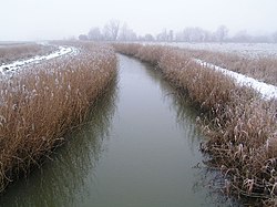
324:
550:
605:
585:
535:
560:
520:
580:
565:
525:
515:
277:
187:
178:
540:
505:
375:
350:
313:
293:
292:
The course of the river passes through agricultural land between
Laxfield and
216:
203:
147:
134:
590:
570:
305:
281:
273:
183:
43:
403:
265:
118:
494:
367:
269:
261:
257:
99:
89:
461:
320:
trunk road before entering the estuarine section of the river.
425:
349:
canal was opened in 1761 running 7 miles (11 km) from
378:. The river's name itself comes from an Old English word
242:
232:
193:
177:
163:
124:
114:
105:
95:
85:
80:
30:
366:The river gives its name to the settlements of
473:
8:
64:
480:
466:
458:
72:Location of the river mouth within Suffolk
19:For other rivers named River Blyth, see
391:
27:
7:
448:A Dictionary of British Place Names
370:, indicating a formerly important
14:
617:Suffolk East Management Catchment
488:
296:, flowing through the estate of
63:
56:
36:
382:meaning "gentle or pleasant".
195: • coordinates
126: • coordinates
16:River in east Suffolk, England
1:
335:Walberswick rowing boat ferry
106:Physical characteristics
304:before being crossed by the
234: • elevation
165: • elevation
21:River Blyth (disambiguation)
493:Rivers and watercourses of
246:30.5 km (19.0 mi)
633:
450:. Oxford University Press.
18:
501:
400:"blythweb.co.uk - Source"
173:
110:
51:
35:
426:"blythburgh.net - Tidal"
268:and it reaches a tidal
169:58 m (190 ft)
316:it is crossed by the
264:. Its source is near
42:The River Blyth near
374:over the river, and
238:0 m (0 ft)
330:Drowning by Numbers
300:and the village of
256:is a river in east
213: /
144: /
148:52.2995°N 1.3398°E
612:Rivers of Suffolk
599:
598:
546:River Little Ouse
356:Southwold Railway
310:East Suffolk Line
250:
249:
217:52.3133°N 1.675°E
624:
492:
482:
475:
468:
459:
452:
451:
443:
437:
436:
434:
432:
422:
416:
415:
413:
411:
406:on 16 April 2012
402:. Archived from
396:
347:Blyth Navigation
298:Heveningham Hall
228:
227:
225:
224:
223:
218:
214:
211:
210:
209:
206:
166:
159:
158:
156:
155:
154:
149:
145:
142:
141:
140:
137:
127:
67:
66:
60:
40:
28:
632:
631:
627:
626:
625:
623:
622:
621:
602:
601:
600:
595:
497:
486:
456:
455:
445:
444:
440:
430:
428:
424:
423:
419:
409:
407:
398:
397:
393:
388:
364:
343:
325:Peter Greenaway
290:
235:
221:
219:
215:
212:
207:
204:
202:
200:
199:
196:
164:
153:52.2995; 1.3398
152:
150:
146:
143:
138:
135:
133:
131:
130:
125:
76:
75:
74:
73:
70:
69:
68:
47:
24:
17:
12:
11:
5:
630:
628:
620:
619:
614:
604:
603:
597:
596:
594:
593:
588:
583:
578:
573:
568:
563:
558:
553:
551:Minsmere River
548:
543:
538:
533:
528:
523:
518:
513:
508:
502:
499:
498:
487:
485:
484:
477:
470:
462:
454:
453:
438:
417:
390:
389:
387:
384:
363:
360:
342:
339:
289:
286:
248:
247:
244:
240:
239:
236:
233:
230:
229:
222:52.3133; 1.675
197:
194:
191:
190:
181:
175:
174:
171:
170:
167:
161:
160:
128:
122:
121:
116:
112:
111:
108:
107:
103:
102:
97:
93:
92:
87:
83:
82:
78:
77:
71:
62:
61:
55:
54:
53:
52:
49:
48:
41:
33:
32:
15:
13:
10:
9:
6:
4:
3:
2:
629:
618:
615:
613:
610:
609:
607:
592:
589:
587:
586:River Waveney
584:
582:
579:
577:
574:
572:
569:
567:
564:
562:
559:
557:
554:
552:
549:
547:
544:
542:
539:
537:
536:River Gipping
534:
532:
529:
527:
524:
522:
519:
517:
514:
512:
509:
507:
504:
503:
500:
496:
491:
483:
478:
476:
471:
469:
464:
463:
460:
449:
446:A. D. Mills.
442:
439:
427:
421:
418:
405:
401:
395:
392:
385:
383:
381:
377:
373:
369:
361:
359:
357:
352:
348:
340:
338:
336:
332:
331:
326:
321:
319:
315:
311:
307:
303:
299:
295:
287:
285:
283:
279:
275:
271:
267:
263:
259:
255:
245:
241:
237:
231:
226:
198:
192:
189:
185:
182:
180:
176:
172:
168:
162:
157:
129:
123:
120:
117:
113:
109:
104:
101:
98:
94:
91:
88:
84:
79:
59:
50:
45:
39:
34:
29:
26:
22:
561:River Orwell
521:Butley River
510:
447:
441:
429:. Retrieved
420:
408:. Retrieved
404:the original
394:
379:
365:
344:
328:
322:
291:
253:
251:
25:
581:Stour Brook
576:River Stour
566:Oulton Dyke
526:River Deben
516:River Brett
511:River Blyth
431:6 September
410:6 September
278:Walberswick
254:River Blyth
220: /
188:Walberswick
151: /
606:Categories
541:River Lark
531:River Dove
506:River Alde
386:References
376:Blythburgh
351:Halesworth
341:Navigation
314:Blythburgh
294:Halesworth
205:52°18′48″N
136:52°17′58″N
591:River Yox
571:River Rat
556:River Ore
306:A144 road
282:North Sea
274:Southwold
208:1°40′30″E
184:North Sea
139:1°20′23″E
44:Wenhaston
327:'s film
308:and the
272:between
266:Laxfield
119:Laxfield
81:Location
495:Suffolk
368:Blyford
362:History
302:Walpole
284:coast.
280:on the
270:estuary
262:England
258:Suffolk
100:Suffolk
90:England
86:Country
380:blithe
288:Course
243:Length
115:Source
96:Region
186:near
179:Mouth
31:Blyth
433:2012
412:2012
372:ford
345:The
276:and
252:The
318:A12
608::
337:.
260:,
481:e
474:t
467:v
435:.
414:.
46:.
23:.
Text is available under the Creative Commons Attribution-ShareAlike License. Additional terms may apply.