38:
376:
There are numerous factories, warehouses and plants along the river providing goods, services and jobs, but a few of these cause pollution to the local environment and waterways. In order to help tackle pollution, the
600:
617:
303:. The Haigh Brook and Redbrook continue down the valley fed by more tributaries, until they converge at a scenic spot called Close Gate or Eastergate Bridge where the River Colne is formed.
384:
On 24 May 2010, part of a chemical factory was accidentally set ablaze and caused waste to be emptied into the river and the canal causing the deaths of many fish.
652:
42:
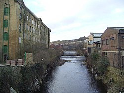
The River Colne at the bottom of Chapel Hill just outside
Huddersfield Town Centre. The mill on the left is Folly Hall Mill built in 1822 by Joseph Kaye.
176:
515:
349:
Due to the soft, acidic waters of the River Colne and its brooks flowing through the side valleys (cloughs) from the peat moors above, the
542:
473:
645:
584:
422:
97:
1262:
1201:
1004:
949:
788:
638:
327:
268:
158:
20:
1267:
944:
738:
693:
683:
748:
703:
362:
1065:
723:
489:
438:
1272:
311:
260:
162:
37:
296:
1257:
1221:
1105:
843:
808:
300:
1156:
1151:
838:
353:
was renowned for producing some of the highest quality woollen and cotton cloth produced anywhere.
758:
378:
576:
580:
469:
418:
366:
1171:
334:
231:
1136:
1120:
1100:
1141:
1075:
1070:
989:
903:
873:
813:
768:
569:
288:
252:
1251:
1196:
1186:
994:
939:
908:
833:
818:
1236:
1226:
1191:
1176:
1146:
1024:
1019:
1009:
974:
964:
913:
868:
828:
823:
778:
718:
393:
350:
323:
307:
264:
1216:
1211:
1206:
1181:
1110:
1085:
1080:
1029:
999:
979:
969:
918:
893:
878:
863:
858:
853:
793:
763:
713:
688:
338:
319:
315:
143:
373:. The river itself is too shallow and rocky to be navigable by any watercraft.
1231:
1166:
1090:
1060:
1055:
1014:
984:
934:
888:
883:
848:
798:
783:
773:
753:
743:
728:
708:
678:
673:
337:, Bradley Brook, Crimble Brook, Mag Brook, Fenay Brook, New Mill Dike and the
191:
178:
112:
99:
19:
This article is about the River Colne in West
Yorkshire. For other uses, see
1115:
1050:
1034:
954:
898:
733:
698:
567:
Palmer, Marilin; Neaverson, Peter (1998). "2: Landscapes and
Townscapes".
803:
370:
284:
256:
516:"How Greenstreams has improved Huddersfield's River Colne and many more"
1161:
56:
630:
1095:
291:, flow down the hillsides through the small valleys known locally as
263:. It flows in an easterly direction through the Colne Valley and
365:
follows the course of the river through the valley, as does the
280:
255:
is formed at the confluence of two brooks that originate in the
634:
468:(C2 ed.). 1:50,000. Landranger. Ordnance Survey. 2004.
279:
Brooks formed by rainwater high (between 300 and 480 metres
240:
381:
demand that certain standards be met by local companies.
326:
and then on to Cooper Bridge where it feeds the larger
243:
237:
1129:
1043:
927:
666:
234:
215:
207:
168:
152:
142:
128:
89:
79:
71:
62:
52:
47:
30:
568:
543:"Focus on Huddersfield's proud textile heritage"
571:Industrial Archaeology; principles and practice
306:The river flows from west to east through the
267:towards Cooper Bridge where it flows into the
85:Confluence of Redbrook Clough and Haigh Clough
646:
8:
653:
639:
631:
575:(1 ed.). London: Routledge. p.
490:"Colne from Eiver Holme to River Calder"
417:. Oxford: Clarendon Press. p. 90.
405:
439:"Colne from Source to Wessenden Brook"
27:
601:"Sub Micron Industries Ltd pollution"
7:
14:
230:
36:
16:River in West Yorkshire, England
622:The Huddersfield Daily Examiner
605:The Huddersfield Daily Examiner
541:Whitwam, Linda (12 July 2013).
170: • coordinates
91: • coordinates
1:
618:"Grosvenor Chemicals apology"
219:95 square miles (245 km)
63:Physical characteristics
466:Sheffield & Huddersfield
130: • elevation
547:Huddersfield Daily Examiner
520:Huddersfield Daily Examiner
154: • location
81: • location
1289:
18:
363:Huddersfield Narrow Canal
138:
67:
35:
1044:East Riding of Yorkshire
333:Its tributaries include
413:Ekwall, Eilert (1968).
1263:Rivers of Huddersfield
494:environmentdata.org.uk
443:environmentdata.org.uk
211:12 miles (19 km)
134:768 feet (234 m)
496:. Environment Agency
445:. Environment Agency
192:53.68028°N 1.73111°W
113:53.60528°N 1.95778°W
661:Rivers of Yorkshire
607:, 12 February 2010.
415:English River Names
301:Redbrook Reservoirs
188: /
109: /
1268:Rivers of Kirklees
379:Environment Agency
197:53.68028; -1.73111
118:53.60528; -1.95778
1245:
1244:
369:railway, and the
367:Huddersfield Line
223:
222:
1280:
655:
648:
641:
632:
625:
614:
608:
599:Lavigueur, Nick
597:
591:
590:
574:
564:
558:
557:
555:
553:
538:
532:
531:
529:
527:
512:
506:
505:
503:
501:
486:
480:
479:
461:
455:
454:
452:
450:
435:
429:
428:
410:
310:passing through
250:
249:
246:
245:
242:
239:
236:
203:
202:
200:
199:
198:
193:
189:
186:
185:
184:
181:
131:
124:
123:
121:
120:
119:
114:
110:
107:
106:
105:
102:
92:
82:
40:
28:
1288:
1287:
1283:
1282:
1281:
1279:
1278:
1277:
1248:
1247:
1246:
1241:
1137:Blackburn Brook
1130:South Yorkshire
1125:
1121:Winestead Drain
1101:Lambwath Stream
1039:
923:
667:North Yorkshire
662:
659:
629:
628:
615:
611:
598:
594:
587:
566:
565:
561:
551:
549:
540:
539:
535:
525:
523:
514:
513:
509:
499:
497:
488:
487:
483:
476:
463:
462:
458:
448:
446:
437:
436:
432:
425:
412:
411:
407:
402:
390:
359:
347:
335:Wessenden Brook
277:
233:
229:
196:
194:
190:
187:
182:
179:
177:
175:
174:
171:
155:
129:
117:
115:
111:
108:
103:
100:
98:
96:
95:
90:
80:
43:
24:
17:
12:
11:
5:
1286:
1284:
1276:
1275:
1273:Aire catchment
1270:
1265:
1260:
1250:
1249:
1243:
1242:
1240:
1239:
1234:
1229:
1224:
1219:
1214:
1209:
1204:
1199:
1194:
1189:
1184:
1179:
1174:
1169:
1164:
1159:
1154:
1149:
1144:
1139:
1133:
1131:
1127:
1126:
1124:
1123:
1118:
1113:
1108:
1103:
1098:
1093:
1088:
1083:
1078:
1073:
1071:Driffield Beck
1068:
1063:
1058:
1053:
1047:
1045:
1041:
1040:
1038:
1037:
1032:
1027:
1022:
1017:
1012:
1007:
1002:
997:
992:
987:
982:
977:
972:
967:
962:
957:
952:
947:
942:
937:
931:
929:
928:West Yorkshire
925:
924:
922:
921:
916:
911:
906:
901:
896:
891:
886:
881:
876:
871:
866:
861:
856:
851:
846:
841:
836:
831:
826:
821:
816:
814:Pickering Beck
811:
806:
801:
796:
791:
786:
781:
776:
771:
766:
761:
756:
751:
746:
741:
736:
731:
726:
721:
716:
711:
706:
701:
696:
691:
686:
681:
676:
670:
668:
664:
663:
660:
658:
657:
650:
643:
635:
627:
626:
624:, 24 May 2010.
609:
592:
585:
559:
533:
522:. 12 July 2013
507:
481:
475:0-319-228-40-1
474:
464:"110" (Map).
456:
430:
423:
404:
403:
401:
398:
397:
396:
389:
386:
358:
357:Infrastructure
355:
346:
343:
289:West Yorkshire
276:
273:
253:West Yorkshire
221:
220:
217:
213:
212:
209:
205:
204:
172:
169:
166:
165:
156:
153:
150:
149:
146:
140:
139:
136:
135:
132:
126:
125:
93:
87:
86:
83:
77:
76:
73:
69:
68:
65:
64:
60:
59:
54:
50:
49:
45:
44:
41:
33:
32:
15:
13:
10:
9:
6:
4:
3:
2:
1285:
1274:
1271:
1269:
1266:
1264:
1261:
1259:
1256:
1255:
1253:
1238:
1235:
1233:
1230:
1228:
1225:
1223:
1220:
1218:
1215:
1213:
1210:
1208:
1205:
1203:
1200:
1198:
1195:
1193:
1190:
1188:
1187:Old Hay Brook
1185:
1183:
1180:
1178:
1175:
1173:
1170:
1168:
1165:
1163:
1160:
1158:
1155:
1153:
1150:
1148:
1145:
1143:
1140:
1138:
1135:
1134:
1132:
1128:
1122:
1119:
1117:
1114:
1112:
1109:
1107:
1104:
1102:
1099:
1097:
1094:
1092:
1089:
1087:
1084:
1082:
1079:
1077:
1074:
1072:
1069:
1067:
1064:
1062:
1059:
1057:
1054:
1052:
1049:
1048:
1046:
1042:
1036:
1033:
1031:
1028:
1026:
1023:
1021:
1018:
1016:
1013:
1011:
1008:
1006:
1003:
1001:
998:
996:
995:Meanwood Beck
993:
991:
988:
986:
983:
981:
978:
976:
973:
971:
968:
966:
963:
961:
958:
956:
953:
951:
948:
946:
943:
941:
940:Bradford Beck
938:
936:
933:
932:
930:
926:
920:
917:
915:
912:
910:
907:
905:
902:
900:
897:
895:
892:
890:
887:
885:
882:
880:
877:
875:
872:
870:
867:
865:
862:
860:
857:
855:
852:
850:
847:
845:
842:
840:
837:
835:
834:Risedale Beck
832:
830:
827:
825:
822:
820:
819:Ramsdale Beck
817:
815:
812:
810:
807:
805:
802:
800:
797:
795:
792:
790:
787:
785:
782:
780:
777:
775:
772:
770:
767:
765:
762:
760:
757:
755:
752:
750:
747:
745:
742:
740:
737:
735:
732:
730:
727:
725:
722:
720:
717:
715:
712:
710:
707:
705:
702:
700:
697:
695:
692:
690:
687:
685:
682:
680:
677:
675:
672:
671:
669:
665:
656:
651:
649:
644:
642:
637:
636:
633:
623:
619:
613:
610:
606:
602:
596:
593:
588:
586:0-415-16626-8
582:
578:
573:
572:
563:
560:
548:
544:
537:
534:
521:
517:
511:
508:
495:
491:
485:
482:
477:
471:
467:
460:
457:
444:
440:
434:
431:
426:
424:9780198691198
420:
416:
409:
406:
399:
395:
392:
391:
387:
385:
382:
380:
374:
372:
368:
364:
356:
354:
352:
344:
342:
340:
336:
331:
329:
325:
321:
317:
313:
309:
304:
302:
298:
294:
290:
286:
282:
274:
272:
270:
266:
262:
258:
254:
248:
228:
218:
214:
210:
206:
201:
173:
167:
164:
160:
157:
151:
147:
145:
141:
137:
133:
127:
122:
94:
88:
84:
78:
74:
70:
66:
61:
58:
55:
51:
46:
39:
34:
29:
26:
22:
1258:Colne Valley
1237:Wyming Brook
1227:Totley Brook
1192:Porter Brook
1020:Tyersal Beck
975:Hebble Brook
959:
869:Skelton Beck
779:Holgate Beck
759:Greta (Lune)
719:Crimple Beck
621:
612:
604:
595:
570:
562:
550:. Retrieved
546:
536:
524:. Retrieved
519:
510:
498:. Retrieved
493:
484:
465:
459:
447:. Retrieved
442:
433:
414:
408:
394:Colne Valley
383:
375:
360:
351:Colne Valley
348:
332:
328:River Calder
324:Huddersfield
308:Colne Valley
305:
292:
278:
269:River Calder
265:Huddersfield
226:
224:
159:River Calder
25:
1217:Shire Brook
1182:Meers Brook
1111:Trent Falls
1086:Hedon Haven
1081:Gypsey Race
1000:Pudsey Beck
970:Harden Beck
945:Black Brook
859:Skeeby Beck
794:Malham Beck
764:Gypsey Race
689:Bedale Beck
616:Casey, Sam
552:21 November
526:21 November
500:21 November
449:21 November
339:River Holme
320:Milnsbridge
316:Slaithwaite
297:March Haigh
227:River Colne
195: /
116: /
31:River Colne
21:River Colne
1252:Categories
1172:Little Don
1167:Limb Brook
1061:Arram Beck
985:Holme Beck
774:Hodge Beck
744:Eller Beck
709:Costa Beck
679:Arkle Beck
400:References
259:close to
216:Basin size
180:53°40′49″N
101:53°36′19″N
1116:West Beck
1051:Aike Beck
1035:Wyke Beck
955:Cock Beck
699:Cock Beck
283:) in the
183:1°43′52″W
104:1°57′28″W
1142:Cheswold
1076:Foulness
990:Laneshaw
904:Washburn
874:Skirfare
804:Oak Beck
769:Hertford
704:Cod Beck
388:See also
371:A62 road
295:to fill
285:Pennines
257:Pennines
48:Location
1197:Rivelin
1162:Ea Beck
1066:Derwent
909:Wenning
844:Sea Cut
829:Riccall
724:Derwent
345:History
312:Marsden
293:cloughs
261:Marsden
163:Bradley
57:England
53:Country
1202:Rother
1177:Loxley
1147:Dearne
1096:Humber
1025:Wharfe
1010:Ryburn
1005:Ribble
965:Dearne
950:Calder
914:Wharfe
824:Ribble
583:
472:
421:
275:Course
208:Length
148:
75:
72:Source
1222:Torne
1212:Sheaf
1207:Ryton
1030:Worth
980:Holme
960:Colne
919:Wiske
894:Twiss
879:Swale
864:Skell
854:Seven
789:Leven
714:Cover
161:near
144:Mouth
1232:Went
1157:Dove
1106:Ouse
1091:Hull
1056:Aire
1015:Spen
935:Aire
889:Tutt
884:Tees
849:Seph
809:Ouse
799:Nidd
784:Kyle
754:Foss
739:Dove
729:Dibb
694:Burn
684:Bain
674:Aire
581:ISBN
554:2016
528:2016
502:2016
470:ISBN
451:2016
419:ISBN
361:The
318:and
299:and
281:AMSL
225:The
1152:Don
899:Ure
839:Rye
749:Esk
734:Doe
322:to
287:of
251:in
1254::
620:,
603:,
579:.
577:27
545:.
518:.
492:.
441:.
341:.
330:.
314:,
271:.
241:oʊ
654:e
647:t
640:v
589:.
556:.
530:.
504:.
478:.
453:.
427:.
247:/
244:n
238:k
235:ˈ
232:/
23:.
Text is available under the Creative Commons Attribution-ShareAlike License. Additional terms may apply.