29:
218:
28:
108:
257:
162:
196:
77:
81:
53:
262:
137:
42:
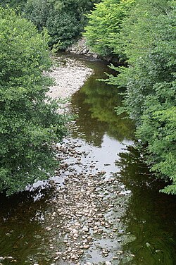
49:. It flows for around 22 km, in a generally northerly and then easterly direction.
251:
73:
57:
56:
at an elevation of about 490 metres, and falls rapidly until it reaches the floor of
65:
112:
233:
220:
85:
61:
166:
46:
207:
69:
109:"Loch Meiklie area – map of – Loch Meiklie, Highland – at"
60:at elevation about 120 metres. From that point the
21:
64:closely follows its course. It flows through
8:
163:"Photo of Scotland – Loch Meiklie, Balnain"
132:
130:
103:
101:
97:
198:Am Baile, Highland History and Culture
157:
155:
18:
80:about 100 metres before flowing into
7:
209:Ness District Salmon Fishery Board
14:
27:
111:. Pagemost.com. Archived from
1:
165:. Panoramio. Archived from
279:
26:
72:. It then flows through
234:57.33125°N 4.45219°W
187:Ordnance Survey maps
169:on 25 September 2011
76:and merges with the
230: /
258:Rivers of Scotland
239:57.33125; -4.45219
115:on 20 October 2011
41:is a river in the
35:
34:
270:
245:
244:
242:
241:
240:
235:
231:
228:
227:
226:
223:
210:
205:
199:
194:
188:
185:
179:
178:
176:
174:
159:
150:
149:
147:
145:
134:
125:
124:
122:
120:
105:
31:
19:
278:
277:
273:
272:
271:
269:
268:
267:
248:
247:
238:
236:
232:
229:
224:
221:
219:
217:
216:
214:
213:
206:
202:
195:
191:
186:
182:
172:
170:
161:
160:
153:
143:
141:
136:
135:
128:
118:
116:
107:
106:
99:
94:
43:Highland region
17:
12:
11:
5:
276:
274:
266:
265:
260:
250:
249:
212:
211:
200:
189:
180:
151:
138:"Loch Meiklie"
126:
96:
95:
93:
90:
52:It rises near
33:
32:
24:
23:
15:
13:
10:
9:
6:
4:
3:
2:
275:
264:
261:
259:
256:
255:
253:
246:
243:
208:
204:
201:
197:
193:
190:
184:
181:
168:
164:
158:
156:
152:
139:
133:
131:
127:
114:
110:
104:
102:
98:
91:
89:
87:
83:
79:
78:River Coiltie
75:
74:Drumnadrochit
71:
67:
63:
59:
58:Glen Urquhart
55:
50:
48:
44:
40:
30:
25:
20:
215:
203:
192:
183:
171:. Retrieved
167:the original
142:. Retrieved
117:. Retrieved
113:the original
82:Urquhart Bay
66:Loch Meiklie
54:Loch na Stac
51:
39:River Enrick
38:
36:
22:River Enrick
237: /
252:Categories
222:57°19′53″N
173:18 October
144:18 October
140:. Am Baile
119:18 October
92:References
84:, part of
263:Loch Ness
225:4°27′08″W
86:Loch Ness
62:A831 road
47:Scotland
70:Balnain
68:, near
16:River
175:2011
146:2011
121:2011
37:The
45:of
254::
154:^
129:^
100:^
88:.
177:.
148:.
123:.
Text is available under the Creative Commons Attribution-ShareAlike License. Additional terms may apply.